Enclosing resources on the islands of Kinmen and Xiamen: From war blockade to financializing natural heritage
Graduate Institute of Environmental Education, National Taiwan Normal University, Taipei, Taiwan hmtsai@ntnu.edu.tw
Graduate Institute of Culture and History of South Fujian, National Quemoy University, Kinmen, Taiwan
Depatment of East Asian Studies, National Taiwan Normal University, Taipei, Taiwan
Abstract
The cultures of the islands of Kinmen and Xiamen, also respectively Quemoy and Amoy, are tightly interwoven with the South China coastal region of Fujian. Both archipelagos played important historical roles in coastal defense and have been home to many Overseas Chinese since the 19th Century. A decisive battle in the Chinese Civil War was fought on Kinmen in 1949, cutting off Kinmen’s connection with Xiamen and Fujian. Positioned on a critical frontier between the ‘free world’ and the ‘communist world’, self-sufficiency became militarily important in the event of a blockade. After 1979, Xiamen was designated as a special economic zone attracting large flows of foreign investment and experiencing rapid urban development. Since 2002 the scheduled ferries between Kinmen and Xiamen reopened connections between Kinmen and its neighbor cities in the People’s Republic of China. Renewed exchange highlighted the remarkable differences between the two archipelagos’ developmental paths that had developed over the course of the 53-year suspension of contact. This paper analyzes these divergent developmental paths through comparative case studies involving forms of enclosure. The wetland conservation at Tzi Lake in Kinmen as well as gentrified residential developments around Yuan-dan Lake in Xiamen are compared; changing relationships, the impact of the sudden re-opening of borders, new forms of enclosure under globalization; and regional flows of capitals are discussed.
Keywords
Islands, Kinmen, Xiamen, Special economical zone, Taiwan strait
Introduction – the geographical and historical connections of Kinmen and Xiamen islands
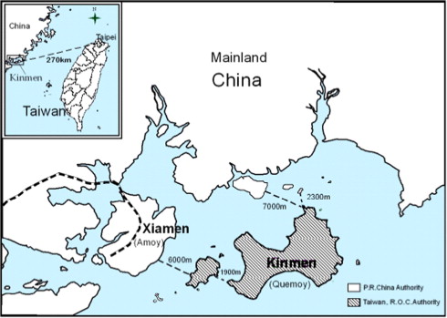
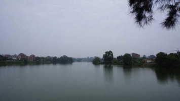
Kinmen (or Quemoy) is an archipelago composed of the main island Kinmen, Lieyu (also called ‘Little Kinmen’) and other surrounding small islands, with a total area of around 153 km2. The history of the island Kinmen is closely knit with that of the coastal region of Fujian (Ng, 1983). The island has a strategic location in the Xiamen Bay or the estuary of Julong River in Fujian Province, facing a number of Chinese cities, including Tong-An District to the north, Jinjiang District and Quanzhou City to the east, and Xiamen Island and Zhangzhou City to the west. On the other hand, it is nearly 200 km across ocean between Kinmen and Taiwan Island – the later central government location after 1949.
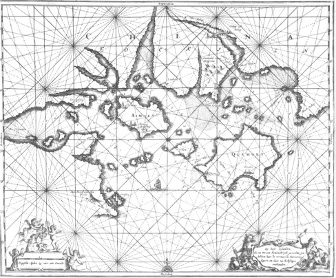
The island of Xiamen and its surrounding small islands have an area of 128 km2 and are located at the same bay area with Kinmen Islands (Fig. 1). Historically there was a close geographical relationship between Kinmen and Xiamen, with both serving as a gateway to the coastal areas and territorial seas of southern Fujian. In addition to their geographical relationship, Kinmen and Xiamen possess a shared political, social, and cultural history. Clans from the Central Plain of Mainland China began settling on these islands in the 4th Century. Both islands became important strategic costal defense sites since 1380s in the Ming Dynasty, and started marine trade from the early 17th Century to compete and cooperate with Western companies (such as The Dutch East India Company – Vereenigde Oost-Indische Compagnie, VOC). On a 17th Century European map, dated 1670, it’s shown two islands with the names spelled by local dialect as Amoy and Qumoy (Fig. 2).
During the second half of the 17th Century, Koxinga (General Cheng Cheng-Gong) and his followers confronted the Ch’ing Dynasty on behalf of the last emperor of the Ming Dynasty on these two island groups. At that time, Kinmen and Xiamen islands also served as military base for launching attacks on Dutch-occupied Taiwan in 1662. After 20 years confrontation, the Kinmen and Xiamen islands were forced to incorporated into the Ch’ing Dynasty in 1683. Since then the major trade routes from the islands were mainly along coastal areas of Mainland China (Ng, 1983). By the mid-19th Century, Xiamen was designated as one of the five ‘Treaty Ports’ to international trade under the Treaty of Nanjing1 (signed in 1842) due to the failure of Chinese army in a succession of battles against British forces at the first Chinese–British Opium War in 1839–1842. Since then, as one of the treaty ports, Xiamen began serving as a free port to the world and gradually became the economic center of southern Fujian. Many Kinmen people also moved overseas via Xiamen port, and that the Kinmen–Xiamen archipelago became the homeland of a large number of Overseas Chinese.
After World War II and Chinese–Japanese War ending in 1945, the Chinese Civil War between Russian supported Communists party and the Nationalists government of Republic of China fought throughout the country, and the nationalist were defeated and withdrawn from Mainland to islands of Taiwan in the end of 1949. In October 1949, the decisive battle was fought on Kinmen Island, ending with a wall through the archipelago and cutting off Kinmen’s connections with Xiamen. Positioned on a critical frontier not only between communist People’s Republic of China and nationalist Republic of China, but also between the ‘free world’ and the ‘communist world’ as one of the boarder during the world’s Cold War era, the islands development have been greatly restrained.
From 1949 to 1992, tens of thousands of soldiers were stationed in Kinmen, and military facilities of every kind were set up in the archipelago. Considerable state funds were injected for geostrategic purposes, including the ability to survive a long blockade. Thus, strictly regulated efforts got underway to promote reforestation, ensure an adequate water supply, boost agricultural and pastoral land to secure food self-sufficiency, and introduce drought-resistant sorghum for the mass production of liquor (kaoliang) for export as a source of income (Tsai, 2003). Cross-strait relations have however markedly improved in recent years; and Kinmen has transited “from battlefield to cross-strait bridge” (Taiwan Today, 2011; Baldacchino and Tsai, 2014).
‘Facing each other’: the development of Xiamen and Kinmen Islands in the Post-Cold War era
Xiamen: special economic zone after the 1980s
Under the tense atmosphere of the confrontation between both coasts, the development of Xiamen had also been hindered after 1949. In May of 1980, following the end of the Cultural Revolution, the Central Committee of the Communist Party of China and the State Council designated Xiamen City to run as a special economic zone (SEZ) together with three other coastal cities (Fujian Daily, 2011). In February 1984, the range of the SEZ was extended to all of the islands of Xiamen and adjacent countryside which had been linked with Xiamen Island with bridges, covering an additional 13.1 km2, allowing the gradually adopt a special economic zone policy.
In fact, by the 1980s, Xiamen was no longer a military base targeting Kinmen and Taiwan, nor an island, but was instead a city striving to implement the state’s experimental economic policy and to deploy external capital, making economic development its raison d’être. Long-term development planning meant that, by 1998, Xiamen was home to 3987 foreign-funded enterprises, had approved 4523 projects using investment by foreign commercial enterprises, possessed general foreign investment totaling US$ 9.128 billion. By the end of 2010, Xiamen had approved 9007 foreign investment projects in total (including many investment from Taiwan expended companies) and had actually utilized foreign capital worth as much as US$ 22.32 billion. It has also shifted its industrial structure from labor-intensive industries to advanced manufacturing industries (such as electronics and aerospace machinery), creation of industrial chains, and actively promoted service and logistics industries.2
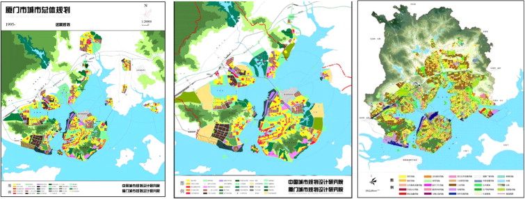
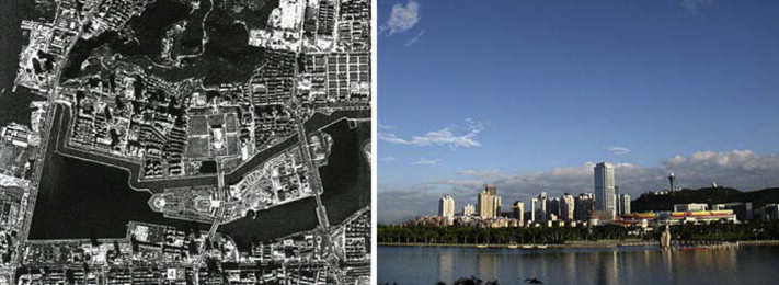
A great change has also taken place in its construction of urban infrastructure and townscape. The urban area of Xiamen has expanded from 13.8 to 65.6 km2 since 1995 (Fig. 3). In 2011, the registered population of the city amounted to 1,852,600 while the resident population rose to more than 3,611,000. The city has been developed from an ‘island city’ into a ‘bay city’.
Kinmen: Post-Cold War development after 1992
As tense frontier sites between the ‘free world’ and the communist regime during the Cold War (Myers, 1996), the Kinmen Islands (along with the Matsu islands, further up the Fujian coast) were significantly militarized since 1949 (Szonyi, 2008). Tensions between Mainland China and Taiwan gradually diminished in the early 1990s, and thus the military administration in Kinmen, named ‘War Zone Administration Committee’ (WZAC), ended on November 7, 1992. Although the long-term military administration depressed economic development, it left the traditional villages and ecology surprisingly untouched. After half a century of restricted development, political pressures built up to release all restrictions on development in a race to exploit the huge dammed up potential for development gains through land use change and investment in construction of housing, hotels and businesses. This aroused mobilization of conservation groups in a movement to sway public opinion for the protection of the island’s restored biodiversity, beautiful natural environment and unique historical and cultural heritage. After public debates and resource evaluation, in 1995, about one fourth of the land area of Kinmen Island and the coastline of Lieyu (Little Kinmen) Isle was designated as Kinmen National Park, and a new category in Taiwan’s national park system was established. In the context of a small island, it was not possible to set aside one continuous area, or to exclude populated areas. The park thus consists of five patches connected by green tree-lined roads. With an area of 37.2 km2, the patches include mountains, coastlines, lakes and bird habitats, and seven villages with unique historical built environments, war memorials and significant cultural relics (Clark and Tsai, 2002).
Furthermore, in order to devise a strategy for sustainable development, the local government of Kinmen County also issued the ‘Strategy and Plan for the Urban and Rural Development of Kinmen’ in 2006 and ‘Planning Guidelines for the Landscape of Kinmen’ in 2007, which contain four objectives for development: (1) the preservation of historical and classic settlements: Maintain the clan culture, consolidate the cohesion of community relations, save the folk culture and inherit the architectural art, and represent the island as heritages of the Southern Fujian culture; (2) the vitalization of the charming cities and towns: Harmonize the new and old landscapes, and improve the quality of life to allow characteristic local industries to be closed integrated with the urban space; (3) the reuse of the military landscapes: Aiming to become world heritage, turn the military landscapers into tourist attractions of historical Cold War sites; and (4) the sustainability of island development; Maintain the island’s bio-cultural diversity and the idyllic countryside scenery, as well as keeping societal equity and environmental sustainability while economic development.
In this comprehensive framework, the local government of Kinmen County has actively preserved the features of the historical settlement by restoring historical and cultural heritage such as the Overseas Chinese buildings and battle relics while maintaining the islands’ natural landscapes. Examples include the restoration of Jinlan Chen’s western-style building in Chengkung Village, the reuse of Fort Bravo and Fort Hero in Lieyu (or, Little Kinmen), the preservation of the original military barracks area on Jiangong Island, the landscape restoration of the Beshan settlement, the memorial park for the French Priest Bernard M. Druetto, the ecological remediation of Shanwai Stream, and so on (Chiang and Chen, 2009).
Financialization vs. conservation on island heritages: cases of Yuan-dan Lake in Xiamen and Tzi Lake in Kinmen
In the late 1980s and early 1990s, the tense atmosphere of military confrontation between PRC and ROC (Taiwan) gradually became less. Renewed exchange highlighted the remarkable differences between Kinmen and Xiamen – two border islands’ developmental paths that had developed over the course of the 53-year suspension of contact. Kinmen Island focused on environmental and cultural conservation while Xiamen emphasized the city’s modernization and economic development. Subject to this divergent development thinking, the two islands also took different approaches to manage their wetlands and nature heritages. Two development examples of Yan-dan Lake in Xiamen and Tzi Lake in Kinmen are illustrated as follows.
Urban wetland under economic development: the case of Yuan-dan Lake, Xiamen
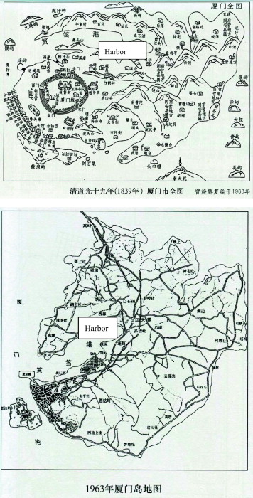
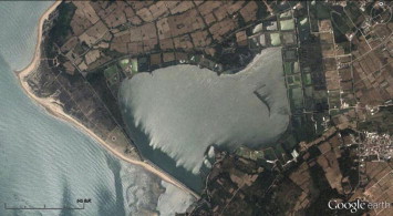
Yuan-dan Lake was formerly a harbor located in the western part of Xiamen Island, also called West Port, the water body in harbor was once around 10 km2 (Fig. 4). For centuries the landscape termed “Fishing Lights on Yuan-dan” was praised as one of the most popular scenery sites in Xiamen. However, in 1970, a seawall was built in the entrance of Yuan-dan harbor and that enclosed the water as a wetland. The wall was around 1700 m long, 5.3 m high, and 12 m wide at the top. In addition, an area of 7 km2 of water within the seawall was reclaimed into 5.4 km2 of Yuan-dan New District.3 From this point on, Yuan-dan Harbor became Yuan-dan Lake, with its surrounding areas becoming the city’s new residential and industrial districts. However, no coordinated projects were being carried out by the time of the development, and the domestic sewage produced by hundreds of thousands of the residents as well as industrial wastewater by more than 300 factories within the area of 37 km2 were all directly dumped into the lake without any treatment. By the 1980s, the lake was severely polluted, resulting in continual complaints by residents and finally attention from city authorities.
In November 1988, the Government of Xiamen City put forward the governance target to “renovate the Yuan-dan Lake and protect the west seashore area” by “intercepting water pollutants, dredging up and building up the shore, and improving the appearance of the environment.” In June 1992, the first stage of the renovation project for Yuan-dan Lake was completed, and the second stage was completed in September the same year.4 By 2011, after 40 years development since the sea wall was built in 1970, the lake’s water area has reduced from 10 km2 to current around 1.6 km2, and its green area is around 0.315 km2. After the renovation project and pollution controlled, its surrounding areas have transformed as the political, financial, and cultural centers of Xiamen City. For instance, Municipal Government and the People’s Hall of Xiamen City are located in the area while Bailuzhou Park, a mid-lake island, is a place for cultural activities (Fig. 5).5
Although the renovation of Yuan-dan Lake has become one of the prime modernization indices for the city’s development, the goal to renovate Yuan-dan Lake is less aimed at ecosystem conservation than at real estate development.
The business circle around the lake has become Xiamen’s ‘money magnet’ since there are many modern service businesses in commerce and trade, tourism, catering and recreation, and real estate. Some traditional shops, which mainly focused on local consumption, have been closed or relocated. This is a result of the gentrification brought about by the renovation of Yuan-dan Lake, which paved way for businesses that mainly focus on tourist consumption. In recent years, the rent has risen at least 300%.6 In the lakeside residential district, an area known as the ‘coffee street’ has emerged, bringing together more than 18 cafes. However, many negative externalities (such as roadside stall businesses, lack of parking space, lack of nighttime safety, and noise pollution) have been worsening.
Although the Yuan-dan Lake renovation was meant to be a demonstration of the changing of the landscape, the city authorities seem to be more interested in economic benefits than in upgrading the landscape. The 500 million dollars (yuans) of the renovation project investment were expected to bring 3 billion yuans of the benefits to the real estate industry (Xiamen Strait News, 2011). The former landscape – which integrated the ecology, production, and life – has been simplified into tourism activities, with sightseeing boats shuttling back and forth over the lake at night. Concern about the ecological environment in the renovation project has been woefully inadequate. For example, the mid-lake island, which ought to be the best place for ecological habitats, has become a crowded event square. The night view engineering has prevented birds from perching there. The enclosed body of water leads to high summer temperatures and massive algal blooms caused by eutrophication, which often cause small fish die of hypoxia (Xiamen Daily, 2013). The seawall, built in the 1970s should have been opened somewhere to let the tides pass in and out and to restore the function and ecological health of the wetland. However, more intensive human activities and more lighting projects have been introduced, leaving the renovated Yuan-dan Lake only as a popular big pool of water and an artificial scene for the commercial consumption of a city.
Community-based wetland conservation: the case of Tzi Lake
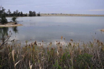
Tzi Lake is located in the north-western part of Kinmen Island, originally the fishing harbor for two villages (South Hill and North Hill) at Kuningtou where the decisive battle of the Civil War between communists PRC and nationalists ROC was fought here in October 1949. In 1969, the military War Zone Administration of Kinmen Defense started to build a 550 m causeway across the estuary or the entrance of harbor, and enclosed the area as a lake with a total area of 1.88 km2. The project primarily aimed at defending the enemy’s landing with the embankment and shortening the transporting supply distance between front lines; on the other hand, it also functioned as fishing pond or wetlands for aquaculture.
Biodiversity and cultural diversity are intrinsically related in the processes of coevolution that generate change in the patchwork quilt of cultural and natural landscapes (Clark and Tsai, 2002). Under more than 40 years of the cross-strait military confrontation tension, many landmines were buried on the sea shore outside of the embankment to prevent the enemy from landing, which made this area remote and abandoned, but leaving a friendly ecological habitat for birds. In 2007, Tzi Lake has been nominated as a nationally important wetland of Taiwan. Many migrant birds like cormorants often flock there in the winter, and nearly 200 kinds of other wild birds could be found there. The ecological source there is therefore very rich.7
In early 1995 when the Kinmen National Park was designated, a Special Landscape Area to maintain the bird habitats was planned in Tzi Lake, which occupies about 1.6 km2 including the lake surface and shore. The Special Landscape Area of Kinmen National Park means “the area where the special natural scenery there cannot be reproduced by human being and thus any development activities there are strictly prohibited; this project is to preserve the characteristic landscapes which have important commemorative value as the historical assets of the contemporaries and future generation….”8 With the National Park Project, the ecological environment of Tzi Lake has been taken into the legal protection, and the development activities have also been reviewed.
It is ironic to note that the opposite bank area which is 8 km away from the embankment has become the financial centers in the eastern part of Xiamen Island, where tall buildings lined up side by side and light up after nightfall; the scene has shaped a sharp contrast with the quite side of Tzi Lake in dark, and become one of the scenery that tourists in Kinmen could see when watching stars at night. This phenomenon also reflects the different developing paths that Kinmen and Xiamen chose in the initial Post-Cold War stage (Figs. 6–8).

Have islanders had the right to choose their own development paths? Part of ownership of Tzi Lake are privately-owned, especially the wetlands nearby the villages (named, Shuangli Wetlands). There are joint efforts with private and public sectors for a community-based conservation on wetlands.
Shuangli Wetlands is part of Tzi Lake with the area about 0.281 km2, historically owned by the Lee’s Clan that has lived beside the fishing harbors, now the wetlands, for centuries. Lee’s Clan have extended into three settlements named South Hill, North Hill, and Lincuo. After the human-induced boundary from 1949 to 1992, the slow process of natural succession with less disturbances have enriched the biodiversity of the area. More than forty years of port closures increased coastal sedimentation, which made possible the formation of various types of wetlands (for instance, mud-flats and mangrove swamps) and life forms (Tsai, 2003). The man-made causeway or embankment across the estuary that enclosed a 1.88 km2 water body and wetlands have also provided an excellent bird sanctuaries for the area. Some military bases on the hilltops or isolated coastal areas surrounding this Kuningtou historical battlefield have also become homes to diverse plant species.
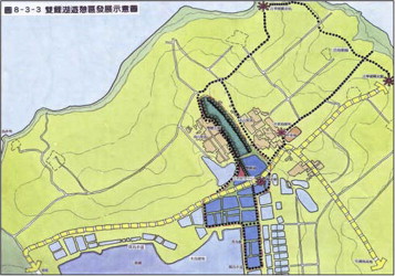
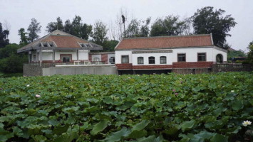
Due to this reason, its water body and the surrounding settlements are delimited into the range of the National Park as a Special Scenic Zone and recreation area which provided tourist visiting sites and education facilities.9 Thus, a Shuangli Wetland Center was set up as a place for environmental education and interpretation service (Fig. 9).
However, most land ownership of Shuangli Wetland are privately-owned. How to balance the public and private interests is important issue to be solved. Kinmen National Park Service proposed a system of heritages stewardship co-management system. It is fortunate that the traditional settlements on Kinmen are still kept as the Clan kinship commons system. Besides the private-owned houses and farmlands, the Clan common properties include ancestors clan temples, water resources, wetlands, fishponds, and part of farmlands. Therefore after the public participation meetings and consensus, the leaders of Clan (or community leaders) agree to set up co-management pledge, entitled “the pledge of superficies use” between governmental Park Service and the Clan Common Properties Stewardship Committee. According to the deal, on those public accessible wetlands and tourists service facilities the government signs up a contract to gain the rights to use the land for public services and pays the landlords 3% of the officially published land price as the rent every year. The rent for the pledge of superficies will be adjusted according to the raise of the published land price.
In the case of Shuangli Wetland (Fig. 10), due to the entire wetland and ‘abandoned’ farmlands are all the communal properties of the clans, the wetland has been rented to the Park Service by the commonalty “Lee’s Clansmen Association” at Kuningtou since 2001. The residents of villages are also involved with and benefited from the facilities on their common properties and the tourist business, such as the Nature Center’s educational services (Fig. 11), bird watching interpreters, cultural and historical heritage tour guides, or running craft shops. This cooperative local governance on national heritages with the stewardship efforts of both public and private sectors has brought the win–win situation for both local economic interests and the conservation of historical heritages and biocultural diversity.
Development dilemma: vanishing borders, being merged into economic zone?
In 2004, the PRC Fujian provincial government proposed a strategy to establish an economic zone on the western shore of the Taiwan Strait (i.e. Western Shore Economic Zone). In March 2011, The PRC State Council official approved the “Western Shore Economic Zone Development Plan.” Based on the plan, the Western Shore Economic Zone includes five major cities: Fuzhou, Xiamen, Quanzhou, Wenzhou, and Shantou. Among which, the development of Xiamen Bay aims to integrate Xiamen and Zhangzhou, and to construct as a center for commercial, financial, and high-tech industry.10 Western Shore Economic Zone and the development of Xiamen have great impact on Kinmen. Firstly, the special permissions between cross-Taiwan Strait passengers route via so called “Little Three Links” between Kinmen and Xiamen has significant increased, by which the number of entry and exit via the route has reached 9 million people between 2001 and 2012.11 Secondly, Kinmen County is financially in a good situation, and it has established a sound living environment and social welfare system for residents on islands. Therefore, household population has been growing in recent years. In 2000, the resident population in Kinmen was around 60,000; while in 2010, the resident population has reached 97,387.12 Also, it exceeded 110,000 in September 2012, being the highest population number among all the outlying islands of Taiwan (Lee, 2012).
Therefore, the previous strategy of historic preservation and ecological conservation faces a new challenge. In 2009, a pro-economic development Wo-shi Lee was elected as the county magistrate. Mr. Lee proposed economic development as a key policy of his term in office, and therefore commissioned a foreign consultant team to conduct the “Proposal of conceptual master plan for Kinmen County” in 2011 and officially released the proposal in 2013. The proposed project designed a series of constructions on targets toward so-called ‘2030 visions’ and to be completed then. The final goals for these construction projects are to develop Kinmen as a tax-free economic zone and an international city, and construct Kinmen to be the first Taiwan’s ‘intelligent island’, cross-strait commerce portal, new life style platform as well as an international tourism destination.13 And, aimed to be merged with the “Western Shore Economic Zone” of the PRC Fujian province and Xiamen special economic zone. Under the ideas of the plan, it will use high-intensity approach to utilize the land including a number of major public construction projects, such as a new airport, interisland bridges, and huge shopping malls.
These development pressures challenge the idea of nature conservation, historical sites, and culture heritages protection for the future generations. The continuous conservation efforts by national park has become the susceptible issue for public who aimed to pursue mass development. On the other hand, however, some non-governmental environmental organizations have different opinions on several current development plans approved by Kinmen County Government. For instance, in March 2013, a group of teachers who concerned about the island’s ecological environment for a long time, noticed that an under-construction access road abound extended Commercial Port has destroyed the protect habitat for mangroves and horseshoe crabs along Wushui River. Therefore, they protested and organized the Kinmen River Protection League that initiated ‘rights to island’ social movements and raised the awareness of general public. The strong voices from protests has eventually successfully forced the local government to suspend the construction. In addition, the League also questioned more than ten build-operate-transfer (BOT) projects approved by Kinmen County Government around the islands, and argued that these BOT projects mainly benefit the big corporations but not for the general public as the projects sacrifice the quality of public living environment.14
In other words, the current environmental conservation issues of Kinmen have become a public concerns. This demonstrates that there is dilemma between the choices of development paths in the post-Cold War Kinmen, and also indicates that there is a sprout of the civil society in Kinmen. Surprisingly the pro-development and ruling party supported County Magistrate Mr. Lee lost his champion for the second-term in the most recent nationwide local election held in November 29, 2014, while another candidate without any party supported Mr. Chen Fu-hai won. It is said that it was a victory of environmental groups and civil society of Kinmen Island on the choices of their home island’s development path.
Conclusion
Isolation is one of the key factors influencing evolutionary change for it creates conditions whereby the gene pool of a population becomes distinct from that of other populations. The human-induced political boundary from 1949 to 1992, even later, increased insularity of Kinmen Island and did provided an opportunity for natural succession and restoration, and a change for co-evolution between natural and cultural elements interacting and changing together to accumulate a unique and rich biocultural diversity on the island also benefit to the residents, island communities and local economy (Tsai, 2003). On the other hand, the penetration of financialization into the biocultural geographies of islands might bring in the fast development in the short term but would cause the disadvantages for local residents because the advance of “processes of commodification and privatization of environment, entailing enclosures of resource commons and displacement of people, livelihoods, knowledge and practices” (Clark, 2013, p. 129). The case of Yaan-dan Lake in Xiamen Island might be a case.
In addition, regarding to island identity, a rapid development path for a city or island which often sacrifice ecological environment and historical landscape and results in an “identity crisis.” According to the Istanbul Declaration on Human Settlements15 by the United Nations Conference on the Environment and Development, it proposed a concept of sustainable habitat addressed that an ideal city is a livable city established based on harmony with nature, social equity and eco-efficiency. It highlights the potential role of networking, citizens’ participation, and local government; and it also advocates that growth and development should be redefined from the perspective of quality of life, and should protect traditional culture and built environment with diversity. Therefore, with the increase of globalization, local nature-culture diversity and historic preservation have become crucial for global sustainability, and are particularly important factors for local communities and livelihood.
The accumulated pressure caused by the development of the new economic zone along the fast growth Chinese Fujian coastal region have impacted on both historical and geographical closely, but politically different islands: Kinmen and Xiamen. The choices of development paths in the post –Cold War era in the past 25 years might be a mirror for each other. In term of gross domestic product (GDP) data, the value of Kinmen is indeed less than that of Xiamen in general. However, based on the quality of nature environment, accumulated biocultural diversity, social equality and historical heritage, the development path and accumulated achievement of Kinmen during post-war period can be a model for other Chinese cities to learn. “Urban integration”16 has now become a trend and has expanded among the cities in the western coast economic zone of China, which might lead to be gradually demolishing different characteristics of many cities, and loosing identity.
Sustainability depends on robust and resilient social/cultural/ecological systems, for which biocultural diversity is crucial. In the slow processes that create global biological and cultural diversity, islands have played a significant role. Kinmen and Xiamen have very similar process in their historical changes; however, both islands also quite different development in recent paths. Like a pair of mirror images, through learning from each other and prioritize the local citizens rights to the island would be essential to the sustainable island development.
Acknowledgments
Work on this paper was made possible thanks to research grant from National Science Council of Taiwan (NSC 101-2621-M-003-002 and NSC 102-2621-M-003-004). The early draft of this paper was presented at the International Geographical Union Commission on Islands Conference, Island Development: Local Economy, Culture, Innovation and Sustainability, in Penghu Archipelago, Taiwan, 1–5 October 2013. Special thanks to Eric Clark, Adam Grydehøj and Sun-Kee Hong for helpful comments.
Endnotes
References
- Baldacchino and Tsai, 2014 G. Baldacchino, H.-M. Tsai Contested enclave meta-geographies: the Offshore Islands of Taiwan. Polit. Geogr., 40 (2014) (2014), pp. 13-24
- Chen, 1995 J. Chen The Topography of Xiamen [Xiamen di zhi]. Lujiang Publishing House, Xiamen (1995)
- Chiang and Chen, 2009 B.-W. Chiang, S.-Y. Chen Documentary of the Development of Urban and Rural Landscape of Kinmen. Kinmen County Government, Kinmen (2009)
- Clark, 2013 E. Clark Financialization, sustainability and the right to the island: a critique of acronym models of island development. J. Mar. Isl. Cult., 2 (2013), pp. 128-136
- Clark and Tsai, 2002 Clark, E., Tsai, H.-M., 2002. Co-evolution under globalization – boundaries lessons from Kinmen Island. In: Proceedings of the Fourth Conference on the Protected Areas of East Asia: Benefits Beyond Boundaries in East Asia, 18–23 March 2002 in Taipei, pp. 423–434.
- Fujian Daily, 2011 Fujian Daily, 2011. Development plan for economic zone of the western shore. Fujian Daily, April 9.
- Kinmen County Government, 2007 Kinmen County Government, 2007. Kinmen County Landscape Master Plan II. Unpublished.
- Kinmen County Government, 2013 Kinmen County Government, 2013. Proposal of conceptual master plan for Kinmen County. Unpublished.
- Kinmen River Protection League, 2013 Kinmen River Protection League, 2013. <http://kinmenriver.blogspot.tw/2013/04/blog-post_14.html> (14.04.13).
- Lee, 2012 Lee, C.-S., 2012. Population growth over 110,000 – Kinmen County mixed feelings, social welfare worries. China Times, October 13
- Liu, 2003 C. Liu (Ed.), From Yuandang Port to Lake Yuandang, Xiamen University Press, Xiamen (2003)
- Mainland Affairs Council, Executive Yuan. Little three links: number of ships traveling between Kinmen/Matsu and Mainland China, 2013 Mainland Affairs Council, Executive Yuan. Little three links: number of ships traveling between Kinmen/Matsu and Mainland China. <http://www.mac.gov.tw/public/Data/32114342771.pdf> (accessed 08.08.13).
- Myers, 1996 R.H. Myers A new Chinese civilization: the evolution of the Republic of China on Taiwan. China Q., 148 (1996), pp. 1072-1090
- Ng, 1983 C.K. Ng Trade and Society – The Amoy Network on the China Coast 1683–1735. Singapore University Press, Singapore (1983)
- Szonyi, 2008 M. Szonyi Cold War Island: Quemoy on the Front Line. Cambridge University Press, Cambridge (2008)
- Taiwan Today, 2011 Taiwan Today, 2011. Kinmen: from battlefield to cross-strait bridge. May 6. Available at: <http://taiwantoday.tw/ct.asp?xItem=162974&CtNode=428> (accessed 24.12.13).
- CPAMI, 1995 The Construction and Planning Agency, Ministry of the Interior (CPAMI), 1995. The Kinmen National Park Project. Unpublished.
- The Urban Planning Bureau of Xiamen City, 2010 The Urban Planning Bureau of Xiamen City, 2010. Comprehensive Planning for Xiamen 1995–2010, Xiamen City (in Chinese)
- Tsai, 2003 H.-M. Tsai Island biocultural assemblages: the case of Kinmen Island. Geografiska Annaler B, 85 (2003), pp. 209-218
- UN Conference on the Environment and Development, 2013 UN Conference on the Environment and Development, 2013. The Habitat Agenda, <http://www.unhabitat.org/downloads/docs/2072_61331_ist-dec.pdf> (accessed 18.08.13).
- Xiamen Daily, 2013 Xiamen Daily, 2013. Small fish cannot stand high temperature “baking”. Large quantity of dead fish on Yuan-dan Lake. Xiamen Daily, July 11.
- Xiamen Strait News, 2011 Xiamen Strait News, 2011. Environment of Xiamen is one of the national top four – renovation of Yuandang Lake increases a total property value of 3 billions. Xiamen Strait News, September 7