Human influence, regeneration, and conservation of the Gotjawal forests in Jeju Island, Korea
Department of Forest Resources, Graduate School, Kookmin University, Seoul 136-702, Republic of Korea birchkang@gmail.com
Warm-Temperate and Subtropical Forest Research Center, Korea Forest Research Institute, Jeju 697-050, Republic of Korea
Department of Forestry, Environment, and Systems, Kookmin University, Seoul 136-702, Republic of Korea kimeuns@kookmin.ac.kr
Abstract
Gotjawal, a uniquely formed forest vegetation on the lava terrain located at eastern and western parts of Jeju Island, covers 6% of the island’s land surface. The Gotjawal forests play important roles in establishing the biological and cultural diversity while maintaining ecosystem services. Recently, with the recognition of the diverse ecological and cultural values of the Gotjawal forests, efforts to conserve the forests were conducted by adopting the resolutions of the Jeju World Conservation Congress of the IUCN held in 2012. Despite its precious values, the Gotjawal forest is being threatened by the developmental activities of large scale constructions projects. To understand the recent regeneration of the Gotjawal forests, ecological studies have been conducted at the Hankyeong-Andeok Gotjawal Terrain, which is located in the western part and occupies the largest area of the Gotjawal Terrain of Jeju Island. Major vegetation in the area includes the deciduous broad-leaved forests (Acer palmatum–Styrax japonicus community), mixed deciduous and evergreen broad-leaved forests (Neolitsea aciculata–Styrax japonicus community), and evergreen broad-leaved forests (Quercus glauca community). In addition, the Gotjawal forests are evaluated as secondary forests mainly developed from sprouts. Tree-ring studies have revealed that the Gotjawal forests were regenerated from mid- to late-1960s after the cessation of human activities for using woods for various resources.
Keywords
Conservation, Ecosystem services, Gotjawal forests, Human influence, Jeju Island, Regeneration
Introduction
Jeju Island, located in the southernmost area of Korea, was formed by four volcanic activities that have occurred over the past 1.2 million years. During the process, in the hilly and mountainous area of Jeju Island (200–500 m above sea level), small parasitic volcanic craters called “Oreum” were formed (Jeju Special Self-Governing Province and National Folk Museum of Korea, 2007; National Geographic Information Institute, 2011). Highly viscose Aa lava flowed down from the Oreum, forming block type of rocky terrains (Song, 2000). People in Jeju Island gave various names to the forests formed in those areas, such as Goji, Golbat, Got, Gotsan, Jawal, Jawil, and Gotjawal (Jeju Development Center of History and Culture, 2010).
The Gotjawal areas were regarded as worthless lands, not suitable for farmlands because soils were poorly developed on predominantly rocky blocks. Recently, attempts have been made to systematically reassess the values and redefine the concept of the area, however. To explain the concept of the word “Gotjawal,” “Got” means the place where thorny bushes and trees coexist and “Jawal” means the wasteland where soils are shallow in development (Bukjeju County, 2000). A social corporate in Jeju Island, (Gotjawal peoples’ Association, 2005) could rediscover the uniqueness of the forests of the areas where highly viscose lava emerged from volcanic eruptions was later broken into large and small rocky blocks resulting in convexo-concave-shaped terrains. Here, the recharging of groundwater and the occurrence of warming and moistening allowed plant species of subtropical group and boreal group to coexist.
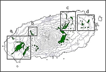
In Jeju, there are four Gotjawal terrains: the Hankyeong-Andeok Gotjawal terrain and Aewol Gotjawal terrain in west and the Jocheon-Hamdeok Gotjawal terrain and Gujwa-Seongsan Gotjawal terrain in east (Fig. 1). The area occupied by the terrains is about 110 km2, accounting for 6% of the land area of Jeju Island (Jeju Special Self-Governing Province, 2007).
Gotjawal forests have played important roles in the maintenance of ecosystem services among the natural ecosystems of Jeju Island. With increasing awareness of this value, conservation efforts have been expanded as well. The Jeju Special Self-Governing Province designated Gotjawal Terrains as a conservation area and the Daejung-Eup area in Seogwipo City of including Boseong, Gueok, and Sinpyeong-Ri areas encompassing about 155 ha has been identified as a Provincial Park (Jeju Daily News, 2011b). In addition, since 2009, the Jeju Special Self-Governing Province and the Korea Forest Service purchased private forests adjacent to national forests and conducted research after the designation of experimental forests (Jeju Daily News, 2011a). At the World Conservation Congress held in Jeju Island in September 2012, the motion entitled “Support for Conservation and Sustainable Use of Gotjawal Forests in Jeju” was adopted as a resolution (Jeju Daily News, 2012).
Despite these efforts in conservation, approximately 14% of entire Gotjawal area has already been destroyed by the development of golf courses, quarries, and amusement parks (SBS, 2012). Further, the Regulations for the Preservation and Administration of Gotjawal proposed by the Jeju Special Self-Governing Province in 2011 could not pass the deliberations of the Provincial Assembly because of objections raised from environmental NGOs and public opinions due to confusions in the definitions and concepts of Gotjawal, the absence of limits in the acts and regulations of penalties, insufficient discussion on designating Gotjawal as conservation areas, and the limitations in the provision of related preservation plans (Newsis, 2011). Although a variety of discussions have been conducted and consensus has been reached on the values and the needs for the conservation of the Gotjawal areas, the general consensus and effective institutional management measures have not been made based on the systematic and academic research.
This study was carried out to understand the ecology of the Gotjawal forests in vegetation, developmental processes of the forests, and the current status of the structure of the forests, which will be related to the discussion on potential conservation schemes of the Gotjawal terrains. Due to the lack of previous studies, the results of this study is expected to provide the baseline information for further studies on the Gotjawal terrains in Jeju Island, Korea.
Materials and methods
Ecological study: research area overview
To understand the formation of the Gotjawal forests and to describe its structure of them, research on the Hankyeong-Andeok Gotjawal terrain (33°15′23″–33°22′51″N, 126°15′28″–126°22′29″E) located in west area encompassing the four Gotjawal terrains of Jeju Island was carried out (Fig. 2).
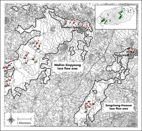
The Han Kyung-Andeok Gotjawal terrain is located within the range of 50–492 m above sea level in elevation, and its area is about 50.5 km2, occupying almost a half of the land area of Gotjawal terrains (total area: 110 km2) (Jeju Special Self-Governing Province, 2007). The topography of the Gotjawal terrain is rather flat on gentle slopes and, but due to its rocky block structure, the unevenness and the dentation of the surface are distinctive and small tumuli of dome-type are observed. The Han Kyung-Andeok Gotjawal terrain is distributed across the Daejung-Eup and Andeok-Myun in Seogwipo City; it is divided into two areas: the Wollim-Sinpyung lava flow area erupted from Doneori Oreum (329.6 m above sea level), whereas the Sangchang-Hwasoon lava flow area erupted from Daebyungak (492 m above sea level). The rock of the Wollim-Sinpyung lava is gray to dark gray augite-olivine basalt, whereas that of Sangchang-Hwasoon lava is grey porous feldspar–augite–olivine basalt (Song, 2000). Because of the geological characteristics of the land consisting of rocky blocks, soil development is very poor where organic layer and A layer are mixed. Generally, the depth of soil is very shallow with the depth of 10–15 cm. Soil is developed in the space among the rocky blocks where unevenness is observed.
Vegetation study
From April to June 2012, forty survey plots in 15 m × 15 m (26 plots at the Wollim-Sinpyung lava flow area and 14 plots at the Sangchang-Hwasoon lava flow area) were installed to elucidate the current conditions of the vegetation of the forests. Measurements of every tree in the plots were carried out for overstory, midstory, and shrub layer. For the overstory and midstory, each tree species was identified and the diameter of breast height (DBH), height of the tree, width of the crown were measured. The number of sprouts extending from one root or stem growing above the breast height was recorded.
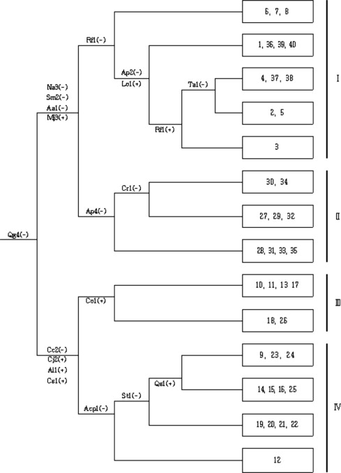
On the basis of the vegetation survey data, the importance value (IV) of the tree species for each layer was calculated using the method of Curtis and McIntosh (1951), and the species composition was identified as well (Yim, 1980). Community classification of vegetation was done by using TWINSPAN (Hill and Šmilauer, 2005).
Tree-ring study
To determine the ages and the growth histories of the overstory trees of the plots, the samples of growth rings from 2 to 3 individual trees showing good growth in each plot were collected with increment borer at the height of about 1 m. For each individual, two samples of growth rings were collected to reduce the errors caused by uneven growth, but in case when this was not possible, only one sample was collected. The collected samples of tree growth rings were mounted on wooden blocks to prevent damage after sampling. A total of 174 tree growth ring samples were collected from 106 individuals.
The tree rings mounted on wooden blocks were dried and polished, and then measured to the closest 0.01 mm unit by using LINTAB 5 Tree Ring Measuring System equipped with TSAP-Win Tree Ring Measuring Program. To improve the accuracy of measurement, the records of tree ring readings were cross-dated for the specific years when tree growth rapidly dropped and/or increased compared with the previous year (Kim, 1983). Comparisons were made for the graphs of growth of the individual trees, individual species, and individual plots. On the basis of the measured tree ring data, the years for regeneration of the trees were identified, and through this, the age of the stand was also estimated. As the tree ring samples were collected at 1 m in height, 3–5 years were added in estimating the actual age of the stand.
Biocultural diversity and ecosystem services study
To identify the biocultural diversity and ecosystem service value of the Gotjawal forests, previous studies on the history, geography, culture, and ecology were reviewed and interviews were conducted with residents of the study areas.
Results and discussion
Vegetation structure
To classify the vegetation in the study sites, TWINSPAN was conducted on 60 species, except for one species that occurred in less than 5% of the survey plots, among the 84 species that occurred in 40 survey plots. The results of vegetation analysis are presented in Fig. 3. The vegetation of survey area was classified into 4 groups. In vegetation group I, 58 species were identified and classified as deciduous broad-leaved forest vegetation of high importance value (IV) of trees: Acer palmatum Thunb. (15.08%), Styrax japonicus Siebold & Zuccarini (12.60%), Mallotus japonicus (Thunb.) Muell.-Arg. (8.10%), and Celtis sinensis Pers. (6.88%). In vegetation group II, 51 species were identified and classified as mixed forest vegetation with evergreen broad-leaved trees and deciduous broad-leaved trees, with high importance value of trees: Neolitsea aciculata (Blume) Koidz. (13.18%), A. palmatum (10.30%), and S. japonicus (8.32%). In vegetation group III, 34 species were identified and classified as evergreen broad-leaved forest vegetation with an average importance values of 47.52%. The occurrence of Quercus glauca Thunb. was much higher than that of the other species. In vegetation group IV, 47 species were identified and the vegetation was similar to that in group III, and was classified as evergreen broad-leaved forest vegetation with high average importance value of trees. The occurrence of Q. glauca was 38.84%.
Density of sprouts
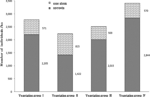
The study sites showed very high sprouts percentage in the overstory and midstory (Fig. 4). In vegetation group I, 2205 out of 2776 individual stems (79.4%) emerged from sprouts per ha. In vegetation group II, 1422 out of 2237 individual stems (63.6%) emerged from sprouts. In vegetation group III, 2015 out of 2518 individual stems (80.0%) emerged from sprouts. In vegetation group IV, 2844 out of 3414 individual stems (83.3%) emerged from sprouts, which was the highest among all vegetation groups. In each of the vegetation groups, the average number of stems or sprouts from one individual tree of a same root system was 3.7, 3.9, 4.0, and 4.9, respectively. The sprouts were mainly observed in S. japonicus, A. palmatum, and Q. glauca. The high sprouts density indicated that the forests of study sites were originated from the secondary forests influenced by heavy human interferences.
Forest age estimation
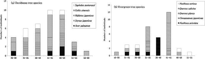
The ages of the trees were estimated by counting the tree rings of the tree species that showed high importance values in the study sites (Fig. 5). The ages of S. japonicus, A. palmatum, M. japonicas, and C. sinensis were mainly within the range of 41–50 years; the age of Q. glauca and Q. salicina was 41–45 years, and the age of N. aciculata was 36–40 years. The estimated ages of major tree species in each vegetation group are shown in Fig. 6. While the range of ages of the trees is between 18 and 58 years, mainly being distributed between 31 and 50.
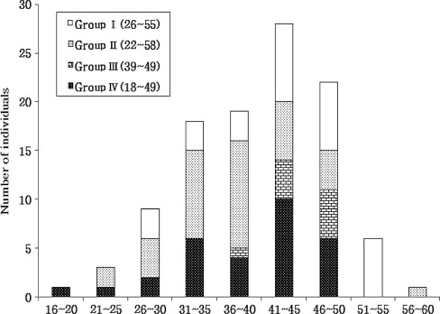
To confirm the years when the vegetation of the study sites had been formed, interviews with local residents were conducted. According to the interviews, the residents in the study sites continued to collect the woods from the Gotjawal area to use for woods for fuel, farm instruments, and furniture until mid-1960s to early 1970s. In areas of vegetation groups III and IV, even the people living at distant villages such as Mosulpo as well as nearby local residents came to cut the trees. Going further in time from then, the logging operation for the First Army Training Camp located in Mosulpo was conducted mainly in 1950s. In addition, the existence of kilns for the manufacturing pottery and charcoal located near the survey area indicates that a large amount of woods for fuel might have been collected from the area. Even after the initiation of the nationwide policy for the prohibition of logging, illegal logging was partly conducted to save money of fuel cost for briquettes. In 1980s, when city gas was provided to the local residents, logging in the Gotjawal area ceased. During the time when logging was conducted in the study sites, the tallest trees were said to be less than 1 m in height. Regardless of the distance from villages, all surveyed areas were said to be in the same situation. Based upon the results of this study on tree ages at 1 m in height through tree ring measurement and interviews with local residents conducted in this study, the study sites can be concluded to have been regenerated as the secondary forests since around the late 1960s, when human interference was significantly reduced. The ages of the forests in the areas with vegetation types I, III, and IV are estimated to be around 40–50 years old. In contrast, the years for maximum regeneration for the vegetation group II are observed in the mid-1970s, thus the ages of the forests have been estimated to be within the range of 30–40 years.
Biocultural diversity and ecosystem services
Biodiversity represents the structural aspect of ecosystems, where ecosystems give people and society such various benefits as provisioning services, cultural services, regulating services, and supporting services (Daily, 2000; Millennium Ecosystem Assessment, 2005). The value of Gotjawal is currently being reevaluated in terms of these ecosystem services (Fig. 7). In the flora of Gotjawal forests, 638 taxa (559 species, 5 subspecies, 57 varieties, and 17 forms) of tracheophytes have been identified, including 49 rare plant species that have been enlisted in the IUCN Red List of Threatened Species. The occurrence of many rare plant species may be attributed to wide array of environmental of the Gotjawal forests with the range of elevation from 50 m to 800 m above sea level as well as various types of growth environments located on the volcanic terrain (Ministry of Environment, 2012).
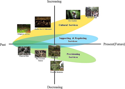
The various plants growing at the Gotjawal forests continued to play important roles in the daily life of the people living in Jeju Island. From the Gotjawal forests, they obtained firewood, timber, resources for medicine and food, as well as materials and resources for charcoal and pottery. The village community ranch that was formed since the Japanese colonial era used the Gotjawal for raising horses and cows (Kang, 2004; Yoon, 2006; Jeong, 2004, 2012). In addition, these places carry a painful history of Jeju Island: when the April 3rd Massacre occurred in 1948, the people of Jeju Island stayed in Gwe (small caves) or lava caves in Gotjawal to avoid the chasers (Jeong, 2004).
Recently, as the needs for resources from the Gotjawal forests decreased, the area was used as a research area for investigation on valuable plant species such as Illicium anisatum L., Cinnamomum camphora (L.) J. Presl, and Sapindus mukorossi Gaertner. The residents of Sanyang-Ri and Cheongsu-Ri of Hankyung-Myun of Jeju city and those of Hwasoon-Ri, Andeok-Myun of Seogwipo city voluntarily repaired the roads to the Gotjawal forests and provided various programs for eco-tourism, forest experience, and forest healing. These efforts contributed to the promotion and the reevaluation of the values of the Gotjawal areas.
Jeju Island has more average annual rainfall that that of the peninsula, but the rain runs off rapidly to the sea because of its high permeability due to volcanic rocks, short lengths of streams, and the steep slopes. For these reasons, people in Jeju Island mainly depend on groundwater for water supply (Gotjawal Trust Fund, 2012). In the mountainous and hilly areas of Jeju Island, Gotjawal, with the lava cave, dent area, and joint system-developed area, depends on the permeable geological structure for the supply of groundwater. Gotjawal has the broadest area (58%) among these, thus, playing a major role in the supply of groundwater (Jeju Island, 1997; Ministry of Environment, 2012).
Conclusions
Jeju Island is a unique place that has been designated as Biosphere Reserve, World Heritage Site, and World Geopark by UNESCO with the status and values of superior natural environment. In addition, the World Conservation Congress of the IUCN held in Jeju Island in September 2012 has announced its vision that Jeju Island be recognized as the World Environmental Capital. Comprehensive management plans and implementation schemes are needed to be established for the conservation of Gotjawal forests as their ecological and cultural values have been recently recognized.
Throughout this study, the ecology of the Gotjawal forests was studied indicating that they are rather young and secondary forests regenerated from heavy influence of human usages. After decrease of human interference of the 1960s–1970s, the Gotjawal forests are remaining ecological spaces because of rocky block terrain that is not suitable for farming. Gotjawal forests are the space with high biodiversity and are outstanding ecosystems with vast geological features and sceneries. Further, it is a historical place showing a cultural aspect of the forests in Jeju Island. Regardless of such values, Gotjawal areas are under the threats of large-scale developments for golf courses and amusement parks. These human activities thus prompt concerned groups to conserve the Gotjawal using an active and practical plan that is sustainable and relevant to the livelihoods of its residents. The following suggestions are thus proposed:
- (1)
- The Gotjawal Preservation and Administrative Regulations should be enacted reasonable consensus of the opinions of its inhabitants. In addition, long-term plans for the conservation of Gotjawal areas should be established not only by local scale in Jeju Island but also by national scale in Korea.
- (2)
- With respect to the campaign for communizing Gotjawal, which is currently being conducted through various channels, the conservation activity by the involvement of its citizens should be centralized and systemized to promote the participation of the people from the wider scales.
- (3)
- The academic research should be promoted and expanded to national and international scales to generate an effective and systematic management plan of the Gotjawal forests. The activities focusing on the conservation of ecosystems under heavy pressures of developments should be expanded beyond the spaces from the forests in Jeju Island, to model forests in Korea as well as the world to showcase the conservation activities of the people of Jeju Island and Korea to the world.
Acknowledgments
This research was sponsored by the research grant from the Warm-Temperate and Subtropical Forest Research Center of Korea Forest Research Institute and supported by research program of Kookmin University in Korea.
References
- Bukjeju County, 2000 Bukjeju County, 2000. Bukjeju County Records. pp. 93–101.
- Curtis and McIntosh, 1951 J.T. Curtis, R.P. McIntosh An upland forest continuum in the prairie-forest border region of Wisconsin. Ecology, 32 (1951), pp. 476-496
- Daily, 2000 G.C. Daily Management objectives for the protection of ecosystem services. Environ. Sci. Policy, 3 (2000), pp. 333-339
- Gotjawal People Association, 2005 Gotjawal peoples’ Association, 2005. What is Gotjawal? http://www.gotjawal.com/local/local_1.asp. (20/10/2012).
- Gotjawal Trust of Jeju, 2012 Gotjawal Trust of Jeju, 2012. The role and conservation plan of Gotjawal on Jeju. p. 237.
- Hill and Šmilauer, 2005 Hill, M.O., Šmilauer P. 2005. TWINSPAN for windows version 2.3. Center for Ecology and Hydrology & University of South bohemia, Huntingdona & Ceske Budejovice.
- Jeju Daily News, 2011a Jeju Daily News, 2011a. Government eager to conserve Gotjawal. (22/11/2011).
- Jeju Daily News, 2011b Jeju Daily News, 2011b. Gotjawal in Daejeong-Eup area will be designated as a regional park this year. (27/12/2011).
- Jeju Daily News, 2012 Jeju Daily News, 2012. Closing ceremony of Jeju WCC. Finale of the 10 days’ grand journey. (15/9/ 2012).
- Jeju Development Center of History and Culture, 2010 Jeju Development Center of History and Culture, 2010. UNESCO World Heritage Town of Jeju Seonheul 1 Ri. p. 146.
- Jeju Island, 1997 Jeju Island, 1997. Census of hilly and mountainous areas. p. 344.
- Jeju Special Self-Governing Province and National Folk Museum of Korea, 2007 Jeju Special Self-Governing Province and National Folk Museum of Korea, 2007. Jeju folk culture 4, Jeju Gotjawal. p. 180.
- Jeju Special Self-Governing Province, 2007 Jeju Special Self-Governing Province, 2007. Main report on the Jeju Island-managed conservation area overhaul services. p. 164.
- Jeong, 2004 K.J. Jeong Gotjawal and Jeju residents’ lives. Jeju University of Education, Thesis Collection., 33 (2004), pp. 41-65
- Jeong, 2012 K.J. Jeong A study on perception and use of Gotjawal in Jeju Island. J. Assoc. Korean Photogeogr., 22 (2012), pp. 11-28
- Kang, 2004 Kang, M.I., 2004. Jeju Island joint ranch management during the Japanese occupation. In: 19th Provincial Culture Contest Prize-Winning Paper, p. 17–74.
- Kim, 1983 Kim, E.S., 1983. Radial growth patterns of tree species in relation to environmental factors. (Ph.D. Dissertation). Graduate School, Yale University. p. 293.
- Millennium Ecosystem Assessment, 2005 Millennium Ecosystem Assessment (MEA)Ecosystems and Human Well-Being: Synthesis. Island Press, Washington, DC (2005). p. 155
- Ministry of Environment, 2012 Ministry of Environment, 2012. Study on the measures to take for the conservation and wise use of Gotjawal. p. 254.
- National Geographic Information Institute, 2011 National Geographic Information Institute, 2011. Korean Geography, Jeolla-Jeju section. p. 717.
- Newsis, 2011 Newsis, 2011. Jeju Environment Action Association “We Refuse the Empty-shell Conservation Act for Gotjawal”. (6/7/2011).
- SBS, 2012 SBS (Seoul Broadcasting System), 2012. Serious damages to privately owned Gotjawal lands. Deprivatization underway. (13/1/2012).
- Song, 2000 Song, S.T., 2000. Distribution and lithology of the Aa rubble flows in Cheju Island, Korea. (Doctoral thesis). Pusan National University. pp. 118.
- Warm-Temperate and Subtropical Forest Research Center, 2012 Warm-Temperate and Subtropical Forest Research Center, 2012. Measures for the conservation and use of Gotjawal. In: Material Collected from the Eco Forum for Building a World’s Environmental Capital.
- Yim, 1980 K.B. Yim Phytosociological change of Pinus densiflora forests induced by insect damage in Kyonggi-do area. J. Korean For. Soc., 50 (1980), pp. 56-71
- Yoon, 2006 S.J. Yoon The dissolving process of village pasture commons in Jeju Island and its social and ecological implication. J. Rur. Soc., 16 (2006), pp. 44-88