
Visual Politics of the Japanese Empire and the Dehistoricization of the South Seas Mandate: Representing Tropical Space in Postcard Images
 10.21463/jmic.2026.15.2.04
Abstract
This study examines how the South Seas Mandate (Nan’yō) was visually constructed through postcards produced under the Japanese Empire. While the South Seas Mandate functioned as a key site of Japan’s southward expansion, it was not simply incorporated into the imperial domain as a pre-given space; rather, it required cultural and visual mediation in order to be recognized within Japanese society as a “new southern region.” In this process, postcards played a central role in shaping how the region was perceived and imagined.
Focusing on approximately twelve postcard images, this study argues that the South Seas Mandate was represented as a dehistoricized tropical space through a systematic visual regime. These postcards repeatedly depict tropical landscapes and indigenous life while largely excluding historical traces and social conditions. Through this selective visual composition, the region is presented not as a historically layered place but as a stable and timeless environment. At the same time, images of modern infrastructure and administrative space depict the South Seas Mandate as an ordered and governed environment, while omitting the violence and labor underlying colonial development.
Building on Edward W. Said’s insight into the ahistorical logic of imperial representation, and extending the critique articulated by Naoto Horikiri regarding the surface-oriented and depoliticized nature of Japan’s southern imagination, this study demonstrates that visual images did not merely reflect colonial space but actively produced it. In particular, it shows how these representations contributed to the production of topophilia, understood as an affective attachment to place mediated through visual images.
By analyzing these visual strategies, this study argues that the South Seas Mandate was not simply represented but actively constructed as a “tropical paradise” through imperial visual politics. In doing so, it highlights how colonial space was produced not only through physical control, but also through the organization of perception and affect.
Keywords
South Seas Mandate, Nan’yō, visual politics, dehistoricization, topophilia, colonial visual culture, postcards
1. Introduction
After World War I, Japan occupied Micronesia, which had previously been under German control, and governed it as a League of Nations mandate known as the South Seas Mandate (Nan’yō). This region, which included Saipan, Palau, the Marshall Islands, and Truk, functioned as a key strategic base in Japan’s southward expansion. The Japanese government established the Nan’yō Government (Nan’yōchō) and actively promoted administrative control and economic development.
Beyond its political and economic significance, however, the South Seas Mandate also occupied an important place within the cultural imagination of the Japanese Empire. Because the islands were geographically distant from the Japanese mainland, their incorporation into imperial space required not only administrative governance but also cultural and visual mediation. The region had to be made visible, intelligible, and desirable to audiences in metropolitan Japan.
This study is situated at the intersection of colonial visual culture studies, postcard studies, and island studies. While previous scholarship on the South Seas Mandate has primarily focused on colonial administration, migration, economic development, and geopolitical expansion, relatively little attention has been paid to the visual mechanisms through which the region was represented and imagined within Japanese society. By examining postcards as visual media, this article contributes to broader discussions concerning the production of colonial space, imperial visuality, and the cultural construction of island territories.
Research on colonial visual culture and postcard representation has increasingly emphasized the role of visual media in shaping imperial perceptions of colonized regions. Rather than functioning as neutral records, visual images actively participated in the production of colonial knowledge, spatial imaginaries, and cultural hierarchies. Previous studies have examined colonial postcard cultures in Taiwan (Barclay, 2010) and Korea (Hyung Il Pa,i 2013), demonstrating how postcards contributed to the visual construction of colonial space and imperial identities. Particularly relevant to this study is Urakawa’s (2008) analysis of Japanese postcards depicting East Asia and Micronesia, which demonstrates how postcard images classified and objectified colonial subjects through visual representation. Beyond studies focusing on colonial subjects, research on Japanese representations of the South Seas has also highlighted the ideological construction of the region as an exotic and tropical space. Sudo (2010), for example, examines how the South Seas were imagined within Japanese cultural discourse through orientalist and romanticized representations. However, comparatively less attention has been paid to the visual mechanisms through which postcard imagery transformed colonial space itself into an ahistorical and timeless environment. While existing studies have illuminated colonial imagery and the representation of indigenous peoples, the visual reorganization of colonial landscapes as depoliticized and dehistoricized spaces remains underexplored.
However, this colonial regime cannot be understood solely in terms of military and economic domination. Although formally framed within the institutional structure of the League of Nations mandate system, the actual governance of the South Seas Mandate operated through the integration of administrative control, economic development, and population movement, effectively constituting a colonial regime. In particular, the expansion of sugar production and the activities of state-affiliated enterprises, together with the migration of Japanese settlers and the construction of urban infrastructure, reorganized the region as both a site of imperial production and a space of governance. In this process, indigenous societies were incorporated into a hierarchical colonial order. The South Seas Mandate thus functioned not merely as a peripheral territory, but as a strategic space in which imperial power was materially and institutionally consolidated(Lee, 2018).
At the same time, however, the South Seas Mandate was not simply recognized within Japanese society as an extension of imperial territory. It had to be redefined and made intelligible as a “new southern space” through cultural and visual mediation. In this context, postcards functioned as a crucial visual medium that disseminated images of the region across Japanese society.
In the modern period, postcards were a representative medium for circulating images of specific places and cultures to a mass audience. They played a particularly important role in representing tourist sites and colonial spaces, transforming geographically distant regions into visually accessible and consumable images. In the South Seas Mandate, numerous postcards were produced and widely circulated, and these visual images significantly shaped how Japanese viewers perceived and imagined the region.
A close examination of these postcards reveals a consistent visual pattern. Tropical landscapes and scenes of indigenous life are repeatedly foregrounded, while images depicting historical architecture or traces of the past are notably absent. This visual composition encourages viewers to perceive the South Seas Mandate not as a space layered with historical contexts, but as a space defined by nature and custom. Importantly, this pattern should not be understood as a simple matter of thematic selection. Rather, it reflects a structured visual logic that determines how the space is made visible.
As Edward W. Said has shown, imperial representation tends to detach colonized regions from history, rendering them as static and timeless spaces available for observation and consumption(Said, 2003). In the context of modern Japan, Naoto Horikiri similarly criticizes southern representations for remaining at the level of surface imagery, failing to engage with the lived realities of local populations or the structural conditions of colonial rule(Naoto Horikiri, 1997). Such representations, he argues, obscure the power relations and forms of violence embedded within colonial expansion, reducing the South Seas to an object of sensory curiosity.
Taken together, these perspectives suggest that visual representations of the South Seas Mandate did not simply reflect an external reality, but actively participated in constructing a particular mode of perception. From this perspective, postcards can be understood as visual devices that organize colonial space by determining what is made visible and what is excluded.
This study analyzes approximately twelve postcards of the South Seas Mandate in order to examine how the region was represented as a dehistoricized tropical space. In particular, it focuses on the repetitive visual structure of natural landscapes and indigenous figures, and explores how this process of dehistoricization is related to the formation of imperial affect, specifically the production of topophilia. Topophilia, a concept introduced by Yi-Fu Tuan, refers to an affective attachment to place formed through experience, memory, and cultural mediation. In colonial contexts, such attachment is not merely experiential, but is structured through visual and cultural representations.
Furthermore, this study argues that the South Seas Mandate was not merely a represented object, but an imperial space actively constructed through visual media. To substantiate this argument, it draws on postcard collections from three archives: the Kyoto University Rare Materials Digital Archive, the Edo-Tokyo Museum Digital Archives, and the Taipei City Archives. By cross-examining materials from different institutional contexts, the study minimizes potential regional biases and identifies recurring visual patterns and compositional consistencies. Rather than focusing on the uniqueness of individual images, this approach highlights how the imperial visual system operated in a systematic and structured manner.
Because the three archives employ different cataloguing systems and provide varying levels of descriptive information, it is difficult to determine the overall number of South Seas-related postcards represented in the collections. Rather than aiming for exhaustive coverage, this study selected twelve postcards that most clearly exemplify recurring visual categories observed across the archival materials, including tropical landscapes, indigenous life, and colonial development. The purpose of this selection is not to construct a comprehensive catalogue of surviving postcards, but to identify dominant visual patterns through which the South Seas Mandate was represented.
Among the materials examined, the source from the Taipei City Archives can be precisely dated to 1921 based on its caption, “Commemorative Photograph of the Naval Cruise to the South Seas, Spring of Taishō 10.” In contrast, the remaining postcards lack explicit information regarding their production dates and issuing bodies. Nevertheless, based on the urban landscapes depicted, the level of colonial infrastructural development, and the use of the term “Nan’yō,” these materials can be reasonably situated within the 1920s.
2. Postcards and Imperial Visual Culture
In the modern period, postcards emerged as a representative visual medium through which images of specific places were widely disseminated. The development of photography and printing technologies enabled their extensive use in tourism and colonial promotion, allowing landscapes and cultures from various regions to be visually reproduced and circulated on a large scale. Within this context, postcards evolved beyond simple recording devices and became a key medium shaping how particular spaces were perceived and understood(Prochaska and Mendelson, 2010; Burns 2004; Alloula, 1986).
To examine how such visual representations operated in the South Seas Mandate, this study analyzes twelve postcards selected from the Kyoto University Rare Materials Digital Archive, the Edo-Tokyo Museum Digital Archives, and the Taipei City Archives. The selection emphasizes recurring visual categories—tropical landscapes, indigenous life, and colonial development—that repeatedly appear across the available collections. These categories provide a basis for identifying the dominant visual logic through which the South Seas Mandate was represented.
In colonial contexts, postcards functioned as a key medium through which the imperial gaze was organized. As John Berger argues, the act of seeing is never neutral but is structured by social relations and power(Berger, 1972). Images do not simply convey reality as it is; rather, they produce meaning through processes of selection, framing, and arrangement. From this perspective, postcards can be understood not merely as representations of landscape, but as visual devices that determine how colonial space is made visible.
Similarly, W. J. T. Mitchell emphasizes that images are not passive reflections of reality but sites of meaning production shaped by ideology and power. Postcards provide a particularly clear example of this process(Mitchell, 1986). Within a limited visual frame, selected subjects and compositions stabilize particular interpretations of a place, while their repeated circulation contributes to naturalizing these interpretations. The landscapes presented through postcards are therefore not direct copies of actual spaces, but reconstructions produced within a specific visual order.
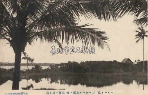
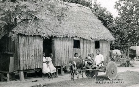
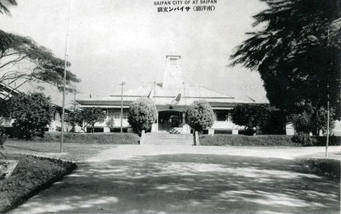
This process of visual reconstruction becomes especially pronounced in colonial contexts. As Edward W. Said demonstrates in Orientalism, imperial representations tend to emphasize exoticism, stasis, and ahistoricity. Such representational strategies detach colonized regions from their historical and political contexts and render them as spaces available for sensory consumption(Said, 2003). Postcards of the South Seas Mandate can be understood within this broader visual logic. Indeed, postcards produced in the region repeatedly organize their imagery around several key categories: natural landscapes, indigenous life, and Japanese administrative spaces. Figures 1, 2, and 3 illustrate how these categories are visually structured.
(Source: Taipei City Archives.)
(Source: Kyoto University Rare Materials Digital Archive.)
(Source: Kyoto University Rare Materials Digital Archive.)
Figure 1 is organized around palm trees, the sea, and a distant island, with no human presence visible within the frame. The gaze is directed from an external vantage point toward the island, positioning the space not as a site of habitation but as an object of observation. The composition is dominated by elements of nature—such as the silhouette of palm trees, reflections on the water, and the horizon—which detach the space from its social context. As a result, the South Seas Mandate is reduced to a static landscape. Nature does not function merely as a background for human activity; instead, it becomes the central subject of the image itself.
Figure 2 presents the living environment of Kanaka indigenous people. However, the actions of the figures are not situated within any identifiable context. There are no clear indications of social relations, such as whether the individuals form a family unit, nor are labor, social interaction, or historical conditions made visible. Rather than depicting a dynamic social environment, the scene is reduced to a fixed representation of “everyday custom.” The dwelling and the ox cart function as visual props, mobilized to signify “native life” rather than to convey lived experience. The figures themselves appear as arranged elements within the composition, resulting in a loss of vitality and the objectification of all elements in the image.
Figure 3 depicts the administrative building of the Nan’yō Government on Saipan. The structure is presented within a symmetrical composition and an orderly landscape, producing a strong impression of stability and authority. As the central administrative institution of Japanese rule under the League of Nations mandate, the Nan’yō Government oversaw governance, economic development, and population management. However, the actual operation of power remains invisible. Instead, the administrative space is presented as a completed and self-evident order, in which governance appears not as a process involving conflict or coercion, but as a natural and rational system.
Figures 2 and 3 belong to the same postcard set, titled Kanaka Dancing in the Ever-Summer Island: Customs and Landscapes of Saipan in the South Seas. These postcards present nature, indigenous life, and administrative space as distinct visual units. Although each image focuses on a different subject, they share a common visual structure: concrete human activity and social relations are consistently excluded, while the surface elements of landscape, custom, and governance are foregrounded.
In these images, palm-lined beaches foreground nature by eliminating traces of human labor, while indigenous life is reduced to a surface representation of custom, detached from historical context. At the same time, the administrative center of colonial rule is depicted as stable and orderly, while the material realities of power—such as labor control and coercion—are systematically omitted. Order and stability are thus presented not as processes, but as already accomplished conditions.
At first glance, these postcards appear to depict everyday life. In fact, they are carefully selected and constructed scenes shaped by a Japanese imperial gaze. They do not offer neutral representations, but rather present already interpreted and structured landscapes. Through this visual composition, the South Seas Mandate was positioned as a new southern space within the Japanese Empire.
Postcards did not merely show the region; they implicitly prescribed how it should be seen. Through this process, the South Seas Mandate came to be perceived as both exotic and familiar within Japanese society. The repeated circulation of such imagery played a crucial role in stabilizing this perception.
Ultimately, postcards cannot be understood as simple visual materials. They operated within an imperial visual system structured through selection, exclusion, repetition, and fixation. Although the images appear natural and self-evident, they are in fact constructed representations shaped by specific visual logics. In this sense, postcards of the South Seas Mandate functioned as visual devices that both represented and organized the meaning of colonial space.
This analysis provides a crucial foundation for understanding how postcards participated in the dehistoricization of colonial space. In this study, dehistoricization refers to a representational process through which colonial spaces are detached from their historical, political, and social contexts and reimagined as timeless environments. By removing traces of conflict, transformation, and power relations, such representations reorganize perception in ways that render colonial intervention less visible. As a result, colonial space appears natural, stable, and self-evident. This understanding draws upon Said’s discussion of ahistorical imperial representation while extending it to the visual organization of colonial landscapes and island spaces. From this perspective, the repeated visual patterns observed in postcards of the South Seas Mandate can be understood not merely as aesthetic choices, but as mechanisms through which colonial space was systematically dehistoricized.
3. The Representation of Tropical Nature
One of the most striking visual characteristics of postcards from the South Seas Mandate is the persistent emphasis on tropical landscapes. Islands encircled by coral reefs, expansive seascapes, and dense tropical vegetation—particularly palm trees—appear repeatedly as defining motifs of the region. Through this repetition, these elements do not merely depict specific locations; rather, they establish a visual framework that encourages viewers to perceive the South Seas Mandate as a typified space of “tropical nature.” To contextualize this visual vocabulary, this section also briefly considers several images from the broader sphere of Japanese southern representation beyond the South Seas Mandate itself.
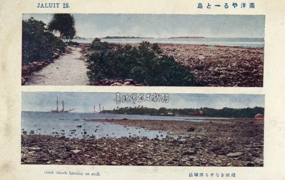
Images of coral islands and distant horizons evoke a sense of openness and spatial expansiveness, while scenes dominated by dense vegetation foreground an image of primitive abundance. Together, these representations produce a visual logic that dehistoricizes the region, framing it less as a historically situated place than as an abstract and generalized tropical environment. Figures 4, 5, and 6 demonstrate how this visual logic operates.
(Source: Taipei City Archives.)
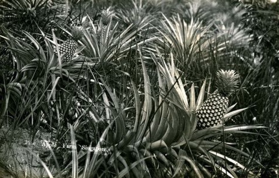
(Source: Kyoto University Rare Materials Digital Archive.)
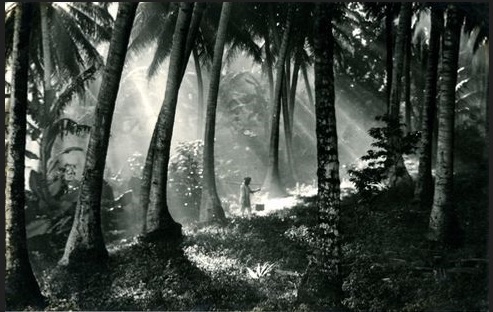
(Source: Kyoto University Rare Materials Digital Archive.)
Figure 4 presents a landscape of the Marshall Islands, emphasizing a coral-lined coast and an extended horizon. Human activity and traces of social life are almost entirely absent. The expansive sea, combined with a low vantage point, creates an open and continuous visual field. Rather than situating the viewer within a concrete location, this composition encourages a perception of the South Seas Mandate as a generalized tropical space. Nature is foregrounded as the dominant subject, while temporality and historical specificity are effectively suspended.
In Figure 5, a tropical fruit—pineapple—fills the frame, with particular emphasis placed on the density and form of the vegetation. Any indication of human presence or everyday life is excluded. The image reduces the region to a visual category of “tropical flora,” shifting attention away from geographical specificity toward a sensory impression of abundance. Here, vegetation itself becomes the primary visual agent, displacing social context and lived experience.
Figure 6 is structured around a palm forest, with light and shadow producing a layered visual depth. Although spatial depth is present, human activity remains indistinct or absent. The composition is dominated by the interplay of forest, light, and atmosphere, transforming the space into a sensory environment. At the same time, concrete social conditions are omitted, and the scene is presented as a natural setting detached from temporality and historical process.
Taken together, these images reveal a consistent pattern: human activity and social traces are systematically minimized, while nature is foregrounded as an autonomous visual field. As a result, the South Seas Mandate is not presented as a historically grounded space, but as an environment seemingly removed from the flow of time.
This mode of representation cannot be reduced to a simple act of recording landscape. Rather, it reflects a series of deliberate visual choices that structure perception itself. Such representations detach colonized regions from historical processes, rendering them as static and consumable spaces. Within this framework, southern imagery remains confined to surface appearances, thereby obscuring the structural realities of colonial rule. The repeated emphasis on tropical nature in these postcards can thus be understood as part of a broader visual strategy.
At this point, it becomes necessary to reconsider the concept of landscape itself. As Denis Cosgrove, a leading cultural geographer whose work has emphasized landscape as a cultural and symbolic form, has suggested, landscape is not identical with nature, but is instead a symbolic form produced within specific social relations and structures of power(Cosgrove, 1984). From this perspective, the tropical scenes depicted in postcards of the South Seas Mandate are not neutral representations of the environment. They are “seen landscapes,” selected, framed, and organized through an imperial gaze.
In this sense, natural imagery does not function merely as a background. Instead, it operates as a central mechanism for organizing sensory perception. The sea, palm trees, and tropical vegetation together produce a visual surface that frames the South Seas Mandate as a space of tranquility and aesthetic pleasure. These elements create an experiential field in which the region is encountered not as a site of conflict or transformation, but as a stable and harmonious environment.
Such representations play a decisive role in constructing the South Seas Mandate as an “exotic paradise.” As Said has demonstrated, imperial discourse frequently emphasizes exoticism and stasis, thereby removing colonized regions from historical time. The repeated depiction of unchanging natural landscapes in these postcards reinforces precisely this effect, presenting the region as a space immune to historical transformation.
Importantly, these visual constructions are closely tied to the production of affect. Expansive seascapes and tranquil environments evoke sensations of calm, stability, and leisure in the viewer. These sensory responses are not incidental; they are structured through the visual composition itself. As Nicholas Mirzoeff, a leading scholar of visual culture, has argued, visual culture operates not only by representing objects, but by organizing sensory experience (Mirzoeff, 1999). In this context, tropical nature functions as an affective environment that encourages viewers to perceive the South Seas Mandate as a space free from tension and conflict.
In conclusion, the representation of tropical nature in postcards of the South Seas Mandate extends far beyond the depiction of physical scenery. It functions as a visual apparatus that shapes how the region is experienced and understood. Through the consistent foregrounding of nature, historical context and social conditions are systematically excluded from view.
Within this framework, the representation of tropical nature can be understood as a key mechanism in the production of topophilia. Originally conceptualized by Yi-Fu Tuan, a humanistic geographer known for his studies of place and human experience, as an affective bond between people and place, topophilia is often understood as emerging from lived experience and sensory engagement with the environment. (Tuan, 1974). However, in the colonial context of the South Seas Mandate, such attachment did not arise from direct experience but was mediated through visual representation.
Repeated images of tranquil seas, palm-lined shores, and lush vegetation produced a sensory environment in which the region appeared stable, peaceful, and desirable. Topophilia, in this sense, was not a spontaneous emotional response, but an affect structured through visual culture. Postcards played a decisive role in this process by organizing not only what could be seen, but also how it was to be felt. Accordingly, tropical nature operates as a central mechanism in constructing the South Seas Mandate as a dehistoricized space.
This dynamic is directly connected to the broader problem of dehistoricization, which will be examined in the following chapter.
4. The South Seas Mandate as a Dehistoricized Space
A close examination of postcards from the South Seas Mandate reveals a consistent visual pattern: while natural landscapes and indigenous life are repeatedly foregrounded, images depicting historical architecture or traces of the past are strikingly absent. This absence should not be understood as a simple bias in subject matter. Rather, it reflects a structured visual logic through which the South Seas Mandate is actively constituted as a particular kind of space.
One of the most striking features of these images is that the depicted subjects appear fixed in a state of primitiveness. Indigenous dances, everyday scenes, and traditional attire are not presented as practices situated within historical change. Instead, they are rendered as if a single moment has been isolated and indefinitely preserved. Rather than revealing temporal layers—such as continuity, transformation, or accumulation—these images produce the impression of an unchanging present.
Figures 7, 8, and 9 demonstrate how this dehistoricizing logic operates at the level of visual composition.
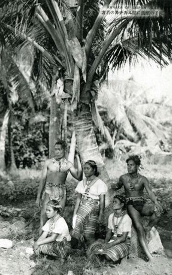
(Source: Kyoto University Rare Materials Digital Archive.)
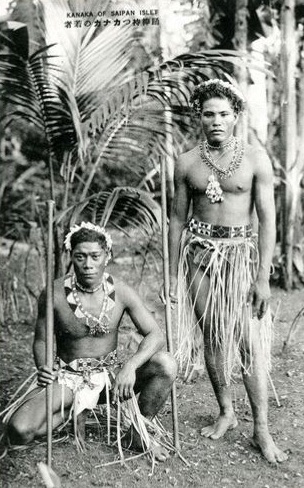
(Source: Kyoto University Rare Materials Digital Archive.)
(Source: Kyoto University Rare Materials Digital Archive.)
Figure 7 portrays a group of indigenous people resting beneath palm trees. The figures are minimally clothed, with only essential parts of the body covered, and are positioned as bodies embedded within nature. No indication of labor, social interaction, or historical context is provided. Through this arrangement, indigenous people are displaced from their status as historical and social subjects, and are instead incorporated into the natural landscape. Because no historical context, social relations, or evidence of change is presented, the figures appear detached from processes of conflict, transformation, and colonial intervention. As a result, they are represented not as historical actors but as timeless elements of the tropical environment. The collective stillness of the scene further reinforces this effect by eliminating any sense of temporal progression and inviting the viewer to imagine a repetitive and static mode of existence.
Figure 8 presents young men in Saipan holding sticks associated with dance. Their traditional ornaments and attire are emphasized, yet these elements are not situated within any identifiable cultural or historical framework. Rather than appearing as individuals engaged in a specific activity, the figures are rendered as generalized types. The upright posture and frontal orientation suppress any sense of movement, producing an image that resembles a staged or catalogued display. In this way, indigenous bodies are transformed into visual specimens, reinforcing a colonial logic that classifies and fixes them as representations of “custom.”
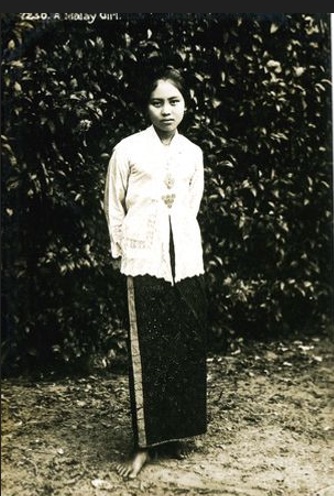
Figure 9, labeled as a “Malay woman,” presents a frontal portrait with minimal background and context. The figure is reduced to a visual object defined primarily through clothing and physical appearance. These elements function as markers of exoticism, while personal history and lived experience are systematically excluded. As a result, the individual is reconfigured as a typified and classifiable Other.
Taken together, these representational strategies detach the South Seas Mandate from historical time. Imperial representation operates by removing temporality and fixing the Other as a static image. Such ahistorical representation transforms colonized regions from sites of change and conflict into objects of observation and consumption. The repeated depiction of indigenous figures in these postcards can be understood within this framework.
In particular, indigenous bodies and ways of life are consistently categorized under the label of “custom”. Individual histories and social conditions are excluded, and figures engaged in dance or posed in specific gestures are not presented as actors within a concrete context. Instead, they appear as visual types. This mode of representation reduces indigenous people to elements of the natural landscape rather than historical subjects.
Equally important is what remains unseen. Traces of the past—such as historical architecture, pre-colonial heritage, or signs of conflict and transformation—are almost entirely absent. This absence should not be understood as a simple lack. Rather, it is the result of deliberate processes of selection and exclusion. What is not shown is as significant as what is shown.
Dehistoricization, therefore, is not merely the omission of the past. It is a visual strategy that structures how colonial space is perceived. Once historical context is removed, space is detached from conflict, violence and domination, and is reconfigured as an object of viewing and aesthetic appreciation. In this process, colonial intervention and governance are rendered invisible, while imperial rule appears natural and self-evident.
Images, in this sense, do not simply reflect reality but operate within systems that produce meaning. By excluding historical traces and foregrounding nature and “custom,” postcards of the South Seas Mandate reconstruct the region as a space stripped of temporal accumulation. The South Seas Mandate thus appears as a space that exists only in the present, with its past effectively erased.
Ultimately, the dehistoricization observed in these postcards is not incidental. It is a systematic effect produced within an imperial visual order. The repeated emphasis on nature and custom separates the South Seas Mandate from the flow of time, creating an ahistorical condition. This condition, in turn, enables its subsequent representation as a “tropical paradise.” In this sense, dehistoricization operates as a crucial condition for the production of imperial topophilia.
5. The Constructed Paradise of Development
Postcards of the South Seas Mandate depict not only tropical nature and indigenous life, but also images of Japanese administration and development. Urban streets, administrative buildings, and commercial facilities visually demonstrate how Japan reorganized the region into a modern space. These images, combined with the nature-centered postcards discussed earlier, encourage viewers to perceive the South Seas Mandate not as a purely natural environment, but as a “developed space.”
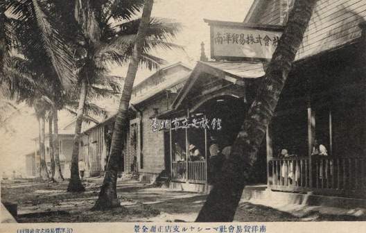
For example, postcards featuring branch offices of the Nan’yō Trading Company, government buildings of the Nan’yō Government, and well-ordered streets emphasize regularized architecture and spatial order. These visual elements suggest that Japanese administrative control and economic development brought stability and order to the region. In particular, straight roads and modern buildings stand in contrast to the natural environment, highlighting that the South Seas Mandate was a space reorganized under Japanese rule.
(Source: Taipei City Archives.)
(Source: Edo-Tokyo Museum Digital Archives.)
(Source: Edo-Tokyo Museum Digital Archives.)
Figure 10 presents the South Seas Mandate as an economic hub, while also incorporating rows of palm trees in the background. This composition combines nature and economic infrastructure within a single visual frame. The buildings and signage symbolize the imperial network of circulation and capital, while the palm-lined street visually reinforces the tropical character of the region.
However, nature is not presented as an autonomous environment. It appears as ordered and aligned with the linear arrangement of roads and buildings. Palm trees function not merely as elements of scenery, but as components that organize spatial order. This suggests that nature in the South Seas Mandate was not separate from economic development, but integrated into it. Thus, the image does not reduce the region to either tropical nature or economic infrastructure alone. Instead, it represents a space in which the sensory qualities of nature and the economic order of empire are combined.
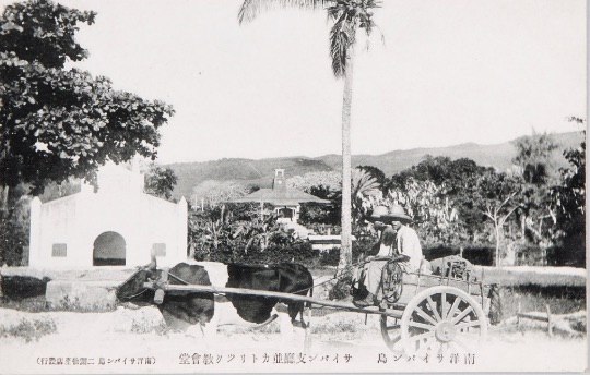
Figure 11 is structured around modern buildings, including a branch office of the Nan’yō Government and a Catholic church. In the foreground, a local resident and an ox cart are included. Palm trees and gently sloping terrain also appear within the frame.
As a result, the image presents a space where tropical nature, everyday life, and modern institutions coexist. This visual composition plays a key role in constructing the South Seas Mandate as a “paradise.” The natural setting and everyday scenes create a calm and stable atmosphere, presenting the region as a space free from threat or tension. However, this “paradise” is not depicted as untouched nature. The presence of administrative and religious buildings clearly indicates that the space is organized under imperial governance and institutional order.
The ox cart and the local resident are also significant. They represent traditional ways of life, yet are positioned within a modern spatial order. This suggests that the South Seas Mandate is not merely a natural environment, but a space stabilized through imperial intervention and control. In other words, the image constructs a “paradise” not by excluding human life, but by incorporating it into an administrative and institutional framework.
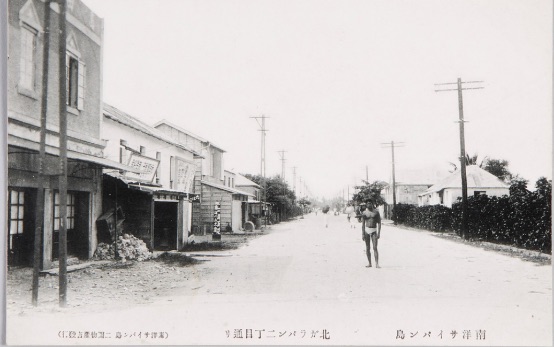
Figure 12 emphasizes a modern urban space through a straight road and regularly arranged buildings. The linearity of the road and the repetition of architectural forms impose clear directionality and order. This visual arrangement reflects the application of Japanese urban planning and governance in the region.
Notably, a single local figure appears within this ordered space. Although positioned near the center of the image, this figure does not disrupt or alter the spatial structure. Instead, the figure is placed within the existing order rather than acting as its subject. This composition contrasts modern spatial order—symbolized by straight roads and uniform buildings—with the presence of the local inhabitant. It suggests that the South Seas Mandate is not merely a developed space, but one in which human life is organized within an imperial order. The image thus represents the region as both a modern city and a space stabilized under colonial governance.
At first glance, these images may appear to contrast with the nature-centered postcards discussed earlier. However, they are in fact complementary. While tropical nature presents the South Seas Mandate as a peaceful and abundant space, modern infrastructure visualizes the order and control that sustain it. Nature and development do not function as opposing elements, but as two axes that together shape the perception of the region.
This visual composition plays a decisive role in constructing the South Seas Mandate as a “paradise”. Importantly, this paradise is not presented as a natural state, but as a space produced through imperial intervention. The region is thus represented not simply as tropical nature, but as a space maintained under the management of empire.
As Anne Maxwell, a scholar of colonial photography and visual representation, has argued, colonial visual images do not merely record reality, but organize imperial power and vision. (Maxwell, 1999). From this perspective, the modern infrastructure and administrative spaces depicted in these postcards do not simply reflect colonial rule. They function as visual devices that present imperial governance as stable and legitimate.
Crucially, these images omit the conflicts, labor, and violence inherent in the process of development. Buildings, streets, and institutions are presented as already completed. The social and economic conditions underlying them are visually excluded. This logic closely parallels the process of dehistoricization discussed earlier. If natural landscapes erase traces of time, development images erase traces of process.
Through this representational strategy, the South Seas Mandate is constructed as a “developed paradise”. Nature functions as a peaceful and abundant background, while modern infrastructure signifies stability and control. Together, these elements produce an image of a space free from conflict and fully organized under imperial authority.
Ultimately, the images of development in postcards of the South Seas Mandate do not merely document modernization. They function as visual devices that legitimize imperial rule by presenting it as effective and natural. The combined visual structure of nature and development constructs the South Seas Mandate simultaneously as a “tropical paradise” and a “governed space,” revealing a fundamental logic in the imperial representation of the region.
6. Conclusion
As noted earlier, this study is situated at the intersection of colonial visual culture studies, postcard studies, and island studies. From the perspective of island studies, the South Seas Mandate was not merely a geographical entity but a culturally produced island space. The postcards examined here demonstrate how islands were transformed into objects of imperial imagination through visual mediation. In this sense, the study contributes not only to colonial visual culture but also to broader discussions concerning the representation of islands within modern imperial systems.
This study has examined how the South Seas Mandate (Nan’yō) was not only represented but actively constructed through postcards produced under the Japanese Empire. It has argued that three interrelated visual structures—the persistent emphasis on tropical nature, the systematic exclusion of historical traces, and the incorporation of modern development imagery—operated as central mechanisms in producing the region as a dehistoricized tropical space.
First, the repeated depiction of natural landscapes framed the South Seas Mandate as a stable and tranquil “tropical” environment, transforming it into an object of aesthetic perception. Elements such as coral islands, expansive seas, and palm trees did not function as attributes of a specific geographical location; rather, they operated as visual signs that constituted a generalized category of “the tropics.” Through this process, the region was abstracted from its particularity and reconfigured as a typified visual field.
Second, dehistoricization functioned by fixing indigenous life and customs as repeatable scenes of the present, while systematically excluding traces of the past and processes of transformation. Indigenous bodies, gestures, and practices were rendered as static images, detached from historical context and social conditions. In doing so, colonial space was separated from conflict, violence, and change, and reconstituted as an object of observation and consumption.
Third, images of modern development, in conjunction with representations of nature, articulated the South Seas Mandate as a governed and stabilized space. Administrative institutions, commercial infrastructures, and ordered urban landscapes visualized imperial intervention as coherent and effective, while obscuring the labor and social relations that sustained such development. The convergence of nature and development thus operated as a key mechanism in constructing the region simultaneously as a “tropical paradise” and a managed colonial space.
Taken together, these visual strategies demonstrate that postcards of the South Seas Mandate cannot be understood as neutral documentary materials. Rather, they functioned as visual devices that organized spatial perception by determining both what could be seen and what would remain excluded. Through this selective process, the South Seas Mandate was established within Japanese society as a “dehistoricized tropical paradise”, in which images of nature, custom, and governance were combined while historical depth was systematically erased.
Even though certain images occasionally referenced military presence, the dominant visual logic was structured by the interplay between dehistoricization and the integration of nature and development. This configuration produced a space in which imperial vision and affect were not only represented but actively orchestrated.
As noted earlier, the Taiwanese material was produced by an official authority, whereas the remaining postcards originated from private entities. Nevertheless, the recurrence of similar visual compositions and iconographic patterns across these materials demonstrates that the image of the South Seas did not emerge from a single institutional agenda, but was instead shared and reproduced within a broader imperial visual system. In this context, postcards—functioning simultaneously as instruments of administrative representation and commercial souvenirs—played a crucial role in disseminating a common visual language that framed the colonial space as both tropical and governable, thereby transcending the boundary between state and private production.
In this sense, the findings of this study suggest that colonial space is not constituted solely through territorial control or institutional governance. Rather, it is equally produced through visual and affective mediation, in which ways of seeing and modes of feeling are carefully organized. By examining postcards of the South Seas Mandate, this study offers insight into the visual regime through which the Japanese Empire rendered colonial space intelligible and desirable. More broadly, it demonstrates that imperial power operates not only through the administration of territory, but through the production of perceptual and affective structures that shape how space is experienced and understood.
The implications of this study extend beyond the colonial period. Similar processes of selective representation can be observed in contemporary tourism promotion and museum exhibitions, where complex histories are often simplified through visually attractive narratives. The case of the South Seas Mandate therefore provides a useful framework for considering how visual culture continues to shape collective understandings of place, memory, and history.
Acknowledgements
This work was supported by the Pukyong National University Research Fund in 2025.
References
- Alloula, M. 1986. The Colonial Harem. University of Minnesota Press, Minneapolis.
- Barclay, P. 2010. Peddling Postcards and Selling Empire: Image-Making in Taiwan under Japanese Colonial Rule. Japanese Studies 30(1): 81–110.
- Berger, J. 1972. Ways of Seeing. BBC and Penguin Books, London.
- Burns, P. M. 2004. Six postcards from Arabia: A visual discourse of colonial travels. Tourist Studies. 4(1): 5–25.
- Cosgrove, D. 1984. Social Formation and Symbolic Landscape. Croom Helm, London.
- Horikiri, N. 1997. Nampō bungaku panorama [A Panorama of South Seas Literature]. Taiyō. No.433 (April): 85–88.
- Lee, S. Y. 2018. Ilbon Jisik-in-ui Asia Sikminji Doshi Cheheom [Japanese Intellectuals’ Experiences of Colonial Cities in Asia]. Seonin Publishing, Seoul.
- Maxwell, A. 1999. Colonial Photography and Exhibitions: Representations of the “Native” and the Making of European Identities. Leicester University Press, London.
- Mirzoeff, N. 1999. An Introduction to Visual Culture. Routledge, London.
- Mitchell, W. J. T. 1986. Iconology: Image, Text, Ideology. University of Chicago Press, Chicago.
- Pai, H. I. 2013. Staging ‘Koreana’ for the Tourist Gaze: Imperialist Nostalgia and the Circulation of Picture Postcards. History of Photography. 37(3): 301–311.
- Prochaska, D., and J. Mendelson (eds.). 2010. Postcards: Ephemeral Histories of Modernity. Pennsylvania State University Press, University Park.
- Said, E. W. 2003. Orientalism. Penguin Books, London.
- Sudo, N. 2010. Nanyo-Orientalism: Japanese Representations of the Pacific. Cambria Press, Amherst, NY.
- Tuan, Y.-F. 1974. Topophilia: A Study of Environmental Perception, Attitudes, and Values. Prentice-Hall, Englewood Cliffs.
- Urakawa, K. 2008. E-hagaki ni miru Higashi Ajia Micronesia Hyōshō: Iminzoku Hyōshō to Archives no Igi [Representations of East Asia and Micronesia in Picture Postcards: Ethnic Representation and the Significance of Archives]. Bulletin of the National Museum of Japanese History. 140: 117–166.
Archival and Visual Sources
- Taipei City Archives. “View from the Marshall Islands.” Accession no. 08-002-100-0002-0048-0. (Commemorative photograph of the South Seas naval cruise, Spring 1921).
- Kyoto University Rare Materials Digital Archive. “Life of Kanaka (Saipan Island).” Record ID: RB00031534.
- Kyoto University Rare Materials Digital Archive. “Saipan Branch Office (Nan’yō Government).” Record ID: RB00031536.
- Taipei City Archives. “Coral Island of the Marshall Islands.” Accession no. 08-002-100-0002-0051-0.
- Kyoto University Rare Materials Digital Archive. “Pineapple Farm, Singapore.” Record ID: RB00031675.
- Kyoto University Rare Materials Digital Archive. “Botanical Illustration (Bogor Botanical Gardens).” Record ID: RB00031677.
- Kyoto University Rare Materials Digital Archive. “Young Kanaka Men Resting under Palm Leaves.” Record ID: RB00031537.
- Kyoto University Rare Materials Digital Archive. “Young Kanaka Man Holding a Dance Staff.” Record ID: RB00031538.
- Kyoto University Rare Materials Digital Archive. “A Malay Girl.” Record ID: RB00031672.
- Taipei City Archives. “Nanyō Trading Company, Marshall Islands Branch.” Accession no. 08-002-100-0002-0060-0.
- Edo-Tokyo Museum Digital Archives. “Main Street of Saipan (Modern Cultural Landscape).” Collection ID: 94651070.