Vulnerability and resilience of Mediterranean protected small islands: a comparative analysis of the cross-border region Interreg Marittimo (Italy/France)
Abstract
This article presents the results of a study conducted in collaboration with the Marine Protected Area of Bergeggi Island, located on the Western Ligurian Riviera (Italy). The research investigates the vulnerability and resilience of a small Mediterranean island, protected both terrestrially and marinely, in light of recent proposals to open it to tourism. Given the island’s ecological sensitivity and current inaccessibility, this transition requires a careful assessment of potential risks and sustainable development strategies.
The methodology combined a participatory focus group involving local stakeholders – aimed at capturing perceptions of vulnerability and resilience – with a comparative benchmarking analysis of similar protected islands across the Interreg Marittimo cross-border region (Italy/France). The analysis evaluated multiple dimensions of protected area governance, including accessibility, biodiversity conservation, management capacity, funding, and web presence.
Results highlight the complexity of managing small island ecosystems where environmental protection, tourism pressures, and fragmented governance intersect. The study emphasizes the importance of participatory approaches and integrated management frameworks to enhance the adaptive capacity of protected islands in the Mediterranean.
Keywords
Small islands, Natural Protected Areas, Mediterranean, Vulnerability, Resilience
1. Introduction
1.1 Theoretical and conceptual framework
Small islands are generally considered by the scientific community as territories that are particularly vulnerable to natural and anthropogenic hazards (Ratter, 2018). In particular, in the case of small Mediterranean uninhabited islands, the conditions of insularity, the degree of proximity to the mainland, and specific local factors have historically contributed to forming a delicate balance between the ecosystem and the socioeconomic fabric. Therefore, the management of these islands requires special attention; above all, as Camilleri et al. (2012) point out, three fundamental factors must be taken into account: the naturalistic aspect, the historical-landscape aspect and the economic aspect, which depends on the first two. In this sense, the concepts of vulnerability and resilience offer a particularly suitable framework for analysing proposals to transform the status quo in territories of this type.
In recent years, the concept of resilience has gained prominence in policy-oriented and critical approaches to island studies (Chandler, Pugh, 2020). As Berrouet et al. (2018) note, moreover, there has been an increasing focus also on analyzing the vulnerability of social-ecological systems in the face of loss or degradation of ecosystem services. But despite the existence of conceptual frameworks and empirical applications for assessing the vulnerability of social-ecological systems, some research questions and open challenges still remain, as well as with regard to the resilience perspective in evaluating tourism in protected areas (Strickland-Munro, 2010).
Although Cutter (2016) emphasises that the two concepts are not mutually exclusive, they are certainly related and can be considered complementary interpretations. However, if applied in a strictly Cartesian manner, the vulnerability/resilience duality risks becoming obsolete (Chandler and Pugh, 2020); therefore, the latter propose a relational shift that is more focused on indigenous communities and less governmental. Similarly, the research conducted by Schmidt of Friedberg et al. (2020) helped showing that there is no single model of risk response through resilience practices, even in the case of nearby islands of analogous size.
As Pugh and Chandler (2021) argue, islands have become emblematic figures of resilience thinking due to their perceived capacity to illustrate the interactive, adaptive, and relational qualities of life. Far from being passive or isolated spaces, islands are increasingly seen as dynamic socio-ecological systems capable of intensifying feedback effects and relational entanglements. In this view, resilience is not a mere capacity to “bounce back” from disturbances, but a complex, immanent property of island life itself, shaped by historical, ecological, and cultural specificities. Thus, working with islands becomes a generative practice for developing relational ontologies and for challenging the universalising logics of mainland-based environmental reasoning.
At the same time, the provocative title of Cutter’s (2016) paper, “Resilience to What? Resilience for Whom?”, warns against facile interpretations of the concept, in particular, in case of uninhabited islands in which the mainland community has economic interests.
Indeed, the issues perceived by insiders and various stakeholders of a protected area often do not match those identified by scholars if they do not use a participatory approach to their research (Binley et al., 2021). Moreover, the local community does not always accept and agree with environmental and landscape protection regulations dropped from above without being involved, although zoning helps to overcome these difficulties by including graduated protection bands and thus avoiding the “citadel” effect of protected areas (Gambino, 1997; Schmidt di Friedberg, 2004; Mangano, 2007; Palomo et al., 2014).
Halik et al. (2018) note that while early studies in this regard appeared to be strongly oriented toward investigating the bioecological aspects of Protected Natural Areas, there has subsequently been a greater emphasis on the social, economic and institutional dynamics and externalities generated by their establishment on the relevant territory. Based on the impacts produced and the perception of them, local communities do, in fact, accrue different degrees of acceptance of the constraints, also in relation to the type of restrictions that are necessary. Although the primary purpose that inspired the birth of NPAs remains to achieve greater protection of ecosystems, today the socioeconomic dimension is increasingly taken into account also for Marine Protected Areas (Lampreu, 2019). As Corbau et al. (2018) state, therefore, the success of a protected area depends on local perceptions of socioeconomic and ecological outcomes and the effectiveness and quality of management and governance policies, institutions, and processes.
For these reasons, in a citizen science perspective, a participatory meeting was organized at one of the protected areas falling on the general study area with the aim of analyzing the local community’s perception of the NPA as well as the local community’s perception of the vulnerability and resilience of the island, seeking to develop a model to be replicated in other similar case studies.
Although the resilience analytical approach has been criticized for being difficult to operationalize, the goal has been to arrive at an effective integration of the interests of the various stakeholders – as proposed by Vallega (1999) – in identifying actions to improve it.
In addition to the participatory analysis, a comparison with other similar cases in the northwestern Mediterranean was carried out through benchmarking referring to a number of elements concerning, in various respects, vulnerability and resilience. Indeed, as Cumming et al. (2015) note, the different elements of a socio-ecological system that determine the resilience of an individual protected area can be linked in various ways. Therefore, one of the contemporary challenges in resilience analysis is to determine which factors most influence system resilience and which are negligible.
1.4 Study area
The cross-border region “Interreg Maritimo” lies in the northwestern part of the Mediterranean Sea and is divided between two states: Italy – whole Liguria Region and Autonomous Region of Sardinia, Tuscany Region only the coastal provinces (Massa-Carrara, Lucca, Livorno and Grosseto) – and France – whole Collectivité Territoriale de Corse, Région Sud (Provence-Alpes-Côte d’Azur) – only the departments of Var and Alpes Maritimes – all historically connected by relations developed mainly through maritime routes, particularly, as a matter of course, for the two island regions.
The macro-region is inhabited by more than 7 million people, spread over a territory of nearly 60,000 km2. Although the population density – 116 inhabitants/km2 – may indicate a sparsely anthropized territory, these regions actually present a great imbalance between coast and hinterland – particularly in the two island regions and in Liguria – which results in a strong anthropic pressure on the coastal strip, concentrated in some urban areas of supranational importance – Genoa and Nice – and national importance: Toulon in France; Livorno, Cagliari and Massa-Carrara-Spezia in Italy (Bartaletti, 2009).
The cooperation area is characterized by an extraordinary heritage of natural and cultural resources, as well as an entrepreneurial fabric with high growth potential, although now almost totally de-industrialized. However, the area is extremely vulnerable, particularly exposed to risks related to climate change, overtourism and global economic crises, as well as being characterized by an aging population trend.
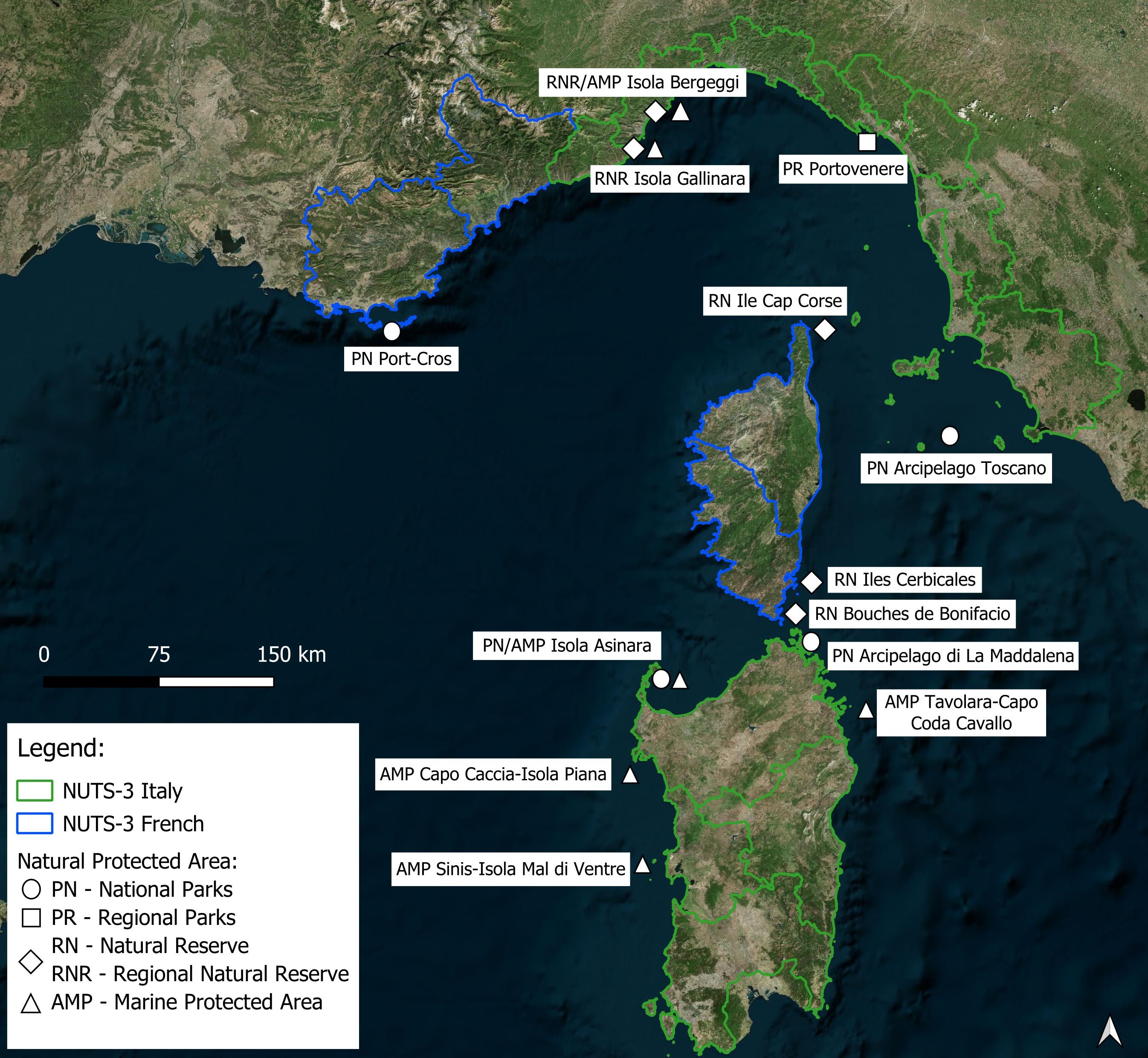
In addition to the two largest islands, this European macroregion includes a number of small islands largely protected by different forms of entities: national parks, regional parks, nature reserves and marine protected areas (Fig. 1; Tab 1). These island territories often share a military or prison past that has made them inaccessible and therefore little exploited and often uninhabited, only to be converted at the turn of the new millennium into “natural paradises” open to tourism in most cases. This has contributed in some cases to the preservation of certain terrestrial and marine habitats, turning them into true environmental heritages worthy of protection.
| Island/Archipelago Name | State (NUTS-1) |
Region (NUTS-2) |
Province/Department (NUTS-3) | Municipality(ies) (LAU) | Form of protection* |
|---|---|---|---|---|---|
| Isola Asinara | Italy | Sardegna | Sassari | Porto Torres | PN dell’Asinara |
| Arcipelago di La Maddalena (La Maddalena, Caprera, Santo Stefano, Spargi e altre minori) | Italy | Sardegna | Sassari | La Maddalena | PN dell’Arcipelago di La Maddalena |
| Arcipelago Spezzino (Palmaria, Tino e Tinetto) | Italy | Liguria | La Spezia | Portovenere | PR di Portovenere |
| Arcipelago Toscano (Elba, Giglio, Capraia, Gorgona, Pianosa, Montecristo, Giannutri) | Italy | Toscana | Livorno/Grosseto | Vari comuni | PN dell’Arcipelago Toscano |
| Arcipelago di Hyères (Port-Cros, Porquerolles, Bagaud) | France | Provence-Alpes-Côte d’Azur | Var | Hyères | PN de Port-Cros |
| Isola Piana | Italy | Sardegna | Sassari | Alghero | AMP Capo Caccia-Isola Piana |
| Isola di Mal di Ventre | Italy | Sardegna | Oristano | Cabras | AMP Sinis-Isola Mal di Ventre |
| Isola Tavolara | Italy | Sardegna | Sassari | Olbia, Loiri Porto San Paolo, San Teodoro | AMP Isola Tavolara-Punta Coda Cavallo |
| Isola di Bergeggi | Italy | Liguria | Savona | Bergeggi | AMP/RNR Isola di Bergeggi |
| Isola Gallinara | Italy | Liguria | Savona | Albenga | RNR Isola Gallinara |
| Isole Giraglia, Finocchiarola a altre minori | France | Corsica | Haute-Corse | Centuri, Ersa, Rogliano | RN Îles du Cap Corse/ Parc naturel marin du Cap Corse |
| Arcipelago Isole Cerbicali (Piana, Pietricaggiosa, Forana e altre minori) | France | Corsica | Corse-du-Sud | Porto Vecchio | RN Îles Cerbicales (Corsica) |
| Arcipelago di Lavezzi (Lavezzi, e altre minori) | France | Corsica | Corse-du-Sud | Bonifacio | RN Bouches de Bonifacio (Corsica) |
1.3 The island of Bergeggi in the context of Ligurian islands and its path to protection
Liguria Region has 350 km of coastline, but only 12 km (3.4 %) are insular, divided into four small islands: Gallinara, Bergeggi, Palmaria and Tino (Fig. 2). These islands reach only 0.05% (2.5 km2) of the regional surface area and, despite their proximity to the coast, represent territories that have always been rather marginal and “hidden”, partly due to the fact that they are rather inaccessible, poor in resources, and poorly usable by recent legislative conditions, as well as by previous military control.
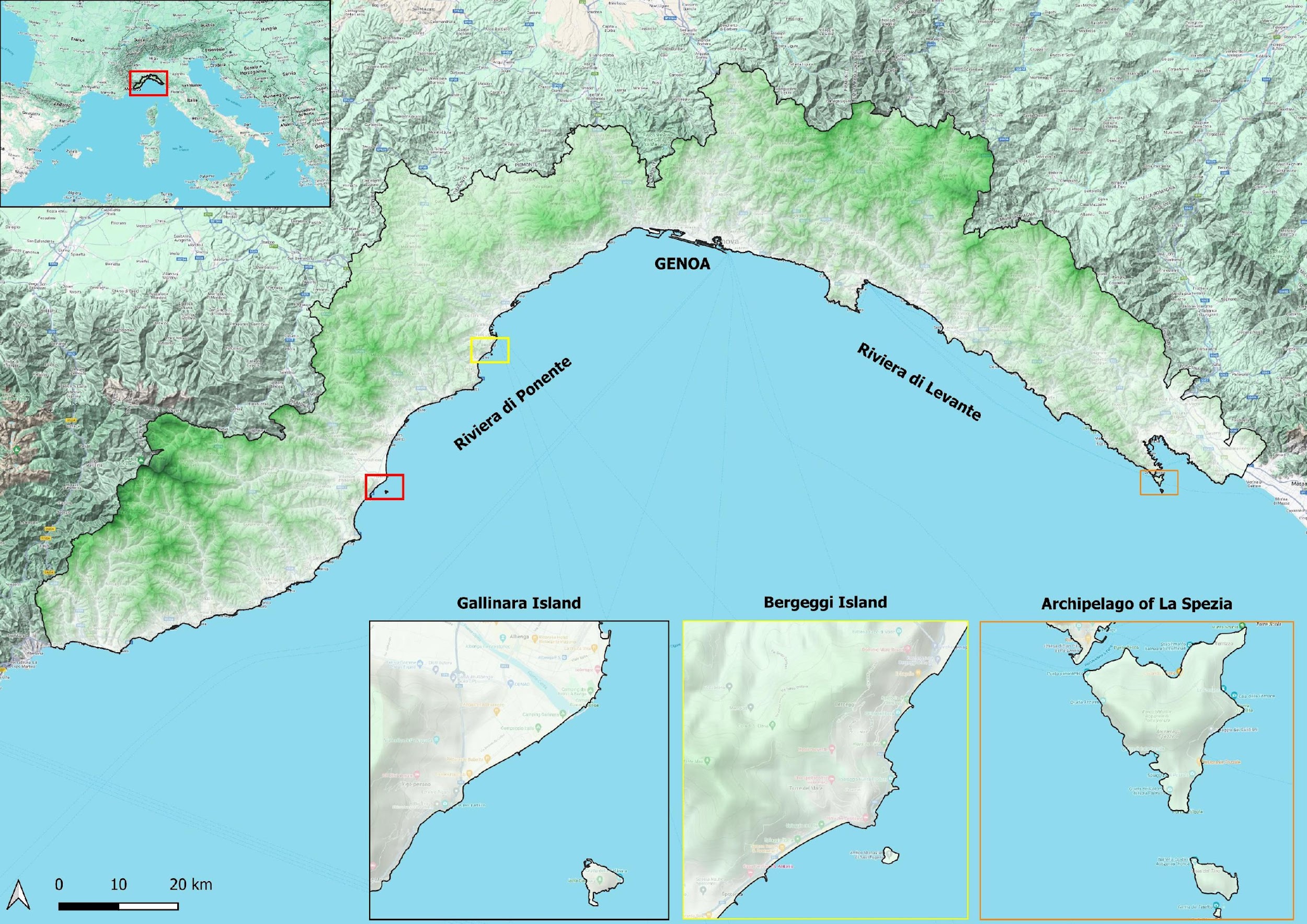
The four Ligurian islands, in fact, all share the transition from militarized to protected areas over the past century, albeit in partially different forms (Lorenzani, Beltrami, 2009). While Palmaria and Tino, located in the province of La Spezia, are both included in the Portovenere Regional Park; Gallinara and Bergeggi, on the other hand, are Regional Nature Reserves. The latter is also surrounded by a Marine Protected Area, while for Gallinara Island such an entity has never been established although it had been assumed in the list of finding areas for MPAs (Barillaro et al., 2002).
As for terrestrial protection, both types are provided for in the italian Legge Quadro (394/91, art. 2) and differ in that regional nature parks are defined as areas “of naturalistic and environmental value, constituting, within one or more neighboring regions, a homogeneous system identified by the natural settings of the places, the landscape and artistic values and the cultural traditions of the local populations”; while regional nature reserves as areas “containing one or more naturalistically relevant species of flora and fauna, or presenting one or more ecosystems important for biological diversity or for the conservation of genetic resources”.
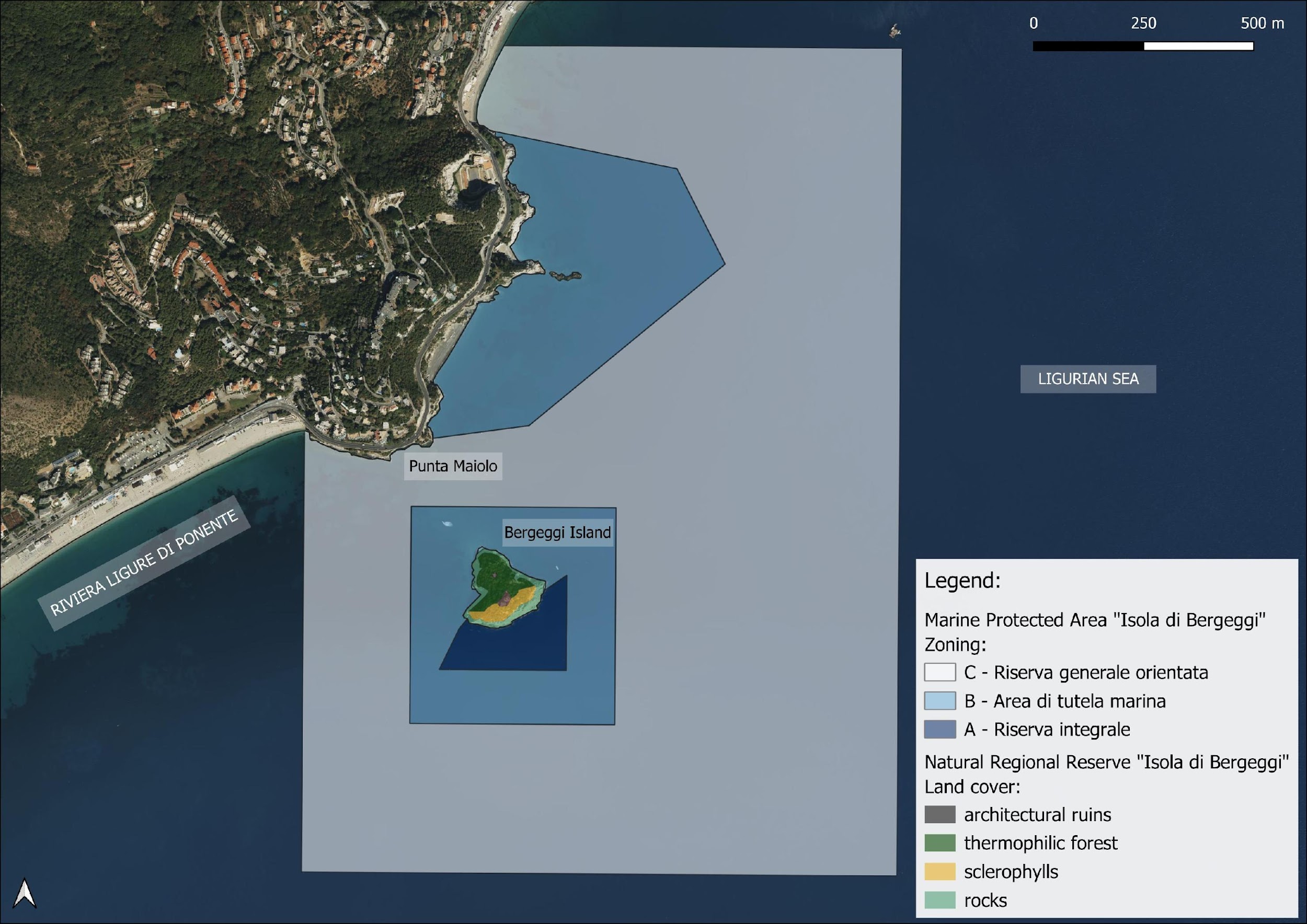
The island of Bergeggi, the specific subject of the focus group, is located in the municipality of Bergeggi, in the province of Savona a few hundred meters from the stretch of northwestern Mediterranean coastline known as the Ligurian Riviera di Ponente. It has an area of 20,476 m2 and reaches a maximum altitude of 53 m above sea level.
In the island, as well as in its “sister” Gallinara, it was the Benedictine monks during the early Middle Ages who left the most marked imprint on the landscape through the building of a small monastery (Bonora et al., 1999; Frondoni, 2015). Once this religious structure was abandoned, due to frequent raids – Saracen first and Barbary pirates later – the island, given its strategic position, was militarized by the Republic of Genoa through a typical watchtower (Regione Liguria, 1999; Penco, 2007).
Observing the land use of the island (Fig. 3), it can be seen that the surface is divided between thermophilic woodland vegetation on the north-facing slope, i.e., the one visible from the coast, and sclerophyll vegetation on the south-facing slope, all surrounded by a rocky strip along the coastline.
An initial survey of the naturalistic emergencies was carried out in the 1970s by Orsino (1975); while, as Rovere et al. (2007) report, between the summer of 2004 and the spring of 2005, underwater bionomic and geomorphological surveys were carried out in the marine stretch in front of the Municipality of Bergeggi and including the seabed included in the MPA. Through this work, the species for which Italian law imposes strict protection measures (Annexes I and II of the Berne Convention, L 503/1981; Annexes II and IV of the Habitats Directive, Presidential Decree 357/1997; Annex II of the Barcelona Convention, L. 175/1999), management (Annex III of the Berne Convention, L 503/1981; Annex V of the Habitats Directive, Presidential Decree 357/1997; Annex III of the Barcelona Convention, L. 175/1999) were surveyed.
According to the information contained in the Natura 2000 Network standard form, the site hosts as many as 9 habitats and 39 species of community interest – between flora and fauna – in a few hectares of area, although part of the site is placed on continental territory. Among the most relevant plant species are: an endemic species (Campanula sabatia) and a species rare in Liguria and close to the northern limit (Anthyllis barba-jovis).
In the second half of the 20th century, the island was subjected to various forms of landscape and environmental protection that further limited the possibility of altering its ecosystem.
First, in 1952, the Ministry of Education – then responsible for “bellezze naturali” (natural beauty) according to the 1939 Bottai Law – placed the landscape constraint of “overall beauty”, which was followed eight years later by the archaeological constraint because «l’Isolotto […] contiene vestigia archeologiche e monumentali, fra cui una torre di epoca imperiale romana e una basilica paleocristiana» (Ministerial Decree of 3/06/1960, constraint code 070122).
Secondly, the island was included in the regional system of protected areas in the form of a Regional Nature Reserve (R.L. No. 10 of 08/27/1985), with the purpose of:
- ensure the protection and redevelopment of the natural environment, historical-cultural values and landscape characteristics of the area concerned, with particular regard to the speleological, archaeological, botanical and geomorphological heritage;
- to promote the knowledge and enjoyment for scientific, cultural and educational purposes of environmental assets in forms compatible with their protection.
By this measure, management was entrusted to the Municipality of Bergeggi, which undertook to:
- adopt and submit to the Regional Council for approval the intervention plans for the educational and scientific use of the Reserve, drawn up after the opinion of the Archaeological Superintendence and the Superintendence for Environmental and Architectural Heritage of Liguria;
- to intervene directly for environmental works related to the protection and enjoyment of the Reserve, particularly with regard to the arrangement and maintenance of the accesses to the caves;
- allocate to the interested parties any contributions arranged by the Region for activities related to the achievement of the objectives of safeguarding the existing naturalistic and environmental values;
- exercise supervision and impose the administrative sanctions provided for in that law.
Ten years later, the island became part of the Natura 2000 Network with two SCIs, one terrestrial and one marine , transformed into SACs in 2017 and 2016, respectively; in whose site sheet the following scientific qualities are reported: presence of dolomite outcrops of S. Pietro dei Monti with algal structures and pelitic interlayers; evidence of historical-archaeological importance (St. Eugene’s monastery and watchtower); presence of fragments of Mediterranean habitats of considerable interest, endemics and other species protected by international directives/conventions.
More recently, the Marine Protected Area Isola di Bergeggi was established by the state with Law No. 206 on 5/09/2007 with the aim of protecting, among other naturalistic peculiarities, one of the richest coralligenous populations in the Mediterranean, despite the fact that most of them are actually outside the MPA limits (Parravicini et al., 2007), but also to enhance the natural heritage and promote the sustainable use of resources.
Since the MPA adjoins a terrestrial protected natural area, management was assigned to the entity responsible for the latter, in compliance with the principles of Integrated Coastal Zone Management (ICZM) provided for by the EU and the Italian Legge Quadro (Art. 19) and already theorized by Vallega (1999), among others.
The founding law also stipulated that if it was indispensable for the implementation of the plans, the Municipality of Bergeggi could also provide by expropriation for public utility of the land identified for protection. The island is actually still private but negotiations have begun to make it visitable. Similar to the case of Gallinara, in recent years the local government, in agreement with the regional government, has in fact decided to undertake a tourism enhancement project. The plan envisages greater usability for the public while contingenting access flows to the island, particularly favoring non-impact water sports. According to the report of the Bergeggi Municipality’s beginning of term budget (2021-2025), preparatory work for opening to the public was supposed to be completed in 2023, but to this day the island is closed to the public.
In fact, one of the recurring problems is the shortage of personnel in the MPA as well as in the RNR, which is solved temporarily with seasonal scholarships, internships, or collaborations with research institutes and/or training institutions. A situation that certainly does not help in the actions of surveillance and monitoring of habitats, protection and enhancement of biodiversity, and with a view to making the MPA more and more established not only as an institution suitable for the protection of natural heritage but as a real engine for the sustainable development of the territory and the local community.
Despite this, from 2007 to the present, the MPA has seen its ability to attract and invest economic resources from the Ministry of the Environment or the European Union in the territory increase: through participation and involvement in regional or cross-border cooperation projects (Bergeggi Municipality, 2021). In fact, the entity has been involved in a number of European projects such as Re-life, aimed at reintroducing Patella ferruginea in the three Ligurian Marine Protected Areas, and NEPTUNE (Underwater Natural and Cultural Heritage and Sustainable Management of Recreational Diving) - where the AMP Isola di Bergeggi has been identified by Regione Liguria as the site for the preparation of a sea trail dedicated to swimming, snorkeling, kayaking and sup, called “Blue Trail of Bergeggi”.
Finally, in the next few years, in line with the “30x30” indications of the European Biodiversity Strategy (EU, 2020), the enlargement of the MPA is planned, although in 2022 an element of contrast – or “organizational incompatibility” to use a term of Vallega (1999) – has arisen with respect to the latter proposal. This is the plan to install a regasifier in front of Vado Ligure, i.e., the municipality adjacent to Bergeggi, given the Russia-Ukraine crisis that has caused a reorganization of European energy geopolitics. A hypothesis for which even the Italian Superior Institute of Environmental Protection (ISPRA) has expressed doubts, however, precisely because of the very presence of the MPA, and rather contested by the local community, which has formed a protest movement about it.
In September 2023, fifteen thousand people formed a human chain along the coast from Savona to Vado. This form of protest was repeated in July 2024 and seems to have had results. Since then, the movement has grown and spread to municipal administrations and the new regional council, which, despite being supported by the same parties as the previous one, decided on a unanimous motion committing the region to block the transfer of the Golar Tundra ship to its previously planned destination (Forti, 2025).
2. Materials And Methods
2.1 Vulnerability and resilience analysis of Bergeggi Island through a participatory methodology
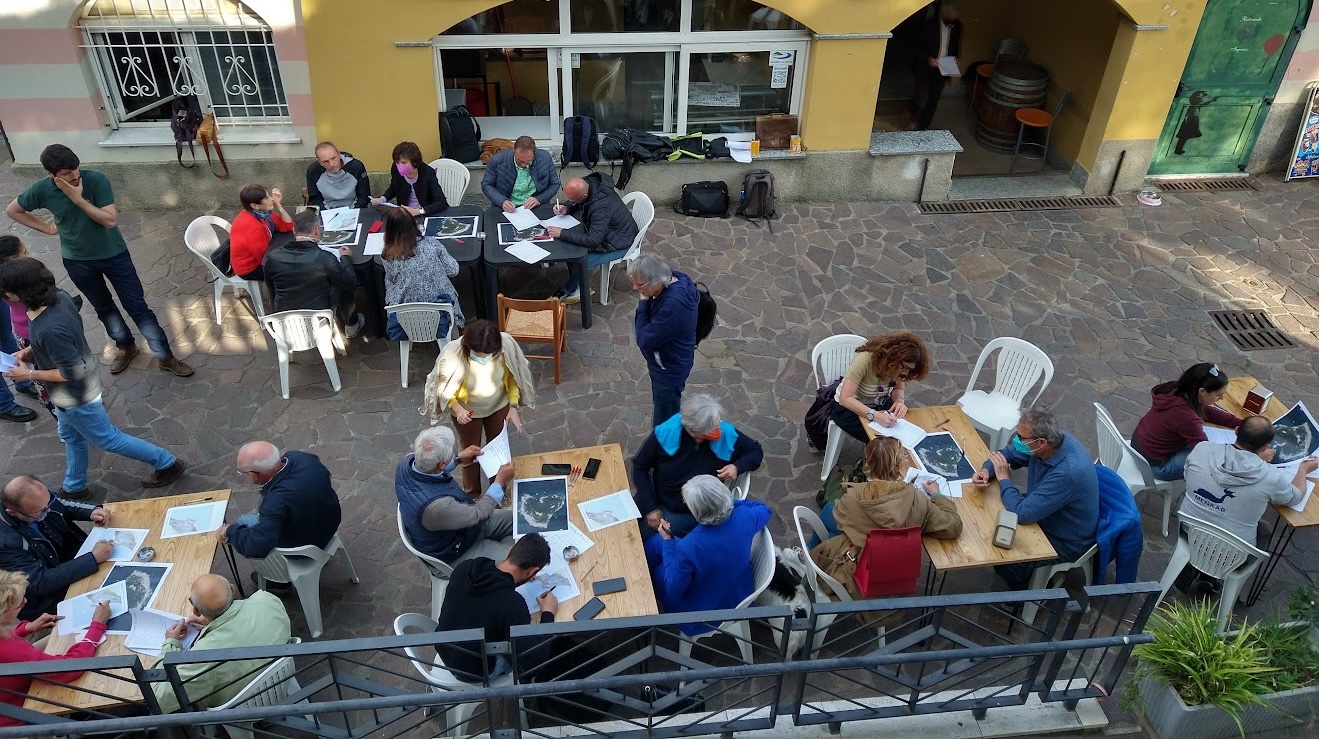
The focus group aimed at the perceptual analysis of vulnerability and resilience was conducted by the economic and political geography research group at the University of Genoa, in collaboration with the Municipality of Bergeggi and the Isola di Bergeggi Marine Protected Area on May 3, 2022 at the Circolo Bergeggino in the municipality of Bergeggi (Fig. 4), and consisted of the guided completion of a form with 14 questions, 6 of which were demographic and 8 specific to the workshop topic (Tab. 2).
| a) Registry type questions | ||
|---|---|---|
| 1 | Age | Choice among categories |
| 2 | Gender | Choice among categories |
| 3 | Qualification | Choice among categories |
| 4 | Job | Choice among categories |
| 5 | Role | Open response |
| 6 | Municipality of residence | Open response |
| b) Specific questions | ||
| 1 | How would you define the vulnerability of Gallinara Island? What issues are you thinking about? | Open response |
| 2 | Look at the picture and list in the table the elements, places, phenomena and/or activities that you think are most vulnerable. | Up to a maximum of 10 responses |
| 3 | List in the table the 3 elements, places, phenomena and/or activities where you think interventions and strategies would need to be implemented to reduce vulnerability. | Up to a maximum of 3 responses |
| 4 | How would you define the resilience of Bergeggi Island, with respect to its sustainability and usability for current and future generations? | Open response |
| 5 | List in the table below the 3 interventions/strategies that you think would need to be implemented to increase the resilience of Gallinara Island. | Up to a maximum of 3 responses |
| 6 | Are you aware of any initiatives, interventions, or strategies already implemented to increase the Island’s resilience? | Up to a maximum of 3 responses |
| 7 | How would you define the official communication regarding the Regional Nature Reserve? | 1 to 3 keywords |
| 8 | Try drawing the boundaries of the Regional Nature Reserve on the map. | Paper drawing |
There were 38 participants – including tour operators, local administrators, association representatives, ordinary citizens and tourists – equally divided between males and females (18 and 20) and between age groups: 5 (18-35), 4 (36-45), 9 (46-55), 8 (56-65), 11 (over 65). Participants came from 40% from the municipality itself, 47% from neighboring municipalities, and the remainder from other parts of Italy. They were reached through the communication tools of the AMP and the Municipality or, in some cases, through personal invitations, seeking to involve as many types of stakeholders as possible.
2.2 Comparative analysis of small protected islands in the northwestern Mediterranean
As for the subsequent comparative analysis, all island protected natural areas located in the cross-border area between Italy and French “Interreg Marittimo” were identified. After that, the cases of permanently inhabited islands were discarded as this characteristic implies a first major difference from the in-depth case study. Thus, of the 13 cases listed above, only 9 were compared in addition to the case of Bergeggi: Asinara Island, Arcipelago Spezzino, Piana Island, Mal di Ventre Island, Tavolara Island, Gallinara Island, Capo Corso Islands, Cerbicali Islands and Lavezzi Archipelago. The La Maddalena Archipelago, Tuscan Archipelago and Hyères Archipelago were then excluded from benchmarking, even though not all of their component islands are inhabited.
After that, a qualitative-quantitative analysis was carried out aimed at assessing the efficiency of protected area management bodies overall through an evaluation grid consisting of six themes (Tab. 3), which relate in various aspects to the resilience and/or vulnerability of the small islands they protect. All six themes were weighted equally in the benchmarking, with emphasis placed less on individual numeric scores and more on the overall hexagonal profile formed in the radar chart, in keeping with the criticism of purely quantitative research cited in the text.
| # | Category | Description |
|---|---|---|
| 1 | Accessibility | How many and which are open to the public? If they are, do they have an access limit? |
| 2 | Funding | What funding do management bodies receive (state/region/municipalities + European projects)? |
| 3 | Management | What management tools and elements do management bodies have (dedicated staff, management plans, environmental education activities)? |
| 4 | Web presence | How well known on the web and social media are the management bodies? |
| 5 | Biodiversity Protection | How many habitats/species of community interest are protected? |
| 6 | Economic activities | What economic activities are planned on the island or in the protected stretch of sea? |
3. Results and discussion
3.1 Results of the focus group
As noted above, the analysis conducted followed a vulnerability/resilience logic, two concepts that were explained to the participants before filling out the forms, trying not to bias their views.
All open-ended responses were manually coded by extracting key terms and grouping synonymous words to form consistent thematic categories.
On the vulnerability side, the elements/places considered most at risk (Fig. 5A), which were fundamental to then defining resilience practices, were found to be flora and fauna, followed by archaeological remains and the seabed; while the activities considered most influential for the vulnerability of the island (Fig. 5B) were found to be: the excessive presence of seagulls whose guano damages the flora and rocks of the reef, coastal erosion, illegal fishing and uncontrolled tourism, particularly nautical tourism.
Compared to the SAC sheet compiled in 1995, therefore, the only element not mentioned among the site’s vulnerabilities is water pollution, while the problem of illegal fishing has been added.

With regard to resilience, on the other hand, questions were asked related to knowledge of initiatives introduced to improve it, as well as proposals to mitigate the vulnerability of the elements mentioned above.
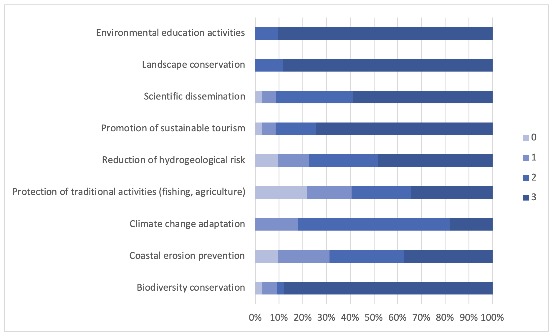
Regarding the latter, in particular, they were asked to score (from 0 = not at all to 3 = very important) a number of possible interventions. Among these, those found to be most important were: environmental education activities (mean score: 2.91), landscape and biodiversity preservation (2.88 and 2.76) and promotion of sustainable tourism (2.63); while the least important action was found to be the preservation of traditional activities (fishing and agriculture): 1.72 (Fig. 6).
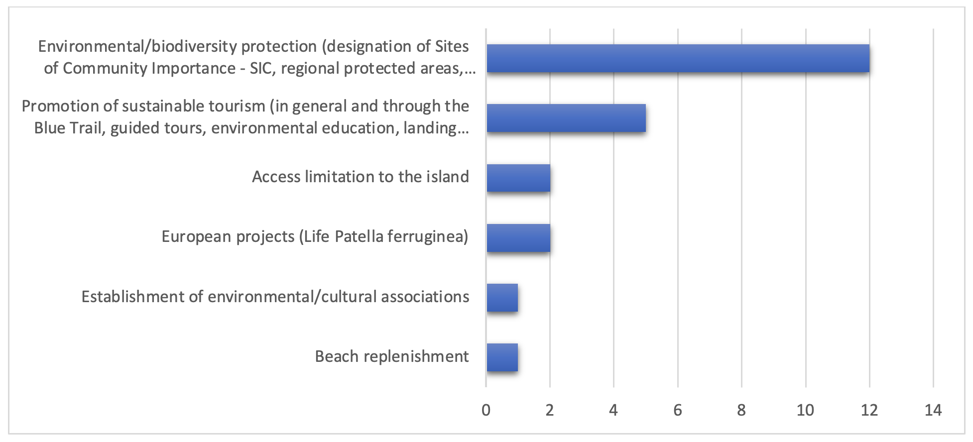
On the other hand, when asked about knowledge of actions already carried out to improve resilience (Fig. 7), more than half referred to safeguarding the environment and biodiversity through the various forms of protected areas: establishment of SCIs/SACs, regional protected areas, marine area. While one in four mentioned sustainable tourism activities: guided tours, environmental education, etc.
Finally, the position with respect to the possible enlargement of the protected area also envisaged in accordance with the new European Biodiversity Strategy was investigated. Seventy-six percent of the participants were in favor, 13 percent against, and 11 percent had no opinion. Contextually, overall satisfaction with the activities carried out in the first 15 years of the MPA Management Authority’s existence was investigated. In more detail, participants were asked whether the MPA has positively, negatively, or not at all affected the environment, the economy, and the local community (Fig. 8): only 8% felt that there has been no improvement; another 8% did not express an opinion; while the remaining 84% claimed that there has been an improvement: environmentally (79%), economically (26%), and socially (13%).
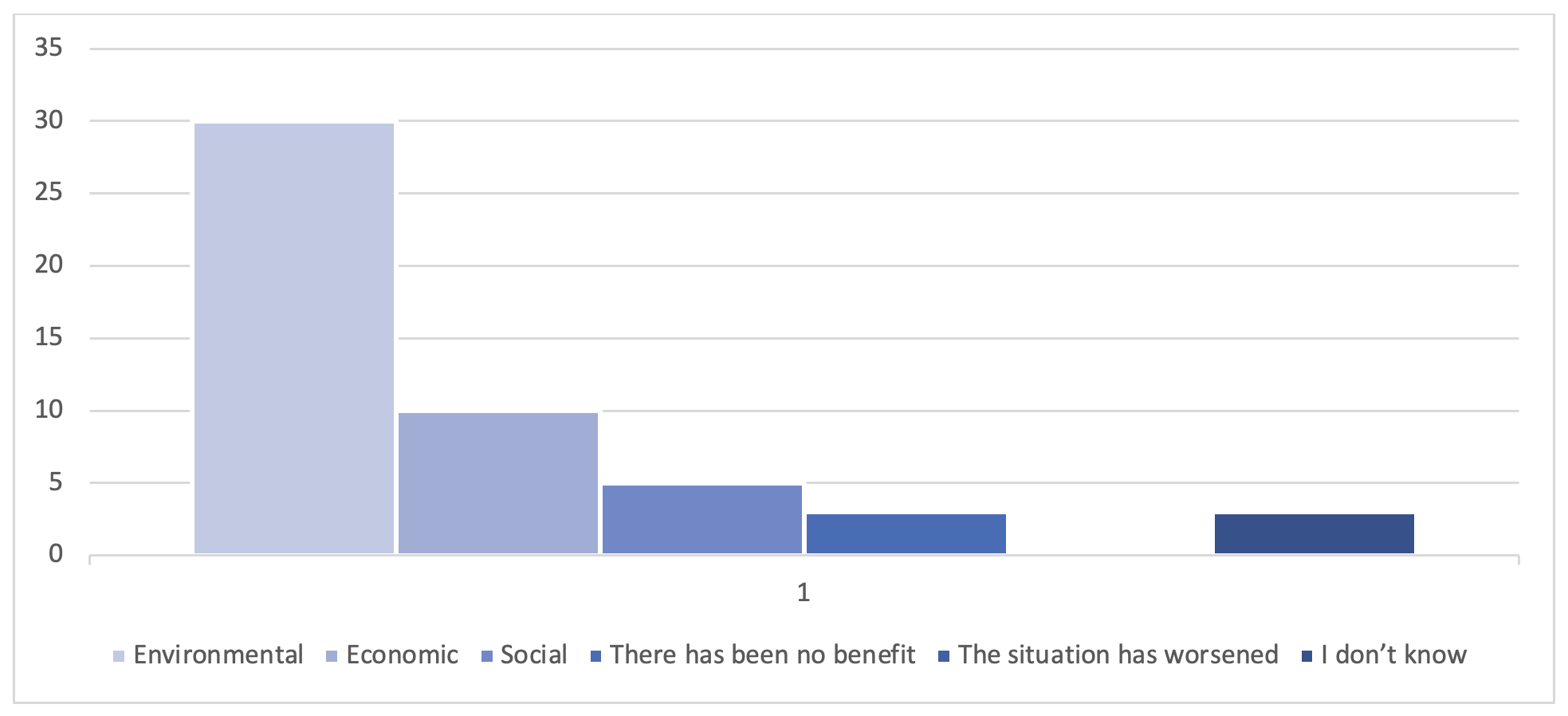
This result confirms a rather widespread thought, but one that is not always confirmed by reality, namely that protected areas-not only marine ones, whose role in territorial development is rather debated in the literature (Rovere et al., 2009)-are primarily a tool for improving environmental conditions and in only marginal form for improving socioeconomic conditions (Brocada, 2023).
Indeed, several studies also report direct or indirect economic benefits following the establishment of MPAs. Direct benefits, also referred to as “market” benefits (Davis et al., 2019), include increased fishery profitability and spillover of fish biomass from protected areas to surrounding fishing grounds; while indirect benefits consist mainly of increased tourism and ecosystem services such as the role of Posidonia in mitigating coastal erosion, thus avoiding expenditures to find artificial solutions to solve the problem, or carbon storage of protected plants in the protected natural area, and so on.
To make people perceive the fundamental role that protected areas also play in the development of the territory and social welfare, one of the most important tools today is certainly that of information technologies, particularly social portals: Facebook and Instagram in primis, but also official websites (Mangano, Ugolini, 2017). Therefore, in the comparative analysis that follows, attention was also paid to the web presence of the entities that protect the territories studied.
3.2 Results of benchmarking analysis
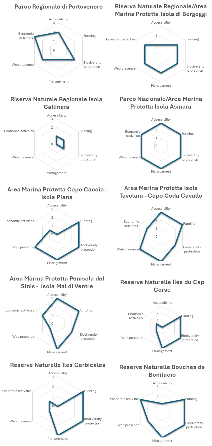
According to the web search carried out, the ten protected natural areas compared show considerable inhomogeneity depending on the region they belong to, thus on the type of management body. The benchmarking evaluated each island’s protected-area management across the six thematic listed before. For each theme, we assigned an integer score from 0 to 3, determined against the sub-criteria listed in the table 4. For example, Accessibility was scored from 0 (completely forbidden) to 3 (fully open to the public with no restrictions), Funding from 0 (no dedicated funds) to 3 (regular state/regional budgets plus European project support). The resulting score profiles for each island were plotted as radar charts to visually compare overall management activity and highlight relative strengths and weaknesses.
In particular, public accessibility is allowed to all freely in three cases (Tavolara, Mal di Ventre, Asinara), while in three other cases there are territorial limits: that is, in the case of archipelagos where not all islands are accessible (Spezzino Archipelago, Lavezzi Archipelago).
On the two islands in western Liguria (Gallinara and Bergeggi), access is allowed only to property owners, as well as, clearly, to insiders. Finally, in three cases access is totally forbidden (Isola Piana, Cerbicali Islands and Cape Corso Islands).
Economically, management bodies almost always have state, regional and European funding through participation in projects. As far as management is concerned, however, almost all NPAs have a plan or regulations-except for the RNR Gallinara Island-and at the same time carry out environmental education, although, there is not always staff totally dedicated to the NPA, especially in the case of small territories.
As highlighted above, an increasingly important tool is the web presence of NPAs, particularly for disseminating environmental protection and education efforts, rather than merely attracting tourism especially through social media (Mangano, Piana, 2021). In this regard, only 7 out of 10 NPAs have an official website, 8 out of 10 have a Facebook page, and 4 out of 10 have an Instagram page. Finally, 6 NPAs are present on the best-known travel review portal: Tripadvisor, also used, moreover, by Carboni and Pungetti (2018) to identify tourists’ perceptions of crowding with a view to identifying the carrying capacity of some beaches on Asinara Island.
Coming to the primary aspect of NPAs, namely the protection of biodiversity, all the protected areas compared include Natura 2000 Network sites within them, while from the perspective of strict protection, only 6 have terrestrial integral reserves and 8 marine integral reserves within them.
In conclusion, with respect to economic activities, almost all islands offer the opportunity to practice any of them: only at the RNR Gallinara Island there is no activity, while in all other cases primary activities are carried out within the protected area (agriculture and/or fishing ). In 7 cases there is also provision for outdoor sports activities, sometimes with guided tours by licensed professionals. Finally, only in three islands are there catering or hospitality facilities (Asinara, Palmaria and Lavezzi).
| Categories | Benchmarking [0–3] | ||||
|---|---|---|---|---|---|
| 1 | Accessibility | Forbidden | Prohibited except owners and insiders | Yes partially | Yes totally |
| 2 | Funding | Municipality | Region | State | EU Projects |
| 3 | Management | Absent | Dedicated or associate staff (in addition to the director/manager) | Plan or Regulation | Environmental education |
| 4 | Web presence | Web Site | Facebook page | Instagram page | Tripadvisor page |
| 5 | Biodiversity Protection | Natura 2000 | NPA | Terrestrial integral reserve | Marine integral reserve |
| 6 | Economic activities | Absent | Agriculture and/or Fisheries | Foodservice and hospitality | Guided excursions and/or outdoor activities |
The overall result of the analysis was represented with a radar graph for each island NPA (Fig. 9), in which it was tried to highlight the efficiency of the management entities with respect to resilience issues. Depending on the width and shape of the polygon that then formed the paired National Park/ Marine Protected Area (or the case of Asinara Island) - managed by a single body as required by ICZM - was the best management system, getting maximum points in all areas.
It is also true that it is the largest island among those analysed, so tourist flows are much less concentrated than in other cases where total opening could potentially damage the ecosystem and the visitor experience itself.
Follow the three Sardinian AMP areas Capo Caccia-Isola Piana, Isola Tavolara-Capo Coda Cavallo and Penisola del Sinis-Isola di Mal di Ventre, which differ from each other only for the poor web presence of Mal di Ventre, while Isola Piana mainly pays the inaccessibility, although understandable given the morphological peculiarities of the place.
Instead, the Ligurian NPAs are less efficient; in particular, the RNR Isola Gallinara does not reach sufficient scores in any area being in fact a territory forgotten for years by the public administration. Only recently has it returned to the spotlight in view of a enhancement project financed by the EU and the Region that also includes research by the University of Genoa, as well as the construction of museum structures on the island.
Finally, the three Corsican nature reserves show a similar graphic structure, although managed almost in the same way, namely by the Office de l’Environnement de la Corse. This body, dependent on the Collectivité Territoriale de Corse, differentiates the reserves of this region from all the other French reserves on the continent because of the autonomy granted by the French Republic to Corsica in certain administrative areas, given the strong feeling of independence that characterizes the region (Farinelli, 2019).
For some years the islands of Capo Corso, moreover, have merged into the Parc Naturel Marin du Cap Corse et de l’Agriate, a type of body that has no equivalent in Italy and that brings together several nature reserves under one body, albeit always in collaboration with the OEC mentioned above.
It should be noted, in conclusion, that projects are also under way at AMP Isola di Bergeggi to improve the efficiency of the body, despite the problems identified in the previous paragraph, as well as the lack of regional policy attention, also confirmed by the scarcity of funds and resources allocated to some protected areas.
The results of the comparative analysis broadly reflect the issues identified in another study of the same area, which focused solely on terrestrial nature parks and explored socio-environmental conflicts in greater depth (Brocada, 2025). In that study, one of the best practices was found to be the French system of establishing regional parks, which can only continue to exist if the objectives agreed upon in the “Charte du Parc” are respected, unlike in Italy, where they are established by law and only afterwards are their boundaries and objectives defined. Furthermore, the graphic, communicative and institutional homogeneity of the French model is clearly superior to the heterogeneity of Italian protected area systems, which differ from region to region and are often unclear even at the state level.
The coexistence between Municipality, Region, State and European Union, generally reveals a fragmented system of governance and the lack of homogeneity in the forms of protection of almost identical territories, often slowed down by overlapping competences and not always converging objectives. The financial resources allocated at central level are sometimes difficult to translate into sufficient personnel on the ground, while the EU directives on the Natura 2000 network may collide with municipal town planning plans. This “fragmentation effect” not only slows down decisions but also fuels resentment among the different actors, who perceive conservation as a constraint imposed top-down rather than as a shared project. In fact, NPAs are too often governed in a centralized and verticist way for the pursuit of quantitative objectives which often lead to neglect of quality and social equity.
4. Conclusions
As noted by Salustri and Apolloni (2021), the small Mediterranean islands constitute a mosaic that is not easy to reconstruct. In particular, the analysis, although it only looked at one NPA out of the many listed, reveals that the protected small islands are territories in which ecological, economic and social considerations are intertwined in a far from linear way. Behind the curtain of European and national regulations lie profoundly different visions of the future: on the one hand, there are those who push for a more decisive opening to tourist flows in order to support the local economy; on the other, there are real fears about the risk of coastal erosion, loss of biodiversity and impairment of cultural heritage, problems often made incomprehensible by the people because of the terminology used.
The concept of resilience itself has become central in numerous international regulatory instruments, but its widespread use is accompanied by a lack of clarity in terms of definition, operation and application. Rather than being a flaw, this ambiguity proves useful in the political sphere, where it allows institutions and governments to adopt the term without questioning its regulatory implications or the underlying inequalities (Cutter, 2016). At the same time, however, it may be used rhetorically and technocratically in global and local governance contexts, as has already happened with other concepts that have been “in vogue” in recent decades, such as sustainability (Weichselgartner, Kelman, 2014), but also ecological transition, green economy, and so on.
For the same reason, cost-benefit analyses, such as that proposed by Wahyudin et al. (2025), appear to be limiting in capturing the actual impacts of protected areas and pay little attention to the social and perceptive dimension, also because much of the benefits are difficult to quantify in monetary terms, as has already been observed in the past (Dixon, Sherman, 1991; Figuières, Salle, 2014; Davis et al., 2019). Finally, many of the available analyses are based on a limited number of criteria and indicators, often chosen for reasons of practicality rather than representativeness (Hosseini et al., 2021).
Also at global level, the management of NPAs seems to present the same challenges all over the world: finding a balance between different sectors that rely on coastal and marine resources with different objectives, sometimes mutually incompatible. In addition, NPA policies are often replicated from other locations without taking into account local contexts where actors may have different needs, or where the ecosystem is more resilient to greater pressures (Yoppie, 2025).
It is clear that the contemporary economy of these places can only be mainly linked to tourism, which in the last century has accompanied, and gradually replaced, primary activities such as agriculture, fishing or even the extraction of raw materials. These territories, however, have a strong vulnerability and for this reason they need a careful planning of tourist activities, possibly introducing limitations to the number of daily visitors, although often unwelcome by stakeholders (Cadoret, 2021). It is important to use new monitoring technologies, as proposed by Rogowski (2025), to better understand the problem of overtourism and take targeted action. On the other hand, the taxes recently introduced in various areas affected by overtourism are ineffective and deeply socially unjust, as they do not limit tourist flows but only affect the less affluent sections of the population.
The challenge of enhancing tourism on the small islands of the north-western Mediterranean, in particular those of Liguria, must lie in avoiding the repetition of past mistakes made in previous decades in other smaller islands where overtourism has led to negative externalities such as excessive solid waste production, pollution, biodiversity loss, exploitation of energy and water resources, pollution caused by the emission of vehicles (Carboni, Pongetti, 2018). A development model misaligned with land conservation agencies, which are too often weakened precisely to limit their ability to act, would probably lead to further exploitation by tourism entrepreneurs in a neoliberal sense (Chandler, Pugh, 2020). In summary, two key principles to enhance the resilience of these small islands are the establishment of visitor thresholds and the integration of habitat protection into local economic strategies, as already observed by Zoppi (1993). It is essential, however, that local communities are involved in the process of identifying shared objectives according to a multistakeholdership perspective where the choices regarding development are aimed at satisfying a plurality of sometimes conflicting interests (Salustri, Apolloni, 2021).
In this sense, the findings of this study suggest that future policy efforts should focus on enhancing institutional coordination and reinforcing the operational capacity of local governance structures. Strengthening the resilience of small islands requires long-term investments in both financial and human capital, as well as the establishment of participatory governance mechanisms that can align top-down conservation objectives with bottom-up needs and knowledge. Rather than adopting uniform and technocratic approaches, policies should be rooted in local specificities, sensitive to cultural landscapes, and responsive to the expectations of nearby communities.
Furthermore, communication strategies should be seen as central pillars of protected area governance. Increasing the visibility and accessibility of protected areas through digital platforms, transparent reporting, and citizen science initiatives may foster trust, improve accountability, and enhance the perceived legitimacy of conservation strategies.
Although the focus group methodology did not engage a large number of participants and thus carries an inevitable risk of interpretive bias by the author, future research will aim to apply and refine this analytical framework across other protected island areas, currently examined only through secondary data, with the goal of fostering a more comparative and operational understanding of vulnerability and resilience in the Mediterranean context.
References
- Barillaro, B., Gioffrè, P., Palermiti, S., Taverniti, D., 2002. Indagine comparativa sulla gestione delle Aree Marine Protette, in: Fallanca De Blasio, C. (Eds.), Parchi naturali. Iiriti Editore, Reggio Calabria, pp. 263-268.
- Bartaletti, F., 2009. Le aree metropolitane in Italia e nel mondo. Il quadro teorico e i riflessi territoriali. Bollati Boringhieri, Torino.
- Binley, A. D., Proctor, C. A., Pither, R., Davis, S. A., Bennett, J. R., 2021. The unrealized potential of community science to support research on the resilience of protected areas. Conservation Science and Practice. 3(5): e376.
- Bonora, V., Calzolari, E., Codebò, M., De Santis, H., 1999. Gli orientamenti delle chiese del Caprione (SP) e dell’isola di Bergeggi (SV). Atti del XVIII Congresso Nazionale di Storia della Fisica e dell’Astronomia, Milano, 1-9.
- Brocada, L., 2023. Sociopolitical conflicts on the establishment of protected natural areas: The case of Portofino National Park (Genoa, North-West Italy). AIMS Geosciences, 9(4): 713-733.
- Brocada, L. 2025. Geografia dei parchi naturali costieri. Conflitti socio-ambientali nel Mediterraneo nord-occidentale. Guerini, Milano.
- Cadoret, A., 2021. Conflicts and acceptability of visitation management measures for a marine protected area: The case of Porquerolles, Port-Cros National Park. Ocean & Coastal Management, 204: 105547.
- Camilleri, A., Colombini, I., Chelazzi, L. 2012. Evolution and management of landscapes on Mediterranean minor islands: case studies from the Tuscan Archipelago (Italy) and Comino (Malta), in: Conrad, E., Cassar, L. (Eds.), Evolution and management of landscapes on Mediterranean minor islands. Institute of Earth Systems, University of Malta, pp. 169-203.
- Carboni, D. Congiatu, P., De Vincenzi, M., 2015. Asinara National Park. An Example of Growth and Sustainability in Tourism, Journal of Environmental and Tourism Analyses. 3(1): 44–60.
- Cassola, F., 1996. Problemi di protezione dell’ambiente naturale nelle piccole isole circum-sarde. Biogeographia - The Journal of Integrative Biogeography, 18(1): 667-682.
- Chandler, D., Pugh, J., 2020. Islands of relationality and resilience: The shifting stakes of the Anthropocene. Area. 52(1): 65-72.
- Corbau, C., Rodella, I., Congiatu, P., Simeoni, U., Carboni, D., 2018. Usi e conflitti nel Parco Nazionale dell’Asinara (Italy), in Benincasa, F. (Eds.), Seventh International Symposium: monitoring of Mediterranean Coastal Areas: Problems and Measurement Techniques (Livorno, June 19-21, 2018, Firenze University Press, Florence, pp. 367-381.
- Cumming, G.S., Allen, C.R., Ban, N.C., Biggs, D., Biggs, H. C., Cumming, D.H., De Vos A., Epstein G., Etienne M., Maciejewski K., Mathevet R., Moore C., Nenadovic M., Schoon, M., 2015. Understanding protected area resilience: a multi‐scale, social‐ecological approach. Ecological Applications, 25(2): 299-319.
- Cutter, S.L., 2016. Resilience to What? Resilience for Whom?. The Geografical Journal, 182: 110-113.
- Davis, K.J., Vianna, G.M., Meeuwig, J.J., Meekan, M.G., Pannell, D.J. 2019. Estimating the economic benefits and costs of highly‐protected marine protected areas. Ecosphere, 10(10): e02879.
- Di Matteo, G., 2019. Immigrazione e turismo in un contesto microinsulare. Sperimentazioni di responsabilità turistica a Lampedusa, in: Salvatori, F., (Eds.), L’apporto della Geografia tra rivoluzioni e riforme, Atti del XXXII Congresso Geografico Italiano (Roma, June 7-10, 2017), pp. 2927-2933.
- Divacchio, G., 2009. Le aree protette marine in Liguria, in Burlando M. (Eds.), Il sistema regionale delle aree protette della Liguria. Edizioni ETS, Pisa, pp. 93-106.
- Dixon, J.A., Sherman, P.B., 1991. Economics of Protected Areas, Ambio, 20(2): 68-74.
- European Commission, 2020. EU Biodiversity Strategy for 2030. Bringing nature back into ourlives. Bruxelles.
- Farinelli, M.A., 2019. Corsica e Sardegna: due isole vicine o un arcipelago invisibile?, in: Salvatori, F., (Eds.), L’apporto della Geografia tra rivoluzioni e riforme, Atti del XXXII Congresso Geografico Italiano (Roma, June 7-10, 2017), pp. 2897-2903.
- Figuières, C., Salles, J-M., 2014. Non-comparabilité et incommensurabilité. Réflexions sur l’évaluation de la nature, in R. Chenorkian, S. Robert (Eds.), Les interactions hommes-milieux. Questions et pratiques de la recherche en environment, Quæ Éditions, Versailles, pp. 163-179.
- Forti, M., 2025. L’ombra del nuovo rigassificatore agita ancora la Liguria, Internazionale, 5.3.2025, https://www.internazionale.it/reportage/marina-forti/2025/03/05/rigassificatore-vado-ligure-savona.
- Frondoni A., 2015. Culto e reliquie tra isole e terraferma: l’isola di Bergeggi (Liguria), in: Martorelli, R., Piras, A., Spanu, P.G., (Eds.), Isole e terraferma nel primo cristianesimo. Identità locale ed interscambi culturali, religiosi e produttivi. PFTS University Press, Cagliari, pp. 255-266.
- Gallia, A., 2012. La valorizzazione dei beni culturali e ambientali per lo sviluppo delle isole minori Italiane. Rivista giuridica del Mezzogiorno. 26(4): 929-962.
- Gambino, R., 1997. Conservare, innovare. Paesaggio, ambiente, territorio. UTET, Torino.
- Halik, A., Verweij, M., Schlüter, A. 2018. How Marine Protected Areas are governed: a cultural theory perspective. Sustainability, 10(1): 252.
- Hosseini, S., Oladi, J., Amirnejad, H., 2021. The evaluation of environmental, economic and social services of national parks, Environ Dev Sustain 23: 9052-9075.
- Lampreu, S., 2019. Tra sostenibilità ambientale e istanze economiche e sociali. Il contributo delle Aree Marine Protette allo sviluppo territoriale, in Mariotti, G., Camerada, M.V., (Eds.), Area Marina Protetta Capo Caccia – Isola Piana. Analisi geo-economica della filiera del pescato. Tab Edizioni, Roma, pp. 23-32.
- Lorenzani, F., Beltrami, F., 2009. Il lungo percorso delle aree protette della Liguria, in: Burlando, M., (Eds.), Il sistema regionale delle aree protette della Liguria. Edizioni, ETS, Pisa, pp. 15-52.
- Malatesta, S., Cavallo, F., 2019. Studi insulari in geografia: oltre l’isolamento e la vulnerabilità? Introduzione, in: Salvatori, F., (Eds.), L’apporto della Geografia tra rivoluzioni e riforme, Atti del XXXII Congresso Geografico Italiano (Roma, June 7-10, 2017), pp. 2893-2895.
- Malatesta, S., 2021. Uniche, remote e vulnerabili: il ‘bisogno di natura’ nella geo-grafia delle regioni insulari. Rivista Geografica Italiana, 128(2): 37-52.
- Molinari, A., Tunesi, L., 2003. Observations on fish assemblages of the coastal area of Bergeggi (Western Ligurian Sea), Atti del XV Congresso AIOL, 16, pp. 155-161.
- Mangano, S., 2007. Turismo e tempo libero nelle aree naturali protette. Carocci, Roma.
- Mangano, S., Piana, P. 2021. Narrare e costruire il paesaggio per immagini: i parchi liguri tra divulgazione e percezione, in: Castiglioni, B., Puttilli, M., Tanca, M., Oltre la Convenzione: Pensare, studiare, costruire il paesaggio vent’anni dopo. Società di Studi Geografici, Firenze, pp. 339-353.
- Mangano, S., Ugolini, G.M., 2017. Nuove tecnologie e smart map per un turismo urbano e una mobilità intelligente. Bollettino dell’Associazione Italiana Cartografia. 160: 8-21.
- Orsino, F., 1975. Flora e vegetazione delle isole Gallinara e Bergeggi: (Liguria occidentale), Webbia, 29(2): 595-644.
- Palomo, I., Martín-López, B., Alcorlo, P., Montes, C., 2014. Limitations of protected areas zoning in Mediterranean cultural landscapes under the ecosystem services approach. Ecosystems. 17: 1202-1215.
- Parravicini, V., Donato, M., Rovere, A., Montefalcone, M., Albertelli, G., Bianchi, C.N., 2007. Indagine preliminare sul coralligeno dell’area di Bergeggi (SV): tipologie ed ipotesi sul suo mantenimento. Biologia Marina Mediterranea, 14(2): 162-163.
- Paul, S.K., 2014. Vulnerability Concepts and its Application in Various Fields: A Review on Geographical Perspective. Journal of Life and Earth Science, 8: 63-81.
- Penco, A., 2007. Isole della Liguria. Frammenti di costa circondati dal mare. Le Mani, Recco.
- Pugh, J., Chandler, D. (2021). Anthropocene islands: Entangled worlds. University of Westminster Press.
- Ratter, B., 2018. Geography of Small Islands. Springer, London.
- Regione Liguria, 1999. Il libro dei parchi della Liguria. Ufficio parchi e aree protette, Genova.
- Rogowski, M., 2025. A method for overtourism optimisation for protected areas. Journal of Outdoor Recreation and Tourism, 49, 100859.
- Rovere, A., Parravicini, V., Firpo, M., Morri, C., Albertelli, G., Bianchi, C.N., 2007. Emergenze naturalistiche dell’Area Marina Protetta di Bergeggi (SV): Integrazione di aspetti biologici, ecologici e geomorfologici. Biologia Marina Mediterranea, 42: 86-87.
- Rovere, A., Parravicini, V., Vacchi, M., Montefalcone, M., Morri, C., Bianchi, C.N., Firpo, M., 2009. Cartografia geo-ambientale all’interno delle Aree Marine Protette: l’esempio di Bergeggi (Mar Ligure). Atti Conferenza Nazionale ASITA, Bari, pp. 1691-1696.
- Salustri, A., Apolloni, A., 2021. Brevi riflessioni sullo sviluppo locale sostenibile nelle isole minori Italiane. Istituto di Economia e Finanza, DSGE, Sapienza Università di Roma, 46, pp. 3-20.
- Scanu, G., Carboni, D., Madau, C., Santoni, G., 1995. La nuova geografia dei parchi e delle aree protette in Sardegna, in: Brandis P., Scanu G. (Eds.), I parchi e le aree protette, La Sardegna nel mondo mediterraneo vol. 8, IV convegno internazionale di studi. Patron Editore, Bologna, pp. 297-330.
- Schmidt di Friedberg, M., 2004. L’arca di Noè. Conservazionismo tra natura e cultura. Giappichelli, Torino.
- Schmidt di Friedberg, M., Malatesta, S., dell’Agnese, E., 2020. Hazard, Resilience and Development: The Case of Two Maldivian Islands. Bollettino della Società Geografica Italiana. 14(2): 11-24.
- Strickland-Munro, J.K., Allison, H.E., Moore, S.A., 2010. Using resilience concepts to investigate the impacts of protected area tourism on communities. Annals of tourism research. 37(2): 499-519.
- Vallega, A., 1999. Fundamentals of integrated coastal management, Springer Science & Business Media, Dordrecht.
- Wahyudin, W., Alam, J.F., Kurniawan, D., Rahman, A., Jumsurizal, J., Mu’amawah, U., Alimin, A.W.F., 2025. Cost Benefit Analysis of Marine Protected Areas (MPAs) of Bintan Island, Indonesia, Journal of Marine and Island Cultures, 14(1):119–136.
- Watson, J., Dudley, N., Segan, D., Hockings, M., 2014. The performance and potential of protected areas. Nature. 515: 67–73.
- Weichselgartner, J., Kelman, I., 2014. Geographies of resilience: Challenges and opportunities of a descriptive concept. Progress in Human Geography, 39(3): 249-267.
- Yoppie, C, Revany, R., Afandy, A., Purnama, D., Waworuntu, J.M., Amril, A., 2025. Negotiating Collaboration Model for the Marine Protected Area in Indonesia: The Case of Gili Balu, West Nusa Tenggara. Journal of Marine and Island Cultures, 14(1): 102–118.
- Zoppi, C., 1993. Aree protette marine e costiere. Questioni di pianificazione del territorio. Gangemi Editore, Roma.