Wind Lore as Environmental Knowledge in Southern Vanuatu
Abstract
Wind lore constitutes an important domain of environmental knowledge in eight cultures of southern Vanuatu (Aneityum, Futuna, Aniwa, Nafe, Naka, Netwar, Nanu, and Nahual). Our study reviews previous studies in Oceania which document wind systems as used primarily for long-distance navigation. The named winds of southern Vanuatu are not merely abstract directional markers, nor primarily for use in navigation, but are closely tied to the local geography, agriculture, health, and seasonal changes. Winds are part of everyday, embodied experience and cognitive-spiritual understanding of the environment. Wind lore is gradually being forgotten, but can still be described in detail by experts. We conclude by situating wind lore within a culture complex that includes knowledge of agriculture, fishing, time-reckoning, and weather magic. Our documentation of these systems is ongoing, and in collaboration with local experts.
Keywords
environmental intelligence, Melanesia, Polynesia, wayfinding, wind compass
1. Introduction
“In a south wind the sea appears more blue and clear, in a north wind blacker and darker” — Aristotle[1]
“But ultimately wind is only ever made visible through its impact and influence on other matter, other materials, and other things.” — C. Howe[2]
On Futuna island, Vanuatu, fisherman Anselon Seru routinely sails his vaka (wooden outrigger canoe) out of sight of his island, in search of firoa (bream, Gymnocranius grandoculis) and other fish. How—given the contingencies of wind, fog, rain, sea currents, and daylight—does he find his way home again? Like his Polynesian forbears and contemporaries, Anselon maintains a holistic awareness of environmental cues that guide him on his way: fish schooling patterns, sea swells, floating vegetation (e.g., pandanus fruits), birds, underwater topography, and stars when visible. A key component of Anselon's ability to orient himself at sea is his knowledge of the 17 named directional winds (matagi) that encircle Futuna.
On nearby Tanna Island, a special practitioner known as a tupunus performs a ritual using plants, language, and secret lore. By summoning one of several named winds that blow in various directions and perform different beneficial or detrimental functions for agriculture, he demonstrates both his attributed special powers and his environmental acumen. In the context of Vanuatu, both sea-based and land-based wind lore represent endangered knowledge, which we are working to document before it vanishes. Our primary focus in this paper is land-based wind lore, and wind lore as applied in short-distance travel and near-shore fishing, on four islands of southern Vanuatu (Aneityum, Aniwa, Futuna, and Tanna).
Anthropological literature on Pacific cultures has historically favored research on systems of named winds as they are applied in traditional long-distance navigation. These are dubbed “wind roses” (Handy, 1932; Mondragón, 2004) or “wind compasses” (Dodd, 1972) in the literature, due to a seeming resemblance to European cartographic conventions at the time of contact. European records of these wind compasses date as far back as the early eighteenth century, when a Jesuit priest took interest in the crew of a 24-person vessel which had storm-drifted to Guam from Faraulep in the Caroline Islands (Cantova, 1728; cited in Lewis, 1994). In a brief account, Cantova discusses some details of these men’s education in navigation and the fact that they shared with him their wind-guided routes between Micronesian islands. Since Cantova’s account, sailors and anthropologists have recorded more details of Pacific wind compasses in the broader context of navigation, while other ethnographic texts and lexica have detailed the qualities and uses of winds without explicitly describing them as cohesive systems.
In early European-Oceanic encounters, wind lore was noted but not well-understood, as was also true for general navigational skills. As Osmond (2007) notes:
When Europeans first ventured into the Pacific they had to grapple with the almost inconceivable notion that Pacific Islanders could navigate their canoes successfully over distances sometimes as great as a thousand miles without benefit of compass or chart or in fact any aids beyond what they held in their heads and what they could sense...These skills lay in recognising the regular patterning of naturally occurring phenomena such as star movements, wind systems, currents and swells as they applied to each new sea route, and in developing strategies that could be used in the committing to memory of these features (p. 155-156).
There is general agreement that winds align only loosely with cardinal directions. Lewis (1994) notes that winds indicate approximate directions, they only must be good enough to enable the navigator to get where he wants to go with some margin for error, while star bearings, by contrast, are absolute.
The role of winds in Pacific cultures is much more complex than just tools for navigation. Over many generations of coexistence with and observation of local wind patterns, Pacific cultures have incorporated them as guides in time-reckoning and weather prediction and woven them into ritual, magical, song, and storytelling traditions of the region. The works that record this information are generally not specifically about wind lore, but mention it in passing. A significant amount of Pacific language lexica record wind-related information in dictionary entries. The literature review below provides some historical and comparative background from across Oceania. We present several potential wind systems, often recorded as disjunct wind names in dictionaries of Oceanic and Polynesian outlier languages, but mostly not identified as wind systems in the literature.[3]
In our fieldwork, we explore wind lore as it is applied primarily on land in eight cultures of Tafea Province, Vanuatu (Aneityum, Aniwa, Futuna, Nafe, Naka, Netwar, Nanu, and Nahual). Our study thus differs from previous studies in Oceania which document wind systems as used primarily for long-distance navigation. Our documentation of these systems is ongoing, and in collaboration with local experts.[4] Named winds of southern Vanuatu are not merely abstract directional markers, or for use in navigation, but are closely tied to agriculture, local geography, subsistence, health, and seasonal changes. They represent a survival skill and a cognitive-spiritual understanding of the environment. Wind lore is gradually being forgotten, but can still be described in detail by experts. We conclude by situating wind lore within a culture complex that includes knowledge of agriculture, fishing, time-reckoning (Balick et al., 2023; Kelso et al., 2023), and weather magic (Balick et al., 2022).
2. Survey of the literature on Pacific wind systems
We surveyed the literature and dictionaries of Oceanic and Polynesian outlier languages to find named winds that can be interpreted as comprising cohesive wind systems (albeit not usually identified as such in the cited works). These systems are used for navigation, for weather forecasting, and for observing the movements of fauna across seascapes. We present our summary findings in Table 1, then discuss certain cases further.
| Language name (Country) | number of named winds | source(s) |
|---|---|---|
| Äiwoo (Solomon Islands) | 19 | Næss, 2017 |
| Aneityum (Vanuatu) | 14 | Inglis, 1882 |
| Aniwa (Vanuatu) | 8 | Ramík and Ramík (field notes) |
| Anuta (Solomon Islands) | 9 | Pyrek, 2011; Pyrek and Feinberg, 2016 |
| Bwaidoga (Papua New Guinea) | 6 | Jenness and Ballantyne, 1926-1929 |
| Cook Islands Māori (Cook Islands) | 32 | Gill, 1876; Lewis, 1994 |
| Fijian (Fiji) | 5 | Gatty, 2009 |
| Lau Fijian (Lau Island, Fiji) | 9 | Neyret, 1950; Lewis, 1994 |
| Futuna-Aniwa (Vanuatu) | 17 | Dougherty, 1979; Harrison (field notes) |
| Futunan (Wallis and Futuna) | 8 | Smith, 1892 |
| Hawai’ian (USA) | 33, 36 | Nakuina, 1990 (For Oahu, 21 at sea and 12 on land; for Hawai’i, 28 at sea and 8 on land) |
| Kapingamarangi (Micronesia) | 5 | Lieber and Dikepa, 2019 |
| Marquesan (Marquesas Is.) | 23 | Handy, 1932 |
| Mele-Fila (Vanuatu) | 6 | Clark, 1998 |
| Nafe (Vanuatu) | 6, 9 | Harrison (field notes), Ramík and Ramík (field notes) |
| Nahual (Vanuatu) | 6, 11 | Ramík and Ramík (field notes), Kelso (field notes) |
| Naka (Vanuatu) | 9 | Ramík and Ramík (field notes), Kelso (field notes) |
| Nanu (Vanuatu) | 6 | Ramík and Ramík (field notes) |
| Netwar (Vanuatu) | 16 | Ramík, 2015 |
| Nukuoro (Micronesia) | 4 | Vern and Soulik, 1973 |
| Pukapukan (Cook Islands) | 17 | Beaglehole and Beaglehole, 1938; Lewis, 1994 |
| Raga (Vanuatu) | 5 | Hardacre, n.d. |
| Rapa Nui (Chile) | 12 | Englert, 1993 |
| Rennellese (Solomon Islands) | 15 | Kaipuleohone, 1993 |
| Samoan (Samoa) | 28 | Stair, 1896; Pratt, 1984; Lefale, 2010 |
| Siassi (Papua New Guinea) | 5 | Lewis, 1994 |
| Tahitian (Tahiti) | 23 | Finney, 2007 |
| Takuu (Papua New Guinea) | 9 | Moyle, 2011 |
| Taumako (Solomon Islands) | 16 | Lewis, 1994 |
| Tikopia (Solomon Islands) | 9 | Firth, 1970 (pp. 156-157) |
| Vaeakau-Taumako (Solomon Islands) | 8, 16 | Hovdhaugen, 2006; Feinberg and Genz, 2012 |
2.1 Prior analyses
Few authors have addressed the body of Pacific wind lore as a whole. In Lewis’ (1994) foundational writing on Micronesian and Polynesian navigation, he discusses a number of Pacific wind compasses. His references date from as early as the 1720s, and include compasses from the Carolines, the Cook Islands, Pukapuka, Fiji’s Lau Archipelago, Taumako Island of the Solomons, and Siassi Island in the Vitiaz Strait of Papua New Guinea. Pyrek (2011) and Pyrek & Feinberg (2016) in their studies of the Vaeakau-Taumako wind compass, cite examples from Tahiti, Tonga, Tokelau, Anuta, Tikopia, and the Bugis of South Sulawesi. Dodd (1972:32-37) devotes a short chapter to winds and weather, noting that European observers were biased in their understanding of Polynesian winds because they tried to fit them to the compass points, spaced at regular intervals, while underestimating their sophistication. He praises E. S. C. Handy as an observer who achieved a real understanding of a wind compass, documenting the Marquesan system of twenty-three points with variable ranges. Handy (1932) notes how Marquesan winds are “in good Polynesian fashion...irregularly distributed” (p. 33), an observation which resonates with our findings in Vanuatu. He further describes how winds are individualized in Tahitian culture: “...the Tahitian knew well his winds and all their subtle variations, but that characteristically he knew them not as a system but as individuals, by their traits or habits as much as by their directions” (Handy, 1932:33). Parsonson (1963) writes that “like the Arabs, the Polynesians divided the horizon into a greater or lesser number of points, the Tahitians into 16 parts, the Cook Islanders 32, to each of which corresponded a wind” (p. 41).
There are likely several compounding reasons as to why relatively little has been recorded about Pacific wind compasses. First, while these have long been part of the Pacific navigator’s toolkit, they are rarely the primary tool at any point in a journey. Lewis (1994:117) writes that: “the winds of the tropical Pacific are relatively steady in direction, and their variation in response to fronts from higher latitudes fairly predictable. But in comparison with stars, the sun, or even ocean swells, winds can at best be but impermanent secondary indicators of approximate direction, which need to be checked frequently by more reliable phenomena.” This subordinate navigational tool then fell into disuse as entire navigational traditions eroded due to outside influences (Lewis, 1994; Pyrek and Feinberg, 2016). However, despite significant atrophy of Pacific navigational knowledge, recent years have seen an increased interest in traditional navigation and a revitalization of historically authentic sailing (Low, 2007).
Of the Polynesian outliers we examined, Futuna-Aniwa (Dougherty, 1979), Takuu (Moyle, 2011), Mele-Fila (Clark, 1998), and Rennellese (Kaipuleohone, n.d.) have named directional winds (see Table 1). Our survey of various Oceanic dictionaries also revealed potential wind compasses from Äiwoo (Næss, 2017), Anejom̃ (Inglis, 1882), Raga (Hardacre, n.d.), Fijian (Gatty, 2009), and Bwaidoga (Jenness and Ballantyne, 1926). Samoan lexica contain collections of named winds (Stair, 1896; Pratt, 1984; Lefale, 2010). Many Samoan winds reference health and weather events, and some are tied to lunar cycles. The Samoan and Bwaidoga sources also record myths and songs concerning the nature of the winds. Moyle’s (2011) Takuu dictionary reveals a complex interplay between winds, constellations, and the movements of animals in the Takuu time-reckoning tradition, similar to our observations from Vanuatu. The Oceanic wind compasses show varied Oceanic and Polynesian etymologies, often with semantic shift. For example the Austronesian Comparative Dictionary (Blust and Trussel, 2010) lists Proto-Oceanic form *tokalaur meaning ‘wind that blows from the north’ which in various daughter languages may denote a wind from the east, north, northwest, or southwest (cf. Futuna tokorau, a southwest wind). The Proto-Oceanic form *SabaRat ‘south wind (?)’ (Blust and Trussel, 2010) denotes an east, south, west or northwest wind in the daughter languages (cf. Aniwa ruatu, a north wind). The complex etymologies of wind names are a topic requiring further linguistic study.
3. Wind systems of southern Vanuatu
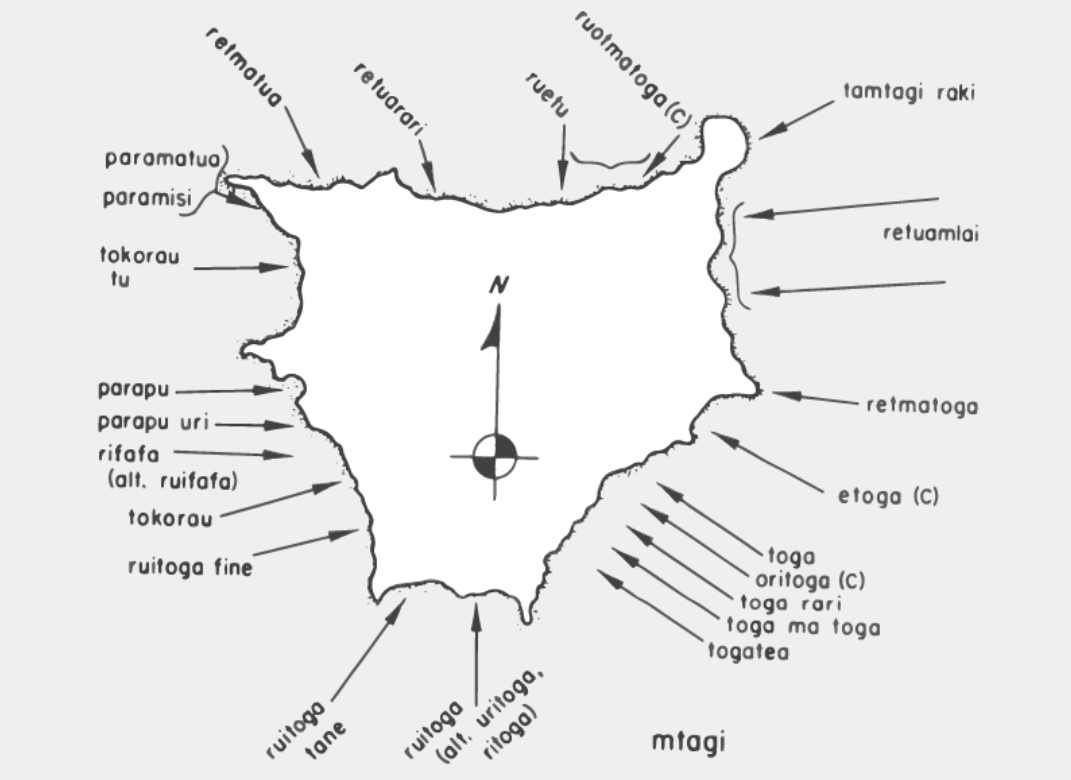
In Vanuatu, we relied on key informant interviews and co-production of knowledge with local experts (including two co-authors of this paper) to collect our data (Harrison, 2023). The Futuna-Aniwa dictionary (Dougherty, 1979) is the only source we found that represents all the winds in a single illustration, as a system, rather than as separate entries dispersed throughout the dictionary. Upon finding this example, we presented it to local collaborators on Futuna to elicit their knowledge on the topic. The decision to visualize the Futunan winds as vectors towards a map of the island was made by our Futunan collaborators, and both the results of that process and our later searches through other lexica suggest that this is an effective way of recording a wind system. Many past investigators appear to have imposed a Western bias for symmetry on the compasses they recorded, thus sparking Dodd’s (1972) praise of Handy (1932) who did not. It is highly unlikely that all of the winds found in past studies were strictly tied to cardinal points such as north or south-southeast but rather came from intermediate points and broader ranges, or sectors. The method used to record the Futunan compass also preserves the relationship between the winds and topographical anchor points on the island which might be lost in a more abstract representation of the wind compass.
Lewis (1994) claims that “the basing of wind compasses on shore landmarks would be impracticable on oceanic islands for any but restricted travel within sight of land, or to give the most approximate bearing.” But we found that Futunans view the winds as intrinsically tied to the local geography of Futuna Island. In recording the version of the wind compass which we present in this paper, we first presented a version of the compass found in Dougherty’s (1979) grammar and dictionary of the Futuna-Aniwa language (Figure 2). Community members elaborated upon certain portions of this compass (Figure 3). While refining the compass, they added island toponyms to the map for context, as without them the compass could not be accurately constructed. Lewis may be correct that this wind compass is of limited effectiveness on the open ocean, as a number of winds share the same direction and are different only in the location on the island where they make landfall (for example, see Tokorau tu Parapu uri, Urifafa, and Tokorau coming from approximately the WSW in Figure 3). However, we note that the wind compass is primarily a tool for use on land, and by people who may never set out to sea, as we show in our examples from Vanuatu.
In subsequent conversations about wind lore in other parts of southern Vanuatu, experts we consulted generally used inward vectors towards either an outline of their island or their smaller local area. Some communities described winds only by their cardinal directions, others anchored their winds to geographical features, some elaborated on the origin points of winds, and the community of Lowkal, Tanna provided a more abstracted square wind graphic. We have also recorded the various ways in which these winds are used as tools in daily life today. These uses include short-distance canoe travel, gardening, weather prediction, and ritual weather magic.
3.1 Futuna Island winds
On Futuna Island, wind is observed to blow towards the island along seventeen distinct trajectories, which are spaced around it at uneven intervals. Each wind aligns to a toponym on the island, which serves as a conceptual anchorpoint for its island-ward path. These winds are celebrated and invoked in stories and songs. Each vaka (outrigger canoe) also bears on its stern a carved shape that mimics the outline of a prominent rock protrusion in its home harbor. Islander, canoe, wind, fish, songs, and topography thus link together in a conceptual, mimetic, and multi-sensory navigational system.
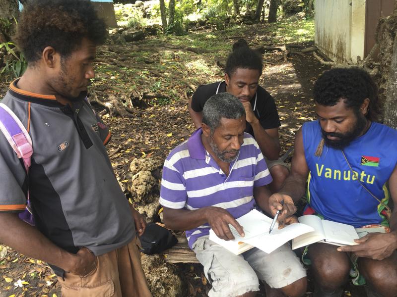
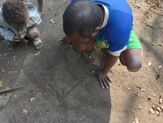
Locals we interviewed on Futuna in 2017 opined that these systems are being forgotten or neglected, but still known to experts. The younger generation spends less time fishing and sailing, thus relying less on traditional navigational knowledge. At a village meeting we convened in Herald Bay, Futuna, a knowledgeable elder, Yaugane Misikofe, described, sketched, and taught the system to an assembled group of young men, including Nigasau Zeiake and Cliffton Napapo, who showed an active interest but had not previously mastered the system.[5]

3.2 Aniwa Island winds
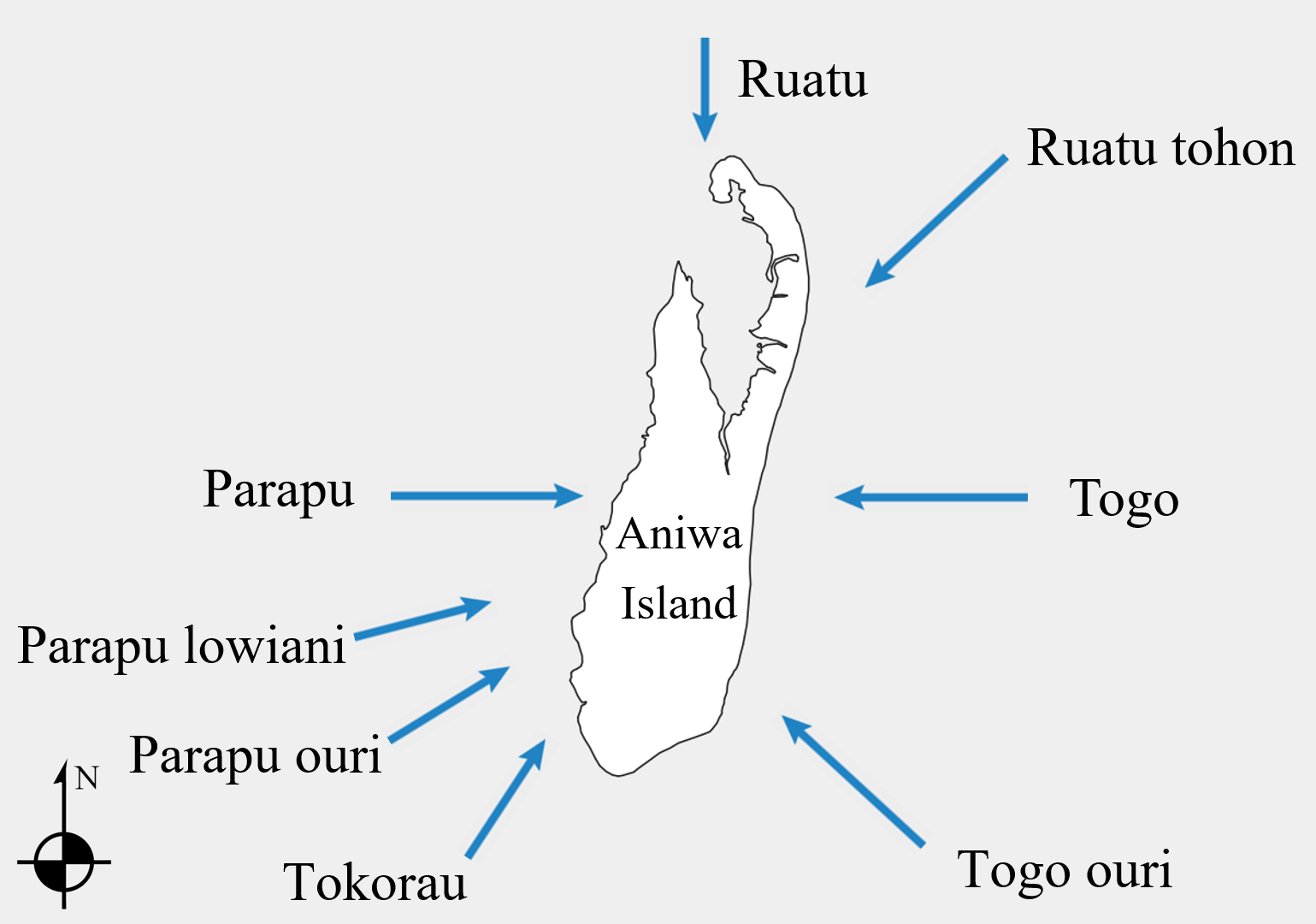
Despite many Polynesian cultural similarities shared with the people of nearby Futuna Island, the wind lore of Aniwa appears to have faded significantly. We interviewed many elders and typically, they confessed they knew no names of winds, or produced only a handful of names, unsure about their direction. Winds that were shared were based on cardinal directions, rather than tying them to geographical features of the island (as on Futuna and elsewhere). The resulting wind map is a combined effort of the people named above. The loss of the wind names is notable because the population of Futuna Island is culturally and linguistically quite similar to Aniwa (they speak two dialects of the Futuna-Aniwa language). The people of Aniwa, like their neighbors on Futuna, still use winds for their short-distance boat rides while fishing and for traveling to nearby islands such as Tanna. Winds are still important for estimating the best course in order to keep the engine from going against the swell and wind and to save fuel.
People on Aniwa also keep track of current wind directions on neighboring Tanna through observation of that island. Smoke from Yasur (Iasur) volcano, and sometimes smoke from Tannese villages, are used to indicate wind on Tanna, which is useful for the frequent travels between Aniwa and Tanna, especially to Whitesands. As chief Matu put it: “When we see the cloud of the volcano point our direction, we know soon we will receive wind in [the] face. The volcano is our compass of wind; we can follow the wind on Tanna with it.” Charley Naumu, an experienced fisherman and sailor of Aniwa added that to go to Whitesands, Tanna, one should follow Parapu (the west wind). Follow Tokorau (the south-southeast wind) instead when you are returning from Lenakel on Tanna’s west coast, then round the southern coast and continue straight to Aniwa.
Winds on Aniwa are observed as weather predictors and indicators of marine animal behavior. They are also associated with clouds, which they are said to bring. Clouds therefore do not have their own proper names, but rather are referred to by the name of the wind. The following details were shared to us as the primary qualities of the major winds. Ruatu is also called Tamtage mnu, “wind of good luck,” because when it blows, fishing further from shore brings plentiful fish. Tokorau is also called Tamtage takau, the “male wind,” because of its strength. Parapu ouri and Togo ouri, “black Parapu” and “black Togo,” are said to bring rain and dark clouds. Another major category of non-directional winds is Sofure. Sofure refers in general to winds “in the middle;” secondary winds that blow from directions between the major named winds. This category is also interpreted as the change of the wind; when one major wind shifts to another or when a wind starts blowing after a time of stillness.
3.3 Tanna Island winds
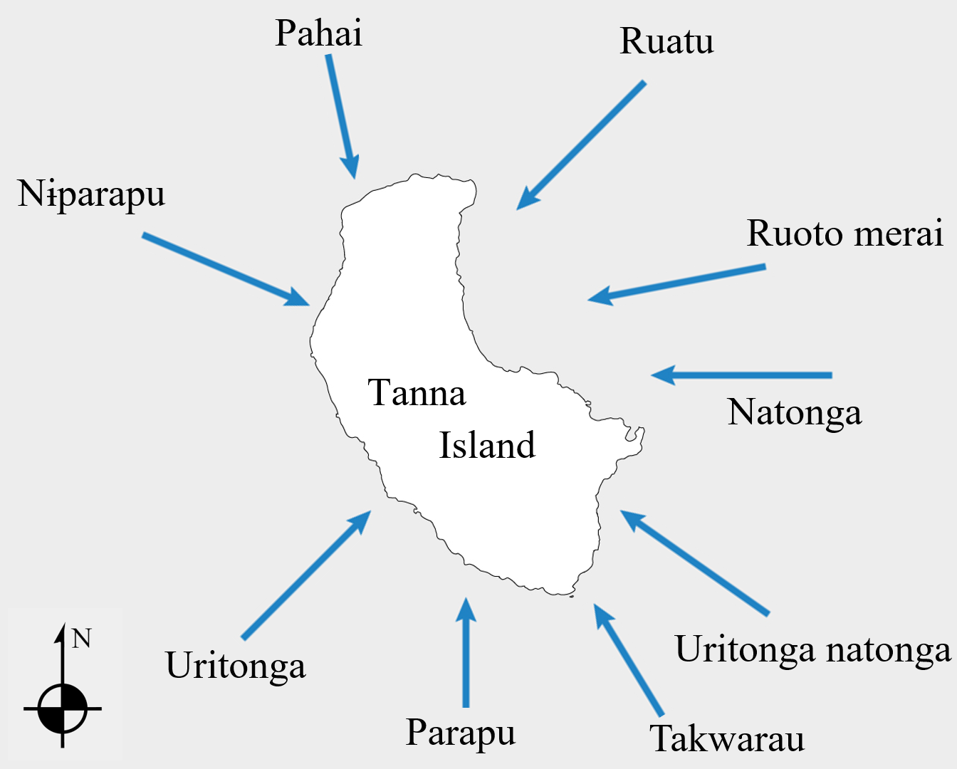
On Tanna Island people sail considerably less than on nearby Futuna and Aniwa, but use wind compasses as a way to interpret the environment. We recorded wind compass systems in five Tanna languages: Naka, Nafe, Nahual, Nanu, and Netwar. These are used primarily on land and also have calendrical and weather prediction functions. Named winds on Tanna are personified as spirits invoked to bring desired weather for planting, harvesting, or other activities. They can also be invoked to harm others, and conflicts arising from accusations of this nature have occurred recently.
Winds may be ritually summoned by special practitioners called tɨpunɨs ~ tupunus ~ tupanas (translated by our consultants as “workers” or “special workers”). These winds, however, are not generally called for the purpose of aiding in navigation, as people on Tanna rarely engage in long-distance sailing. The wind names—some of which reveal Polynesian or Oceanic etymologies—reflect a history of cultural contact. Today, directional winds form an integral part of the local time-reckoning system, with each wind bearing a strong seasonal association and informing cycles of weather, agriculture, fishing, and well-being. Many of these winds are considered seasonal, and according to oral narratives, their seasonality was known to be stable over a long period of time. But recently, people report changes in the timing of these formerly seasonal winds. Each wind has attributes that reveal intricate knowledge of the environment.
Naka
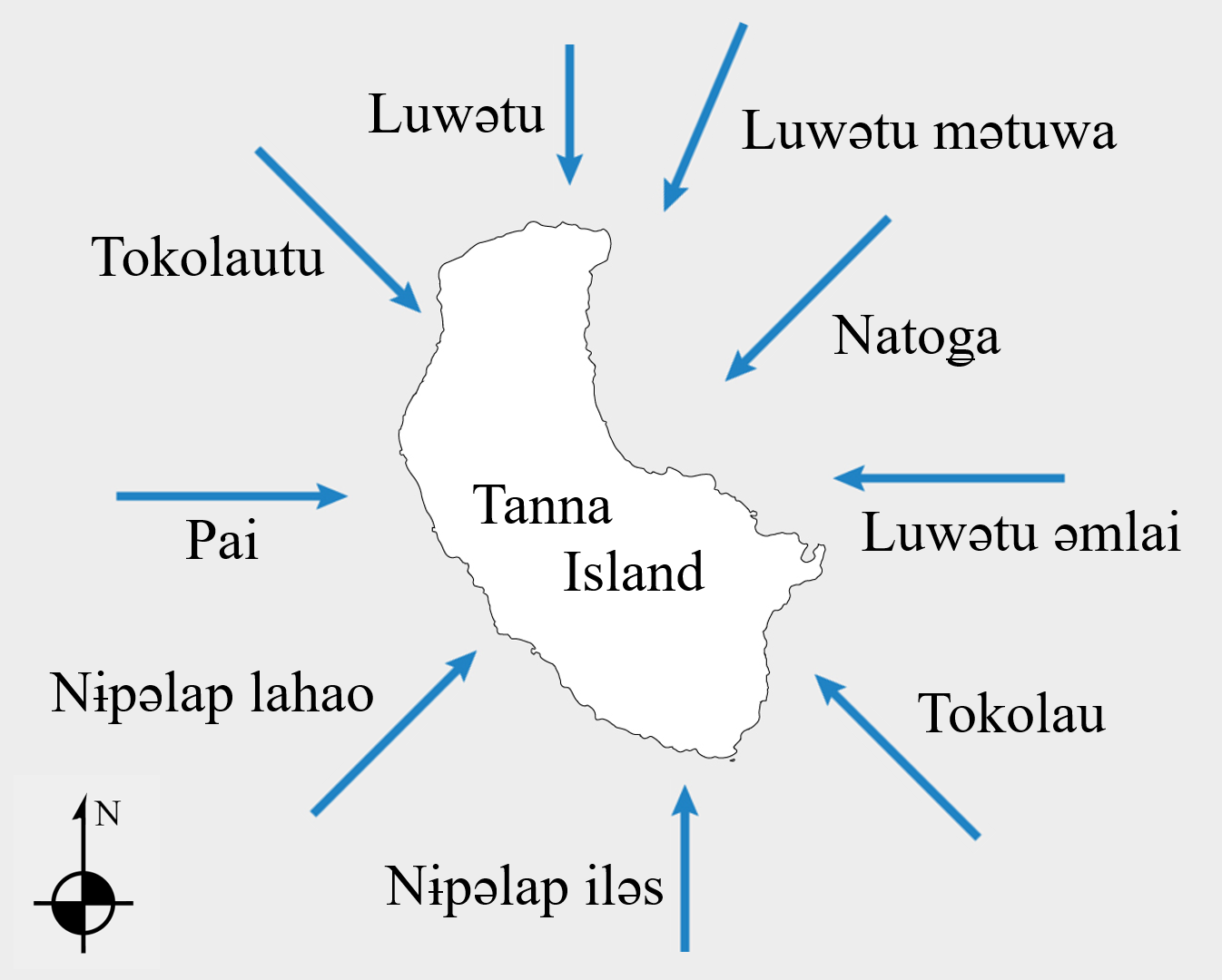
For the Naka-speaking people of north Tanna, winds are personified as spirits (sometimes referred to as “men”). The tɨpunɨs plays an important role in north Tanna culture, managing the winds to keep the people safe and well-fed. The tɨpunɨs acts as a kind of mediator between the weather and Naka gardeners, ensuring that both people and winds stay in balance and on schedule. He may perform various other rituals using plants and sacred stones to influence the weather (Balick et al., 2022). Our colleagues in Nusumetu drew winds based only on cardinal directions, but also provided detailed information about the qualities of individual winds.
Perhaps the most important wind on this part of Tanna is Luwətu, the north wind. Luwətu brings optimal weather for gardening, including fog and rain, while it is also the wind that brings damaging cyclones. Luwətu is most active while nuɨg (wild cane, Miscanthus floridulus (Labill.) Warb. ex K. Schum. & Lauterb.) is flowering and the weather is quite hot, approximately from August to February.
Just as Luwətu can be used to forecast the weather and determine what activities are needed in the gardens, the other winds also inform the islanders of changes in weather and agricultural cycles. Natoǥa, the northeast wind, comes (or is called for) during the time when people will “brush” their gardens (i.e., clear land for a new garden), from June to August. Its dryness helps people burn the leaves and grass they have cleared from the plots. Tokolao, the southeast wind, is known as the “dirty wind.” It carries ash and acid rain up from Yasur volcano in southeast Tanna, and destroys fruits and gardens, especially when the plants are flowering (e.g., naigen (B. edulis), nəw (Inocarpus fagifer (Parkinson) Fosberg), mango, and nakavika (Syzygium malaccense (L.) Merr. & L. M. Perry), and root crops will not be healthy. It may occur at any time of the year.
Luwətu əmlai, the east wind, appears from August to February, when the wind shifts between the north and the east. This is a time when garden crops are growing, and the days are variably rainy or dry. Nɨpəlap lahao, the southwest wind, occurs from May to July, and brings colder air, especially at night. It also brings dry weather, which causes taro leaves to dry out and the tubers to begin to shrink, so this is a good time to harvest taro. Tokolautu, the Northwest Wind represents a balance between the rainy North wind and the dry West wind. This may occur at any time during the year, and is a good wind for fishing because fish are spawning during this wind. Luwətu mətuwa (or Luwətu a sol), the north-northeast wind, is similar to the northwest wind, and is a good time for fishing.
Lastly, Nɨpəlap iləs, the south wind, comes in the dry season between July and December. Sometimes this is very desirable, especially when holding kastom ceremonies.[6] It is also a good time of the year to harvest crops. Pai, the west wind brings “big sun,” and may occur during any time of the year. The west wind brings the toti (Bislama “dirty,” meaning debris of leaves and wood) to the shore, and therefore this is a bad time to swim or bathe. The sea must clean itself so that it becomes safe for people to swim.
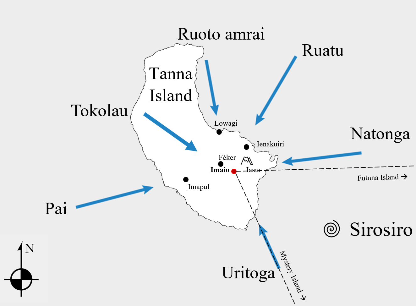
Nafe
Speakers of the Nafe (Kwamera) language of southeast Tanna consider their area to be the “captain” of the sun, wind, and all weather across the island because the prevailing weather patterns come from the southeast. They name winds differently than do their fellow islanders, but share certain beliefs concerning wind function and control by magic (Balick et al., 2022). Within the Nafe language area, there are differences in wind lore based in part on dialect and geography. The winds seen in Figure 6 were drawn by Martial Wahe around a printed outline of Tanna, without any reference to specific toponyms. Figure 7 is centered on the village where the winds were elicited, rather than the island as a whole, and includes toponyms invoked to convey the direction of individual winds.
The Naka in northern Tanna try to block Tokolao, the southeast wind, from dropping ash on their crops, while the Nafe tupanas from the southeast summon that same wind to blow the ash from Yasur up to the northwest, away from their villages. To the Nafe living on the southeast coast, Natonga, which blows from the east, is a good wind. Kingfishers pull Natonga (“rawi n matagi Natoga”) and associated sunny weather when they sit together facing south and make their calls. However, speakers of the Nafe dialect spoken further inland and to the west of Iasur, recognize Natonga as a good wind for gardening but which can also bring damaging ashes and acid rain. Nafe speakers also recognize sirosiro, the whirlwind, as a destructive “wild” wind distinct from cyclones. This phenomenon is recognized across Tanna, named using similar cognates.
In the Nafe area, winds are also distinguished by gender and by origin. Kapiér sei nui, “stone of fresh water,” are winds that come down from the hills and mountains, while the rest of the winds are said to originate in the sea. Before a cyclone, it is said that all of the winds go up north to join Ruatu; the calm before the storm. Lindstrom (2020) relates a Nafe story told to him by an old man about the mythical culture hero Mwatiktiki, who appeared to islanders and “...revealed his wind power stones hidden inside his house, a house with seven windows each of which releases one of the seven winds. ‘When people on Tanna call up a wind,’ Mwatiktiki explains in the legend, ‘I open one window and close up all the others’ ” (Lindstrom, 2020:28).
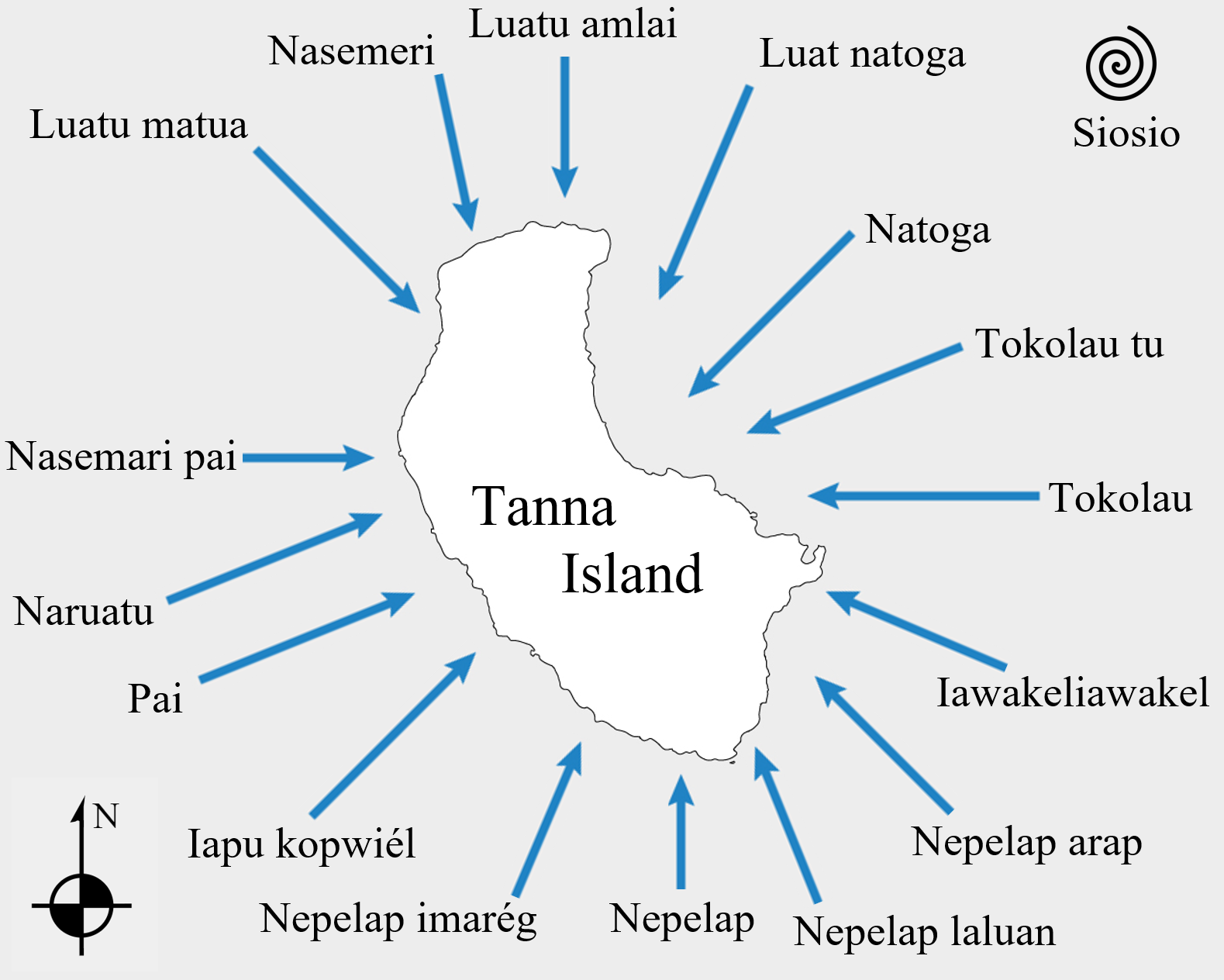
Netwar
Living on the west side of Tanna Island, people in Netwar-speaking villages use wind systems of similar complexity and with wind names that are partially cognate with those of their neighbors, the Nafe and Naka. We write “wind systems,” plural, because as one travels throughout the Netwar language area of Tanna, subtle differences in wind names can be heard in each village. The 16 Netwar winds shared by tupunus Joe Natuman of Lowkwaria are split into two classes, the feminine winds which are humid and warm, bring rain, and “feed the gardens;” and the masculine winds which are cold and dry and bring little rain. The feminine winds range roughly counterclockwise from Naruatu (west-northwest) to Tokolau (east), covering most of the winds from the northern sector. The masculine winds come primarily from the southern sector, from Tokolau (east) clockwise to Naruatu (west-northwest) (see Figure 8). These winds, like the other winds of Tanna, are used as tools in weather forecasting and the organization of the agricultural schedule, rather than for long-distance navigation.
They are, however, still used today for organizing shorter canoe journeys. Nian reniatuan (loosely translatable as the “time of pale color,” its sign being the pale color of gardens during the harvest season of June, July, and August) is the time when it is good to catch the nam lahau min (deep-water fish; lahau meaning deep, min is plural) due to the typical winds of the time which make it easier to go further away from the island in a canoe. Conversely, nian wi (new days, time from August on, when new yam is planted and growing), sometimes called nian reniamera (loosely translatable as the “time of green color,” the sign being the green color of gardens with yam vines growing over them) is the time of many taboos as the iarames (spirit) of the kawar (sacred stone of garden) is at work in the garden with his tupunus. Among the plethora of taboos, there is one concerning fishing. Fishing by canoe further out to sea is taboo, because during this specific period of gardening, prevalent winds blowing west, from shore towards the open sea, make it harder for the canoes to come back from fishing and more likely to get lost.
A number of the winds have more specific connotations than the generally wet and dry qualities of the two sectors. Tokolau, being the east wind at the border between the two sectors, is only a sign of impending rain if it comes as a shift after the constant blowing of the east-southeast wind, Iawakeliawakel. The south wind, Nepelap, is a cold, dry wind which appears in August-September, indicating that it is time for gardens to be cleaned before planting yams (Dioscorea). Nepelap also has a strong association with kwéria, or raptors, particularly the swamp harrier (Circus approximans) and brown goshawk (Accipiter fasciatus). A common saying in Netwar is “kwéria kamerai nemai,” or “the raptor bird is cleaning his garden,” and is generally said when the birds are seen circling overhead on the Nepelap wind.
There is a strong association between the winds and other birds, revealing the complex interlacing of varied natural elements in the Netwar time-reckoning system. The collared kingfisher (Todiramphus chloris)—kéwite in Netwar—is associated with winds bringing clouds and rain, and is said to announce rain with its call. In flight its blue mantle represents blue sky (kapoapen) but its white underparts visible from below represent the white clouds (napua) that cover the blue sky. Similarly, wulawula, the long-tailed triller (Lalage leucopyga), is associated with winds bringing dry weather and sun, said to announce sunny weather with its whistles/trills. Frigatebirds (great and lesser frigatebird, Fregata minor and F. ariel) are also weather indicators. The correct name for these birds in Netwar is lenkai, but often, to underline their relation with winds, they are called “menek taha nematag” (bird of wind), and this name is in fact more commonly used than lenkai. They appear close to islands when strong winds are coming, and are often considered harbingers of the season of cyclones (Ramík, 2015).
People on Tanna sometimes observe that there are two winds, the higher wind (in Netwar nematag iles), and the lower one (nematag lahau) blowing clouds in opposite directions. Pierrot Yeru, an elder of the Netwar community, explained to us that this situation may occur when two tupunus, each in charge of a different wind, try to summon their respective wind at the same time and “fight” together. A situation can arise in which one tupunus calls a wind for good weather for a kastom ceremony and another “jealous” tupunus calls a wind with rain to spoil the ceremony.
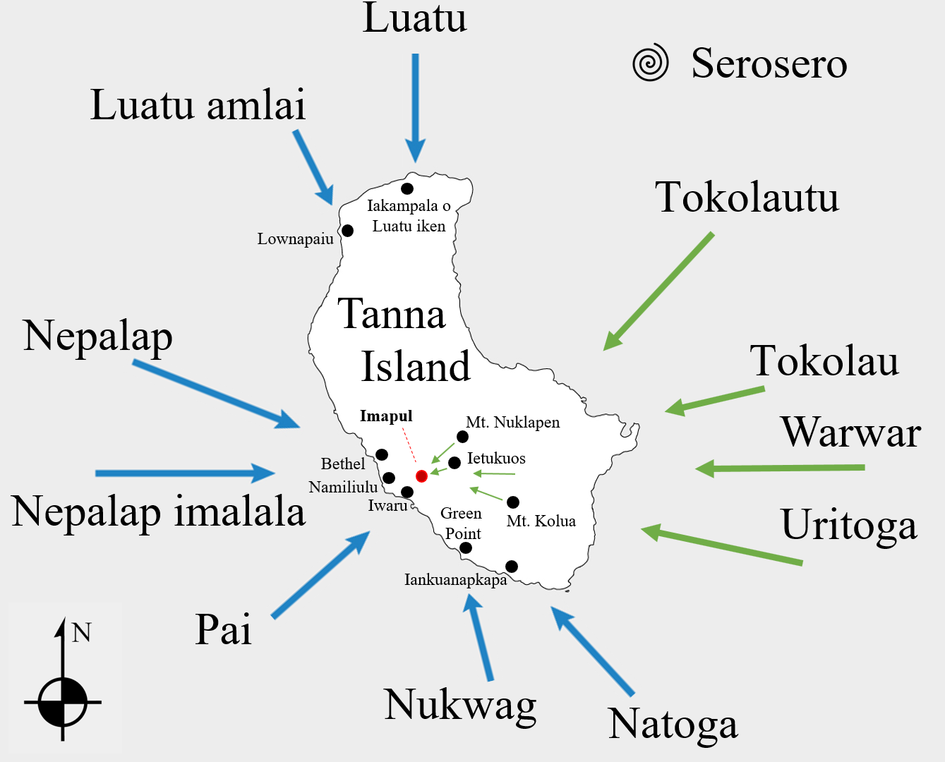
Nahual
In the Nahual (also spelled Nawal) language area of Tanna Island, winds are said to trace or compose a “map” of Tanna. There are specific zones, in which the nakamals (ritual space for men to gather and drink kava) near the shore or in the interior of Tanna are each associated with a different wind. These zones are determined by whether the sacred stone from which the wind originates is located in the sea or whether it is in a freshwater stream in the mountains. The class of winds named kopiél iré (lit. “stone of the sea”) are those whose namesake stone is in the sea and which blow from the sea relative to the Nahual area. The plants used to “cast” or influence those winds are therefore found on the seashore. The class of winds called kopiél nu (lit. “stone of the freshwater”) are those whose stones lie in streams in the hills of central Tanna, meaning their origin is the inland area. The plants used to cast these winds are correspondingly found high in the mountains. In Figures 9 and 10, the green-colored wind vectors originate in freshwater stones, while blue vectors come out of the sea. Larger green arrows show the vector of the wind, while the smaller ones emerge from the locations of their freshwater stones. Both maps are centered on the villages of the experts who drew them, and include toponyms used to anchor winds.
The other factor used to broadly categorize Nahual winds is whether they are feminine or masculine. Iélmana (lit. “male”) winds are dry, with little or no precipitation. They are associated with sunny weather, and the sun is of the male principle. Pilawen (lit. “female”) winds are wet, bringing precipitation associated with rain and often the moon, which is of female principle.
We recorded wind names in two nearby Nahual-speaking villages, which each have minor differences in wind names and what toponyms anchor their direction. Ietalmelen and Imapul are firmly Nahual-language villages. We also gathered some wind lore in Lenapos, which contains a significant number of both Nahual and Netwar speaking inhabitants (Sam Posen, of Lenapos, grew up speaking Nahual). In this area, Tokolau/Tokorau is a freshwater stone wind which is considered the source of all winds. It comes from the mountains, specifically along the kastom road of Kaiapim (near Ietalmelen) or the village Ietukuos (in Imapul) as shown in Figures 9 and 10. It is a good wind, but can become violent if not respected and may carry ash in from Yasur volcano. The time when Luatu and Nepalap winds blow is good for gardens, though Luatu brings hot weather and Nepalap cold.
Birds have close ties with the winds in this area. Mak, a species of ground dove, has a particular route it takes to the sea. When it flies this way every day, it is the time of hot weather and Luwatu, when people should start brushing their gardens. Kawite, the kingfisher, brings Natoga and sunny weather with its call. The whirlwind, Serosero, is associated with the bird called tikiskis, the Grey Fantail (Rhipidura albiscapa). The name of this bird is effectively a synonym with the whirlwind, as explained by Tom Kota:
Serosero…it is properly called Tikiskis, as the bird dances in every direction when perched, but this name isn’t known much today. The whirlwind, it is the source of all winter, it is a wild wind that comes from every direction. The named winds are its children; they are tamed.

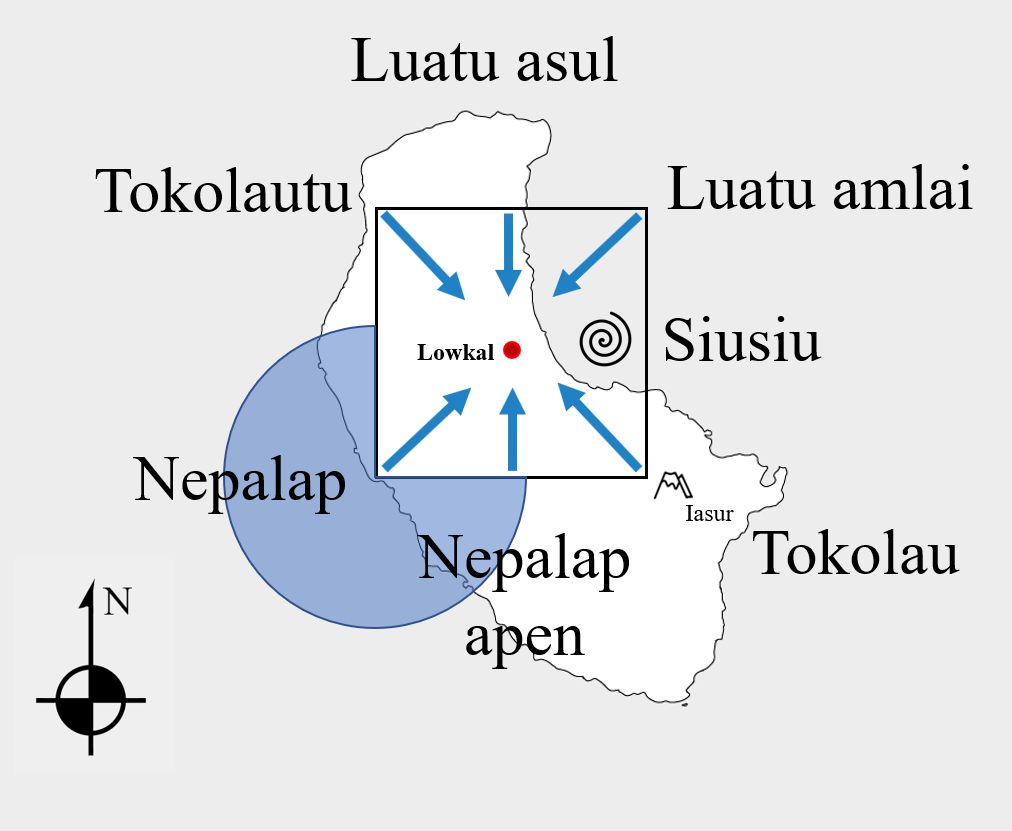
Nanu
On the central eastern side of Tanna, the wind system of the Nanu-speaking village of Lowkal is represented with a square centered on the village. The southeastern corner of the square abuts Mt. Iasur, and the major winds blow in from the corners and the sides. The blue circle in Figure 12 conveys that Nepalap winds blow in from a broad arc to the south and west, not just one vector. Each wind has specific weather associations, and are gendered as in Netwar. Nepalap and Nepalap apen (also called Iapu kopiél) bring cold and sunny weather, while Natoga and Tokolautu bring hot and wet weather. When these latter winds blow in, people say “Takofa nian meta” (“they bring green days”). Tokolau is considered a bad wind in the Nanu area, as it brings acid rain from Mt. Yasur. Nepalap and Tokolautu, on the west side of the square, are female, while the rest of the winds are male.
The collared kingfisher (T. chloris) and the long-tailed triller (L. leucopyga) have the same associations with winds as in Netwar villages. That is, the kingfisher is associated with winds that bring clouds and rain, while the triller is paired with those winds that bring dry weather and sun. Both birds announce their respective weather with their calls.
As in other parts of Tanna, each wind has its respective tupunus. The tupunus of a particular wind works with leaves in an ik aswim, “taboo place,” near a river stream. The stream then carries the nekounat, or medicine (the leaves used in the ritual), down to the sea. The sea is also considered a tupunus, and the entity that actually makes the wind. Each wind also has its ietam le suatu, “man of the road,” a person who is charged with carrying messages from one nakamal to another.
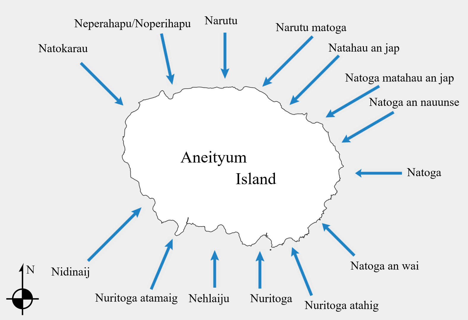
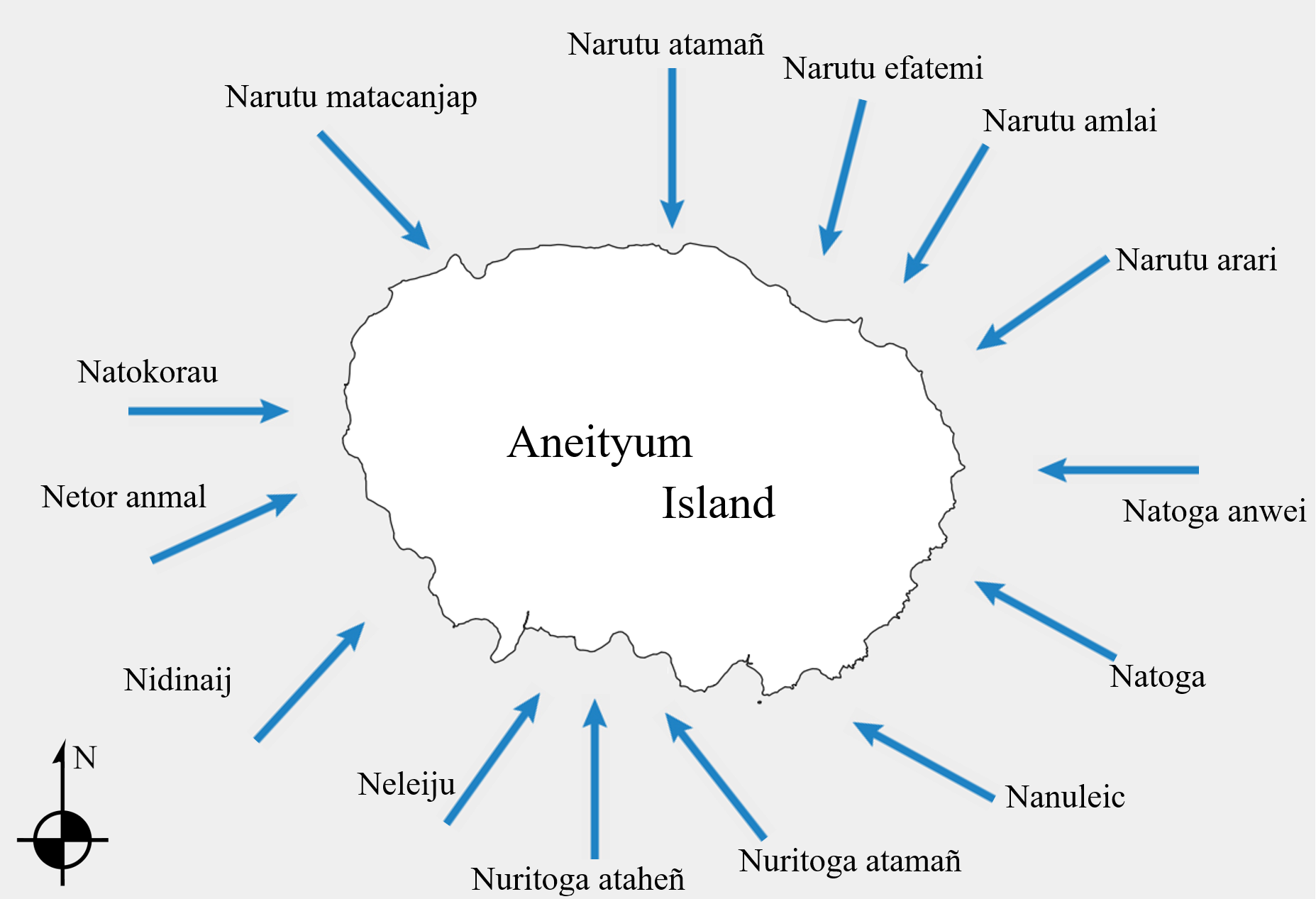
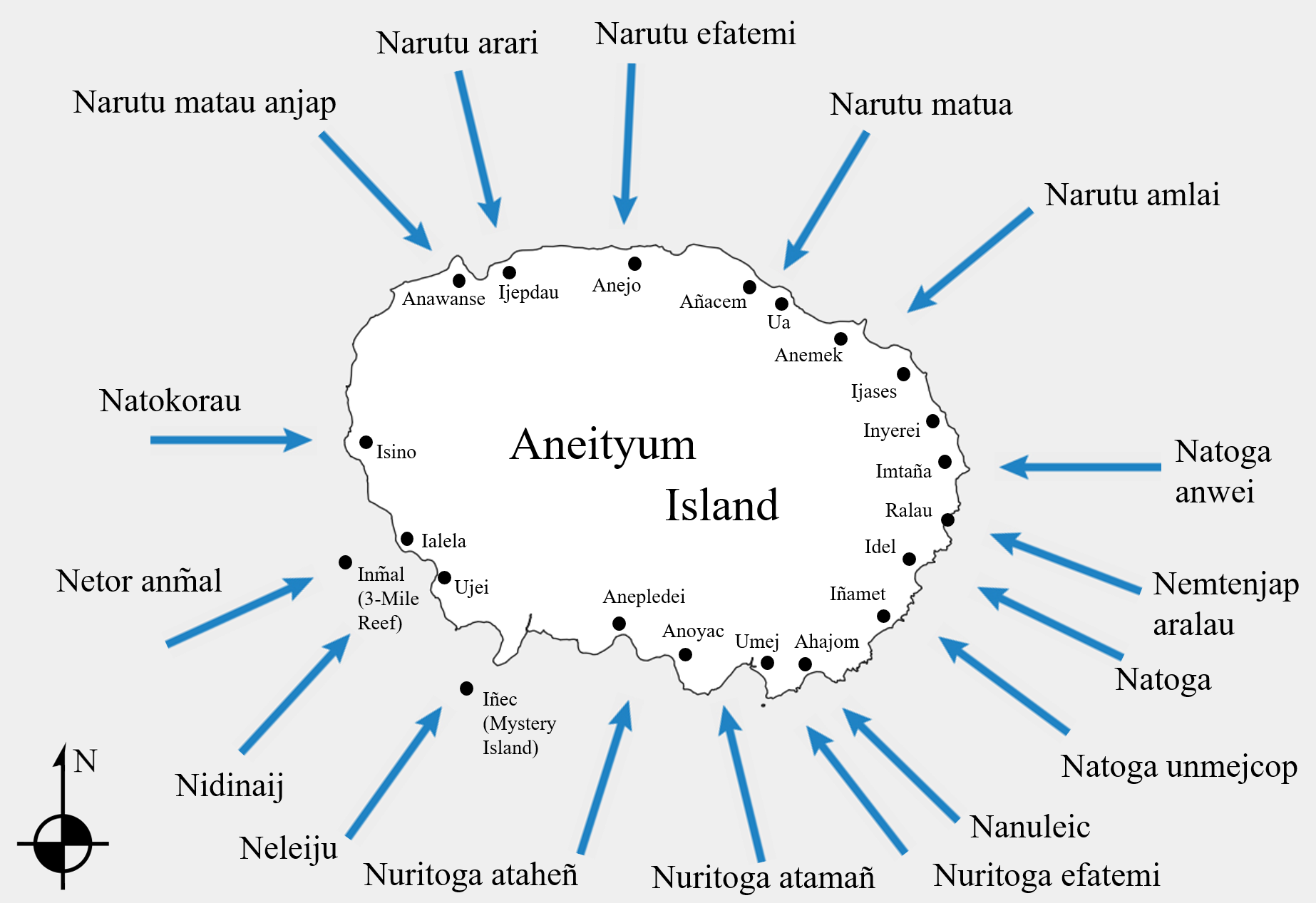
3.4 Aneityum Island winds
Aneityum winds were recorded as individual entries in the Anejom̃ dictionary (Inglis, 1882), and confirmed to us by speakers in 2019 (Figure 13). Two other Aneityum wind maps (Figures 14 and 15) were drawn by Freddy Tamana from Umej village, and Pascal Nañak and Joel Simo of Imtaña, respectively. They drew their maps around a printed outline of Aneityum, and were all very specific about using geographical features (such as reefs and stones) and villages when anchoring the wind directions. The different renderings of Aneityum winds reveal subtle differences in directions and naming, based both on geography and individual knowledge. For example, Nañak reports Narutu matau anjap as coming into their island at Anawanse, while Simo claims that it comes in between Imtaña and Inyerei (on others, they agreed on direction). They explained that some of the winds have strong relations with particular places of the island, and discussed the particulars of Aneityumese wind lore including the qualities of several individual winds. It is important to be aware of the winds and their qualities, especially when traveling around the island by boat.
Winds which make a lot of noise when blowing and cause large waves are of male essence, quiet winds are female. Male winds are called atamañ, female winds are ataheñ. This is the same basic distinction found on Tanna, but it seems that contrary to Tanna, where male winds are considered dry and female winds are wet/rainy-bringing (in line with the general distinction of male principle on Tanna as being related to hot/dry/light and female principle being related to cold/wet/dark), on Aneityum the male-female distinction is more about the male winds being noisy and having a strong impact on vegetation (breaking trees) and sea (large waves), while female winds are more calm. Local consultants explained that this is in line with men being the chiefs, having power and talk (“noisy winds”), while women are calmer and are not heard as much. All the Narutu winds indicate a good time to weave mats as the leaves are pliable and easy to work with. One wind, Nuritoga atamañ has a beautiful song, according to consultant Pio from Umej. He couldn’t remember the full song, but he said other winds are mentioned in other songs depending on the wind’s “work”.
Some winds are binomials headed by the name of a parent wind. These are considered to originate from a very broad arc out to sea, as with Nuritoga: Nuritoga winds are any that come from the southern arc. Within that arc, finer distinctions in direction are made, for example Nuritoga atamañ blows in between Anoyac and Umeij. However, some people simultaneously report parent winds as anchored to specific points or even cardinal directions. Natoga winds come from the east, but Natoga is also the “true eastern wind,” and blows in towards Idel.
Natokorau is a hurricane wind. When it blows, it can often become strong and cause large waves. Neleiju also causes rough seas in the bay of Anelcauhat, as does Nuritoga atamañ, the “male” Nuritoga. All Narutu winds are particularly bad, as they are much more likely to bring hurricanes. Natoga anwei, while blowing during the winter, brings in even colder weather. The weather during Nuritoga ataheñ, the “female” Nuritoga, is mostly sunny. While this wind blows, it is a good time for fishing and making gardens. Natoga winds are sunny and cold, and the true Natoga is a strong wind that “covers up” other winds when it appears.

4. Conclusions and future research directions
We discuss wind compass systems from eight cultures belonging to four islands of southern Vanuatu. Wind systems show varying degrees of complexity, ranging from 6 to 17 named winds. They are distributed circularly at somewhat uneven intervals, and often anchored to locations on the land. Winds are an important environmental indicator on land as well as at sea. Our paper presents a land-based perspective, as we collected all our data on land, and most of it relates to land-based wind lore. Our methodology thus differs from works in which data was collected at sea, while sailing, focusing on the navigational uses of wind (e.g., Feinberg and Genz, 2012).
In our review of literature, we find wind systems attested across Oceania. We cite example systems that range from 5 to 36 named winds, both at sea and on land. We find that wind compass systems are under-represented in the literature, or in many cases not reported as systems but simply as names for individual winds. Many named wind sets can be extracted from lexica, and resemble the systems described here, but were not identified by authors and lexicographers as wind compass systems. Further research is needed to establish if these are still in use, and what purposes they serve(d).
Wind compasses tend to be presented in the literature as a navigation tool, which they sometimes are. But this approach overlooks the fact that people who do not necessarily spend time sailing on the ocean may know and use these systems on land. Named winds have many land-based uses beyond navigation: weather forecasting, time-reckoning (calendrics), gardening, and as a vehicle for other kinds of environmental knowledge (movements of animals, seasonal cycles, etc.).
Our research shows that named winds are part of a larger system of ethno-meteorology, time-reckoning (e.g., environmental calendars), mythology, and weather lore/magic. Wind names, characteristics, and systems are a crucial component of how ni-Vanuatu adapt to and conceptualize their environment. Their significance is evidenced by the fact that in Vanuatu, winds are not only named, but may be described as male or female, as possessing personality traits, specific tasks, and characteristics. Locals believe that the winds may be becalmed, invoked, summoned, and controlled by ritual practitioners using secret lore. Many wind systems—in Vanuatu and elsewhere—await documentation, and can shed much light on human-environment interactions. Wind lore is also a vulnerable and vanishing domain of traditional knowledge.
Acknowledgements
This material is based upon work supported by the U.S. National Science Foundation under grants No. 1555657 (PI Michael J. Balick) and 1555675 (PI K. David Harrison) and by Grant No. 1288 from Velux Stiftung (PI Michael J. Balick), as well as the National Geographic Society, The Christensen Fund, an anonymous donor, the Gildea Foundation, and the Silicon Valley Community Fund. This work was carried out under research license from the Vanuatu Department of Environmental Protection and Conservation, Forestry Department and Vanuatu Cultural Centre (granted 16 October 2013). The Swarthmore College IRB determined that this project does not constitute research with human subjects and does not require IRB approval. The authors thank an anonymous reviewer for valuable feedback.
Endnotes
References
- Balick, M.J., Harrison, K.D., Kelso, N., Neriam, R., Noar, J., Plunkett, G.M., Ramík, D.M., Wahe, J-P., 2022. Weather Magic as Environmental Knowledge in Southern Vanuatu. J. Ethnobiology, 42(4): 383-399. https://doi.org/10.2993/0278-0771-42.4.383
- Balick, M.J., Plunkett, G., Harrison, K.D., Kelso, N., Wahe, M., Ramík, D., Dovo, P., Nasauman, W., Neriam, R., Keith, T., Ranker, T. and Wahe, J-P., 2023. Calendar Plants in Southern Vanuatu. Economic Botany 77: 227–242. https://doi.org/10.1007/s12231-023-09575-w
- Blust, R. and Trussel, S., 2010. The Austronesian Comparative Dictionary: web edition. https://www.trussel2.com/ACD/introduction.htm, accessed March, 2024.
- Clark, R., 1998. A dictionary of the Mele language (Atara Imere), Vanuatu. Dept. of Linguistics, Research School of Pacific Studies, The Australian National University.
- Dodd, E., 1972. The Ring of Fire, volume II: Polynesian Seafaring. New York: Dodd, Mead & Co.
- Dougherty, J.W.D., 1979. West Futuna Grammar and Dictionary. Publisher Not Identified.
- Englert, S., 1993. La Tierra de Hotu Matu'a — Historia y Etnologia de la Isla de Pascua, Gramática y Diccionario del Antiguo Idioma de la Isla (Sixth edition), Santiago, Chile: Editorial Universitaria.
- Feinberg, R., Genz, J., 2012. Limitations of Language for Conveying Navigational Knowledge: Way‐Finding in the Southeastern Solomon Islands. American Anthropologist 114(2): 336-350.
- Finney, B.R., 2007. “Navigation,” in Vaka Moana: Voyages of the Ancestors, edited by Howe, K.R., pp. 154-197. Honolulu: Univ. of Hawai‘i Press.
- Gatty, R., 2009., Fijian-English dictionary: With notes on Fijian culture and natural history. Suva, Fiji: R. Gatty.
- Handy, E.S.C., 1932 (1923). The native culture in the Marquesas. The Museum: Honolulu, Hawaii.
- Hardacre, M., n.d., Dictionary of Raga (North Pentecost) Language.
- Harrison, K.D., 2023. Environmental Linguistics. Annu Rev Linguist 9:113-134. https://doi.org/10.1146/annurev-linguistics-031220-013152
- Hovdhaugen, E., 2006. A short dictionary of the Vaeakau-Taumako language. Kon-Tiki Museum, Institute for Pacific Archaeology and Cultural History.
- Howe, C. 2019., Ecologics: Wind and Power in the Anthropocene. Durham: Duke Univ. Press.
- Inglis, J., 1882. A dictionary of the Aneityumese language. Williams & Norgate.
- Inwards, R. (compiler), 2014 [1898]. Weather Lore: A Collection of Proverbs Sayings and Rules Concerning the Weather. Cambridge Univ. Press.
- Jenness, D., Ballantyne, A., 1926. Language, mythology and songs of Bwaidoga, Goodenough Island, S. E. Papua. J Polynesian Soc 35(140): 290-314.
- n.a., 1993. Rennell-Bellona lexicon. Kaipuleohone University of Hawai'i Digital Language Archive http://www.language-archives.org/item/oai:scholarspace.manoa.hawaii.edu:10125/40877
- Keller, J.D., Kuautonga, T., 2007. Nokonofo Kitea (We Keep on Living This Way): Myths and Music of Futuna, Vanuatu. Honolulu: Univ. of Hawai‘i Press.
- Kelso, N., Plunkett, G., Dovo, P., Ramík, D., Paul Vusqal, C., Harrison, K.D., and Balick, M.J., 2023. The Palolo Worm as a Cornerstone of Pacific Ecological Time-Reckoning. Ethnobiology Letters, 14(1): 24-35. https://doi.org/10.14237/ebl.14.1.2023.1815
- Lefale, P.F., 2010. Ua ‘afa le Aso Stormy weather today: traditional ecological knowledge of weather and climate. The Samoa experience. Climatic Change 100(2): 317-335.
- Lewis, D., 1994 [1978]. We, the navigators: The ancient art of landfinding in the Pacific, 2nd ed. Honolulu: Univ. of Hawai‘i Press.
- Lieber, M.D., Dikepa, K.H., 2019. Kapingamarangi lexicon. University of Hawai‘i Press. https://scholarspace.manoa.hawaii.edu/handle/10125/62886
- Lindstrom, L., 1986. Kwamera Dictionary. Pacific Linguistics Series C, no. 95. Australian National University.
- Lindstrom, L., 2020. Tanna Times: Islanders in the World. Honolulu: Univ. of Hawai’i Press.
- Low, S., 2007. Nainoa Thompson's Path to Knowledge: How Hokulea's Navigator Finds his Way, in: Howe, K.R., (Ed.), Vaka Moana: Voyages of the Ancestors. Honolulu: Univ. of Hawai‘i Press.
- Monberg, T., 1991. Bellona Island Beliefs and Rituals. Honolulu: Univ. of Hawai’i Press.
- Nakuina, M.K., 1990. The Wind Gourd of Laʻamaomao: The Hawaiian Story of Pākaʻa and Kū-A-Pākaʻa Personal Attendants of Keawenuiaʻumi Ruling Chief of Hawaii and Descendants of Laʻamaomao. 2nd ed. Honolulu: Kalamakū Press.
- Næss, Å., 2017., A short dictionary of Äiwoo. Canberra: Australian National University.
- Osmond, M., 2007. Navigation and the heavens, in: Ross, M., Pawley, A., Osmond, M., The Lexicon of Proto Oceanic. Canberra: ANU Press.
- Parsonson, G.S., 1963. The settlement of Oceania: An examination of the accidental voyage theory, in: Golson, J., (Ed.), Polynesian Navigation: Symposium on Andrew Sharp’s Theory of Accidental Voyages. Wellington: Polynesian Soc. pp. 11-63.
- Pratt, R.G., 1984. A Grammar and Dictionary of the Samoan Language: With English and Samoan Vocabulary, 3rd ed. Papakura: R. McMillan.
- Pyrek, C.C., 2011. The Vaeakau-Taumako wind compass: A cognitive construct for navigation in the Pacific. Masters thesis, Kent State University.
- Pyrek, C.C., Feinberg, R., 2016. The Vaeakau-Taumako Wind Compass as Part of a “Navigational Toolkit”. Structure and Dynamics 9(1): 41-69. https://doi.org/10.5070/SD991031887
- Ramík, D.M., 2015-2023. Netwar Dictionary. https://dominicweb.eu/en/dictionaries/netwar-lenakel/
- Smith, S.P., 1892. Futuna; or, Horne Island and its people. J Polynesian Soc 1(1): 33-52.
- Stair, J.B., 1896. Jottings on the mythology and spirit-lore of old Samoa. J Polynesian Soc 5, no. 1(17): 33-57.
- Vern, C., Soulik, T., 1973. Nukuoro Lexicon. Honolulu: Univ. of Hawai‘i Press.