Anfeh costal landscape: preservation, management and landscape planning strategies
American University of Beirut, Lebanon mt63@aub.edu.lb
University of Balamand nadinepanayot@yahoo.com
Abstract
Coasts are among the most complex, vulnerable and sensitive of all natural ecosystems, and their management presents various problems and difficulties especially in our era of climate change in which coastal cities and populations face a range of serious threats (including rising sea levels). The singularity of these areas necessitates an equally singular handling of the issues of their urban development and management (Beriatos, Papageorgiou, 2010).
In Lebanon the severe anthropogenic pressure on the coast is rapidly changing its landscape character shaping an elongated urban development that spread for 220 km from north to south. The paper focuses on the northern Lebanese coast where we believe opportunities for sustainable development resides in the natural, cultural and archeological assets. It reports the findings of the study that was performed in this village in 2016-2017 as part of a third-year cultural landscape design studio at the department of Landscape Design and Ecosystem Management, American University of Beirut.
Keywords
Coastal landscape, cultural landscape, landscape planning and design strategies
Introduction
The relationship between sea/water, coast/nature and urban development is becoming critical especially in the Mediterranean region where there is a high percentage of human concentration of activities and exploitations. This region accounts for nearly one-third of the world total international tourist arrivals and 26% of world tourism receipts, with coastal tourism activities constituting the main type of tourism of most Mediterranean destinations (Owaygen, 2004). Coasts are among the most complex, vulnerable and sensitive of all natural ecosystems, and their management presents various problems and difficulties especially in our era of climate change in which coastal cities and populations face a range of serious threats (including rising sea levels). The singularity of these areas necessitates an equally singular handling of the issues of their urban development and management (Beriatos, Papageorgiou, 2010).
In Lebanon the severe anthropogenic pressure on the coast is rapidly changing its landscape character shaping an elongated urban development that spread for 220 km from north to south. Interest groups and rent seekers competed in the past 30 years and are still competing for the use of coastal resources in the areas of both spatial exploitation and resource extraction. According to the United Nations Environment Programme (UNEP), the total built-up area along the coastal zone in 1995-1996 was estimated at 40,000 ha which represents approximately 26% of the surface area of the coastal zone. According to various sources, the current coastal urbanization ranges between 40% and 55%. The Mediterranean Environmental Technical Assistance Program, METAP / World Bank report issued in 2009 claims that, if kept unchecked, this trend could lead to a total urbanization of the narrow Lebanese coastal corridor by 2025 and carry more than 85% of the Lebanese population (CANA-CNRS, 2009).
A consistent part of this percentage is allocated to touristic resorts that with their marina are reshaping the seashore border, privatizing the access to the sea, offering little interaction between locals and visitors, increasing the environmental destruction and the cultural impoverishment. The paper focuses on the northern Lebanese coast where we believe opportunities for sustainable development resides in the natural, cultural and archeological assets. The 2030 Agenda for Sustainable Development and Sustainable Development Goals (United Nations 2015) strengthen the idea that cultural heritage and landscape conservation / regeneration effectively contribute to making cities and human settlements safe, inclusive, resilient and sustainable (Goal 11). Cultural and Natural Capital are key assets of sustainable development able to end poverty in all its forms (Goal 1) and protect, restore and promote sustainable use of terrestrial ecosystems (Goal 15).
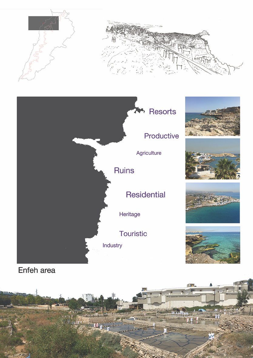
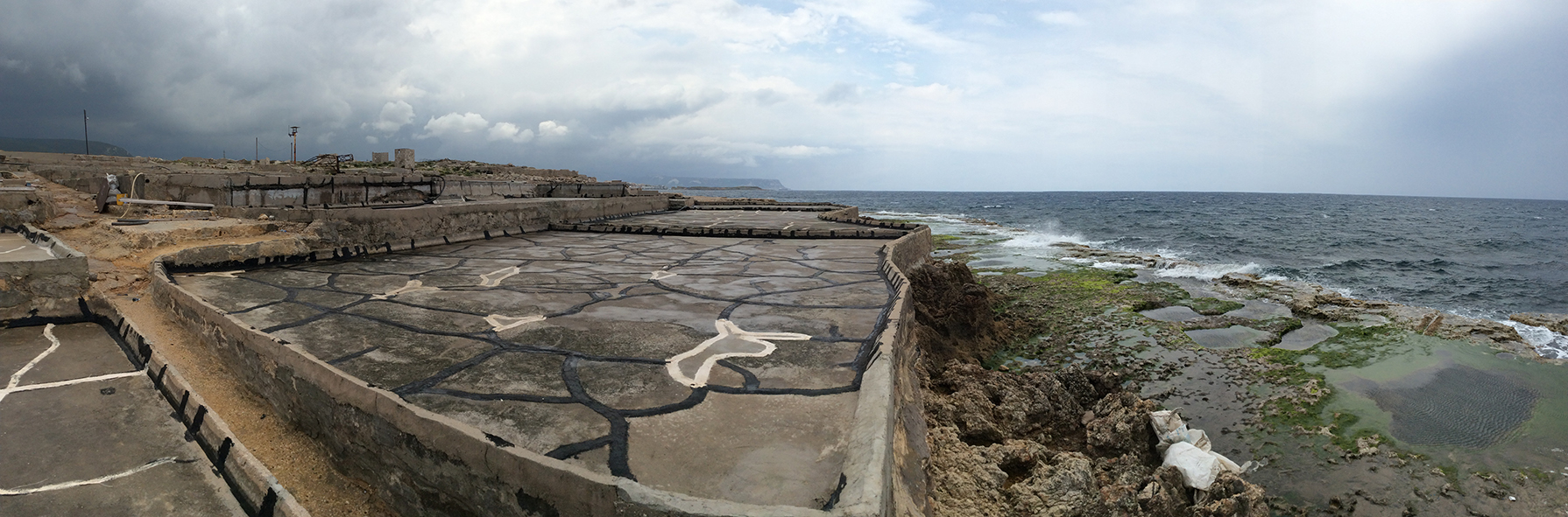
Anfeh, a small coastal village in the north governorate (Figure 1) was chosen as a case study. The reasons lay on the fact that this small municipality, that today appears in a state of decay and abandonment, due to its unique characteristics was throughout a significant time of history a center of attraction to historic cultures, leaving massive traces that are still readable in the region (Figure 2). Known for its extensive salt production that created an incredible hydrological landscapes along the seashore (Figure 3), Anfeh appears now a days as an inventory of ‘third spaces’, places of 'scrap, waste, margin' (Lai, 2016) that despite their past organization and economic activities are currently attractive areas for birds and hunters.
The question that arises is how to balance the different interests that are concentrated along the border between offshore and inshore with the ecological and historic/archeological components of the Lebanese coastal area and of Anfeh in particular.
Various drivers and demands meet (Selman, 2009) in this space along the Eastern Mediterranean rim putting in danger natural features and historical remains. In 2016 and 2017 an investigation on Anfeh municipality was conducted by landscape students at the American University of Beirut (AUB) with the aim to respond to the above question. The paper reports the findings of the study that was performed back then in this village as part of a third-year cultural landscape design studio at the department of Landscape Design and Ecosystem Management, AUB. The research was anchored on the cultural landscapes theory as defined by Carl Sauer as ‘fashioned from a natural landscape by a culture group’ (Sauer, 1925). It helped us in articulating an approach to the planning and management of Anfeh using landscape as process to protect the cultural and ecological infrastructures for an expanding human settlement. Furthermore the research tied on the UNESCO Recommendations on Historic Urban Landscape (HUL) (2011) that recognize the fundamental role of cultural heritage and landscape for sustainable local development and highlight the opportunity of adapting heritage to the present needs of society. The work benefitted from the extensive experience of Professor Panayot from the University of Balamand who has been, since 2011, directing a terrestrial and maritime archaeological and ethnographical survey and excavation project in Anfeh. The purpose of which is to promote the use and the conservation of tangible and intangible Cultural Heritage as a necessary tool for ecotourism and sustainable development (Panayot et al. 2016). She has introduced us to the archeological and socio-cultural features of Anfeh and actively collaborated with us during the 2 years of the research. This article considers the maritime and terrestrial cultural landscape of Anfeh/Hraishy (Figure 4) albeit an understudied coastal site in North Lebanon. It seeks an appreciation of Anfeh’s heritage, past, present and potential future (Panayot & Semaan 2018). It details the tangible cultural assets of the area which were put forth since 2011, when the Department of Archaeology and Museology at the University of Balamand (DAM) undertook an interdisciplinary project approved by the Lebanese Directorate General of Antiquities (DGA), aiming at reconstructing the history of Anfeh using recent archaeological data, obtained from surveys and excavations, oral histories, and written sources.
Coastal landscape
Coastal areas are especially important to human well-being with half the world's population living within 60 km of the sea and three-quarters of all large cities located in the coastal zone (Brown, Hausner, 2017). The extreme nature of these physical surroundings encourages specific kinds of awarenesses, merging their oppositions – conscious and unconscious, material and immaterial, bodily and mental (Ryan, 2012). The term coastal landscape implies a relationship between land and sea (Vogiatzakis, I.N., Griffiths, G.H., Cassar, L.F. & Morse S., 2005). But as reported by Doring and Ratter, this relationship is based not only on the physical bonds and practical use of the coast to obtain economical benefit (Dorin, Ratter, 2017). It represents a tangible and intangible livelihood (Ingold, 2000, pp. 9–12) through which people, communities and societies reproduce and experience themselves (Matless, 2001, pp. 73–95). A number of publications (Boissevain & Selwyn, 2004; Gesing, 2016; Ryan, 2012; Visser, 2004) apply landscape-related theories to coastal areas, conceptualizing coasts as dynamic passage points where societal, cultural, economic and natural processes meet, interact, shape and materialize as coastscapes. Where coastscapes are interpreted as the basic context of everyday life that encompasses both sea and land (Tartaron, 2013). In the research conducted with the students we used this lens to read, interpret and intervene in Anfeh proposing more context-sensitive design approach to manage and plan future coastal changes. The Anfeh coastal landscape was interpreted as the layering composition of historical and everyday practices where socially flexible and culturally stabilizing entities interlace coastal dwellers and their dwelt-in coastscape exhibiting manifold ways of meaningful immersion and relationship. Hence, the present approach offers the opportunity for “a better understanding of the intangible (…) (meaning dimensions of coastscapes) held by the local population” (Ratter & Gee, 2012, p. 136). Such an approach uncovers the multi-layered bonds coast-inhabitants and allow for a more integrative strategy.
Materials and method
Study area
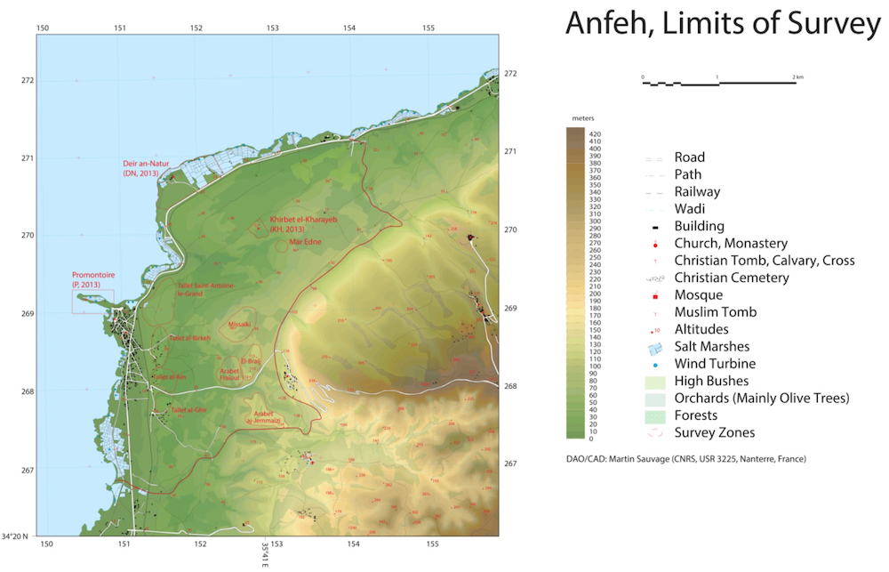
Due to its unique geographical position, Anfeh was a center of attraction throughout the history playing an economic role during the Late bronze Age, the Phoenician, Roman, Byzantine, and the Medieval periods up until the Ottoman period (Panayot, 2015). The occupation of the city during the Canaanite period is more than certain. Anfeh is, indeed, traditionally identified with Ampi (Freyha 1972:6) and is mentioned six times in the Amarna letters. In his correspondence with the pharaoh, Rib-Addi, king of Byblos, who was a faithful subject of the Amarna court, mentions the port and the fleet of Ampi, telling the Egyptian monarch that the enemy ships of Arwad had reached the city (EA 71, 72, 76, 95, 102; Collon and Cazelles 1987:296; Salamé-Sarkis 1999:78).
The ethnographic campaign which was conducted in the village in 2013 on the socioeconomic settings of Anfeh, (Figure 5) confirmed that salt was indeed the white gold of the village between 1943 and 1990 and hence became the major source of economic income for the local community reaching 50,000 tons of salt production per season. Indeed, as several others coastal zones along the Mediterranean basin with an ideal climatic conditions with long, warm, and dry summers and favorable etesian winds, Anfeh was an area of salt exploitation through solar evaporation that has been extensively practiced for many hundreds of years (Petanidou, T. 2004).
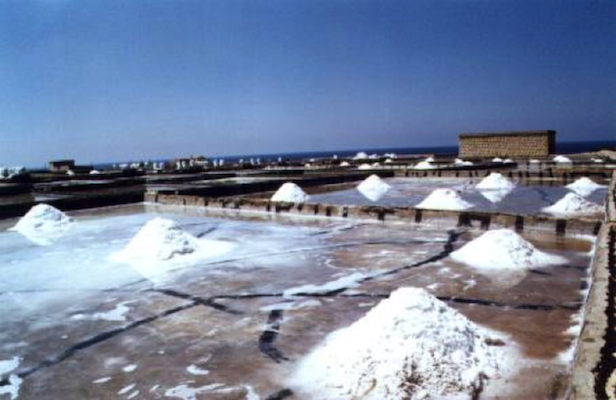
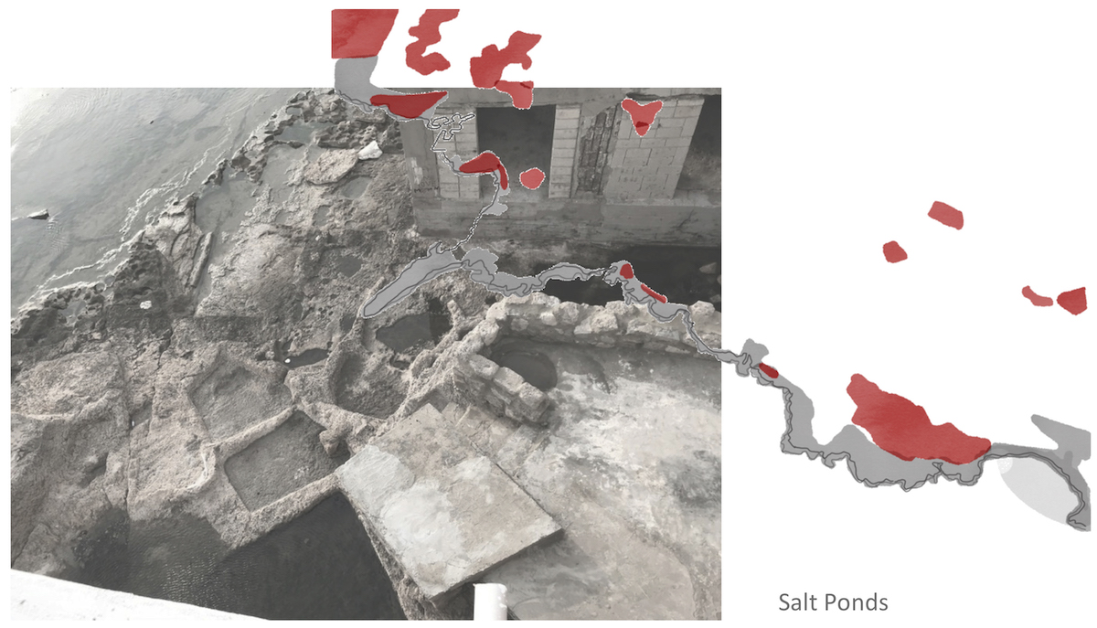
However, in the early 1990’s, the Egyptian salt was imported to Lebanon exempt from taxes that started a long agonizing process of the salt production in Anfeh/Hraishy. Only 11 salt producers are still active today (Kalindjian, 2018). Nevertheless, all of the inhabitants reported hoping to jumpstart their salt production, if a market was secured. The remaining abandoned salt marches present a desolate scene, but luckily, they have preserved the archaeological layers underneath and they have turned into a safe haven for migrating birds. The abandoned productive landscape of a former salt works determined the proliferation of wastelands that were once highly organized to support the salt economy. Today, they form a unique and remarkable landscape that needs to be classified along with the ancestral know-how of salt production. In between the ruins and the proliferation of the wilderness, canals, concrete ponds, systems of pedestrian and car routes are still in place pointing out the system that connected sea, shore, salt works and ponds. Those areas are today one of the symbolic features of Anfeh cultural landscapes.
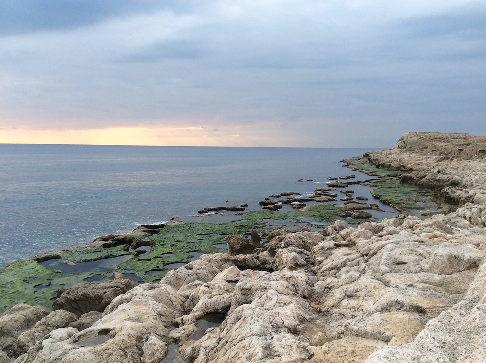
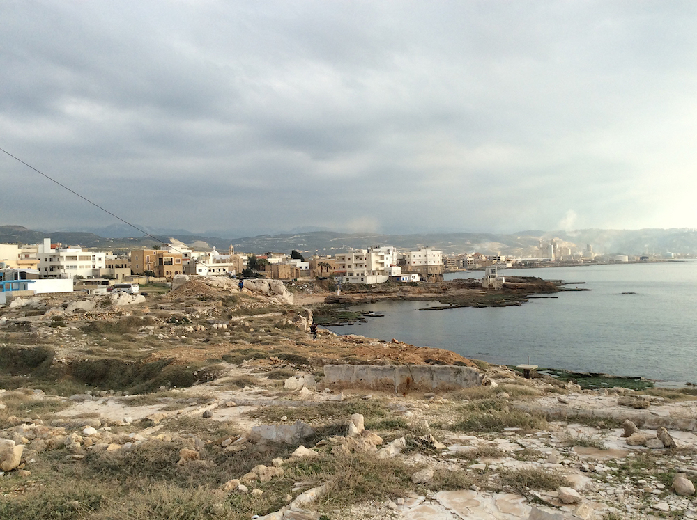
Furthermore, with its limestone rocks and vermetid reefs forming the peninsula, Anfeh’s geomorphology is unique and stands out from other coastal areas in Lebanon (Figure 6). The coastline of the area presents a more or less wide abrasion platform (2-10 m width) with rocky pools and, in some places there are small littoral caves. The abrasion platform is more or less wide, although there are variations among the zones (between 1 to 20 m width). The shallower rocky seabed is formed by submarine vertical surfaces (1-6 m high) with big blocks at the base. The village littoral fringe, that can be identified by the abrasion platform, the shallow littoral ponds and surf zone, owns a particular ecological relevance due to the 27 marine habitats that have been observed, standing out: pools and lagoons associated with vermetids, Biocenosis (B) of midlittoral caves, Association (A) with Neogoniolithon brassica-florida with Dendropoma, A. Sargassum vulgare and Cystoseira compressa, A. Schottera nicaeensis, Facies (F) coralligenous in infralitoral enclaves, B. semi-dark caves, and Cymodocea nodosa meadows (RAC/SPA — UNEP/MAP, 2014). The vermetids are attached marine gastropods that have lost the typical “snail form”. They live attached to hard surfaces in irregularly elongated tubular shells. Two species of these unusual snails live attached together in colonies and can build reefs. The vermetid reefs are endangered of extinction and are exclusively found in the warmest parts of the Mediterranean Sea. They form the beautiful platforms that run parallel to the Lebanese shoreline. Their porous structure provides habitats and food to a rich and diverse community of animals and seaweeds (El Shaer, Samaha, Jaradi, 2012). However, those vermetid platforms are increasingly being threatened mainly due to sewage and industrial runoffs, and to littoral disturbance determined by urbanization, ports activities and sediment filling.
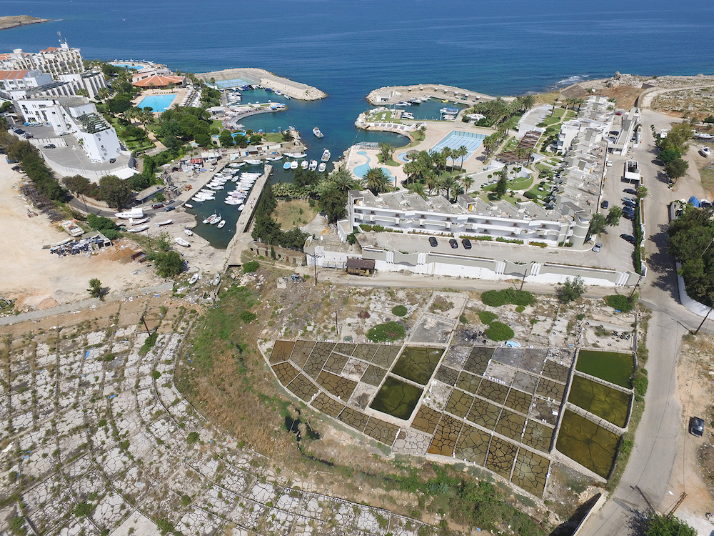
Until the beginning of the last century, the coast and the inland areas were connected with interaction between the fishing and salt production activities, and agricultural practices. Today the inland’s economy is almost dead and the coastal landscape is highly consumed by the mass tourism sector and its unsustainable development. Resorts and marinas are filling the void left by productive activities determining an artificialisation of the coastal landscape. This phenomenon is eroding the valuable natural and cultural heritage of Anfeh causing ecological disturbance, land-use change, and loss of cultural identity (Figure 7). Indeed Anfeh has historical and cultural values that are totally underestimated.
The archaeological surveys and excavations on land and underwater undertaken by DAM of the University of Balamand since 2011, have revealed the existence of several archaeological remains that need further exploration and which confirm that Anfeh and its hinterland is a rich and promising site. The results have isolated four major occupation levels underneath the salt pans dating back to: the Chalcolithic Period, The Bronze Age Period, a Late Byzantine occupation level associated with a strong religious presence represented by a cluster of religious spaces in Anfeh. As well as a documented medieval occupation during the Crusades Period confirmed by DAM data collection on site. Uncovering and confirming these four occupational levels does not mean that all the other periods are nonexistent, or that there are chronological gaps, but this surely shifts the chronological tableau and the assumptions made throughout the years by both scholars and the civil society.
Methodology
The methodology for this research is through design: it entails experiments of landscape characterization and landscape planning and design to produce schemes for future intervention in the contest of cultural landscapes. It was grounded in science-driven methodology to allow us to relate, link and overlap interventions at various scale in an interdisciplinary process that combine biodiversity, archeology, geomorphology, landscape urban design, community’s involvement.
Landscape architecture analysis and design methods such as cartographic interpretation, fieldwork, informal interviews, corroborated by literature review on cultural landscape, historical documentation, and law and regulations review and understanding were used during the length of the research.
The study of the maps allows us to investigate and understand the landscape components of Anfeh. Acknowledging the complexity and stratification of the overlapped historical layers, mapping was the tool to read, interpret and represent the site while describing the processes and activities taking place. A study on the legal framework was conducted to get an awareness of the rules and to verify the way they where implemented throughout the time and especially from the end of the civil war till today. Threats and opportunities were evaluated before to set up a strategy of intervention.
The cultural landscape design studio was organized in two phases. The first one was based on a literature review of the cultural landscape theories, and on the inventory of the cultural features of Anfeh. A cultural mapping was produced to explore, discover, document, analyze, interpret, and represent all the relation and bounds between local community, places and their historical stratification (Bandarin, Ron van, 2016). Furthermore the mapping exercise was our powerful tool to grasp the socio-cultural realities of communities, landscapes and ecosystems involved. The historical evolution of the village was drawn out using written documents and findings, based on the study professor Panayot is conducting on site. The fieldwork focused on the assessment of the character and quality of the spaces through the observation of all the forms of appropriation and construction of lived place in the study areas. In the second phase we set up strategies of intervention grounded on the Historical Urban Landscape approach. From ground-work, collected evidences were studied using supporting materials from historic research (TCLF, 2016). The design process was underpinned by an investigation’s process that allowed students to experience the space and draw down the landscape character of Anfeh as expression of the relationships occurring between the multiple features founded on site. Thus the landscape design propositions were developed to preserve, manage and plan the cultural and natural heritage of the place.
Results
The students’ works are a collection of local place-specific solutions (Figure 8), which test and approach the cultural, social and ecological processes while addressing the complexities of everyday life. With their projects students explored landscape strategies to couple with the challenges of the site proposing design interventions that suggest beneficial relationships between settlement form, culture, society and ecological environment (Briant, Allen, Kebbell, 2017).
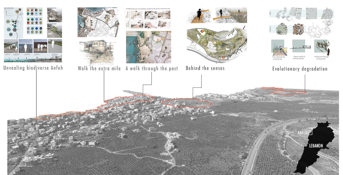
Two main aspects were taken in consideration during the length of the research: the landscape character of the place and its cultural identity as ‘fashioned from a natural landscape by a culture group’ (Sauer, 1925). Both of them helped the research in articulating students’ approach to the planning and management of the site addressing Anfeh main challenges. Indeed they stood for: re- invigorating and re-adapting traditional cultural practices to do with salt production; for emphasizing the extensive and in several zones neglected archeological features (Panayot, 2015) reconnecting them to the city, and for preserving the marine biodiversity to do with the vermetid platforms, rocks and coralligenous concretions at shallow depth, crevices and overhangs common (El Shaer, Samaha, Jaradi, 2012). Interventions were always at a local scale with the intention that local influences would then extended to encompass beneficial effects for the whole region.
Cultural Practices
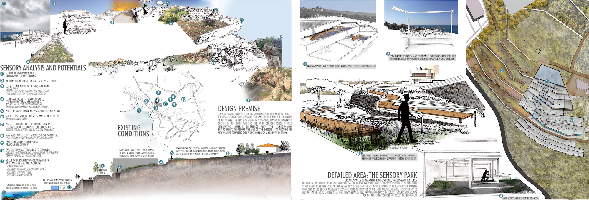
The socio-cultural transformations and the decline of past production activities that occurred in Lebanon during and after the civil war had a deep impact on the spatial equilibrium and organization of the country. While in the European countries bordering on the Mediterranean, spaces such as transhumance routes, ponds and salt pans have been reconstructed and recovered to become part of historical, cultural and environmental heritage (Lai, 2013), in Lebanon the increased interest in the use of the coastal zone and its resources has led to conflicting interests among different coastal users (MoE/IUCN, 2012) and to the complete obliteration of cultural values. But the preservation of a wild place along the almost totally built coastal strip has now become a cultural and ecological resource (Figure 9). Besides it also plays an important role for the migratory birds that use the site as a stopover and feeding area. The studio course proposed the establishment of a cultural park as appropriate system for experimenting the bonds between sustainable tourism strategies, traditional cultural practices and biodiversity protection. This typology of intervention aims at improving and enforcing the conservation, and management of the cultural heritage and the different forms of the past economical practices open them for the enjoyment of local communities and tourists. It proposes alternatives at the obsolescence, obliteration, and demolition of the abandoned industrial landscape of a former salt works. Built on the coastal ponds remains, the cultural park explores new and appropriate use of existing ecological processes as economic and social incubators. Besides it is conjugated based on the promotion of a harmonious interaction between people and nature (Salizzoni, 2012). The re-use, preservation and ad hoc conversion of the salt ponds are the starting point in this renewed relation. Disseminated along the coast, nearly invisible and blended in the spontaneous vegetated spots they are thought as catalyzing elements and generators of new form of re appropriation and re discovery of a decay productive landscape. Besides they are areas where to enhance the human and sensitive experience within those places charged of perceptual character to reveal the wholeness of the spatial experience. Their cultural rehabilitation provides a multisensory experience that balance material and immaterial, bodily and mental awareness. It encourages a different interaction between environment and individual through an immersion within the elemental surroundings based on sensorial kinds of consciousness. The programmatic chart provides a balanced organization of activities concentrated in carefully chosen zones: sea-water and aromatic native plants gardens, salt therapy spots with scrub, meditation/yoga and massage, pools, bird watching activities, research areas, educational activities for kids, youth and families, and revitalized salt production.
At a broader scale the punctual interventions were connected through a network of paths, roads and water canal in the revitalized salt ponds zones that established a new lifetime for a recreated place identity. In the landscape strategy the ponds became places of aesthetical and sensorial experience, recreation/tourism, research and community building (Figure 10).
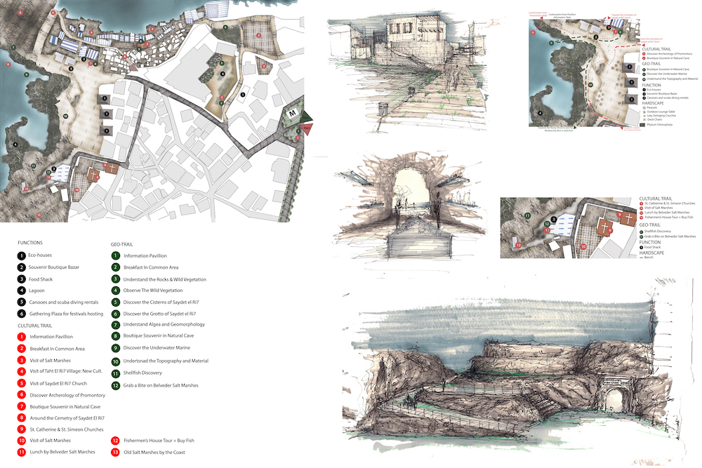
Marine biodiversity
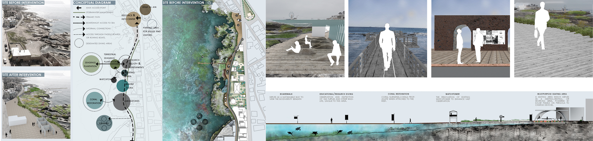
Anfeh consists of a geomorphological richness. At the coastal line, caves, vermited platforms, limestone and sea grass could be observed. The seascapes features have been altered by human intervention over hundreds and thousands of years, and so strategies to maintain their qualities and biodiversity are important. A study on the Lebanese Marine Protected Areas that was conducted in 2014 reports that Anfeh, due to the high human presence, has a medium biodiversity value. In this case an integral protection area would be inoperative. The study suggests some regulated uses (fishing, tourism) and the implementation of mitigation measures to the human impacts (sewage treatment, selective fishing method, no marinas) (RAC/SPA - UNEP/MAP, 2014). The students’ work built on that premises to propose a design intervention focused on preserving the marine biodiversity of Anfeh’s coastal landscape while catering for educational and marine studies activities, and for controlled access to the shore. The design schemes seek to calibrate the tensions between housing development, agricultural practices remains, cultural and biodiversity recognition and protection, proposing adaptive strategies to embed resilient systems. They show the potential of merging ecological and socio temporal activities with the activities of everyday life related to the residential neighborhood. Three components constitute the base of the strategy: marine biodiversity preservation and enhancement; education and research; tourist and local interaction (Figure 11). The marine biodiversity was addressed through a series of interventions directed to re establish ecological processes: coral restoration through coral nurseries to help them to propagate; sea grass harvesting in remediated salt ponds in order to re transplant them into the sea enriching the entire ecosystem; native marine flora plantation in remediated salt ponds; barnacles protection in the existing natural shallow pools to attract birds. Education and research activities were dislocated along the coast with 2 main areas placed in close proximity of Anfeh’s peninsula, and nearby the main marine biodiversity concentration spot. Existing built structures were converted in research center and a series of paths and removable platforms were designed to allocate open air and sea related educational and research activities. The design of controlled access to the seashore through elevated paths and site located gathering and educational areas provides a more organized and regulated tourist and local interaction while enhancing the awareness of the coast biodiversity importance, and informing visitors about the natural resources of Anfeh and the impact that human presence may have on them.
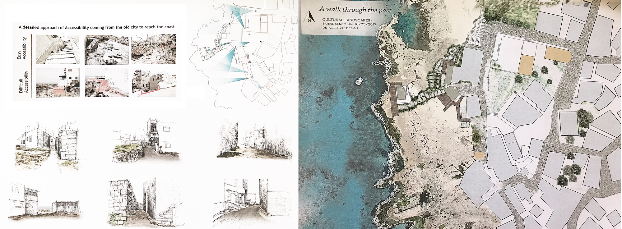
Connection city-Archeology
As mentioned previously in the paper, Anfeh has a rich and extensive presence of archeological remains disseminated all over its territory. The main elements are the peninsula with the ruins of a castle and several byzantine and medieval chapels.
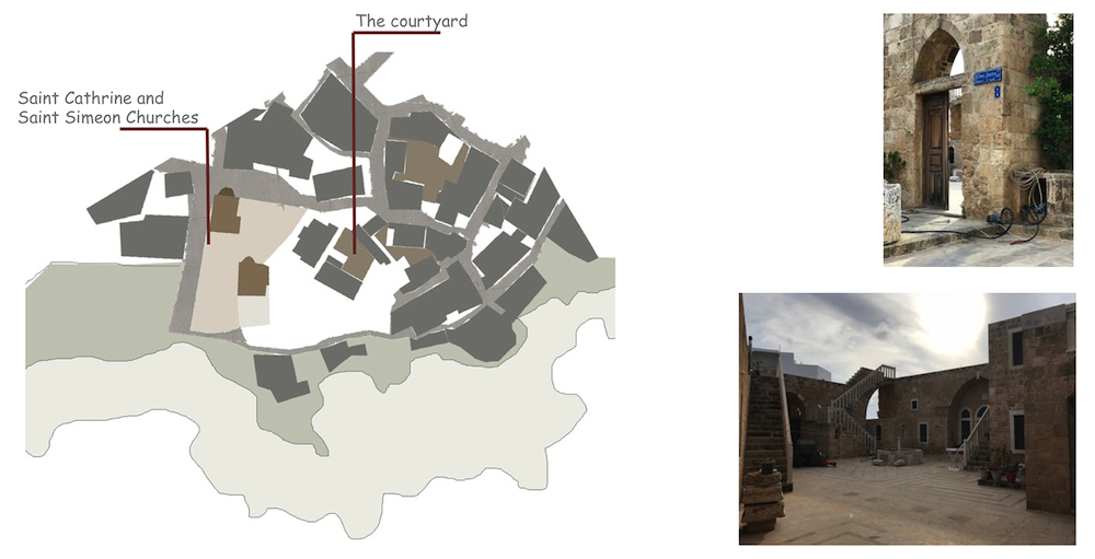
The old city developed around those elements with systems of connectivity and relations that are today totally hidden. Remains of the past character are still visible in the spatial bonds between narrow streets and ancient built structures (Figure 12), in the few examples of the courtyard housing typology, and in the spatial/visual linkage to the sea. The landscape design strategy focused on the enhancement of inherent complexity of the past urban configuration through site catalytic interventions located at the overlap of cultural, environmental and social systems (Briant, Allen, Kebbell, 2017). The ambiguous and unclear connections inland/shore was reconfigured through design actions aiming at reworking the spaces in between: inside/outside, public/private, shaded/open. A system of well identified paths was created to lead the discovery of past and new connections (Figure 13), and of practices related to the sea. Removable platforms and footbridges were positioned along the coast creating access to hidden archeological remains and man-made and natural salt ponds. Lifted up to the shore they frame the view to the sea and to the surroundings providing the coast with punctual observation points and belvederes. These elements are repeated along the coast enforcing and instigating a linear perpendicular access over the rocky shore re-elaborating and reviving the past connection to the sea from the narrow inland paths. The experience of the relation water/settlement is framed around the sensorial discovery of the re-actualized connection (Figure 14). This reconfiguration aims at improving the existing condition of the historical urban morphology of Anfeh while protecting and preserving its complexity and inherent character relating it to the surrounding natural resources. The strategy was grounded on the World Heritage Cities Programme of UNESCO that recognizes the importance of threating the management and conservation of cultural heritage as a whole and not as a sum of individual historical features. Thus realizing the full potential of the landscape as a cultural, educational, intellectual and economic resource and recognizing the historical and geographical connection of the individual features (Whitehand, Gu, 2010).
Conclusion
Coastal landscapes usually comprise a combination of high human population density, overlapping sectors and different interests, with intensive use of space and cultural and natural resources. Using the case of Anfeh’s coastal area as a design exercise, the student’s work explored landscape strategies showing ways of reconfiguring the place’s character re-calibrating past and new identities. Throughout the Mediterranean, coastal landscapes are an important cultural and economic resource. They represent the wealth of natural and human history and, as such, are a cultural artefact worthy of preservation (Vogiatzakis, I.N., Griffiths, G.H., Cassar, L.F. & Morse S., 2005). Grounding the design explorations on the UNESCO recommendation on the HUL approach, the research aimed at reconnecting the different aspect of Anfeh’s heritage — static/dynamic, cultural/natural, tangible/intangible in order to ‘reconnect the city’ (Bandarin, Van Oers, 2015). The local- scale interventions are examples of place related projects that took into account the everyday life and transformation of the site while focusing on the management of its cultural and ecosystem resources. The layered strategies, coupling the on shore interventions with in water actions, proven the capacity of landscape design and planning in recovering and sustainably manage the cultural heritage and the marine biodiversity while strengthening the relationship of the inhabitant with the shoreline through awareness, education, engagement and new economies. Design has the potential to relate and integrate nature-based and socio-cultural issues acknowledging the adaptive capacity of a place. Indeed the cultural design studio at LDEM/AUB suggested that the landscape design's cultural approach has the potential to balance and embed the historic/archeological dimension with the ecological components.
The student’s work lies within the awareness campaigns conducted in the past years by the DAM and others Lebanese organizations to enhance Anfeh’s heritage among the local population and the scientific community. An unexpected outcome of all those efforts was translated in September 2017 by the signing of an agreement between the Anfeh Municipal Council and the Society for the Protection of Nature in Lebanon (SPNL) for the establishment of “HIMA Anfeh”. “Hima” in Arabic means literally “protected place” according to a traditional indigenous system of management and conservation of biodiversity and natural and cultural resources (http://www.birdlife.org/middle-east/projects/hima-traditional-land-designation) It is adapted by the SPNL to the new political, legal and socio-economic realities in order to meet the changing needs of local communities and the demands of modern states, such as decentralization, empowerment of women, education of young people to environmental problems and the need for its safeguard. The student’s projects while combining coastal resiliency infrastructure with habitat-enhancement techniques designed new opportunities for coastal landscape recreation and stewardship.
Acknowledgments
I am grateful to all the people that contributed to this research, challenging and inspiring me with their thought and their practical involvement. In particular I would like to thank Msr. Nahida Khalil, co-instructors of the Cultural Landscape design studio at LDEM, and all the students of the course.
Conflicts of Interest
The authors declare no conflict of interest.
References
- Bandarin, F, and R Van Oers (eds.), (2015). Reconnecting the City: The Historic Urban Landscape Approach and the Future of Urban Heritage. Chichester: John Wiley & Sons
- Beriatos, E., Papageorgiou, M. (2010). Towards Sustainable Urbanization and Spatial Planning of the Coastal Zone in Greece and the Mediterranean Basi 46th ISOCARP Congress 2010. Retrieved from: http://www.isocarp.net/data/case_studies/1727.pdf
- Boissevain, J., & Selwyn, T. (Eds.) (2004). Contesting the foreshore: Tourism, society and politics on the coast. Amsterdam: Amsterdam University Press.
- Brown, G., Hausner, V.E. (2017). An empirical analysis of cultural ecosystem values in coastal landscapes. Ocean & Coastal Management 142. pp. 49-60
- Bryant, M., Allan, P., and Kebbell, S. (2017). A Settlers’ Guide: Designing for Resilience in the Hinterlands. Buildings 2017, 7, 23. pp. 1-15
- CANA-CNRS, (2009). A scientific vessel for Lebanon. Strengthening cooperation between Italy and Lebanon towards the sustainable development of the marine environment. Report. Retrieved from: http://www.aicsbeirut.org/portal/en-US/publications/14/c/cana--cnrs,-a-scientific-vessel-for-lebanon/360/#sthash.D1jAeY1Z.dpbs Accessed on April, 2018
- COASTGAP, 2015. JOINT ACTION PLAN on Med coasts Adaptation to Climate Change Developing conditions for the Blue Growth in the Mediterranean. Retrieved from: http://www.bolognacharter.eu/wp-content/uploads/2016/05/20150206_JAP_BC_COASTGAP_lr.pdf
- Collon, D., and H. Cazelles. (1987). Les lettres d’El Amarna: Correspondance diplomatique du pharaon. Littératures anciennes du Proche-Orient 13. Paris: Cerf.
- The Cultural Landscape Foundation (TCLF) 2016. (n.d.). Retrieved from https://tclf.org/ (Accessed on April 2018)
- Doring, M., Ratter, B. M. W. (2017). Coastal landscapes: The relevance of researching coastscapes for managing coastal change in North Frisia. Cultural geographies of coastal change.
- Edani, H. (2012). Conservation and Management of Cultural Landscapes. Nara National Research Institute for Cultural Properties. http://www.nara.accu.or.jp/elearning/2012/conservation.pdf (accessed on 1 April 2018).
- Egloff, B., & Comer, D.C. (2008). Conserving the Archaeological Soul of Places: Drafting guidelines for the ICAHM Charter. In: 16th ICOMOS General Assembly and International Symposium: ‘Finding the spirit of place – between the tangible and the intangible’, 29 sept – 4 oct 2008, Quebec, Canada. [Conference or Workshop Item] Retrieved from http://openarchive.icomos.org/3/ (Accessed on April 2018)
- El Shaer, H., Samaha, L., Jaradi, G. (2012). Lebanon’s Marine Protected Area Strategy. Supporting the management of important marine habitats and species in Lebanon. Beirut, Lebanon, Gland, Switzerland y Malaga, Spain: the LebaneseMinistry of Environment / IUCN. 64 pp.
- Gesing, F. (2016). Working with nature in Aotearoa New Zealand. An ethnography of coastal protection Transcipt. Bielefeld.
- Ingold, T. (2000). The perception of the Environment. Essays on livelihood, dwelling and skill. Routledge London and New York
- Kalindjian, R. - MISSION ARCHEOLOGIQUE D’ENFEH Volume I : Les prospections terrestres et maritimes et les études ethnographiques, Nadine Panayot Haroun et al. B.A.H. Hors série, in press.
- Lai, F. (2013). Nature and the city: the salt-works park in the urban area of Cagliari (Sardinia, Italy). Journal of Political Ecology Vol. 20, pp. 329-341
- Matless, D. (2001). Landscape and Englishness. London: Reaction Books
- Owaygen, M. (2004). Coastal Area Management Program (CAMP)-Lebanon Thematic Activity: Tourism and Sustainable Development, Final Report. Retrieved from: https://www.pap-thecoastcentre.org/pdfs/Tourism%20FINAL%20Report.pdf
- Palang, H., & Fry, G. (2003). Landscape Interfaces: Cultural Heritage in Changing Landscapes. doi:10.1007/978-94-017-0189-1
- Panayot, N. H. (2015). Anfeh Unveiled: Historical Background, Ongoing Research, and Future Prospects. Journal of Eastern Mediterranean Archaeology and Heritage Studies, 3:4, pp. 396-415
- Panayot, N. H. et al (2016) “Les résultats préliminaires des fouilles à Enfeh, 2011-2015”, BAAL
- Panayot and Semaan (2017). Preserving the Landscape of Anfeh: From Nature to Culture; Conference: “Maritime Archaeology of the Mediterranean”; The Honor Frost Foundation and the University of Cyprus; Nicosia, Cyprus; 19-25 October 2017, in press.
- Petanidou, T. (2004). Salinas of the Mediterranean - past and futures. Retrieved from http://www1.aegean.gr/alas/book_pdfs/introduction.pdf (Accessed on April 2018)
- RAC/SPA - UNEP/MAP, (2014). Ecological characterization of sites of interest for conservation in Lebanon: Enfeh Peninsula, Ras Chekaa cliffs, Raoucheh, Saida, Tyre and Nakoura. By Ramos-Esplá A.A., Bitar G., Khalaf G., El Shaer H., Forcada A., Limam A., Ocaña O., Sghaier Y.R. & Valle C. Ed. RAC/SPA - MedMPAnet Project, Tunis: 146 p + annexes.
- Ratter, B., & Gee, K. (2012). ‘Heimat’: A German concept of regional perception and identity as a basis for coastal management in the Wadden Sea. Ocean and Coastal Management, 68, 127–137.
- Rayan, A. (2012). Where Land Meets Sea Coastal Explorations of Landscape, Representation and Spatial Experience. Routledge, London and New York
- Salamé-Sarkis, H. (1987). Matériaux pour une histoire de Batrūn. Berytus 35:101–19.
- Salizzoni, E. (2012). Tourism and biodiversity along the Euro-Mediterranean Coast: prospects for overcoming a deeply rooted conflict. Parks Vol 18.2. pp. 45-53
- Sauer, C. O. (1925). "The Morphology of Landscape". University of California Publications in Geography 2 (2):19-53.
- Selman, P. (2009). Planning for Landscape Multifunctionality Sustainability. Science, Practice and Policy, 5 (2). pp. 45-52
- Tartaron, T. F. (2013). Maritime Networks in the Mycenaean World. New York: Cambridge University Press
- Taylor, K. & Lennon, J. (2011) Cultural landscapes: a bridge between culture and nature?, International Journal of Heritage Studies, 17:6, 537 554, DOI: 10.1080/13527258.2011.618246
- UNESCO Recommendation on the Historic Urban Landscape (HUL), November 2011, https://whc.unesco.org/uploads/activities/documents/activity-638-98.pdf
- Visser, L. (Ed.) (2004). Challenging coasts. Transdisciplinary excursions into integrated coastal zone development. Amsterdam: Amsterdam University Press. Freya, A. (1972). A dictionary of the names of towns and villages in Lebanon (Arabic). Beirut: Librairies du Liban
- Vogiatzakis, I.N., Griffiths, G.H., Cassar, L.F. & Morse S. (2005). Mediterranean Coastal Landscapes. Management Practices, Typology and Sustainability. Final Report. Retrieved from: https://www.researchgate.net/publication/315767164_MEDITERRANEAN_COASTAL_LANDSCAPES_Management_Practices_Typology_and_Sustainability_FINAL_REPORT
- Whitehand, J. W. R., Gu, K. (2010). Conserving Urban Landscape Heritage: a Geographical Approach. Procedia Social and Behavioral Sciences 2 (2010) 6948–6953