Spatial Distribution and Connectivity of Eco-Cultural Resources on Cheongsando Island, Republic of Korea
Institution for Marine and Island Cultures, Mokpo National University, Republic of Korea ecokimje@gmail.com
Abstract
Cheongsando, located in Wando-gun, Jeollanamdo, is designated as being part of the Dadohaehaesang National Park. The island is also designated as Asia's first “Slow City” and its traditional Gudeuljang irrigated rice terraces are officially listed as a Globally Important Agricultural Heritage System. This has resulted in the creation of a “Slow Walking Trail”, linking various eco-cultural resources. However, in its current configuration the Slow Walking Trail network fails to connect all parts of the islands equally well, causing regional imbalance and dissatisfaction among residents. To overcome these issues and improve the connectivity between villages, this study aimed to identify ways to refine the Slow Walking Trail network by means of a least cost path analysis. The results show that land use patterns such as rice paddy field, grassland, and road shape are the low cost land use patterns for network connection. Moreover, the analysis shows that the existing network forms a useful basis for refinements as there are sufficient similarities to the connected network identified by the least cost path analysis. In the end, the already established and used small road will have an important influence on the connected villages and improving the network.
Keywords
Least cost path, Cheongsando, Network, Eco-cultural tourism, Small road
Introduction
Cheongsando has a beautiful natural landscape and excellent cultural scenery in Korea. It was designated as part of the Dadohaehaesang National Park on December 23, 1981. In addition, it was designated as “national important agricultural heritage No. 1” given its traditional Gudeuljang irrigated rice terraces that were created to overcome the barren natural environment.
It was designated as the first “Slow City” in Asia in 2007 and the first “Globally Important Agricultural Heritage System” (GIAHS) in Korea in 2014. With its natural beauty and good agricultural culture, Cheongsando is regarded as having excellent cultural values developed by human adaptation to nature.
In fact, the islands Jeungdo and Cheongsando, both designated as Slow City, have been developing at a much higher rate than other places, and research has shown that the brand "slow city" has a significant effect on the destination selection of tourists (Han and Hyun, 2016). In addition, due to the increasing demand for eco-cultural tourism and the increase of family tourists due to changes in tourism patterns in Korea (Kim, 2011), Cheongsando is a well-known sightseeing spot.
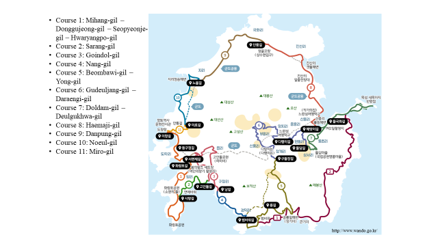
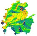
Tourist information and maps of Cheongsando list representative tourism resources that people can visit in Cheongsando, consisting of the eleven-course Slow Walking Trail network, seven mountain climbing routes, and mountain climbing courses (Figure 1). Eco-cultural resources for tourism are plentiful but scattered. Looking at the spatial distribution of these tourist sites, most of them are only around Eub-li in the west, Buheung-li in the east, Jungheung-li, and Shinheung-li.
Various eco-cultural resources are developed in places accessible by major roads, a practice that goes against the basic idea of the Slow Walking Trail network. Furthermore, the network includes some roads that are dangerous for walking due to the presence of motorized traffic and some roads that can cause seasonal discomfort because they do not offer shade in hot summer.
Therefore, this study will examine the status and distribution characteristics of eco-cultural resources in Cheongsando, known as a successful example of eco-cultural tourism in a Slow City. GIS information was analyzed to identify the spatial distribution characteristics of resources for sustainable eco-cultural tourism. In addition, a Least-Cost Path Analysis was conducted to assess how to best connect the eco-cultural resources with each other (Kim et al., 2012).
Study areas and Methods
1. Study area
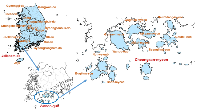
Wando County is administratively composed of three towns (Wando-eub, Nohwa-eub, and Geumil-eub) and nine townships (Gunoe-myeon, Gogeum-myeon, Yaksan-myeon, Shinji-myeon, Geumdang-myeon, Saengil-myeon, Bogil-myeon, Soan-myeon, and Cheongsan-myeon)2. As Figure 2 shows, Nohwa-eub, Bogil-myeon, Soan-myeon, and Cheongsan-myeon are located to the south of the other areas. There are five inhabited islands: Cheongsando, Daemodo, Somodo, Yeoseodo, and Jangdo. The other six islands are uninhabited3.
Cheongsando consists of eleven “-li” (Table 1, second column) a local areal unit that is also taken as the level of analysis in the current study. In practice, some “-li” areas are subdivided into smaller “-li” for administrative reasons (Table 1, third column). The island is located at a considerable distance from the mainland and its natural environment is better preserved than in other places. It is the first place in Korea of which the ecological culture of local residents was specified as a Globally Important Agricultural Heritage System (GIAHS) in 2014.
| Number | Legislative division | Administrative division |
|---|---|---|
| 1 | Guksan-li | Gukhwa-li, Jinsan-li |
| 2 | Danglak-li | Dang-li, Dolak-li |
| 3 | Docheong-li | Docheong-1-li, Docheong-2-li |
| 4 | Dongchon-li | Dongchon-li |
| 5 | Buheung-li | Buheung-li, Shinpung-li |
| 6 | Sangdo-li | Sangseo-li, Wondong-li |
| 7 | Shinheung-li | Shinheung-li |
| 8 | Yangjung-li | Yangji-li, Jungheung-li |
| 9 | Eub-li | Gujang-li, Gwondeok-li, Eub-li |
| 10 | Ji-li | Ji-li |
| 11 | Cheonggye-li | Cheonggye-li |
Data of the Gwangju Regional Meteorological Administration shows that Wando County, over the past 30 years, had an average precipitation of 1532.7 mm annually with an average of 110 days of precipitation per year. The average rainfall in July amounted to 285.7 mm, whereas in December only 27.4 mm of rainfall was recorded on average. The annual mean temperature was 14.1ºC, and very rarely the average monthly temperature dropped below zero. In summer, the highest temperature was relatively low compared to other regions, and the lowest temperature in winter characterizes a mild oceanic climate. Given its geographical location, south-east winds cause Wando to experience a longer fetch4 and higher waves.
| Element | January | February | March | April | May | June | July | August | September | October | November | December |
|---|---|---|---|---|---|---|---|---|---|---|---|---|
| Mean temperature (ºC) | 2.6 | 3.9 | 7.5 | 12.7 | 17.1 | 20.7 | 24.3 | 25.7 | 22.2 | 16.9 | 10.7 | 5.1 |
| Maximum temperature (ºC) | 6.1 | 7.9 | 11.8 | 17.3 | 21.4 | 24.6 | 27.5 | 29.2 | 26.1 | 21.2 | 14.8 | 9.0 |
| Minimum temperature (ºC) | -0.4 | 0.5 | 3.8 | 8.6 | 13.3 | 17.6 | 21.8 | 23.1 | 19.2 | 13.3 | 7.1 | 1.8 |
| Precipitation (mm) | 34.2 | 52.8 | 95.5 | 119.2 | 135.4 | 243.0 | 285.7 | 243.6 | 182.1 | 56.5 | 57.2 | 27.4 |
| Precipitation duration (hr) | 65.2 | 68.6 | 74.8 | 71.8 | 82.9 | 103.2 | 99.9 | 68.6 | 68.0 | 34.7 | 43.6 | 49.4 |
| Small evaporation amount (mm) | 65.9 | 68.3 | 99.3 | 125.1 | 144.5 | 127.7 | 132.3 | 171.0 | 129.9 | 127.9 | 87.8 | 67.2 |
| Mean wind speed (m/s) | 4.8 | 4.7 | 4.2 | 3.6 | 3.1 | 2.8 | 2.9 | 2.9 | 3.0 | 3.4 | 3.7 | 4.3 |
| Average humidity (%) | 67.0 | 66.4 | 66.4 | 67.5 | 73.0 | 80.0 | 85.6 | 82.2 | 76.5 | 69.5 | 68.6 | 67.9 |
| Average vapor pressure (hPa) | 5.1 | 5.6 | 7.1 | 10.1 | 14.2 | 19.5 | 26.1 | 27.2 | 20.7 | 13.6 | 9.2 | 6.2 |
| Duration of fog (hr) | 0.96 | 1.92 | 4.20 | 6.35 | 13.77 | 20.77 | 29.51 | 4.04 | 2.39 | 2.19 | 2.92 | 2.13 |
| Total cloud amount (oktas) | 4.8 | 4.8 | 5.2 | 5.0 | 5.4 | 6.7 | 7.2 | 5.9 | 5.6 | 4.0 | 4.2 | 4.4 |
| Pressure of the atmosphere at the sea-level (hPa) | 1024.4 | 1022.8 | 1019.7 | 1015.7 | 1011.9 | 1008.1 | 1007.1 | 1008.3 | 1013.0 | 1018.8 | 1022.4 | 1024.5 |
| Minimum grass temperature (ºC) | -3.2 | -2.5 | 1.0 | 5.6 | 11.1 | 16.3 | 20.8 | 21.6 | 17.0 | 10.1 | 3.1 | -1.8 |
| Ground surface temperature (ºC) | 2.2 | 4.5 | 9.0 | 15.4 | 21.0 | 25.0 | 27.7 | 29.4 | 24.9 | 18.0 | 9.7 | 3.9 |
| Number of precipitation days (more than 0.1mm) | 8.2 | 7.5 | 9.7 | 9.0 | 9.5 | 11.3 | 13.5 | 11.6 | 9.0 | 5.9 | 7.6 | 7.3 |
| Number of precipitation days (more than 1.0mm) | 4.6 | 5.2 | 7.2 | 7.2 | 7.6 | 9.0 | 10.7 | 9.4 | 6.9 | 4.2 | 4.8 | 3.7 |
| Number of days with storm | 4.1 | 3.8 | 2.9 | 1.8 | 0.7 | 0.2 | 0.6 | 1.0 | 0.6 | 1.3 | 2.3 | 3.2 |
| Number of sunless days | 4.0 | 4.1 | 4.9 | 4.3 | 6.0 | 7.5 | 6.9 | 4.1 | 5.3 | 2.7 | 3.1 | 3.1 |
2. Methods
1) Analysis of Land Use and Spatial Distribution of Eco-Cultural Resources
Land use is a very important aspect that shows the diverse cultural characteristics of a landscape, including the socio-economic characteristics of an area5.(Forman, 1994; Kim et al., 2006). To examine the socio-economic characteristics of Cheongsando and to investigate the land use pattern of the island, the landscape elements were analyzed with inclusion of land cover. This was overlaid by road data and “Li” geographical boundaries to assess how eco-cultural tourism resources are distributed and whether they are accessible or not.
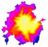
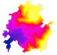
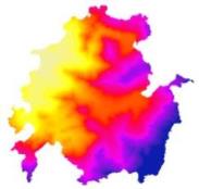
By using DEM (Digital Elevation Model) and topographical data of Cheongsando, the topography of Cheongsando was digitally reconstructed into a 3D representation to examine the geographical features and the distribution characteristics of eco-cultural resources in more detail. The DEM can readily serve as a gradient (or cost factor) in the least-cost path analysis while it enables visualizing the topography of Cheongsando.
2) Least Cost Path Analysis
Least cost path analysis is a model to analyze the shortest distance between two points using the “path” that costs the least, with the costs being a function of time, distance or other criteria. Nowadays, it is widely used in many different fields, primarily for designing and evaluating networks of any kind. For example, least cost path analysis is used as a means for pioneering a trail, opening a road, or examining human movement (Kim et al., 2012). Calculation of the least cost path between points requires two types of input:
- Cost Distance: Cost distance is the cost paid according to distance when moving from one cell in a raster to another.
- Cost Back Link: Cost back link identifies the neighboring cell that is next on the least-accumulative cost path to the nearest source in a raster (Figure 3).
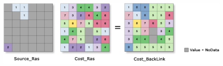
Given these two inputs it is possible to conduct least cost path analysis. In most cases, land use or terrain often accounts for a large part of the costs even in the case of Cheongsando, there is a possibility of high costs for route creation because of the mountainous terrain. The model is examined by judging how the topography affects cost incidence in the least-cost path analysis.
There are twenty-three sites identified on the Cheongsando tourist information map, such as Docheong-li that includes the ship port where the overall majority of tourists set foot on the island. As the aim is to examine the connectivity between all these sites, they are interpreted as the nodes of the network that is to be analyzed. This implies that the site locations are identified as point data to prevent duplication.
Results
1. Land Use and Spatial Distribution
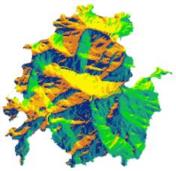
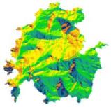
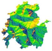
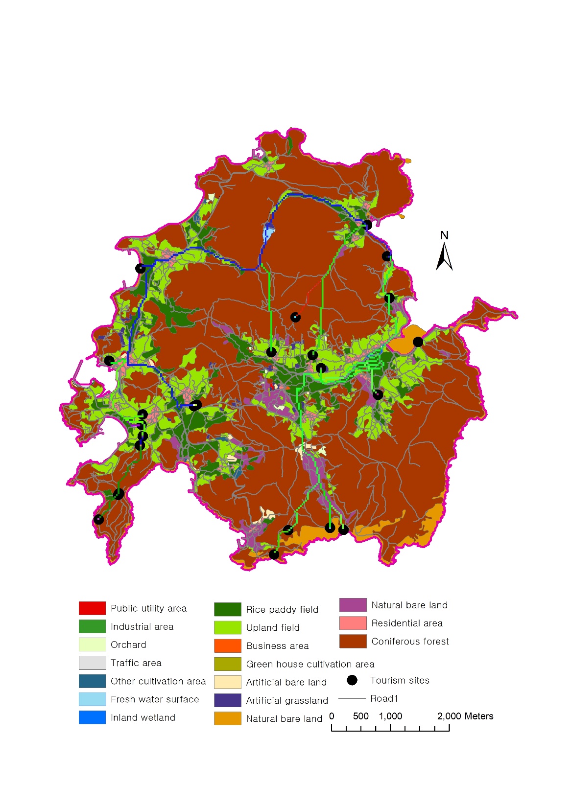
Figure 4 shows the land use pattern in Cheongsando, identifying seventeen land use types. Given the types found, it is possible to distinguish five major land uses: urbanized area, water surface, cultivation, natural area, and other uses. The total area of Cheongsando is around 33.9 km2 (Table 3). Coniferous forests, upland fields and rice paddy fields are the land use types covering the largest areas. Conifers occupied nearly 22 km2, which is almost 65% of the whole island. This is a rich ecological resource that is protected as part of the Dadohaehaesang National Park.
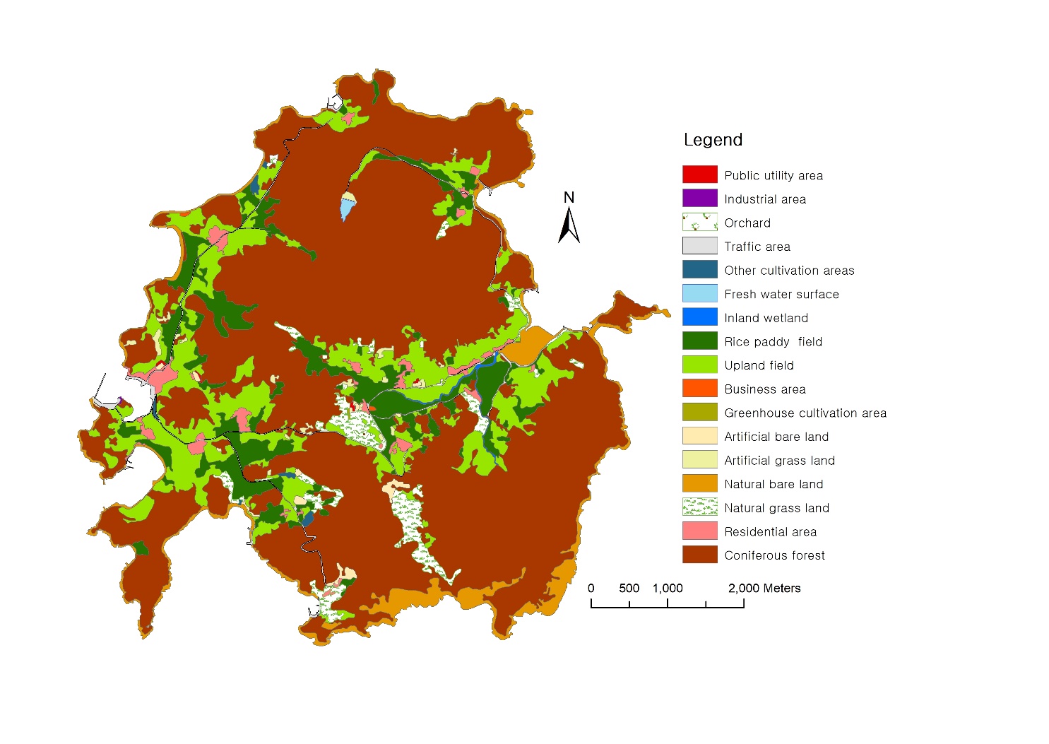
| Contents | Area (m2) | % | |
|---|---|---|---|
| Urbanized area | Public utility area | 17,603.5 | 0.05 |
| Industrial area | 2,727.3 | 0.01 | |
| Orchard | 52,183.5 | 0.15 | |
| Traffic area | 351,457.7 | 1.04 | |
| Business area | 12,881.1 | 0.04 | |
| Residential area | 537,496.4 | 1.58 | |
| Water surface | Fresh water surface | 31,678.4 | 0.09 |
| Inland wetland | 53,487.7 | 0.16 | |
| Cultivation | Rice paddy field | 2,811,991.7 | 8.29 |
| Upland field | 4,968,378.5 | 14.65 | |
| Green house cultivation area | 3,911.9 | 0.01 | |
| Other cultivation area | 67,995.6 | 0.20 | |
| Others | Artificial bare land | 143,726.9 | 0.42 |
| Natural bare land | 1,796,696.2 | 5.30 | |
| Natural area | Artificial grassland | 145,476.9 | 0.43 |
| Natural grassland | 930,391.6 | 2.74 | |
| Coniferous forest | 21,986,415.7 | 64.83 | |
| Total | 33,914,500.5 | 100.00 | |
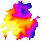
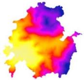
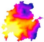
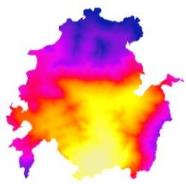
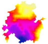
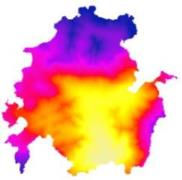
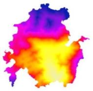
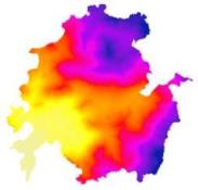
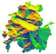
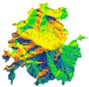
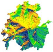
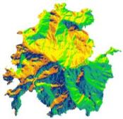
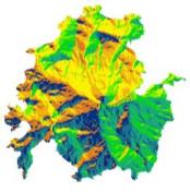
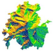
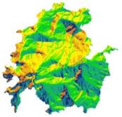
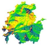
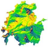
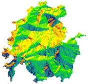
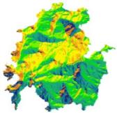
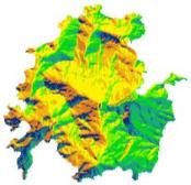
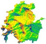
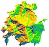
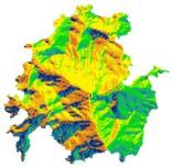
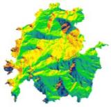
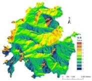
Figure 5 shows the three-dimensional topography of Cheongsando. Cheongsando has a continuously connected mountain range curving from the north to the south, with mountains named Mt. Mabong, Bojeok, Goseong, Daeseon, Daesong, and Daebong. The tourism resources in Cheongsando (Figure 1) are mostly located in the villages of Buheung-li and Yangjung-li where major roads pass through, including Buheung-li and Yangheung-li in the west and Docheong-li in the east.
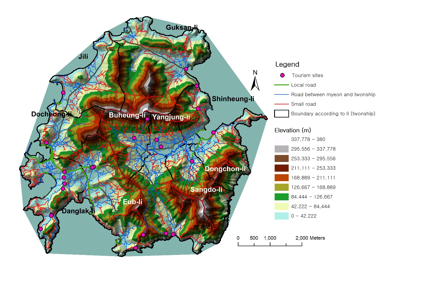
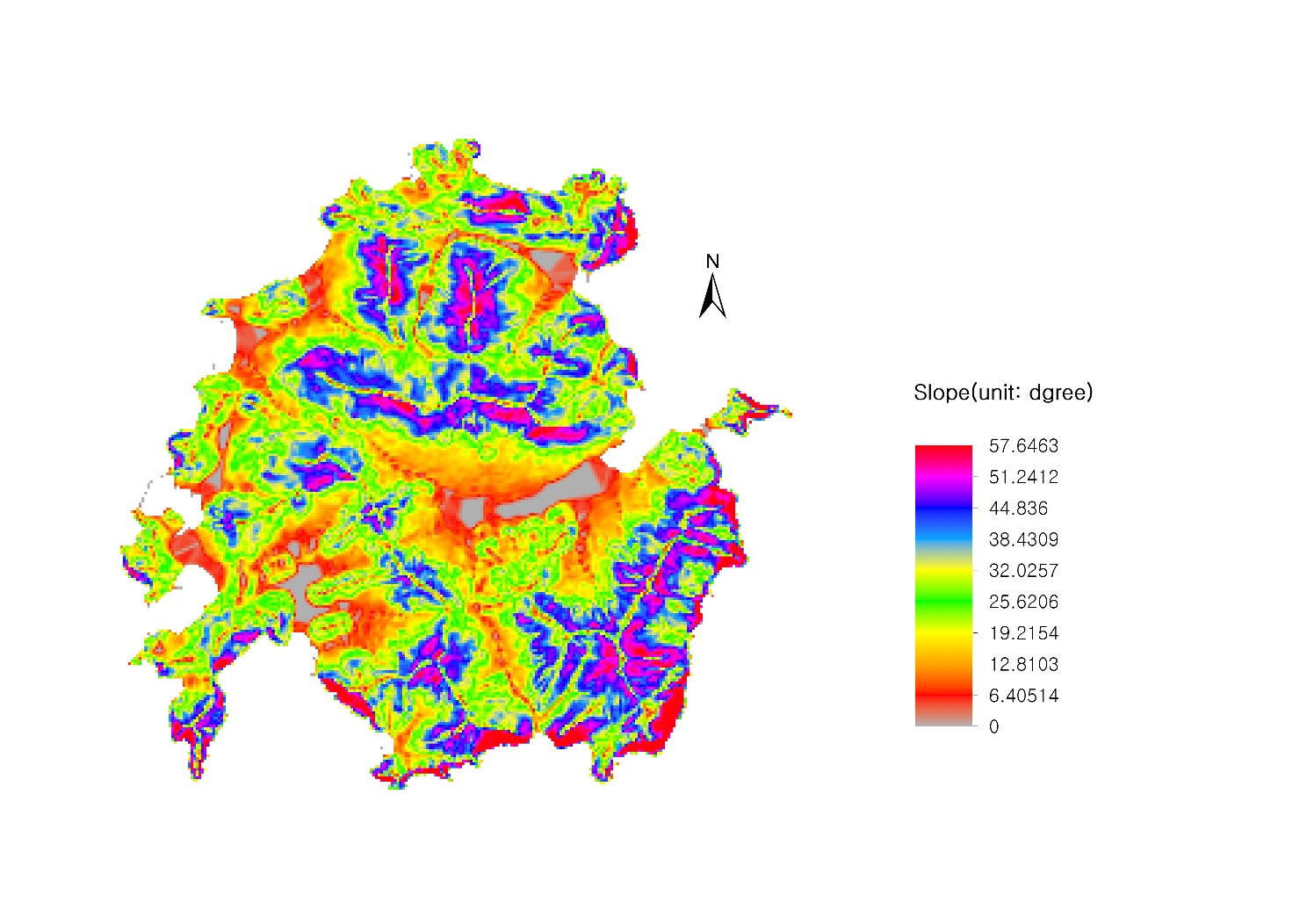
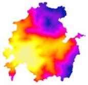
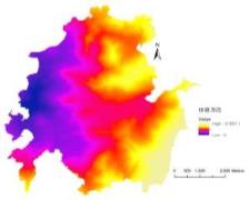
Figure 6 shows the slopes in terrain using DEM. It reveals that slopes are very steep near mountain tops and that southern coast of Cheongsando is rather inaccessible because of cliffs with a very steep slope.
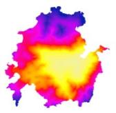
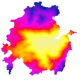
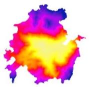
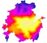
2. Least Cost Path Analysis
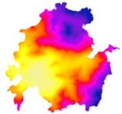
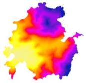
Figure 7 shows the results of the cost distance analysis of the 22 eco-cultural tourism resources known to the general public through the Cheongsando tourist information map. It can be seen that the higher the distance from the location where the resources are located, the higher the cost. Figure 8 shows the results of the cost back link analysis for each eco-cultural tourism resource.
 |
 |
 |
 |
| Jinsan-li Sunrise Observatory 진산리일출전망대 |
Shinheung-li Beach 신흥리 해수욕장 |
Myeongpum Maeul 국립공원 명품마을 돌담 |
Excursion School to a Slow Island 느린섬 여행학교 |
 |
 |
 |
 |
| Sungmosa 숭모사 |
Gudeuljangnon rice paddy 구들장논체험장 |
Baeklyeonam 백련암 |
Hamabi 하마비 |
 |
 |
 |
 |
| Dolmen 고인돌 |
Cheongsanjiseong 청산지성 |
Spring Waltz Drama Location 봄의 왈츠 드라마 촬영지 |
Seohyeonje Film Location 서편제영화촬영지 |
 |
 |
 |
 |
| Scent of a Woman Drama Location 여인의 향기 촬영지 |
Beombawi Rock 범바위 |
Maltanbawi Rock 말탄바위 |
Kalbawi Rock 칼바위 |
 |
 |
 |
 |
| Janggimi Beach 장기미해변 |
Hwalangpo Obervatory 화랑포 전망대 |
Chobun (Temporary cemetery) 초분 |
Hwalangpo Park 화랑포 공원 |
 |
 |
||
| Jiri Beach 지리 해수욕장 |
Native history and culture exhibition hall 향토역사문화전시관 |
||
 |
 |
 |
 |
| Jinsan-li Sunrise Observatory 진산리일출전망대 |
Shinheung-li Beach 신흥리 해수욕장 |
Myeongpum Maeul 국립공원 명품마을 돌담 |
Excursion School to a Slow Island 느린섬 여행학교 |
 |
 |
 |
 |
| Sungmosa 숭모사 |
Gudeuljangnon rice paddy 구들장논체험장 |
Baeklyeonam 백련암 |
Hamabi 하마비 |
 |
 |
 |
 |
| Dolmen 고인돌 |
Cheongsanjiseong 청산지성 |
Spring Waltz Drama Location 봄의 왈츠 드라마 촬영지 |
Seohyeonje Film Location 서편제영화촬영지 |
 |
 |
 |
 |
| Scent of a Woman Drama Location 여인의 향기 촬영지 |
Beombawi Rock 범바위 |
Maltanbawi Rock 말탄바위 |
Kalbawi Rock 칼바위 |
 |
 |
 |
 |
| Janggimi Beach 장기미해변 |
Hwalangpo Obervatory 화랑포 전망대 |
Chobun (Temporary cemetery) 초분 |
Hwalangpo Park 화랑포 공원 |
 |
 |
||
| Jiri Beach 지리 해수욕장 |
Native history and culture exhibition hall 향토역사문화전시관 |
||
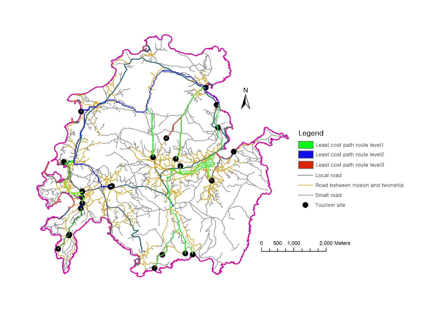
The result from the least cost path analysis is shown in Figure 9. The identified path is a route that mostly leads through rice paddy fields, upland fields, natural grasslands, artificial pastures, and residential areas. Most of these land uses do not come with steep slopes and they are relatively easy to pass through compared to other land uses. It can also be seen that there are small roads near the least cost path at several places.
Discussion
1. Least cost path analysis and use of small roads
One of the major tourism destinations on Cheongsando is in the west at Dangnak-li, which is famous for film and drama recordings in the downtown area where ships come in. With the main roads as the center, one can see the Gudeuljangnon rice paddy, the slow food experiences, and the national parks designated by farming heritage, slow city, sightseeing sites, and so on. Except for hiking trails and the 11-course Slow Walking Trail, it is a continuous forest that stretches to the south of Cheongsando, so most tourists go to the east by car. Cars are generally used for sightseeing across the island, which reduces the chance of fully enjoying the area or spending money compared to sightseeing on foot.
Cheongsando is considered to be an important example of eco-cultural tourism success with its designation as Slow City (Lee et al., 2016). However, it is a reality that the number of tourists is recently stagnating and the dissatisfaction among local residents is becoming more evident (Jeong et al., 2016). In answer to these problems, it appears necessary to improve the accessibility for tourists and develop diverse programs in underprivileged areas.
The least cost path analysis provides insight into how the connectivity between eco-cultural tourism resources could be improved and this provides a, perhaps more convenient, alternative for both local residents and visitors. As the results show, the least cost route traverses mostly rice paddy fields, upland fields, residential areas, grasslands, and so on, which are easier to access than some other types of land use. In addition, it is considered to be advantageous to utilize the least cost path because of the presence of many small roads in its direct vicinity. Some parts of the existing Slow Walking Trail overlap with main roads, which has a negative effect on traffic safety. Small roads with less traffic at lower speeds are likely to be more secure.
Figure 10 shows the road network of Cheongsando and the map of the least-cost path. The main roads with separated lanes, the average roads and small roads are well developed with a total length of about 300 km. Using the current road network, it is possible to create various programs effectively and quickly. Moreover, it is necessary to consider the effects of seasonal changes in the configuration of the walking trail and to prepare roadside trees so as to provide sufficient shade in summer. In case of the Slow Walking Trail, which is not visited often, there may be a problem in safety, so continuous management will be needed. Looking at the connection through the least-cost path analysis, it is possible to utilize existing (small) roads, to reduce costs, and to provide more diverse walking tourism resources.
2. Using coniferous forests
As part of a national park, Cheongsando has a well-preserved coniferous forest that occupies more than 60% of the total area. In coniferous forests, phytoncide is emitted twice as much as in broad-leaved forests and it is known to be released more in spring and summer. Phytoncide is known as a substance that plants produce to protect themselves from various pathogens, pests, and fungi (Forest Service, http://www.forest.go.kr). Recently, phytoncide has become popular with people for its supportive health benefits such as improving cardiopulmonary function, strengthening immunity, and sterilizing action. Overall, many people visit forests for their daily health, such as stress relief.
Cheongsando, having such an important large-scale resource, can provide a more diverse visitor program through the use of ecological resources. Although there are many visitors to visit Cheongsando for the purpose of climbing, there is a place where visitors can experience forest baths that are accessible for visitors who do not want to do climbing or similar vigorous activities. Such places allow them to spend their time on the island through experiential programs. According to Kim and Ahn (2010), experiential programs can actually improve visitors’ consumption.
Finally, this study has applied a least cost path analysis as a model for improving accessibility through network construction between eco-cultural resources in Cheongsando. Also, by analyzing the characteristics of the spatial distribution of eco-cultural resources, it has offered insights based on which suggestions can be made for alternatives for allocating resources and utilizing new spatial resources.
Acknowledgements
This paper was supported by the National Research Foundation of Korea Grant funded by the Korean Government (MEST) (NRF-2009-361-A00007).
Endnotes
References
- Cho, J.S., 2009. Strategies for promoting the sustainable island tourism though the analysis of tourist behaviors -in case of Cheongsando, county Wando, Korea. Journal of The Korean Regional Development Association 21(9), 151-176 (in Korean with English abstract).
- Forman, R.T.T., 1995. Land Mosaics: the ecology of landscape and Regions. Cambridge University Press, Cambridge.
- Han, J.S., Hyun, Y.H., 2016. An Examination of the Structural Relationships among Brand Recognition, Destination Image and Destination Loyalty: A Case of the Slow City Chungsando Visitors. Journal of Tourism Sciences 34(6), 273-290 (in Korean with English abstract).
- Hong, S.-K., Kim, J.-E., 2008. Applying Geographical Information System and Landscape Indices to Landscape Ecological Analysis of Maritime Village in Korea -Case studies on Fishery Villages in Tae-An Peninsula Chungnam. Journal of the Island Culture 31, 281-29 9(in Korean with English abstract).
- Jung, S.-M., Yang, C.-H., Kang, S.-K., 2016. The Attitude of Local Residents Toward the Slow City Project in Terms of Tourism Resources: Based on Chungsando Island, a Slow City in Korea. Journal of Tourism Sciences 40(7), 149-163 (in Korean with English abstract).
- Kim, J.-E., 2017. The discussion of sun-dried salt field and eco-cultural resources utilization in Jeungdo and Shineuido, Shinan County, Jeonnam. Journal of Korean Island 29(1), 309-330 (in Korean with English abstract).
- Kim, J-E., Hong, S.K., Nakagoshi, N., 2012. Green network analysis in coastal cities using least-cost path analysis: A study of Jakarta, Indonesia. Journal of Ecology and Environment 35(2), 141-147.
- Kim, J-E., 2011. Ecosystem services and environmental policies on islands. Journal of the Island Culture 37, 267-281.
- Kim, J-Y., Ahn, K-M., 2010. An analysis of visitors’ consuming behavior in Hwacheon Sancheoneo Festival. The Journal of Hospitality and Tourism 19(4), 247-260 (in Korean with English abstract).
- Korea Meteorological Administration. 06/07/2017. http://www.kma.go.kr/weather/climate/ (in Korean)
- Korea Forest Service. 24/08/2017. http://www.forest.go.kr (in Korean)
- Lee, D.-K., Song, W.-K., Jeon, S.-W., 2008. Regional Ecological Network Design for Wild Animals` Movement Using Landscape Permeability and Least-cost Path Methods in the Metropolitan Area of Korea. J. Korean Env. Res. & Reveg. Tech. 11(3), 94-106 (in Korean with English abstract).
- Lee, D.-S., 2007. A study on the developmental valuableness of tourist resources in Cheongsando. The Journal of Korean Island 19(2), 19-44 (in Korean with English abstract).
- Lee, J.H., Lee, J.H., Hwang, D.H., 2016. Island Tourism Success Factors: A Comparison between Jeungdo and Chungsando, Korea. Journal of Tourism Sciences 40(2), 159-179 (in Korean with English abstract).
- Luchman H., Hong, S.-K., Kim, J.-E., Nakagoshi N., 2008.Tourism and Cultural Landscape at the Tengger, East Java, Indonesia: The Implications for Ecotourism Planning. Korean Journal of Environment and Ecology 22(3), 207-220.
- Naveh, Z., Lieberman, A., 1994. Landscape ecology: theory and applications, 2nd ed. Springer, New York.
- Oh, D.H., Hong, J.U., 2009. A study on slow city’s development direction suitable to Korea. The Journal of the Korean Urban Administration Association 22(3), 267-294 (in Korean with English abstract).
- Turner, M.G., Gardner, R.H., O’Neill, R.V., 2001. Landscape ecology in theory and practice. Springer, New York.