Land use patterns and landscape structures on the islands in Jeonnam Province’s Shinan County occasioned by the construction of mainland bridges1
Institution for Marine and Island Cultures, Mokpo National University, 11, Songnim-ro 41 beon-gil, Mokpo, Jellanamdo 58645, Republic of Korea ecokimje@gmail.com
Abstract
Land use in a specific region reflects the prevailing socioeconomic circumstances and cultures within that region. To this end, the current study analyzes the landscape structure of Shinan County using landscape indices based on land use to compare various socio-economic factors of the culture found on the islands of Shinan County. In addition, a cluster analysis was conducted to learn about the characteristics of islands exhibiting the same landscape structure. This analysis revealed that the landscape of the second largest island in Shinan County, Jido, was more fragmented than that of the biggest island Aphae. The cluster analysis led to the creation of three groups of islands exhibiting similar landscape structures. Group 1 is composed of the islands which are connected by a mainland bridge (called ‘yeonyukgyo’ in Korean). Group 2 and 3 also include the upper islands (those islands located in the northern area) and lower islands (those islands located in the southern area) in Shinan County. The presence of more advanced transportation systems and structures occasioned by their proximity to the island of Jido which was connected at an early date to the mainland ensured that the upper islands have historically been more frequently visited.
Keywords
Bridge, Cluster analysis, Islands, Landscape structure, Land use, Mainland bridge
Introduction
Surrounded by water, islands are by nature difficult to access. This reality has historically led the residents of islands hard-pressed to secure resources from the outside world searching for various methods to use the natural resources at their disposal. As a result, numerous unique cultures were created during the process of preserving such systems (Baldacchino, 2007b; Kim, 2013). Over time, islands began to boast characteristics that differed from the mainland in both a biological and cultural manner, to the extent that, based on the physical characteristics of islands, the word ‘islander’ emerged to refer to people residing on islands (Ryan, 2010; Baldacchino, 2007a). Eco-cultural and socio-economic characteristics of a certain region are represented well through the landscape structure (Forman, 1995; Turner et al., 2001).
Recently, governments have constructed the bridges in islands to relieve the traffic inconvenience and due to development pressures.
The construction of mainland bridges has been perceived as an essential factor that has helped improve the convenience and quality of life of island residents. Nevertheless, discussion of the characteristics of islands from the standpoint of their geological characteristics has been limited. More to the point, there has been a serious lack of attention paid to the stories of islanders’ lives that is rooted in an understanding of the various biospecies and unique culture prevailing on their respective islands. The numerous islands of Shinan County, Jellanamdo province have traditionally been home to a wide variety of biospecies and cultural characteristics (Kim, 2015). However, the construction of mainland bridges has had an indelible impact on such biospecies and cultures (Karr, 1982).
In particular, the construction has taken place in various situations of socio-economic changes such as population decrease, number of tourists changes and so on.
The construction of mainland bridges led to the emergence of development pressures from the mainland. This is evidenced by a look at land use patterns, and an analysis of the landscape structures rooted in these land use patterns (Szabó et al., 2008; Turner et al., 2001). Land use patterns can be used to explain the characteristics of an area’s spatial use by demarcating the landscape characteristics of different areas. Land use serves as an important tool in terms of exhibiting the socioeconomic characteristics of an area (Forman, 1995; Kim, 2013; Turner et al., 2001). It can also be utilized to read and analyze the social and economic changes based on land use patterns. Land use patterns also serve as an implement to predict long-term landscape changes.
Socio-economical changes by bridge constructions have already been discussed in studies outside Asia (Baldacchino, 2007a,b). Research focusing on the specific case of Korea, however, appears to be missing. Therefore, this study analyzes the landscape structures of the main islands in Shinan County based on changes in land use patterns, and discusses the influences of mainland bridge construction based on an analysis of similarities in landscape structures of these islands.
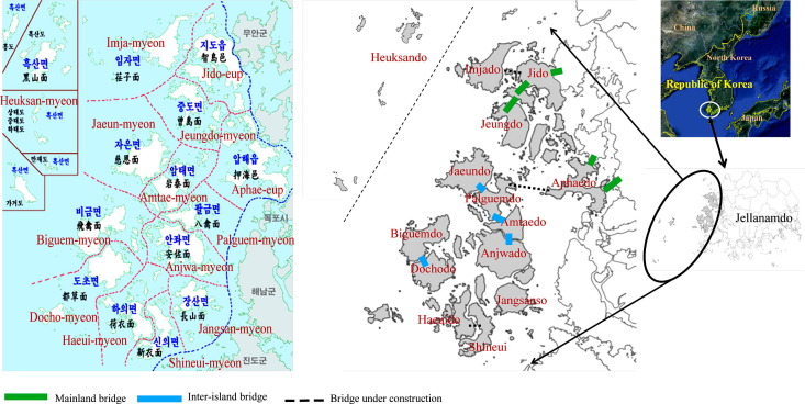
Study area
Shinan-gun (County) is a local government entity located in the southwestern area of Korea. It is unique in that the area under its control consists solely of islands (Fig. 1). Shinan County is composed of two eup (towns) and twelve myeon (townships), and includes about 1000 inhabited and uninhabited islands. With the notable exception of Heuksan-myeon situated at a relatively distant location from the Korean peninsula, the majority of the Shinan County’s islands feature broad tidal flats. This region’s well-developed tidal flats are well known as areas conducive to the collection of small octopus and the cultivation of laver. The average temperature over the past six years has been 13.5–14.5 °C; meanwhile, the average annual precipitation has been 960.5–1483.3 mm. However, the majority of such precipitation has occurred during the summer months of June–August (Shinangun, 2013).
Shinan County includes the largest tidal flat in Korea. Tidal flats have been reclaimed from the 1800 s and after the Korean War with very large areas to make agricultural fields. The main land use found on the islands in the area is agriculture (Kim, 2015, 2014).
Jido-eup in Shinan County was connected to Muan County in Jeonnam Province on February 25, 1975. Aphae-eup was connected to Mokpo City in 2008, and is physically no longer an island. In addition, Jeungdo-myeon was connected to Jido-eup on March 30, 2010, thus making it possible to access Jeongdo-myeon by road through Jido-eup. A mainland bridge connecting Aphae-eup to Amtae-myeon by 2018 is currently under construction. Once this comes to pass, over half of Shinan County will be connected to the mainland.
Methods
Analysis of landscape structure
Landscapes are akin to a bird looking down on the ground from the sky, and can therefore be used to explain the ecological processes, functions, and changes carried out within a certain space using landscape ecology (Forman, 1995). The landscape structure serving as the basis for the study of a specific space represents an important study method with which to explain the energy flow within a particular landscape and the relationship between the landscape elements. The characteristics of landscape structures can be saliently explained based on the introduction of land use as a landscape element. Land use patterns were analyzed to perceive the landscape structure, which in turn was analyzed using the landscape indices derived through the analysis of land use patterns.
A land use map was prepared during 2011–2012 by conducting a field survey and research based on the land use map published by the National Geography Institute in 2007. Landscape indices are one of the basic methods used to analyze landscape structures.
It is always necessary to take into account the ecologically relevant attributes when we want to use this approach for any landscape mosaic. These attributes express qualitative (land use type), and quantitative (size, number) characteristics of landscape elements or landscape as a whole (Turner et al., 2001; Sklenička and Lhota, 2002; Corry, 2005).
Spatial characteristics (i.e. pattern, diversity, heterogeneity, etc.) of the landscape spatial pattern were analyzed by FRAGSTATS of spatial statistics (McGarigal and Marks, 1995). In particular, spatial indices (i.e. size, number and patch density) for each land use type were adopted to understand the relationship between each patch type in the landscape mosaics (Table 1).
| Acronym | Metric | Explanation |
|---|---|---|
| Area metrics (Patch density, patch size and variability metrics) | Key aspect of landscape heterogeneity. If area metrics value increases it is understood fragmentation increases in the field. If area metrics value decreases it is understood fragmentation decreases in the field | |
| Area | Area of each patch (ha) | |
| TA | Total landscape area (ha) | |
| NP | Number of patch | |
| MPS | Mean patch size (ha) | |
| PSSD | Patch size standard deviation (ha) | |
| PSCV | Patch size coefficient of variation (%) | |
| Edge metrics | Amount of edge relative to the landscape area. It can be used to determine important areas for wild life especially who prefer to live in edge area for habitat | |
| TE | Total edge (m) | |
| ED | Edge density (m/ha) | |
| MPE | Mean patch edge (m) | |
| Shape metrics | Patch shape complexity. An index of human interference with landscape pattern. If this value approaches 1 it is simple patch shape and approaches 2 when shapes are more complex | |
| MSI | Mean shape index | |
| AWMSI | Area-weighted mean shape index | |
| MPFD | Mean patch fractal dimension | |
| AWMPFD | Area-weighted mean patch fractal dimension | |
| Diversity metrics | Patch distribution | |
| SHDI | Shannon’s diversity index | SHDI refers to diversity of patches in the area. If SDI value is zero it is understood area consist of single patch |
| SHEI | Shannon’s evenness index | SEI identifies to distribution (regular or irregular) of patches in the area. If SHEI value approaches 1 it is understood patches distribution are regular in the field |
The landscape indices Number of Patch (NP), Mean Patch Size (MPS), PSSD (Patch Size Standard Deviation) and Patch Size Coefficient of Variation (PSCV) in patch area metrics, the Mean Patch Edge (MPE), Edge Density (ED) and Total Edge (TE) in edge metrics, Mean Shape Index (MSI), Area-Weighted Mean Shape Index (AWMSI), Mean Patch Fractal Dimension (MPFD) and Area-Weighted Mean Patch Fractal Dimension (AWMPFD) in patch shape metrics, were applied to measure spatial pattern (McGarigal and Marks, 1995; Hietala-Koivu, 1999; Turner et al., 2001; Corry, 2005).
Area metrics were used as indicators of habitat fragmentation and habitat quality. It is a fundamental aspect of landscape structure. When the MPS of a patch type within a single landscape, is smaller than another patch type, it is considered more fragmented. NP, in the entire landscape mosaic, could serve as a good heterogeneity index because a landscape with greater patch density would have more spatial heterogeneity (McGarigal and Marks, 1995).
Edge metrics of a landscape are important to many ecological phenomena. In particular, a great deal of attention has been given to wildlife-edge relations. In landscape ecological investigations, much of the presumed importance of spatial pattern is related to edge effects. The forest edge effect, for example, results primarily from differences in wind and light intensity, and quality reaching a forest patch that alter microclimate and disturbance rates. These changes, combined with changes in seed dispersal and herbivory, can influence vegetation composition and structure.
Shape metrics are more suitable than MSI (Mean Shape Index) and MPFD (Mean Patch Fractal Dimension) when a few land use types are dominant in study areas (McGarigal and Marks, 1995). The complexity of patch shape was measured using AWMSI, which can be used to compare changes in the shape of landscape mosaics. AWMSI and AWMPFD are indices which show the patch shape by patch area and perimeter, and are usually used as indicators for wildlife habitats. They indicate that the patch shape is more natural, or in other words has more complicated boundaries, if the value is high (Turner et al., 2001; Moser et al., 2002). Diversity metrics explain about patches being more diverse or evenly distributed.
Cluster analysis
Cluster analysis revolves around the division of items into different groups based on the characteristics of the data analyzed. As it exhibits the characteristics between different groups, it has been widely hailed as one of the most useful analytical methods. Cluster analysis using various metrics for landscape indices has in particular been perceived as a useful method to analyze landscape structures (Szabó et al., 2008). As such, the characteristics of each island in Shinan County were studied based on the cluster analysis of the landscape structure developed in accordance with land use patterns.
Results
Landscape structure
Table 2 shows the results of landscape indices of each island. Aphaedo was found to be the biggest island in Shinan County, followed by Jido. However, Jido was found to be more fragmented than Aphaedo, with a higher number of patches found on the former. Heuksando exhibited the smallest number of patches, having less than half the number of patches found on the island of Hauido characterized by the smallest area. Furthermore, considering the mean patch size (MPS), Heuksando exhibits the biggest MPS of all the islands in Shinan County. This can be understood to mean that Heuksando not only has the biggest MPS in Shinan County, but also boasts non-fragmented patches.
| TA | NUMP | MPS | MEDPS | PSCOV | PSSD | TE | ED | MPE | MSI | AWMSI | MPFD | AWMPFD | SDI | SEI | |
|---|---|---|---|---|---|---|---|---|---|---|---|---|---|---|---|
| Docho | 5645.6 | 319 | 176977.44 | 20542.47 | 413.38 | 731588.03 | 781616.88 | 0.01 | 2450.21 | 1.96 | 3.51 | 1.37 | 1.34 | 1.60 | 0.58 |
| Bigeum | 6843.1 | 545 | 125561.04 | 17749.17 | 633.67 | 795644.30 | 1030179.60 | 0.02 | 1890.24 | 1.91 | 3.75 | 1.37 | 1.35 | 1.80 | 0.64 |
| Sineui | 4418.5 | 387 | 114172.15 | 13323.80 | 539.48 | 615936.53 | 590880.24 | 0.01 | 1526.82 | 1.75 | 3.20 | 1.37 | 1.33 | 1.47 | 0.52 |
| Anjwa | 8835.5 | 860 | 102739.20 | 12116.70 | 461.67 | 474320.01 | 1416575.82 | 0.02 | 1647.18 | 1.81 | 3.25 | 1.37 | 1.35 | 1.68 | 0.59 |
| Amtae | 6637.1 | 522 | 127147.08 | 13642.48 | 492.40 | 626077.74 | 875722.68 | 0.01 | 1677.63 | 1.91 | 2.82 | 1.38 | 1.32 | 1.48 | 0.54 |
| Aphae | 14357.6 | 1055 | 136090.89 | 14259.75 | 649.46 | 883849.38 | 1962663.16 | 0.01 | 1860.34 | 1.84 | 4.10 | 1.37 | 1.36 | 1.49 | 0.50 |
| Imja | 5888.5 | 403 | 146115.64 | 22247.93 | 328.23 | 479593.72 | 833406.36 | 0.01 | 2068.01 | 1.87 | 3.17 | 1.36 | 1.33 | 2.03 | 0.70 |
| Jaeun | 6203.9 | 518 | 119765.65 | 12687.38 | 420.62 | 503753.20 | 980185.45 | 0.02 | 1892.25 | 1.90 | 3.65 | 1.38 | 1.36 | 1.68 | 0.60 |
| Jangsan | 3527.6 | 430 | 82037.48 | 11001.78 | 441.19 | 361941.31 | 652502.97 | 0.02 | 1517.45 | 1.76 | 4.30 | 1.38 | 1.36 | 1.68 | 0.64 |
| Jeungdo | 6653.7 | 725 | 91775.52 | 9576.50 | 718.98 | 659848.62 | 998679.75 | 0.02 | 1377.49 | 1.86 | 3.23 | 1.38 | 1.34 | 1.44 | 0.55 |
| Jido | 12741.2 | 1206 | 105648.38 | 14015.15 | 611.69 | 646239.71 | 1959295.37 | 0.02 | 1624.62 | 1.85 | 3.14 | 1.37 | 1.34 | 1.69 | 0.58 |
| Palgeum | 2806.3 | 279 | 100584.26 | 14481.37 | 381.36 | 383584.66 | 449415.13 | 0.02 | 1610.81 | 1.78 | 2.99 | 1.36 | 1.34 | 1.56 | 0.63 |
| Haeui | 2482.9 | 371 | 66923.60 | 12870.96 | 345.46 | 231195.10 | 501322.78 | 0.02 | 1351.27 | 1.77 | 2.97 | 1.37 | 1.35 | 1.75 | 0.63 |
| Heuksan | 3344.0 | 161 | 207702.46 | 22802.13 | 371.73 | 772087.25 | 378561.43 | 0.01 | 2351.31 | 1.96 | 2.97 | 1.37 | 1.33 | 1.43 | 0.54 |
With regard to the edge metrics, islands with large areas such as Aphaedo and Jido exhibited high numbers in terms of total edge (TE). However, Docho boasted the highest mean patch edge (MPE). With regard to the shape metrics, Jangsando exhibited a high value in terms of area-weighted mean shape index (AWMSI) and Area-weighted mean patch fractal dimension (AWMPFD). Its patch shape was found to be more irregular and closer to the natural state than that of the other islands. With regard to the diversity metrics, Imjado was found to have various patches, with its patches being more uniformly arranged.
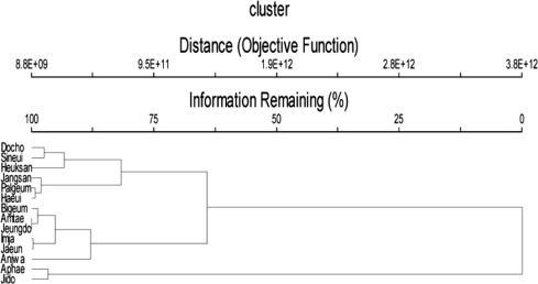
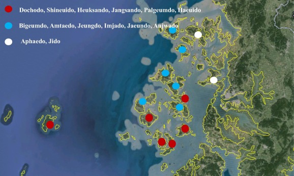
Cluster analysis
The characteristics of 14 areas whose land structure was analyzed based on land use were divided into three groups (Fig. 2). Group 1 includes Jido and Aphaedo connected to each other by a bridge. The other 12 islands were divided into Group 2 and Group 3. Group 2 consists of Bigeumdo, Amtaedo, Jeungdo, Imjado, Jaeundo, and Anjwado while Group 3 includes Dochodo, Shineuido, Heuksando, Jangsando, Palgeumdo, and Haeuido. The islands that make up Group 2 are located further north than those of Group 3.
Discussion
From a socioeconomic standpoint, islands are greatly influenced by events such as the influx and outflow of population and the industrial change that follows their connection to the mainland (Baldacchino, 2004, 2007a,b; Weiner, 1999). The scale of transportation naturally increases when the main transportation mechanism on the island changes from ships to automobiles. Increased flows of transportation in turn leads to an influx of population with various aims and goals. In the case of Korea, the emergence of islands as tourist destinations led large numbers of people to purchase land on such islands for investment purposes such as the construction of pensions and resorts. The easing of access and transportation as such had a direct correlation with the purchase of land for investment purposes (Tonkinson, 1997). This in turn greatly influenced land use, and eventually led to a change in land structure (Kim, 2014).
A look at the landscape structure of islands in Shinan County reveals that Aphaedo and Jido boast a larger numbers of patches. However, while being smaller in area than its counterpart, land use on Jido has occurred on a much denser scale, a denouement occasioned by its connection to the mainland earlier than Aphaedo. While Jido was connected to the mainland during the 1970s, Aphaedo was only connected to the mainland in 2008, or some 40 years later. Meanwhile, Heuksando featured fewer than half of the patches found on Hauido, which is smaller than Heuksando. In addition, the patches of Heuksando, which boasted the biggest MPS, were found to not be fragmented.
Heuksando is located in the western part of Shinan County, and is relatively farther afield than the other islands. A general lack of transportation has made access to Heuksando difficult. In addition, the lack of wide tidal flats in Heuksando, which does not have much farmland, has resulted in only limited amounts of reclaimed land (Kim, 2014). The mountainous terrain found on this island has rendered the island largely inhospitable to rice farming (Kim, 2015). With the exception of Heuksando, all of the other islands generally feature wide tidal flats; moreover, the presence of large-scale reclamation projects has meant that denizens have been engaged in rice farming since the late 18th century. While the main industry of these islands has traditionally been agriculture, the major industry on Heuksando has been fishing. As a result of these factors, Heuksando has been deemed relatively safer from physical disturbances caused by humans.
Based on the cluster analysis using landscape indices created through land use patterns, the islands of Shinan County were divided into three groups (Fig. 3). Both home to a bridge connecting them to the mainland and located relatively closer to the Korean peninsula, Jido and Aphaedo were included in Group 1. Because they were located closer to the mainland these two islands were in fact easier to access than the other islands even before the construction of bridges.
Having been connected to the mainland by a bridge in 1975, Jido now boasts very few differences from the mainland. As such, no unique island socio-cultural characteristics were uncovered. Aphaedo is the biggest island in Shinan County. It is connected to Mokpo City and the Shinan County Office was relocated from Mokpo to Aphaedo. The price of land on Aphaedo increased to several folds higher than that of land on the other islands during the relocation of the Shinan County Office. This phenomenon rapidly emerged when various development projects were carried out along with the relocation of Shinan County Office and the commencement of the construction of the New Millennium Bridge. These factors greatly influenced land use patterns and the landscape structure, and led to the emergence of a landscape structure that differed from that of the other islands.
Connected to the mainland via a bridge in 2010, Jeungdo is known as an island with a good ecological environment, a fact confirmed by its designation as a UNESCO Biosphere Reserve, Slow City, Tidal Flat Park of Jeollanamdo Province, and Wetland Reserve. Efforts to preserve the island via various methods have been hailed as having helped to provide the tools needed to protect the natural environment from the rapid development pressure and to maintain original land use types such as forests and beaches.
The other two groups were divided into islands referred to as upper islands (witseom) and lower islands (araetseom). The upper islands include Bigeumdo, Amtaedo, Imjado and Jeungdo, while the lower islands include Hauido and Shineuido close to Jindo. There is a tendency to regard the development of the lower islands as having been delayed by the lack of transportation. It was concluded that as the upper islands attracted more exchanges because of the ease of transportation, the culture of the upper islands was different from that of the lower islands. Because of their proximity to Jido to the north, the upper islands were in fact more closely connected to the mainland. As such, Groups 2 and 3 were divided based on various socioeconomic factors such as transportation issues and cultural differences.
Shinan County was the only one region whose administrative district was composed entirely of islands. However, the construction of mainland bridges connecting islands to the mainland has altered the land use of these islands. This phenomenon has also influenced the landscape structure. As land use is regarded as a barometer of socioeconomic characteristics, we can safely surmise that the construction of bridges has had an impact on the socioeconomic characteristics of these islands. These socioeconomic changes will eventually influence the cultural identity of islanders. While mainland bridges may be perceived as a necessary evil, more detailed and actual preparations and efforts will be needed to ascertain their impact on the residents of islands and to develop measures to counter such influences before the actual construction takes place.
Acknowledgement
This paper was supported by the National Research Foundation of Korea Grant funded by the Korean Government (MEST) (NRF-2009-361-A00007).
Endnotes
References
- Baldacchino, 2004 G. Baldacchino The impact of bridges and other fixed links on island communities: When small islans are connected to mainlands. ISLANDS of the WORLD VIII International Conference (2004), pp. 132-145
- Baldacchino, 2007a G. Baldacchino Fixed links and the engagement of islandness: reviewing the impact of the Confederation Bridge. Can. Geog., 51 (3) (2007), pp. 323-336
- Baldacchino, 2007b G. Baldacchino The bridge effect: a tentative score sheet for Prince Edward island in Bridging Islands. G. Baldacchino (Ed.), Brides & Islands: A Strained Relationship, Acorn Press, Charlottetown, PEI (2007), pp. 49-68
- Corry, 2005 R.C. Corry Characterizing fine-scale patterns of alternative agricultural landscapes with landscape pattern indices. Landscape Ecol., 20 (2005), pp. 591-608
- Forman, 1995 R.T.T. Forman Land Mosaics: The Ecology of Landscapes and Regions. Cambridge University Press, Cambridge (1995)
- Hietala-Koivu, 1999 R. Hietala-Koivu Agricultural landscape changes: a case study in Yläne, southwest Finland. Landscape Urban Plan, 46 (1999), pp. 103-108
- Karr, 1982 James.R. Karr Population variability and extinction in the avifauna of a tropical land bridge island. Ecol, 63 (6) (1982), pp. 1975-1978
- Kim, 2013 J.-E. Kim Land use management and cultural value of ecosystem services in Southwestern Korean islands. J. Mar. Isl. Cult., 2 (2013), pp. 49-55
- Kim, 2014 J.-E. Kim The value of ecosystem services on land use in Shinangun, Jeonnam, Korea. Korean J. Ecol. Environ., 47 (3) (2014), pp. 202-213
- Kim, 2015 J.-E. Kim Rural landscape and biocultural diversity in Shinan-gun Jeollanam-do. Korea. J. Ecol. Environ., 38 (2) (2015), pp. 249-256
- McGarigal and Marks, 1995 McGarigal, K., Marks, B.J., 1995. FRAGSTATS: Spatial Pattern Analysis Program for Quantifying Landscape Structure. Gen. Tech. Rep. PNW-GTR-351: U.S. department of Agriculture, Forest Service, Pacific Northwest Research Station, Portland, Oregon.
- Moser et al., 2002 D. Moser, H.G. Zechmeister, C. Plutzar, N. Sauberer, T. Wrbka, G. Grabherr Landscape patch shape complexity as an effective measure for plant species richness in rural landscapes. Landscape Ecol., 17 (2002), pp. 657-669
- Ryan, 2010 Erin Ryan Palazzolo, the public trust, and the property owner’s reasonable expectations: takings and the South Carolina marsh island bridge debate. South. Environm. Law J., 15 (2010), pp. 122-146
- Sklenička and Lhota, 2002 P. Sklenička, T. Lhota Landscape heterogeneity-a quantitative criterion for landscape reconstruction. Landscape Urban Plan., 58 (2002), pp. 147-156
- Szabó et al., 2008 S. Szabó, P. Csorba, K. Varga Landscape indices and land use – Tools for landscape management. Methods Landscape Res., 8 (2008), pp. 7-20
- Tonkinson, 1997 R. Tonkinson Anthropology and aboriginal tradition: the Hindmarsh Island bridge affair and the politics of interpretation. Oceania, 68 (1) (1997), pp. 1-26
- Turner et al., 2001 M.G. Turner, R.H. Gardner, R.V. O’Neill Landscape Ecology: Theory and Practice. Springer-Verlag, New York (2001)
- Weiner, 1999 James F. Weiner Culture in a sealed envelope: the concealment of Australian aboriginal heritage and tradition in the Hindmarsh Island Bridge affair. J. R. Anthropol. Inst., 5 (2) (1999), pp. 193-210