Geodiversity and geotourism utilization of islands: Gwanmae Island of South Korea
Earth Science Education, Chonnam National University, Gwangju, Republic of Korea
Earth Science Education, Chonnam National University, Gwangju, Republic of Korea yeongsanriver@daum.net
Earth Science Education, Chonnam National University, Gwangju, Republic of Korea
Science Education, Gwangju National University of Education, Gwangju, Republic of Korea
Abstract
The island area has well preserved geodiversity and biodiversity due to minimal exposure to humans. UNESCO has maintained things and sites with geological importance as geoheritage. Although a number of natural heritages and national parks exist on ‘geological’ bases, geodiversity concepts are less concerned about biodiversity due to a lack of recognition. Recently, geotourism linked to geodiversity has been activated in worldwide and geopark programs have been established in many countries. These precedents offer good chances for the use of geoheritage and preservation of geodiversity. Geopark programs can lead to the preservation of geodiversity and public geoeducation through tour of geosites. In particular, it is necessary to understand oceanic nature and culture including islands through geoeducation programs used by geodiversity of islands. Gwanmae Island is the first luxury village named by the Korea National Park Service. This study suggests plans of geotourism by geosites with noticeable geodiversity of the island.
Keywords
Island, Geodiversity, Geoheritage, Geotourism, Geosites, Geoeducation
Introduction
The core elements of World Heritage are composed of geodiversity and biodiversity. Geodiversity is the counterpart of biodiversity, composed of rocks, minerals, fossils, topographies and so forth. Of them, geological heritage sites that have to hand over to our descendants are called as sites of geoheritages (Lee, 2014).
Since the end of the 20th century, areal geology has been considered an important heritage, which contains the histories of lives and human evolution (Sohn, 2014). In addition, it has aroused sympathy that phenomena and sites with geological importance must be preserved as worldwide geoheritages for human beings (Brocx and Semeniuk, 2007). A number of world heritages and national parks are existed on geological bases, but geological meaning and importance of them are not fully recognized for the public. The viewpoint to geodiversity had to preserve do not approach as that to biodiversity (Carcavilla et al., 2009).
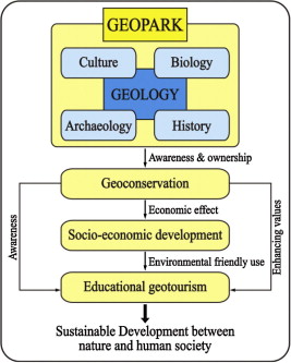
Recently, new chances for uses of geological heritages and the preservation of geodiversity are set up, as geotourism is motivated in worldwide and geopark programs settle in many countries. Particularly, geopark programs are evaluated valuably in viewpoints of the preservation of geodiversity by geotourism and geoeducational search (Dowling, 2011). The purpose of a geopark is development as sites of geologically valuable sites by connecting with other meaningful natural and cultural elements (UNESCO, 2014; Woo, 2014). Geoparks can improve the local economical benefits by areal geology and motivation of tourism through the preservation and educational visits to famous geosites (Fig. 1).
Many islands are distributed around the three coastlines of South Korea, a peninsular country. The island areas are good in geodiversity and biodiversity because of minimal exposure to humans. Korea National Park Service (KNPS) is establishing ‘National Park Luxury Village’ to restore natural ecology and to improve benefits of these falling behind areas through the supports to island and mountain ones. KNPS picked up Gwanmae Island as the first Luxury Village (Oh et al., 2012). This study considers using plans on geotourism and geoeducation by the investigation to geosites and geodiversity of Gwanmae Island.
Geosites and their uses
Internationally valuable areas in geology are designated as World Natural Heritage, and the value is called Outstanding Universal Value (Dingwall et al., 2005; Williams, 2008). Geosites mean valuable sites geologically. They include important geographical development stages of volcanic eruption, erosion and sedimentation in the history of the earth and geomorphological characters of volcanic and fault zones (Brocx and Semeniuk, 2007; Cowie and Wimbledon, 1994). On the other hand, geosites possess geologically important information of solid earth science, ore deposits, geological engineering, geomorphology, glacial geology, ground water, mineralogy, paleontology, petrology, sedimentology, speleology, stratigraphy, structural geology and volcanology.
Wimbledon et al. (2000) suggest the following qualifications of geosites:
- (1)
- The special, typical or unique features in space and/or time should be demonstrated in the proposal for a site.
- (2)
- The representativeness of a site in the geological column as a whole should be demonstrated.
- (3)
- A candidate should have an assessment within a named context (time/space), so that informed judgments and comparisons with other candidates can be made.
- (4)
- Sites with complex records, a long history of research, etc., are to be preferred as candidates (but new and unexploited sites should certainly not ruled out).
That is, geosites should have four elements: representativeness, suitability for correlation, comprehensive multidisciplinary study, and availability and potential. In addition, educational effects and approaches should be considered together in geosites because geosites are valuable in geotourism and improvement of local area, together with geological values.
Location and setting
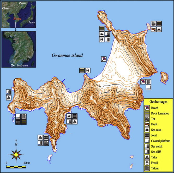
Jindo-Gun is composed of large and small inhabited/uninhabited islands. Gwanmae Island is located in the southwestern part of Jindo-gun. Many islands of the southwestern part of this area are suitable places of Archipelago National Park. Of them, Gwanmae Island, located in Jodo-myeon, has excellent diversity of geomorphology, geology and landscape (Fig. 2). The coastal area around the island is assigned to the submerged coast of ria type. It is reported that this type of coast in Korea was formed about 7000 years ago, in the Early Holocene (Jang et al., 1996). In the study area, tides are semidiurnal types showing diurnal inequality and are mid-tidal, measured about average 2 m of tide interval (Davies, 1964). The climate of the study area shows 14.2 °C in mean annual temperature, 1074.4 mm in mean annual precipitation and 1106.3 mm in mean annual evaporation. In the study area, winds are mostly northwesterly cold and dry ones in winter and southeasterly high temperature and humid ones in summer, respectively, representing 4.1 m/s of average annual speed. Storm days of above 13.9 m/s of wind speed average 22.9 days and concentrate in winter in the study area, and typhoons with above 17 m/s of wind speed mainly appear in summer. The typhoons pass around Mokpo city in the frequency of average 1.9 times/year (KMA, 2013). Geology around the study area is mainly composed of the Cretaceous volcanic and sedimentary rocks assigned to the Yucheon Group (KIGAM, 2002).
Geodiversity and geosites
Beach area
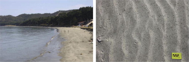
The beaches of Gwanmae Island exist along NNE-SSW direction, having an average width of 1.5 km, and show average intertidal zones of about 100 m due to tidal ranges. The sediments of 2–3 phi of mean size in the area are very well sorted. In the beaches, ripple marks from long shore currents develop along upper tidal zones, and ebbs around gravel in the beach make obstacle scours’ appearances in forms of ridges. The beach areas with 100 m in depth do not show suspended sand grains, displaying transparent emerald color, which equates to clean seas (Fig. 3).
Tors and sedimentary deposits
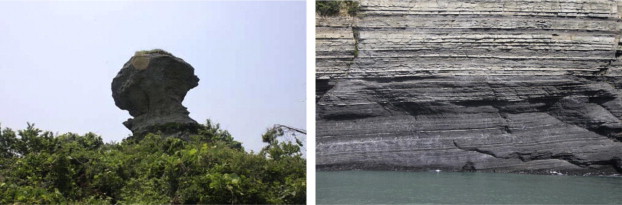
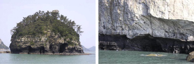
Bangyeo Island, forming a sea-stack in the northeastern part of Gwanmae Island, possesses a toloidal (bell shape) feature of 40 m height and 100 m length, elongated in NS direction. The island comprises sandstones and shales in the lower part and rhyolite tuffs in the upper part, indicating the Cretaceous period in geological age. Above deposits are about 10 m of shales, 15 m of sandstones and about 15 m of rhyolitic tuffs, respectively, and are observable in view because the deposits form cliffs. At the top of the island, tors of about 3 m diameter and 5 m height originated from areal weathering. The tors form a mushroom shape and are differentially weathered (Fig. 4).
Salt weathering
A stone tomb in the southern part of Gwanmae Island is located on the coastal platform with area of 40 m length and 50 m breadth. It forms a ridge type by salt weathering and represents 80 cm length, 70 cm breadth and 50 cm height in dimension, showing clear boundaries with about 1.5 m width. It consists of rhyolite tuff weathered differentially.
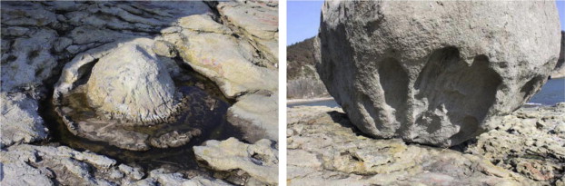
Ggongdol is a well-rounded elliptical boulder with a 6 m long axis and 4 m short axis. It develops finger shaped tafoni in base and a rounded surface due to weathering. Talus sediments are scattered around the Ggongdol. The Ggongdol itself is considered a talus product from near sea cliff. Probably, its tafoni and rounded shape are formed by a kind of differential weathering process (Fig. 5).
Sea cave and notch
In the southwestern part of Bangyeo Island, sea caves of 5–7 m height and 1–3 m width are linearly distributed in the above-mentioned shale beds. These caves are mostly developed in shale and tuff beds which are easily weathered. In addition, the southwestern part of Gwanmae Island, sea notches of about 2 m height, 1.5 m depth and 50 m length in dimension are well developed. The notches generally form through basal erosion of sea cliffs by active waves. They are concave bases eroded differentially, forming boundaries between shale and rhyolite tuff beds (Fig. 6).
Joints
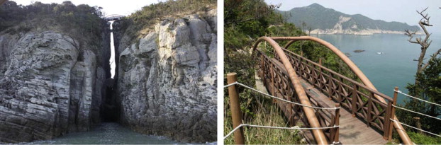
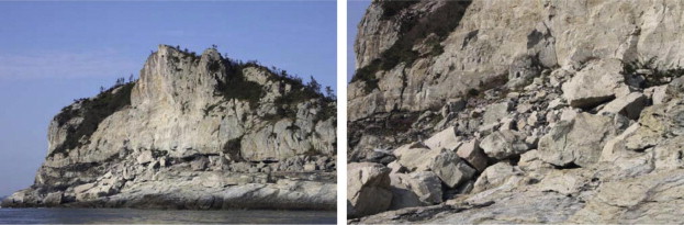
Gwanmae Island is divided into two parts by an E–W joint in the island. The joint interval is about 2–3 m and connected by a bridge (Haneul Bridge) over 50 m in elevation. The bridge is famous as a touring course. The interval surrounded by four faced sea cliffs has an incline of more than 80 degrees. Tors are topped on the cliffs. Falling rocks are scattered on the base, and perspective views on the bridge bring about feelings of the mystery of nature (Fig. 7).
Coastal platform
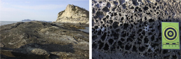
Coastal platform is developed in the western part of the island. The platform constitutes about 5 m elevation, 30 m width and 200 m length elongated along N–S direction. The platform is divided into three small rocky islands in high tide. It is used as a tour site in low tide. The platform has many tafoni formed by salt weathering (Fig. 8).
Sea cliff
In the western area of Gwanmae Island, sea cliffs develop nearly vertically. Strong wave action should produce the cliffs, and talus debris are scattered on their bases. Together with cliffs, wave action forms a coastal terrace, combining of sea level change. Sea notches and tafoni develop around the sea cliffs as well due to differential erosion (Fig. 9).
Uses and education of geotourism
It has been known that geotourism is similar to ecotourism, generally. However, at the same time, both are remarkably different. Ecotourism is to learn and to enjoy distribution and/or ecology of diverse plants and animals in specific area. Contrary to, above geotourism is to learn natural sequences and phenomena as forming process, formation of rocks and soils, flora and fauna and so forth, cultural development based on above natural environments, together with tour of above things. That is, geotourism is comprehensive of the whole range of ecotourism and extends to the uses of geological tour resources. However, manufacturing exhausts geologically useful areas, and geological education integrated to field works tends to reduce (van Loon, 2008).
Recently, touring tendency for valuable areas, geologically, is changing considerably. In the past, tourist groups tended to take pictures of landscapes and enjoy beautiful views. At present, however, tourism changes as patterns associated with viewing and enjoying, taking family touring. Patterns for educational touring can classify as three types as follows: (1) individual tour, (2) guided tours in which guides (natural heritage and geopark commentators) lead groups of 10–20 visitors, (3) group tours of over 30 visitors in their plans of study or travel management. Of these patterns, the guided tour is the most effective (Woo, 2014).
Geotourism is a method that can solve several problems related with educational tourism. It is necessary that individual and/or group visitors obtain knowledge in advance, getting a guide board and educational or informational image data. In addition, improvement of guide touring is important because the touring is most effective for education. Therefore, to nourish and to educate geotourism guides are very important. Guide tour program can carry out effectively educational touring. In particular, guide system using local dwellers could benefit locals through improved employment.
Conclusion
Natural environments with academic and heritable values have mostly been administrated nationally until geodiversity is importantly considered. However, the main players in reserving geological heritage are local societies and inhabitants themselves near the heritages. Actual economic benefits could improve through clean and ecological uses of geological heritages when local residents preserve the heritage with respectfully. That is, it is necessary to know that the preservation of geoheritages is closely related with the improvement of local economies.
In addition, geological heritage is also important for residential life and culture, not limited to the value only of geosites. The values of the heritages could increase when local residents recognize the economic improvements by the heritages. They could then carry out actual plans using them. International geopark experts indicate that inhabitants’ ownership of geoparks is the most important aspect. On the other hand, local inhabitants should take part in commentators of geoheritages and get benefits through development of memorial and unique goods using the heritages. For these purposes, it is necessary to make partnerships linked to educational institutions (elementary school to university, or research institutes in occasion), tour companies, restaurants and lodgings, non-governmental organizations, companies of unique goods and so forth, together with the construction of consistent master plans including the preservation and the administration of geoheritages. Geoheritages should be kept as important sites transferred to descendants, not a generation’s possession. Natural heritages are very important because they are not developmental subjects but preserving sites. It is expected that diverse plans to understand the cultures and the nature of islands and seas should be established through geoeducation programs using geodiversity of marine areas.
References
- Brocx and Semeniuk, 2007 M. Brocx, V. Semeniuk Geoheritage and geoconservation – history, definition, scope and scale. J. R. Soc. West. Aust., 90 (2007), pp. 53-87
- Carcavilla et al., 2009 L. Carcavilla, J.J. Durán, Á. García-Cortés, J. López-Martínez Geological heritage and geoconservation in Spain: past, present, and future. Geoheritage, 1 (2009), pp. 75-91
- Cowie and Wimbledon, 1994 J.W. Cowie, W.A.P. Wimbledon The world heritage list and its relevance to geology. D. O’Halloram, C. Green, M. Harley, M. Stanley, J. Knill (Eds.), Geological and Landscape Conservation, Geological Society, London (1994), pp. 71-73
- Davies, 1964 J.L. Davies A morphogenetic approach to world shorelines. Z. Geomorphol., 8 (1964), pp. 127-142
- Dingwall et al., 2005 P. Dingwall, T. Weighell, T. Badman Geological World Heritage: A global framework, A Contribution to the Global Theme Study of World Heritage Natural Sites. IUCN (2005). p. 51
- Dowling, 2011 R.K. Dowling Geotourism’s global growth. Geoheritage, 3 (2011), pp. 1-13
- Jang et al., 1996 J.H. Jang, Y.A. Park, S.J. Han Late quaternary stratigraphy and sea-level change in the tidal flat of Gomso bay, west coast of Korea. The sea. J. Korean Soc. Oceanogr., 1 (2) (1996), pp. 59-72. (in Korean with English abstract)
- KIGAM, 2002 KIGAM (Korea Institute of Geoscience and Mineral Resources), 2002. Explanatory Note of the Mokpo and Yeosu Sheets, Seoul, 45 (in Korean with English abstract).
- KMA, 2013 KMA (Korea Meteorological Administration), 2013. Annual Climatological Report, Seoul, 312 (in Korean).
- Lee, 2014 K.C. Lee Legal geoheritages: their values and meanings. J. Geol. Soc. Korea, 50 (1) (2014), pp. 165-191. (in Korean with English abstract)
- Oh et al., 2012 K.H. Oh, Y.K. Koh, S.T. Youn, H.G. Kim GGL (Geomorphology/Geology/Landscape) characteristics and geotourism utilization of Gwanmae eight landscape, Jindo, Jeonnam. J. Korean Isl., 24 (1) (2012), pp. 131-143. (in Korean with English abstract)
- Sohn, 2014 Y.K. Sohn Geoheritage in Korea and its conservation, utilization and management plans. J. Geol. Soc. Korea, 50 (1) (2014), pp. 1-2. (in Korean with English abstract)
- UNESCO, 2014 UNESCO, 2014. Available from: <http://www.unesco.org/new/en/natural-sciences/environment/earth-sciences/global-geoparks/> (March 10, 2014).
- van Loon, 2008 A.J. van Loon Geological education of the future. Earth Sci. Rev., 86 (2008), pp. 247-254
- Williams, 2008 P. Williams World Heritage Caves and Karst – A Thematic Study. IUCN World Heritage Studies no. 2. IUCN (2008). p. 57
- Wimbledon et al., 2000 W.A.P. Wimbledon, A.A. Ishchendo, N.P. Gerasimenko, L.O. Karis, V. Suominen, C.E. Johansson, C. Freden Geosites – an IUGS initiative: science supported by conservation. D. Barettino, W.A.P. Wimbledon, E. Gallego (Eds.), Geological Heritages: Its Conservation and Management, IGME, Madrid (2000), pp. 69-94
- Woo, 2014 K.S. Woo Qualification and prospect of national and global geoparks in Korea. J. Geol. Soc. Korea, 50 (1) (2014), pp. 3-19. (in Korean with English abstract)