The expansion of urbanisation in the Balearic Islands (1956–2006)
Department of Earth Sciences, University of the Balearic Islands, 07122 Palma, Illes Balears, Spain tpons@gaat.es
Department of Earth Sciences, University of the Balearic Islands, 07122 Palma, Illes Balears, Spain orullan@uib.es
Abstract
Since the mid-20th century the Balearic Islands have experienced significant changes as a result of their incorporation into the global economy as a mass tourism destination. The expansion of urbanisation has become a main change, given that the archipelago’s urbanised surface has increased fivefold since 1956. The territory of the islands has been organised internally to meet the demands of, first, tourism, and, second, the residential demands of Central European countries. The process has generated a whole new territorial model, dominated by new urban coastal and metropolitan areas in larger cities. This new model overlaps the regular traditional scattered centres inland with some walled coastal towns, from the pretourist model. This paper quantifies, describes, and explains these changes based on data from a series of land cover maps of 1956, 1973, 1995, and 2006, paying special attention to the particularities of each of the islands: Mallorca, Menorca, Ibiza and Formentera.
Keywords
Urban sprawl, Balearic Islands, Tourism, Coastal urbanisation
Introduction and objectives
As many authors have pointed out, both the expansion of urbanisation and the internal transformations of cities over the past 50 years are two sides of the same coin that reflect the significant socioeconomic changes experienced by the Western capitalist world since the end of World War II (Turner et al., 1990; Prud’homme and Lee, 1999; Catalán et al., 2008; Valera et al., 2007; Pons and Rullan, 2014; Arellano and Roca, 2010; Fulton et al., 2001; Galster et al., 2001).
The last big push of urban growth in the Western world is part of the dynamic that Arrighi (1994) defined as the “long twentieth century”, a cycle of accumulation articulated around the hegemony of the United States, a nation that ultimately has led neoliberalism (Harvey, 2005), the financial phase of this cycle. This last capitalist cycle, as the previous ones, generated a remarkable amount of surplus capital that absorbed, as stated by Harvey (2008), by the fixed capital of companies, government infrastructures, and the urbanisation and construction held by companies and individuals. This facilitated the necessary landing of accumulated capital to dissipate over time the recurring crises of capitalist overproduction.
This process has been clear and convincing in the United States, where suburbanisation after World War II has been its greatest exponent. In Europe, cities have traditionally been more compact than modern American cities. Nonetheless, the pace of growth and transformation was also accelerated during the second half of the 20th century through the adoption of a more extensive model than in previous eras (Arellano and Roca, 2012; Aguilera et al., 2011). Suburban trends, encouraged by powerful new communications and transport systems, have been affected all around.
The environmental, social, and economic consequences brought by this change are very important (European Environment Agency, 2006a). In urbanised areas, however, the overall figures, in percentage terms, are not that flashy, although the local concentration of these changes have had a significant global impact (Turner II and Butzer, 1995), considering that these are irreversible phenomena (European Environment Agency, 2003) with cumulative effects in the medium and the long term.
South Mediterranean Europe has participated in this expansion, especially its coasts, which have become surfaces suitable for building, with a faster growth rate compared with inland areas (European Environment Agency, 2006b), the encouragement of leisure activities in general and of tourism in particular being one of the most important causes of this development. The consequences are obvious: artificialisation, fragmentation of areas, loss of biodiversity and habitats.
Much like all major investments, the Mediterranean coastal urbanisation over the past 50 years would not have been possible without the transfer of capital from countries of Central and Mediterranean Europe derived from other economic activities. This has been called “capital switching” (Harvey, 1981, 1982), that is, the shift of capital from activities with decreasing profits to activities with better prospects. In the Mediterranean area, this investment generated what Gormsen described as a third coastal tourism periphery (Gormsen, 1997, p. 42).
The Balearic Islands (Fig. 1), which dominate the west of the western Mediterranean, constitute a good example of the expansion of urbanisation in the second half of the 20th century through the reinvestment of both local and foreign surplus capital. During the 1970s, Albert Quintana1 linked the industrialisation of Europe with the widespread urbanisation of Mallorca, the largest of the Balearic Islands, stating the following: “The area of our island is primarily organised according to the exploitation as an economic asset for the leisure of the industrial populations in Europe, and this production of recreational space is an asymmetric consequence of capitalist industrialisation. (…) The current urbanisation of Mallorca is the result of the industrialisation of the leading capitalist countries of Europe, the standard of living of which allows them to use the island as a recreational space, rearranged for this purpose” (Artigues et al., 2008, translated).
This paper will measure and analyse the urbanisation of the Balearic Islands since they joined the European tourism map in the mid-20th century.
The analysed period (1956–2006) corresponds to the expansive economic cycle that began in the second half of the Spanish 20th century with the first measures of economic liberalisation adopted by Franco’s dictatorship (López and Rodríguez, 2010). For the Balearic Islands, this period spans the incorporation of the Balearic economy into the global economy as a mass tourism destination until the beginning of the financial crisis of 2008. During this half century, the Balearic Islands experienced a radical economic transformation. Gross domestic product (GDP) increased from 1626 to 18,5272 million, 14,000 tourist accommodations became 423,259, and the 222,253 tourists that had visited the islands in 1956 added up to 12,526,600 in 2006 (Murray, 2012). Obviously, urban growth has not been alien to these macromagnitudes, and, as will be studied in this work, the 56 km2 of urbanised surface that covered the archipelago in 1956 became 310 km2 in 2006, and the artificial areas multiplied by 5.5.
In any case the neighbouring islands and the Balearics are no exception. Otherwise, the degree of coastal urbanisation is lower compared with other Mediterranean coastal regions. There are several explanatory factors that will be studied in another work (Pons and Rullan, 2014).
This process generated a whole new territorial model, dominated by new urbanized coasts and metropolitan areas in larger cities. This new model is what we want to measure and analyse.
Background
There are many works related to the evolution of the urbanisation of Spanish coastal areas, such as the Costa Brava (Emmi and Santigosa, 1989), the Valencia coast (Ezquerra et al., 1999; Martí and Nolasco, 2011), the Andalusian coast (Villar, 2011; Almeida and Cortés, 2011), and the Canarian coast (González and Sobral, 2011; Simancas et al., 2011). All these studies have been elaborated from photo interpretation and (or) remote sensing, the European project CORINE Land Cover3 (Feranec et al., 2007) being the main and most recent data supplier for these and other investigations.
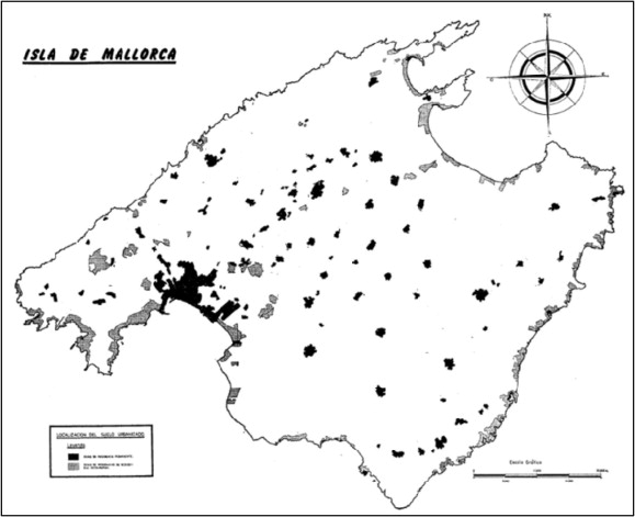
As for the Balearic Islands, the first urbanisation map included only the island of Mallorca in 1973. This was published in 1977 by the already mentioned Albert Quintana (Fig. 2). Elaborated with 1973 photography, it used a methodology that makes it very difficult to compare the outcome with the results of most recent maps. Anyway, the relevance of this map is based on the fact that it clearly drew the dual peopling between inland areas of permanent residence of the local population (except Palma, the capital) and new urban areas of residential and tourist coastal use.4 Urban growth was increasing.
All the same, beyond this pioneering work, the immediate antecedents of the current urbanisation maps of the archipelago are two projects funded by the Government of the Balearic Islands. One was elaborated within the framework of the drafting of the Regional Planning Guidelines,5 which included two land cover maps of 1973 and 1995. The other was funded by the government of the Balearic Islands tourism, incorporating the corresponding maps of 1956 and 2006. The data obtained from these two projects became the basis of subsequent works (Pons, 2003; Blàzquez et al., 2008). The data analysed in this paper are the result of another project currently funded by the Spanish government,6 which has improved and standardised the series of maps available for the set of the Balearic Islands from a larger methodological review.
Methodology
The corrected series of the works cited (1956, 1973, 1995, and 2006) comprise the entire economic cycle of the second half of the 20th century, coinciding with the different stages that have been defined for the Balearic case (Rullan, 1998).
The level of precision of the original maps made by photo interpretation is 1:25,000, depending on which a surface of 3 hectares has been set as the minimum mappable area for urban zones. As for the legend, it has been adapted to the nomenclature of categories of the Corine Land Cover project (Level 2) to allow comparison with other European scope studies.
Using this cartography, several diachronic analyses for each period were undertaken. Strips of 1 and 2 km from the coast were defined in order to study the shoreline in detail. These are commonly used strip widths for the study of these problems in other similar works (OSE, 2006).
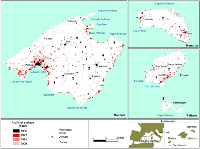
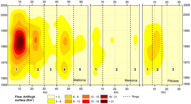
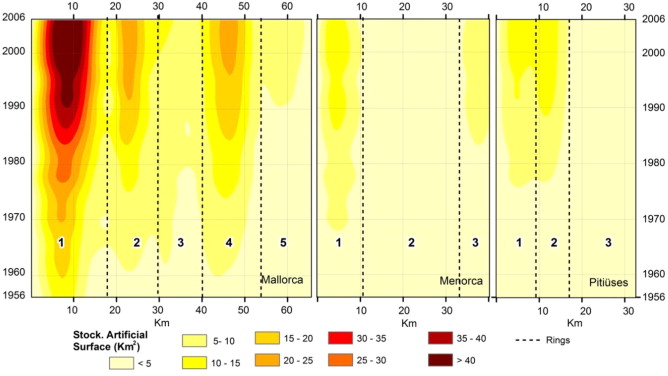
Moreover, a summary map of urban growth in the Balearic Islands (Fig. 1) and two summary charts (Figs. 3 and 4) were drawn, using the same methodology implemented to analyse the expansion of hotel accommodation (Pons et al., 2014). In these charts, inspired by those elaborated by Morrill (1970, p. 265), the Euclidean distance in abscissa stands to the main focus of tourism activity, the three insular airports, and the timescale in ordinate. The annual flow values of increased urbanised surface are represented by the model of spline interpolation.
Results
A first reading of the results reveals some relevant data (Table 1 and Figs. 1, 3 and 47).
| 1956 | 1973 | 1995 | 2006 | |||||
|---|---|---|---|---|---|---|---|---|
| km2 | % | km2 | % | km2 | % | km2 | % | |
| Balearic Islands | 56.27 | 1.13 | 125.35 | 2.52 | 270.65 | 5.44 | 309.85 | 6.23 |
| Mallorca | 48.58 | 1.34 | 95.42 | 2.63 | 199.48 | 5.50 | 231.38 | 6.38 |
| Menorca | 6.15 | 0.89 | 16.41 | 2.36 | 33.60 | 4.84 | 36.45 | 5.25 |
| Ibiza | 1.30 | 0.23 | 12.38 | 2.16 | 35.77 | 6.25 | 40.22 | 7.03 |
| Formentera | 0.24 | 0.29 | 1.02 | 1.23 | 1.81 | 2.20 | 1.82 | 2.20 |
First, despite the understandable superiority of Mallorca, the largest of the Balearic Islands, over the other islands in absolute terms and in all the analysed data, since 1995 Ibiza has overtaken, in relative terms, the rest of islands as for the percentage of area urbanisation. Second, there is the differentiation of the Bay of Palma (Mca1) from the rest of the archipelago (Fig. 1). However, in spite of the supremacy of Ibiza with regard to the already mentioned percentage of urbanisation, the Bay of Palma is much more urbanised than the island of Ibiza in absolute terms.
Third, it must be noted that Formentera, the smallest of the inhabited islands, which does not have an airport, presents a lesser degree of urbanisation from the rest, both in absolute and relative terms, far below the rest of islands.
Larger areas and connectedness to the outside world go hand in hand, as shown by the urbanisation data of each island.
In measuring and analysing exclusively the first kilometre from the shoreline, some differences emerge in the percentages regarding the urbanisation of the islands, calculated on the archipelago totals. Nonetheless, there has been a clear general slowdown in the process of coastal urbanisation since the second half of the 1990s (Fig. 5).
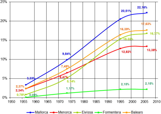
The urbanisation percentage of the first kilometre from the shoreline in 1956 was 0.09% in Formentera and 3.33% in Mallorca, whereas in 2006 the percentages were 2.18% and 22.16%, respectively. There have been no changes in the rankings concerning the most and the least urbanised islands, that is, Mallorca and Formentera, respectively. Certainly, this has not been the case of Menorca and Ibiza, because the latter surpassed the former during the 1980s. The tourist economy came earlier to Ibiza than to Menorca, along with urbanisation.
In terms of geohistorical analysis, it is interesting to observe the whole spatiotemporal chart of urban growth. In Fig. 3, the intersection between the spatial variable, represented by the distance to the airports, and the temporary variable displays a flow that draws the most heated areas and moments of urbanisation in the Balearic Islands.
On a first reading of the chart it can be observed that the most intense urbanisation moment in the Balearic Islands occurs in the late 1970s and the 1980s, coinciding with the years that preceded the full economic integration of Spain into the structures of the current European Union (1986), that is, coinciding with the gradual decline of barriers to capital movements.
Geographically, different areas are identified. In Mallorca, first and prominently, there is the metropolitan area of Palma (Mca1); second is the urban sprawl of Calvià beyond the Bay of Palma (Mca2); finally, the area between 42 and 52 km from the airport (Mca4) stands out, which corresponds to the bays of the northern and the southern coast of Llevant (the main tourist areas of Mallorca). In Menorca the steady urban sprawl of the metropolitan area around Maó (Men1) during the 1970s and the 1980s has to be mentioned, because the industrial tradition of the island was still alive in the 1970s when the tourism and residential offer was added in 1980. Regarding Ibiza and Formentera, the metropolitan area of the capital of the island centralises the greatest development (Pit1), although the tourist area of the Bay of Sant Antoni is also displayed (Pit2).
Let us take a look with more detail and a historical perspective at the territorial account that has led to the present-day urbanisation map of the Balearic Islands.
The pretourist territorial model (1956)
The degree of urbanisation of the Balearic Islands in 1956 can be observed in the map of Fig. 1. It is an appropriate date to analyse the territorial model prior to the arrival of mass tourism. It was a society that until that moment had based its economic foundation on the exportation of agricultural and industrial products. The new geopolitical role adopted by the archipelago as a consequence of the westernisation of Franco’s dictatorship during its second phase would change its territories.
Observing urbanisation in 1956, the following can be stated:
- Mallorca, the largest island and the best connected to the outside, presented a higher degree of urbanisation although with comparatively modest indicators: 48.58 km2, 1.34% of the island. The largest and the best communicated island was, and still is, the least isolated, and consequently, the most urbanised.
- On the other hand, Menorca, although not reaching 1% of urbanisation, displays results that, in any case, are superior to those of the Pityuses Islands (Ibiza and Formentera). The traditional model for concentrated housing of Mallorca and Menorca posed higher percentages of urbanisation compared with the scattered habitat of the Pityuses (Rullan, 2002).
Regarding coastal urbanisation (Fig. 5), Mallorca and Menorca, especially the former, display a higher percentage of artificialisation on the first kilometre from the shoreline. In Mallorca, tourism would expand from the capital and some small traditional coastal villages over the years. As for Menorca, urbanisation basically coincided with the conurbations of the two main cities of the island, the modern bourgeois eastern capital of Maó and the religious and traditional western capital of Ciutadella. Following the general pretourist model, the Pityuses display fairly low percentages of occupation with regard to coastal urbanisation.
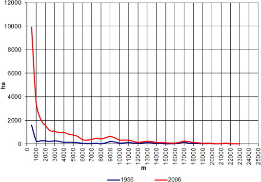
In the chart of Fig. 6, as for the whole of the Balearic Islands, the extensions of urbanisation in 1956 and 2006 are outlined, according to their distance to the coast. This chart highlights an important peak (9–10 km) that corresponds to a first line of traditional villages in Mallorca that were located at a reasonable distance to face the maritime danger that ravaged the island until the 18th century (Rullan, 2002).
Littoralisation of urbanisation (1956–1973)
Since the 1950s, the Spanish state left behind the economic autarchy that had characterised the beginning of Francoism (1939) and began a new phase of integration into the international capitalist economy (López and Rodríguez, 2010), encouraged by mass tourism, which was taking place in the Balearic Islands and much of the Mediterranean coast. Economic recovery after the Second World War and the generalisation of the welfare state contributed to the development of mass tourism in all Western economies.
The Balearic Islands also participated in this phenomenon, and, precisely, the development of European aviation would facilitate the fast growth of mass tourism. The Mediterranean coast of the Iberian Peninsula had already emerged as one of the main elitist tourism destinations in the early 20th century. The development of commercial aviation after World War II would finally approach the islands to the mainland. From the 1950s to 1973 tourism in the Balearic Islands would grow as well, with passengers arriving by plane, thus provoking the so-called first tourist boom (Murray, 2012; Rullan, 1998, 2002). The dictatorship opened the door to the investment of European capital, which was fresh foreign money accumulated during the 1950s and 1960s, thus aiding Franco’s dictatorship autarchic standstill.
One of the main consequences of the expansion of tourism was territorial transformation, which brought significant urban growth, especially on the coast. The littoralisation of urbanisation and the hotel industry are the most important manifestations of this period (Rullan, 2002). All islands experienced a noticeable increase in artificial surface (Table 1). The island-to-island analysis of this first growth reveals a direct correlation between the area of the islands and the percentage of urbanisation, from Mallorca to Formentera.
Data on coastal artificialisation (Fig. 5) confirm the importance of tourism as a key element in this process. Mallorca almost tripled the percentage of artificialisation of the first kilometre from the shoreline in this period: Ibiza increased to 6.5% (urbanisation percentages are much lower than the rest of islands) and Menorca to 2.75%. Ibiza, however, was still behind Menorca at this stage. In the whole of the Balearic Islands, 56.61% of new soil during this period was urbanised on the first kilometre from the shoreline (Mallorca 54%, Menorca 69%, Ibiza 53%, and Formentera 75%).
New urbanisation, linked to the expansion of tourism that was in force, concentrated around urban centres with outside connections. In Mallorca, the capital of the metropolitan area (Mca1 and Mca2 of Figs. 1 and 3) displays the biggest increase, although the northern and eastern coastal tourism areas (Mca4) have to be mentioned. In Menorca, new urbanisation is concentrated almost exclusively around the metropolitan area of Maó (Men1), strongly connected to residential uses and to a lesser extent, tourism (Marí, 2010). In Ibiza, new urbanisation is linked to tourist and residential growth in the capital (Pit1), but also to the major tourist centre of Sant Antoni (Pit2). Formentera developed around the port town of La Savina, the gateway for tourism to the island.
Consolidation of the process of littoralisation, metropolisation, and inland urbanisation (1973–1995)
In the early 1970s, Spain was experiencing the first real estate boom. It had been preceded by 15 years of fast urbanisation (López and Rodríguez, 2010), a process truncated by the oil crises of 1973 and 1979. Towards the mid-1980s, the growth supported by the new neoliberal policies began to confirm a new period of economic financial and real-estate expansion, something that would be repeated between 1996 and 2008. The upturn of the economic cycle also coincided with the entry of Spain into the European Community, entailing liberalisation and massive foreign investment (López and Rodríguez, 2010).
Despite the economic downturns of the 1970s, the urbanisation process in the islands continued despite some ups and downs during the 1973–1995 period. In the 1980s, the combination of both the tendency of the early 1970s, which still enshrined urban planning, and the economic boom were enough to maintain a high degree of urbanisation and construction (Rullan, 1999, 2010). Moreover, there was a turnaround from the intensive model of hotels and multi-family housing units to a more extensive urban model in which apartments and single-family homes spread all over. This expansion of the offer and demand implied a higher growth of the artificialised surface.
In the whole of the Balearic Islands, the urbanised surface (Table 1) multiplied by more than 2 during this period, reaching 5.44% in 1995. Comparatively, Ibiza experienced a higher growth of urbanisation in relative terms, reaching 6.25% of the island and tripling the coastline (Fig. 5), thus surpassing both the whole archipelago as each one of the rest of islands. In absolute terms of urbanisation, this is also the period when Ibiza (36 km2) surpassed Menorca (34 km2). The myth that Ibiza had been forged in the early 1960s hatched 20 years later as a highly urbanised hedonistic destination.
This was also a period of inward urban growth directly or indirectly related to coastal activity: urbanisations that were a result of income generated by shoreline businesses, working-class families buying second homes, service estates supplying tourist and construction activities, demands that had been assumed by the already urbanised areas in the previous period but which were depleted the new wave of demands of supply.
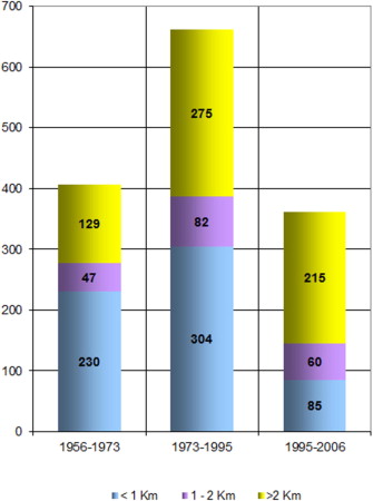
Fig. 7 shows comparatively how the urbanisation process of this second period is higher than the other two studied in this paper.
In the urban area of Palma urbanisation spreads along the highways that articulate it: the west one toward Calvià, the south one toward the airport, and the highway of Inca that goes inwards (Fig. 1). Indeed, the towns of Palma and Marratxí, linked by the Inca highway, concentrated in the period 55.5% of the total growth of new artificial soil beyond the first kilometre from the shoreline. In particular, this second period of growth is the moment of emergence of large isolated residential areas attached to the outskirts of Palma (Mca1, Fig. 3).
Besides, this would be the period of consolidation of the urbanisation in two areas that were already prominent in the previous phase: on the one hand, the municipalities of Andratx and Calvià (Mca2) that extend the metropolitan area of Palma westwards through the Ponent highway, opened in 1976; on the other hand, tourist areas of the northern and eastern coasts (Mca4) that hatched after the beginning of the urbanisation in the previous period. Due to their rugged relief, areas such as the Serres de Tramuntana or Llevant, as well as the Cap de ses Salines, Cap Blanc, Es Trenc, and the Cap of Cala Figuera, were left out of this process, because they did not have institutional and socioeconomic support to encourage their urbanisation.
In Menorca, the process of artificialisation of this period takes place on the coastline and the surroundings of the metropolitan area of Maó (Men1), although Ciutadella, on the other corner of the island, starts to stand out (Fig. 3). Referring to both the coast (Fig. 5) and insular totals (Table 1), as aforementioned, Ibiza surpassed Menorca during this period with regard to the degree of urbanisation in absolute and relative terms. The tourist success of Ibiza generated more urbanisation than in Menorca, which up to that point surpassed Ibiza because of its distinguishing trading and industrial tradition.
In Ibiza the urbanised land cover is concentrated mainly around the capital’s metropolitan area (Pit1) and especially in the Bay of Sant Antoni (Pit2), whereas urban growth in Formentera expands to other areas of the island beyond the port of La Savina, such as es Pujols. Nonetheless, the numbers of Formentera are still lower compared with the rest of islands due to its double insularity, as it is the only Spanish inhabited island that has no airport.
This period surpasses the previous one globally, comparing the 69 km2 of increasing urbanisation that occurred between 1956 and 1973 with the 145 km2 between 1973 and 1995 (Table 1). Therefore, as it can be seen, this second liberalising round of relationships and economic activities carried out in the 1980s had much more impact on urbanisation than the first one, which had followed the post autarchic dismantlement of Franco’s dictatorship with Western capitalist countries.
The slowdown of urbanisation especially on the coast (1995–2006)
Since 1992 the Spanish economy had shown stagnation signs, and in 1993, after the costs related to the Olympic Games and the Expo celebrated in 1992, GDP decreased by 1%. To overcome the crisis, the Spanish economic strategy was a new property cycle, in this case much longer than the one that occurred during the late 1980s (López and Rodríguez, 2010). This strategy was fully inserted into the globalised neoliberal logic that led to the crash of 2008.
In this new expansion phase of both national and international economy, the Balearic Islands also resumed the path of growth, focusing on construction instead of urbanisation, which stands out as a differentiating factor. The 1980s had seen the concentration of Balearic hotel companies in hotel chains, which were tourist transnational companies that had begun to expand beyond the Balearic Islands. Coinciding with this expansion, national institutional politics triggered containment policies, sharing some tacit agreement with environmental movements though conditioned by the interests of the hotel elites. These policies blocked the construction of new hotel facilities that did not meet with the 30 m2 land area per space parameter (1984) that, three years later (1987), increased to 60 m2 (Amer, 2006, pp. 96–102). In 1995, an urban and tourist plan preventing new forecasts of growth on the coast (Rullan, 1999, pp. 426–428) was approved and, since 1999, all the new residential areas should be a continuation of already existing ones and could not experience a surface growth higher than 10–12% (Rullan, 1999, pp. 435–437; Pons et al., 2014).
This institutional framework joined the handicap that insularity constitutes for foreign investment (Pons and Rullan, 2014). Capital accumulated in the previous period was not invested in hotel infrastructures in the Balearics but in distant destinations such as the Caribbean (Buades, 2006). This third growth boom would base mainly on property and residential, rather than on tourism and urbanisation, consolidating already urbanised areas in previous phases.
Fig. 8 outlines the property boom that occurred during the second half of the 1990s in each of the islands. Comparing Fig. 8 (new homes) with Fig. 8 (new urbanisation), it is clear that in the Balearic Islands this last stage previous to the 2008 crisis focused on already urbanised real estate land rather than on new hotel or urbanised surface.
As mentioned above, the 1995–2006 period brought an urbanisation slowdown, especially on the coast. From 1995 to 2006, land artificialisation adds up to only 39 km2, a poor number compared with the 69 km2 of the 1956–1973 period or the 145 km2 recorded between 1973 and 1995 (Table 1). Fig. 7 also reflects the decline, displaying 661 new urbanised ha/year in the 1973–1995 period and 360 hectares between 1995 and 2006. This decrease is even more important on the first kilometre from the shoreline, where the rate of urbanisation of 304 ha/year from the 1973–1995 period became 85 ha/year between 1995 and 2006. In this last period there is a paralysation of the urbanisation process in the islands in general and on the coast in particular with respect to the first two stages. The Balearic hotel elites now concentrate their investment activities especially in Central America and the Caribbean.
Conclusions
Since the Balearic Islands were introduced to the international tourist circuits in the mid-1950s, the archipelago has increased its urbanised surface fivefold. Until the 1990s, the increase was especially prominent on the coast, where on the first kilometre from the shoreline the urbanised surface multiplied by 7.4, increasing from 2.37% of the coastal strip in 1956 to 17.63% in 2006.
Until the 1990s, the urbanisation process in the islands in general and particularly on the coast maintained a fast pace. Nevertheless, coinciding with the last phase of neoliberal growth, urban growth paradoxically slowed down, so the last boom in economic growth (1992–2008) was defined by residential construction rather than by new urbanisation. The causes of this standstill are diverse and are related, on the one hand, to the introduction of measures to curb the spread of both hotels and urbanisation, and on the other hand, to the higher costs of urbanisation deriving from insularity that have to be faced, especially by non-insular companies. The construction of houses, however, increased at rates comparable with the rest of Spain, since the important urbanisation of earlier stages left a great deal of non-constructed urbanised land that had been clogging during the last decades.
The general process of urbanisation consolidated a new regional model, as previously described by many authors, characterised by some coastal areas overtaking the prominence of inland small towns. In this study this change has been quantified: in 2006, 43% of urbanised lands in the Balearic Islands were on the first kilometre from the shoreline, and this percentage reached 55.3% on the second kilometre. In 1956 these percentages were 32.3% and 42.1%, respectively.
As it can be seen in Figs. 4 and 6, the most remarkable growth of urbanisation between 1956 and 2006 occurred on the coast, although the inland urbanisation peaks that characterised the regional pretourist model are still noticeable. The traditional inland villages of Mallorca and Menorca have not disappeared. In fact, their areas increased, but the significant coastal growth lessened their relevance.
An analysis of the urbanisation at an insular scale (Fig. 1) shows that the biggest islands set the areas of influence of the main cities: Palma, Ibiza, Maó, and Ciutadella. These areas have higher levels of urbanisation peaks compared with the peaks that correspond to the traditional inland small towns.
Therefore, on the one hand, the models dominated by coastal urbanisation and, on the other hand, those by the spread of metropolitan areas of the main insular capitals have been consolidated.
Despite the growth experienced by the Balearic Islands in the period studied, the degree of their coastal artificialisation is still at the tail end compared with other regions in the same area, as discussed in another study (Pons and Rullan, 2014). Insularity and territorial plans promoted in the archipelago contributed to slowing down the process of urbanisation during the 1996–2006 period.
Finally, after more than 60 years of residential and tourism activity in the Balearic Islands, the accumulated stock of urbanisation is reflected in the map and chart from Figs. 1 and 4. The bulk of urbanisation is found in Mallorca, the largest and best connected island. It displays three main peaks: first and prominently, the first metropolitan area in Palma (Mca1), followed by the second peak of Palma (Mca2), and, finally, the northern and eastern tourist areas (Mca4).
The urbanised areas in the other islands are far from the magnitudes of urbanisation in Mallorca. Whereas in Menorca the area of influence of the former capital of the island (Ciutadella, Men3) begins to compete with the modern insular capital (Maó, Men1), in Ibiza urbanisation around the capital (Pit1) and the main tourist area of the island (Sant Antoni, Pit2) are practically balanced.
The size of the islands and their connections to the outside world explain the different degrees of urbanisation that can be found. It is a process of urbanisation that, compared with other Mediterranean tourist areas, has slowed down in recent decades. This is correlated with the Balearic hotel chains’ investment strategies outside the archipelago, which had coincided with the measures to limit the increase of the tourist offer and the urbanisation of the islands. The costs of insularity for investment, the institutional framework established in the 1990s, and the investing possibilities of the various local and foreign economic agents explain, therefore, the particular geography and the intensity of urbanisation of the Balearic Islands of the first decade of the 21st century.
Acknowledgments
The research on which this article is based is carried out within the project “Geographies of the Crisis: an analysis of the urban-tourist spaces of the Balearic Islands, Costa del Sol and the most important tourist destinations of the Caribbean and Central America” (CSO2012-30840) funded by the Spanish Ministry for Science and Innovation (National Plan for R+D+i).
Endnotes
References
- Aguilera et al., 2011 F. Aguilera, L. Valenzuela, A. Botequilha-Leitao Landscape metrics in the analysis of urban land use patterns: a case study in a Spanish metropolitan area. Landscape Urban Plan., 99 (2011), pp. 226-238
- Almeida and Cortés, 2011 Almeida, F., Cortés, R., 2011. Transformaciones urbanísticas y territoriales en la Costa del Sol Oriental ¿Otra Costa del Sol Occidental? In: Urbanismo expansivo de la utopía a la realidad, Universidad de Alicante, pp. 15–28.
- Amer, 2006 J. Amer Turisme i política. L’empresariat hoteler de Mallorca. Documenta Balear, Palma (2006)
- Arellano and Roca, 2010 B. Arellano, J. Roca El urban sprawl, ¿un fenómeno de alcance planetario? Los ejemplos de México y España. ACE: Arch. City Environ., 4 (12) (2010), pp. 115-148
- Arellano and Roca, 2012 B. Arellano, J. Roca Sprawl en las metrópolis europeas: las periferias metropolitanas, ¿principal escenario de la dispersión de la urbanización en Europa?. ACE Arch. City Environ., 7 (20) (2012), pp. 95-114
- Arrighi, 1994 Arrighi, G., 1994. The long twentieth century. Money, Power and the Origins of Our Times, London/New York: Verso.
- Artigues et al., 2008 Artigues, A.A., Blázquez, M., Gual, J., Mateu, J., Murray, I., Rullan, O. (Eds.), 2008. Albert Quintana: el seu temps i la seva obra, Govern de les Illes Balears, Palma.
- Bisson, 1977 J. Bisson La terre et l’’homme aux îles Baléares. Aix-en-Provence, EDISUD (1977)
- Blàzquez et al., 2008 Blàzquez, M., Murray, I., Pons, A., 2008. La explosión turística en las Islas Baleares (1956–2000). Cambios de usos del suelo y metabolismo socioeconómico. In: El paisaje en perspectiva histórica: formación y transformación del paisaje en el mundo mediterráneo, Universidad de Zaragoza, Zaragoza, pp. 351–375.
- Buades, 2006 J. Buades Exportando paraísos. La colonización turística del planeta. La Lucerna, Palma (2006)
- Catalán et al., 2008 B. Catalán, D. Saurí, P. Serra Urban sprawl in the Mediterranean? Patterns of growth and change in the Barcelona Metropolitan Region 1993–2000. Landscape Urban Plann, 85 (2008), pp. 174-184
- Emmi and Santigosa, 1989 P.C. Emmi, M. Santigosa Urban development land use planning and political change. The case of Costa Brava, Spain. Land Use Policy (1989), pp. 103-120
- European Environment Agency, 2003 European Environment Agency Plan Bleu and Centre d’Activities Regionales. EEA, Copenhagen (2003)
- European Environment Agency, 2006a European Environment Agency The Changing Faces of Europe’s Coastal Areas. EEA, Copenhagen (2006)
- European Environment Agency, 2006b European Environment Agency Urban Sprawl in Europe. The Ignored Challenge. EEA, Copenhagen (2006)
- Ezquerra et al., 1999 Ezquerra, A., Moreno, E., Otero, I., Urbano, J., 1999. Evaluación de cambios de cobertura del suelo en la Costa Valenciana 1975–1991. In: Rodenas (Ed.), VIII Congreso Nacional de Teledetección, Albacete: Santiago Castaño Fernández y Antonio Quintanilla, pp. 15–18
- Feranec et al., 2007 J. Feranec, G. Hazeu, S. Christensen, G. Jaffrain Corine land cover change detection in Europe (case studies of the Netherlands and Slovakia). Land Use Policy, 24 (2007), pp. 234-247
- Fulton et al., 2001 Fulton, W., Pendall, R., Nguyen, M., Harrison, A., 2001. Who sprawls most? How growth patterns differ across the U.S. Center on Urban & Metropolitan Policy, July 2001, The Brookings Institution, Survey Series.
- Galster et al., 2001 G. Galster, R. Hanson, M.R. Ratcliffe, H. Wolman, S. Coleman, J. Freihage Wrestling sprawl to the ground: defining and measuring an elusive concept. Housing Policy Debate, 12 (4) (2001), pp. 681-717
- González and Sobral, 2011 González, A., Sobral, S., 2011. El desarrollo urbano-turístico del municipio de Yaiza, Lanzarote: un ejemplo de crecimiento expansivo. In: Vicente Gonzálvez Pérez, Juan Antonio Marco Molina (Eds.), Urbanismo expansivo de la utopía a la realidad, Universidad de Alicante, pp. 319–330
- Gormsen, 1997 E. Gormsen The impact of tourism on coastal areas. GeoJournal, 42 (1997), pp. 39-54
- Harvey, 1981 D. Harvey Spaces of Capital: Towards a Critical Geography (2001). Routledge, New York (1981)
- Harvey, 1982 D. Harvey The Limits to Capital. Blackwell, Oxford (1982)
- Harvey, 2005 D. Harvey A Brief History of Neoliberalism. Oxford University Press, Oxford (2005)
- Harvey, 2008 Harvey, D., 2008. The right to the city. New Left Review, No. 53, pp. 23–40.
- López and Rodríguez, 2010 López, I., Rodríguez, E., 2010. Fin de ciclo. Financiarización, territorio y sociedad de propietarios en la onda larga del capitalismo hispano, Traficantes de Sueños, Madrid.
- Marí, 2010 Marí, S., 2010. El retard virtuós de Menorca. In Homenatge a Bartomeu Barceló i Pons, geògraf, Editorial Lleonard Muntaner, Palma, pp. 613–620.
- Martí and Nolasco, 2011 Martí, P., Nolasco, A., 2011. La expansión urbanística reciente de la costa alicantina, una realidad constatable. In Vicente Gonzálvez Pérez, Juan Antonio Marco Molina (Eds.), Urbanismo expansivo de la utopía a la realidad, Universidad de Alicante, pp. 367–378.
- Morrill, 1970 R.L. Morrill The shape of diffusion in space and time. Econ. Geogr., 46 (1970), pp. 259-268
- Murray, 2012 Murray, I., 2012. Geografies del capitalisme balear. Poder, metabolisme socioeconòmic i petjada ecològica d’una superpotència turística [Geographies of the Balearics’ capitalism. Power, socioeconomic metabolism and ecological footprint of a touristic superpower] (Ph.D. thesis), Universitat de les Illes Balears, Palma.
- OSE, 2006 OSE, 2006. Observatorio de la Sostenibilidad en España. Cambios de ocupación del suelo en España: implicaciones para la sostenibilidad, Mundi Prensa, Madrid.
- Pons, 2003 A. Pons Evolució dels usos del sòl a les Illes Balears. 1956–2000. Territories, 4 (2003), pp. 129-145
- Pons and Rullan, 2014 A. Pons, O. Rullan Artificialization and islandness on the Spanish tourist coast. Miscel. Geogr. Reg. Stud. Dev., 18 (1) (2014), pp. 5-16
- Pons et al., 2014 A. Pons, O. Rullan, I. Murray From three islands with cities to three tourist-city islands. Tourist accommodation diffusion in the Balearics (1936–2010). Island Stud. J., 9 (2) (2014), pp. 239-258
- Prud’homme and Lee, 1999 R. Prud’homme, C. Lee Size, sprawl, speed and the efficiency of cities. Urban Stud. (1999), pp. 1849-1858
- Rullan, 1998 Rullan, O., 1998. De la cova de Canet al tercer boom turístic. In: El medi ambient a les Illes Balears. Qui és qui? Caixa de Balears, Palma, pp. 171–213.
- Rullan, 1999 O. Rullan Crecimiento y política territorial en las Islas Baleares (1955–2000). Estudios Geográficos (1999), pp. 403-442
- Rullan, 2002 O. Rullan La construcció territorial de Mallorca. Editorial Moll, Palma (2002)
- Rullan, 2010 O. Rullan Las políticas territoriales en las Islas Baleares. Cuadernos Geográficos, 47 (2010), pp. 403-428
- Simancas et al., 2011 Simancas, M., García, J., Dorta, A., Falero, R., 2011. El impacto territorial de la moratoria turística de Canarias. In: Vicente Gonzálvez Pérez, Juan Antonio Marco Molina (Eds.), Urbanismo expansivo de la utopia a la realidad, Universidad de Alicante, pp. 715–726.
- Turner II and Butzer, 1995 Turner II, B.L., Butzer, K.W., 1995. The Columbian Encounter and environmental change. In: Global Land Use Change. A perspective from the Columbian Encounter, Consejo Superior de Investigaciones Científicas, Madrid, pp. 1–25.
- Turner et al., 1990 B. Turner, W. Clark, R. Kates, J. Richards, J. Mathews, W. Meyer The Earth as Transformed by Human Action: Global and Regional Changes in the Biosphere Over the Past 300 years. Cambridge University Press, Cambridge (1990)
- Valera et al., 2007 A. Valera, C. Añó, J. Sánchez Crecimiento urbano (1956–1998) en el entorno metropolitano de Alacant – Elx (Comunidad Valenciana). Boletín de la Asociación de Geógrafos Españoles, 44 (2007), pp. 169-186
- Villar, 2011 Villar, A., 2011. Territorio, turismo y paisaje: el proceso de urbanización en el litoral de Andalucía. El papel de los campos de golf. (Ph.D. thesis), Universidad de Sevilla, Sevilla.