Mangrove zonation and utilization by the local people in Ajuy and Pedada Bays, Panay Island, Philippines
School of Environmental Science and Management, University of the Philippines Los Banos, College, Laguna, Philippines
MC 24 Unit 304, Pamayanang Diego Silang, BCDA, Ususan, Taguig City, Philippines
Institute of Biological Sciences, College of Arts and Sciences/School of Environmental Science and Management, University of the Philippines Los Banos, College, Laguna, Philippines
Faculty of Management and Development Studies, University of the Philippines Open University, Philippines
iebuotjr@upou.edu.ph
Abstract
The study was conducted in order to establish and describe the mangrove zones and the resource uses in Ajuy and Pedada Bays, Panay Island, Iloilo, Philippines. Plot or quadrat method coupled with informal community folk interviews were done. Cluster and principal component analyses indicated four mangrove zones: Zone 1 – Avicennia–Sonneratia zone; Zone 2 – Avicennia–Rhizophora zone; Zone 3 – Avicennia–Excoecaria–Bruguiera–Ceriops zone; and Zone 4 – Avicennia zone. Fishpond establishment was the main dominant activity. Additionally, subsistent and apparently sustainable localized fuel wood gathering was still evidently practiced by the fisherfolks. With the bays’ natural mangrove landscape greatly deformed and transformed, the study recommends two strategies which could serve as its turning point leading to a more sustainable utilization and conservation of the mangroves. First we recommend the creation of a landscape corridor and secondly, adoption of a mangrove aquasilviculture system as an alternative to the current extensive fishpond practice. Implementation of these two strategies can be facilitated by a strong biodiversity education program and a local ordinance.
Keywords
Ajuy Bay, Fishpond, Panay Island, Mangrove utilization, Mangrove zonation, Pedada Bay, Philippines
Introduction
The mangrove ecosystem is a unique type of forest characterized by its highly specialized vegetation and a typical and limiting environment (Walsh, 1974). The distribution of individuals within it, as well as factors which have molded this habitat have become a recurrent concern in studies on mangrove ecology. Vegetation zonation of the mangroves, a frequently conspicuous feature, has long attracted scientific interest (e.g., see reviews by Walsh (1974), Snedaker (1982), Tomlinson (1986) and Hutchings and Saenger (1987), (Bunt et al., 1991). Incidentally, the zonation of mangrove ecosystems in Ajuy and Pedada, Iloilo, considered as vital areas in the province’s remaining stretch of mangrove belt is poorly known.
This paper examined the mangrove zones occurring in Ajuy and Pedada bays and recorded current utilization of the mangroves.
Methodology
Study area
The bays of Ajuy and Pedada are located in the coastal municipality of Ajuy (11°10’30’’ N, 123°1’16’’ E) in the northeastern part of Iloilo, a province in Panay Island, Philippines. Ajuy Bay borders the municipality of Ajuy in the south while Pedada Bay is situated further down, adjacent to the municipality of Barotac Viejo which borders Ajuy on the west. This municipality has a total land area of 17,557.19 ha and has a shoreline length which stretches to an estimated 74.83 km. As of 2007, the mangrove area in the municipality was reported to occupy 117.7 ha (Ajuy Municipal Agriculture Office, 2007).
Methods
Field method
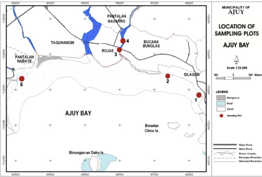
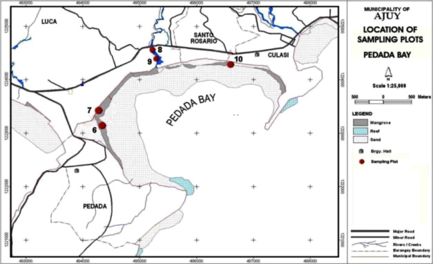
Ten sampling plots (20 × 20 m) were established randomly on the seaward and inland mangrove portions of the two bays. Plots 1–5 were located in Ajuy Bay (Fig. 1) and with plots 6–10 in Pedada Bay Fig. 2). Individual plants found within the plot were identified following primarily the nomenclature of Primavera et al. (2004). Other identification references were consulted as well (e.g., Doydee et al., 2008). Basic vegetation parameters were measured for each identified species: (a) diameter at breast height (dbh) in cm, (b) basal area in m2, (c) density, and (d) height in m (minimum, maximum and average).
The vegetation data were supplemented with few socio-economic data gathered through a survey. The 153 respondents, who were fisherfolks residing in the barangays, and selected key informants, provided the necessary information on the current utilization of the mangroves in the area. Respondents were both men and women who were doing mangrove activities with no due consideration on gender and age bias. Survey was documented by the questionnaire answer sheets and no voice recoding was done. Assessing the mangroves as a resource likewise involved simple recordings of direct observations on the surrounding environment of each plot and the mangrove landscape in general (e.g., the presence/absence of other bodies of water and the extent of anthropogenic influence). The permit to do field work and interviews was provided by the village head.
Data analysis
Species richness (S) was used for both the cluster and ordination analyses. Each sample plot was compared pairwise by computing for the Sǿrensen coefficient (Sørensen, 1957) defined as follows:
A similarity matrix for all the plots was prepared and was then subjected to hierarchical cluster analysis and principal component analysis (PCA). The outputs were a dendrogram by average linkage clustering method and a two-dimensional component plot. For the socio-economic information, the analyses made were chiefly descriptive in nature since the primary data were obtained through purposive and convenience sampling. In this process, only frequency and percentage distributions were computed and prepared. All data were processed and analyzed using the SPSS Inc. (1998).
Results
Mangrove zonation
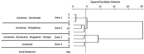
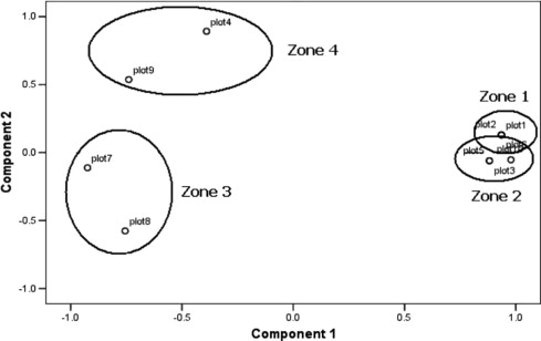
The hierarchical cluster analysis revealed a dendrogram classifying the ten plots into four clusters at a similarity level of 4.5 (Fig. 3). Each cluster was referred to as zone in this study. The results of the cluster analysis is similar to that of the principal components analysis (PCA) (Fig. 4). The principal components analysis (PCA) showed four groups of vegetation corresponding exactly to the zones of the cluster analysis. Evident from the component plot was the overlap between Zones 1 and 2, implying some commonality between these two zones. This is a normal trend in natural environments. These four zones were named after the dominant species, namely: Zone 1 – Avicennia–Sonneratia zone; Zone 2 – Avicennia–Rhizophora zone; Zone 3 – Avicennia–Excoecaria–Bruguiera–Ceriops zone; and Zone 4 – Avicennia zone.
Zone 1: Avicennia–Sonneratia zone. Zone 1 includes plots 1, 2 and 6 (Fig. 5). The highest tree recorded was a Sonneratia alba from plot 6, estimated at 15 m, while the shortest was 1.5 m both from Avicennia marina and S. alba in plot 2 (Table 1). The average height of trees in this zone was 5.1 m. The largest dbh recorded from the ten sampling plots was from S. alba (218 cm), which was also the highest tree in this zone. The largest and smallest basal areas were both observed from S. alba, at 6.53 and 0.38 m2, respectively. A. marina overtopped S. alba in dominance with respect to density (0.0875), the latter having the lowest density in this zone (0.0075).
| Zone 1 | Zone 2 | Zone 3 | Zone 4 | |
|---|---|---|---|---|
| Plots covered | 1, 2, 6 | 3, 5, 10 | 7, 8 | 4, 9 |
| Location | Ajuy | Ajuy, Pedada | Pedada | Ajuy, Pedada |
| Height max (m) | 15 | 15 | 25 | 16 |
| Height min (m) | 1.5 | 1 | 1.5 | 3 |
| DBH max (cm) | 218 | 98 | 150 | 116 |
| BA max (cm2) | 6.53 | 3.24 | 3.38 | 3.08 |
| BA min (cm2) | 0.38 | 0.01 | 0.01 | 0.06 |
| Density max (no./400 m2) | 0.0875 | 0.0850 | 0.0525 | 0.1050 |
| Density min (no./400 m2) | 0.0075 | 0.0051 | 0.0025 | 0.0025 |
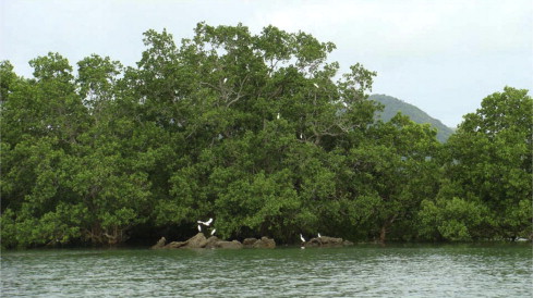
These plots were all located along the coast and had minimal human disturbance. They were not much frequented by people though they were near the community. Plot 6, specifically, was already part of a private property, and hence was not easily accessible. Additionally, seedlings of Rhizophora spp. (bakhaw) were found growing in plot 6. Per result of the key informant interview, replanting has long been initiated by the owner. This site also served as the site for the tree planting activity held in the municipality.
Zone 2: Avicennia – Rhizophora zone. Zone 2 included plots 3, 5 and 10 (Fig. 6). The highest tree was Rhizophora apiculata at 15 m from plot 3, while the shortest was a meter-high A. marina from plot 5 (Table 1). The average height of trees was 5 m in this zone. The largest dbh was from S. alba (98 cm). The largest basal area was observed from A. marina (3.24 m2) and the smallest from Avicennia sp. (0.01 m2). The highest density was recorded from A. marina (0.0850) whereas three species had the lowest, namely, Avicennia sp., R. apiculata and S. alba (0.0050).
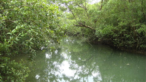
Presence and nearness of human settlement to the mangroves was observed in this zone. Access was nevertheless quite limited, especially for plot 5 since it was located inside a local’s private plantation. Acanthus spp. and Excoecaria agallocha were also noticed on the riverbank in plot 3.
Zone 3: Avicennia–Excoecaria–Bruguiera–Ceriops zone. Sampling plots 7 and 8 comprised Zone 3 (Fig. 7). The highest tree was A. marina at 25 m from plot 8 while the shortest was 1.5 m, observed from the species A. marina, Bruguiera cylindrica and Osbornia octodonta in both plots (Table 1). The average height of trees in this zone was 6.6 m. The largest dbh measured was from A. marina (150 cm), which is also the highest tree found in the zone. The largest basal area recorded was from A. marina (3.38 m2) while the smallest was from E. agallocha (0.01 m2). A. marina dominated this zone in terms of density (0.0525). Avicennia rumphiana, Ceriops decandra, E. agallocha and Thespesia populnea had the lowest densities (0.0025).
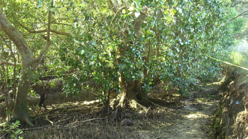
People can access the zone through plot 7 which has been a convenient path for the local fishermen to reach the sea. A channel has been observed in plot 7 as well where fishermen do fishing regularly. Mangrove associates Acanthus spp. and Sesuvium portulacastrum were found on the undergrowth in this zone.
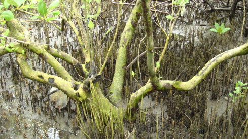
Zone 4: Avicennia zone. Zone 4 included plots 4 and 9 (Fig. 8). The highest and smallest tree were both A. marina, at 16 and 3 m, respectively, in plot 9 (Table 1). The trees in this zone had an average height of 7.3 m. The largest dbh was from A. marina (116 cm). Incidentally, the same A. marina was also the highest tree in the zone. The largest basal area was observed from A. marina (3.08 m2) while the smallest area was from A. rumphiana (0.06 m2). A. marina remained dominant in terms of density (0.1050) whereas A. rumphiana had the lowest recorded density (0.0025). Plots comprising this zone were found in between the periphery of fishponds and a watercourse (i.e., creek and river). Plot 9, notably, was located inside an abandoned pond which had been used to rear crabs in the past per narratives of key informants during interviews. E. agallocha was the only non-Avicennia true mangrove species found in the plots. Mangrove associates Acanthus spp. and S. portulacastrum were also seen growing in plot 9 of this zone.
Mangrove utilization
Results of the survey particularly on the knowledge of local residents on the use of mangrove species are presented in Table 2. The species of the genera Avicennia, Rhizophora and Sonneratia were the most popularly known among the local residents. People had been using these as fuelwood and as construction material among others. Several other species of mangroves in the area are being used as well for charcoal making, fuelwood, roofing materials, handles for fishing implements and construction materials but not so popular. This may lead to more harvesting of species belonging to Avicennia, Rhizophora and Sonneratia when there are alternative species anyway.
| Mangrove species | Use | Frequency | Percentage |
| Aegiceras spp. | Fuelwood | 2 | 1.67 |
| Avicennia marina (Forsk.) Vierh. | Fuelwood | 40 | 33.33 |
| Construction material | 44 | 36.67 | |
| Others | 19 | 15.83 | |
| Avicennia spp. | Fuelwood | 2 | 1.67 |
| Construction material | 10 | 8.33 | |
| Others | 6 | 5.00 | |
| Bruguiera cylindrica (L.) Blume | Fuelwood | 2 | 1.67 |
| Camptostemon philippinensis (Vidal) Becc. | Fuelwood | 1 | 0.83 |
| Others | 2 | 1.67 | |
| Ceriops decandra (Griff.) Ding Hou | Christmas tree | 1 | 0.83 |
| Ceriops tagal (Perr.) C.B. Rob. | Baluk | 1 | 0.83 |
| Fuelwood | 2 | 1.67 | |
| Excoecaria agallocha L. | Fuelwood | 2 | 1.67 |
| Construction material | 2 | 1.67 | |
| Others | 3 | 2.50 | |
| Lumnitzera sp. | Net handle (sibot) | 1 | 0.83 |
| Nypa fruticans (Thunb.) Wurmb. | Charcoal | 1 | 0.83 |
| Roofing material | 4 | 3.33 | |
| Rhizophora spp. | Fuelwood | 14 | 11.67 |
| Construction material | 55 | 45.83 | |
| Others | 27 | 22.50 | |
| Sonneratia alba J. Smith | Fuelwood | 36 | 30.00 |
| Construction material | 60 | 50.00 | |
| Others | 21 | 17.50 | |
| Sonneratia caseolaris (L.) Engl. | Fuelwood | 1 | 0.83 |
| Construction material | 1 | 0.83 | |
| Others | 2 | 1.67 | |
| Xylocarpus granatum Koen. | Fuelwood | 1 | 0.83 |
| Construction material | 1 | 0.83 | |
| Net handle (sibot) | 1 | 0.83 |
Discussion
Mangrove zones in Ajuy and Pedada bays (Fig. 3) have very few remaining species (Table 1). Only 13 of the 39 true mangroves reported in the Philippines (Sinfuego and Buot, 2008) were found in the study areas in Ajuy and Pedada bays. This scarcity of species is not normal. The area should have majority of the 39 mangrove species as the Philippines has been endowed by the optimum climatic conditions favorable for mangrove growth and development. Most area of the bays (Figs. 1 and 2) are now occupied by fishponds or idol lands after fishponds had been abandoned. Hence, the very low species richness.
It seems this is the general trend in southeast Asia (Doydee et al., 2008; Doydee and Buot, 2011; Tinh et al., 2009; Primavera, 1995; Primavera et al., 2004). In Thailand, salt ponds and fishponds had adversely affected mangrove ecosystem functions (Doydee et al., 2008; Doydee and Buot, 2011). In Vietnam, shrimp ponds and fishponds in large and commercial scale had alerted scientists and policy makers (Tinh et al., 2009) to do something. Scientists and local government units had recommended intercropping strips of mangroves with ponds to enhance detritus food chain. This is the aquasilviculture system of Primavera et al. (2004). Moreover, in Vietnam, lessening of artificial additives for algal enhancement in ponds had been strongly suggested. In Thailand, constructing biodiversity or landscape corridors had been recommended (Doydee and Buot, 2011) to reestablish the lost mangrove vegetation that aggravated the 2004 tsunami along Andaman Sea.
In Ajuy and Pedada, the condition is alarming considering the natural functions of the mangrove ecosystems as breeding grounds of fishes and other aquatic organisms, as sentinel of the marine waters, as guardian of the inland ecosystems and as home to numerous flora and fauna (Buot, 1994). Attention to the current issues in mangroves is all the more urgent as many people are dependent on mangrove resources for food and subsistence as the case of the local residents in Ajuy and Pedada bays. Ordinary people who solely depend on the mangroves for survival simply gather fish, crustaceans, few firewood and other products from the mangrove ecosystem (Table 2). Though, many locals in Ajuy and Pedada are practicing the sustainable way, it is very important for the local government to initiate and lead the rehabilitation efforts in the abandoned coastal lands. This will bring back the favorable ecological state of the ecosystem.
Conclusion
Species richness in the four zones of mangrove vegetation in Ajuy and Pedada bays in Iloilo, Panay Island was remarkably low due to conversion to fishponds. Despite this mangrove deforestation, local people still were knowledgeable of the uses of the remaining mangrove species. Incidentally, a huge percentage of them knew only of the uses of the species under the genera Avicennia, Rhizophora and Sonneratia. This can lead to subsequent overexploitation of these species when there are alternative species of exactly similar uses as well in the area. A holistic rehabilitation program considering the aforementioned should be started immediately. Two strategies can be initiated: (1) building of biodiversity corridors or landscape corridors, and (2) engaging in aquasilviculture system where fishponds are intercropped with mangrove trees. These two strategies however, should be enhanced and facilitated by a strong community biodiversity education program and a municipal or even barangay (village) ordinance.
Acknowledgements
The authors thank the barangay leaders, key informants and residents of Ajuy, Iloilo for warmly accommodating the conduct of this study, actively participating in the interviews and providing essential secondary data. Due thanks are also expressed to Mr. Nestor Ballentes and Ms. Cherryl Ballentes who gave invaluable time and assistance during the fieldwork for the entire duration of the study. Dr. Resurreccion Sadaba of the University of the Philippines Visayas – Iloilo, identified the mangrove specimens encountered in this study. Mr. Joe Marvin Alpuerto provided assistance with the statistical analyses while Mr. Greg Azares generated the maps. The Research Dissemination Grants of the University of the Philippines System and the University of the Philippines Open University provided funds to enable the second author to present the results of the study at the 2013 INTECOL Congress in London.
References
- Ajuy Municipal Agriculture Office, 2007 Ajuy Municipal Agriculture Office (MAO), 2007. Municipal Coastal Database. Prepared by Nenita O. Nacional – Municipal Agriculturist. Ajuy, Iloilo, Philippines (unpublished).
- Buot, 1994 I.E. Buot Jr.The true mangroves along San Remigio Bay, Cebu, Philippines. Phil. Scientist, 31 (1994), pp. 105-120
- Bunt et al., 1991 J.S. Bunt, W.T. Williams, J.F. Hunter, H.J. Clay Mangrove sequencing: analysis of zonation in a complete river system. Mar. Ecol. Prog. Ser., 72 (1991), pp. 289-294
- Doydee and Buot, 2011 P. Doydee, I.E. Buot Jr.Mangrove vegetation zones in Ranong coastal wetland ecosystem, Thailand. KU Fish. Res. Bull., 35 (2011), pp. 14-28
- Doydee et al., 2008 P. Doydee, P. Kamwachirapitak, I.E. Buot Species composition of mangrove ecosystemn in Ranong, Thailand. Thail. Natural History Museum J., 3 (1) (2008), pp. 51-58
- Hutchings and Saenger, 1987 P. Hutchings, P. Saenger Ecology of Mangroves. University of Queensland Press, St. Lucia (1987)
- NAMRIA, 2003 NAMRIA (National Mapping and Resource Information Authority), 2003. Mangrove forest map of the Philippines and Mangrove forest Statistics CY 2003. Retrieved on January 26, 2007.
- Primavera, 1995 J.H. Primavera Mangroves and brackish water pond culture in the Philippines. Hydrobiologia, 295 (1995), pp. 303-309
- Primavera et al., 2004 J.H. Primavera, R.S. Sadaba, M.J.H.L. Lebata, J.P. Altamirano Handbook of Mangroves in the Philippines–Panay. SEAFDEC Aquaculture Department, Iloilo, Philippines (2004), p. 106
- Sinfuego and Buot, 2008 K. Sinfuego, I.E. Buot Jr.Floristic composition and analysis of the true mangrove vegetation in the Philippine Islands. J. Nat. Stud., 7 (2008), pp. 83-90
- Snedaker, 1982 S.C. Snedaker Mangrove species zonation: why?. D.N. Sen, K.S. Rajpurohit (Eds.), Tasks for Vegetation Science, 2, Dr. W. Junk Publishers, The Hague (1982), pp. 111-125
- Sørensen, 1957 T. Sørensen A method of establishing groups of equal amplitude in plant sociology based on similarity of species and its application to analyses of the vegetation on Danish commons. Kongelige Danske Videnskabernes Selskab, 5 (1957), pp. 1-34
- SPSS Inc., 1998 SPSS Inc.. SPSS Base 8.0 for Windows User’s Guide, SPSS Inc., Chicago IL (1998)
- Tinh et al., 2009 H.Q. Tinh, E.P. Pacardo, I.E. Buot Jr., A.J. Alcantara Composition and structure of the mangrove forest at the protected zone of Ca Mau Cape National Park, Vietnam. J. Environ. Sci. Manage., 12 (2009), pp. 14-24
- Tomlinson, 1986 P.B. Tomlinson The Botany of Mangroves. Cambridge University Press, Cambridge (1986)
- Walsh, 1974 G.E. Walsh Mangroves: a review. R.J. Reinhold, W.H. Queen (Eds.), Ecology of Halophytes, Academic Press, New York (1974), pp. 51-174