Biocultural diversity of Yakushima Island: Mountains, beaches, and sea
Education Center, Kagoshima University, Korimoto 1-21-30, Kagoshima-shi, Kagoshima 890-0065, Japan k4057076@kadai.jp
Faculty of Environment and Information Sciences, Yokohama National University, Yokohama 240-8501, Japan matsuda@ynu.ac.jp
Abstract
Yakushima Island, which has been designated a Biosphere Reserve and World Heritage Site, has rich biodiversity and a culture that depends on the local ecosystem. The biodiversity of this island is characterized by a unique biota because the island is located at a biogeographic boundary.
The inhabitants revere nature and use natural resources from the sea, lowlands, and mountains. They have inherited a bioculture that they use throughout their lives and have close relationships with deer (Cervus nippon), sea turtles (Caretta caretta), and spotted mackerel (Scomberomorus niphonius).
The number of tourists visiting Yakushima Island increased after it was inscribed on the World Heritage List. However, most visitors do not visit the villages in the lowland areas and are not interested in the traditional biocultural diversity on the island. The residents are faced with decreasing agricultural and fishery production and the economic effects of sightseeing are limited. To conserve biocultural diversity on Yakushima and to enhance sustainability, it is necessary to create a plan for the entire island. We hope that the biocultural diversity of this island will be passed on to future generations with pride, utilizing the concept of a Biosphere Reserve.
Keywords
Biodiversity, Biosphere reserve, Cultural diversity, World Heritage List, Zoning for conservation and utilization
Introduction
Biosphere reserves are sites established by countries and recognized under UNESCO’s Man and the Biosphere (MAB) Programme to promote sustainable development based on local community efforts and sound science, since 1976. As places that seek to reconcile conservation of biological and cultural diversity and economic and social development through partnerships between people and nature, they are ideal to test and demonstrate innovative approaches to sustainable development from local to international scales. There are currently 621 biosphere reserves in 117 countries, including 12 transboundary sites (UNESCO, 2013).
There are 5 Biosphere Reserves in Japan. Shiga Highland, Mt Hakusan, Mt Odaigahara & Mt Omine and Yakushima Island were designated in 1980. Aya was designated in 2012.
Yakushima Island lies on the biogeographic boundary of the northern limit of the subtropical zone and southern limit of the Palearctic zone; consequently, it has a varied biota and rich biodiversity (Ministry of the Environment et al., 2012). The primeval forests, which include evergreen broadleaf forests, in the warm-temperature zone and large natural forest of the Japan cedar, which include trees over 2000 years old, are reasons why Yakushima Island has been designated a Biosphere Reserve (Okano, 2012).
Biome formation on the Yakushima Island has long been accompanied with human artifacts since eruption of a neighbor sea mountain heavily damaged vegetation on the island ca. 6000 years ago. The fauna and flora on the island are certainly affected by inhabitants who use the natural resources of this island. There have never been top predators such as Japanese wolves. Only hunters and hounds kills Yaku deer. (Cervus nippon yakushimae). Consequently, It certainly affects culture of the island.
This paper reports on the biological and biocultural diversity of Yakushima Island, which has been designated a Biosphere Reserve and World Heritage Site.
Brief description of nature
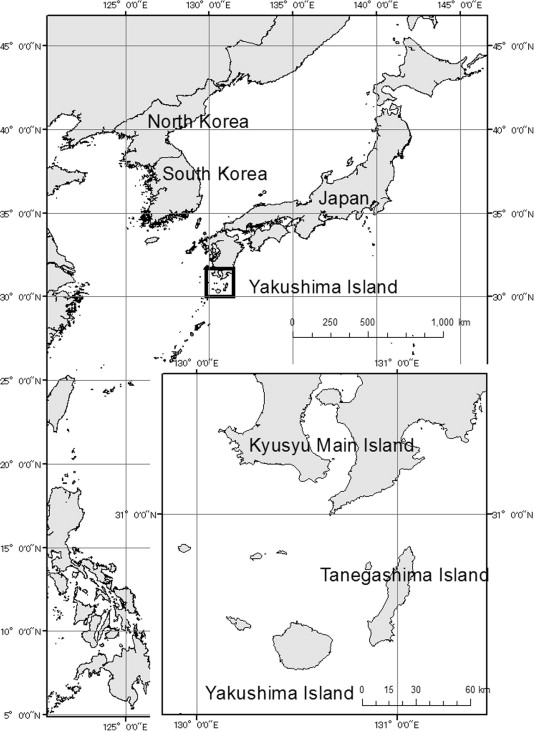
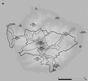
Yakushima Island, located at latitude 30°15′–30°23′N and longitude 130°23′–130°38′E (Fig. 1), has an area of ca. 500 km2 and an approximately circular perimeter of 132 km. The Yakushima Biosphere Reserve was designated in 1980 and covers 18,958 ha of the island (Japanese Coordinating Committee for MAB, 2009). The Biosphere Reserve consists of a 7559-ha core and an 11,399-ha buffer zone, with no transition zone (Fig. 2).
1. Biodiversity
The biodiversity of Yakushima Island is described mainly according to “Yakushima World Heritage Area Management Plan” (Ministry of Environment et al., 2012).
Yakushima Island, at the northern end of the Ryukyu archipelago, is separated from the southernmost tip of the main Japanese island of Kyushu by a 120-m-deep, 60-km-wide strait. The island is also characterized by mountainous landscape, with more than 30 peaks higher than 1000 m, including Miyanouradake (1936 m) that is the highest mountain in Kyushu Region (Japanese Coordinating Committee for MAB, 2009). Due to the proximity of the warm Kuroshio Current, rainfall is abundant on Yakushima, averaging 4000 mm annually in lowland areas and 8000–10,000 mm in the mountains (Eguchi, 2006).
The biota is similar to that of Kyushu, because the two were connected until about 20,000 years ago (Davison et al., 2005). However, Yakushima is located at the biogeographic boundary between the tropical and temperate regions, and all of the climatic zones of the Japanese islands, from Hokkaido to Kyushu, are condensed on this one island. The vegetation shows a vertical distribution with elevation (Fig. 3). The subtropical coastal area is home to flora such as the Japanese sea fig (Ficus superba) and Chinese banyan (F. microcarpa). Evergreen broadleaf forests grow in the warm-temperature zone from the coastline to 700–800 m a.s.l., while warm-temperature zone conifer forests composed of Japanese cedar (Cryptomeria japonica) grow above this to 1200 m. Elevations above 1200 m are home to cool-temperate conifer forests and scrub forests of dwarf bamboo (Pseudosasa owatarii), and Yakushima dwarf rhododendron (Rhododendron degronianum) grow near the summits. In the cool-temperature zone near elevations of 1600 m, there are high moors composed of peat moss and Yakushima-koke-sumire (Viola verecunda var. yakusimana). These are high moors at the southern edge of Japan. Noticeably missing on Yakushima are representative tree species of the mainland cool-temperature zone, such as Japanese beech (Quercus crispula Blume) (Research Group on ‘Biodiversity Estimation on Biosphere Reserves in Japan, 2007).
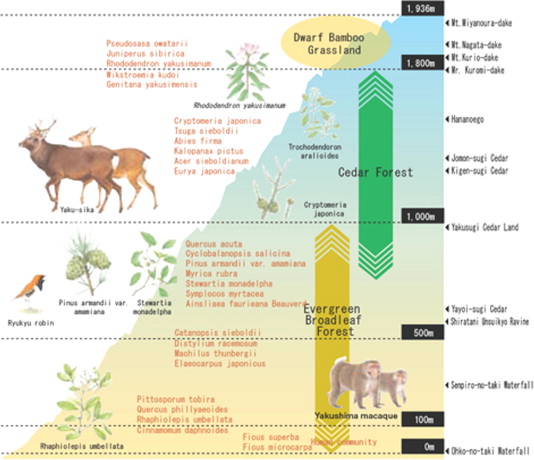
Natural Japanese cedar grows at elevations of 600–1800 m in the center of the island. These trees live up to 800 years in other areas in Japan. However, on the island, they can be older than 2000 years due to the abundant rain and high humidity, leading to slow growth. In addition, the trees high resin content makes them resistant to rot. Such trees are called yakusugi, where younger trees are called kosugi. Old-growth forests with yakusugi over 2000 years old provide unique, beautiful scenery.
There are more than 1900 plant species including ca. 600 species of moss (Ministry of the Environment et al., 2012). Yakushima Island is the southern limit for more than 230 species of plants, such as Japanese fir (Abies firma), southern Japanese hemlock (Tsuga sieboldii), and Japanese cedar, and the northern limit for ca. 70 species, such as fever nut (Caesalpinia crista) and “oni hinoki shida” (Asplenium × kenzoi) (Research Group on Biodiversity Estimation on Biosphere Reserves in Japan, 2007). Many endemic and endangered species have been confirmed on Yakushima, including species restricted to the highlands and species that grow in specific environments, such as rocky areas and mountain streams (Ministry of the Environment et al., 2012). Sixteen species of mammal have been confirmed, including four endemic subspecies: the Yakushima sika deer (Cervus nippon yakushimae), Yakushima macaque (Macaca fuscata yakui), Yakushima Dsinezumi shrew (Crocidura dsinezumi umbrina), and Yakushima small Japanese field mouse (Apodemus argenteus yakui). It is home to 167 confirmed bird species, including two endemic subspecies (Eurasian jay [Garrulus glandarius orill] and varied tit [Parus varius yakushimensis]); four species have been designated natural monuments: the Ryukyu robin (Erithacus komadori), Japanese wood pigeon (Columba janthina), Izu leaf warbler (Phylloscopus iljimae), and Izu thrush (Turdus celaenops). In addition, 15 species of reptile, 8 species of amphibian, and approximately 1900 species of insect have been confirmed on Yakushima Island, which is an extremely large biota for such a small island.
The fish of Yakushima Island were surveyed comprehensively during 2008–2009, by 10 Japanese agencies, including Kagoshima University Museum and the National Museum of Nature and Science. The survey recorded 951 species of marine (including brackish water) fish in 24 orders, 112 families, and 382 genera (Motomura and Matsuura, 2010).
2. Protected areas
Given the unique nature of Yakushima Island, it has been protected in several pieces of legislation, and is one of the most famous protected areas in Japan. Before being designated a Biosphere Reserve, this island was designated as a Special Natural Monument area in 1924, Kirishima Yaku National Park in 1964, and a Wilderness Area in 1975. The core area of Yakushima BR overlaps with Special protected area of National Park or the Wilderness Area. After its designation as a Biosphere Reserve, the area was designated a Forest Ecosystem Reserve in 1992. In 1993, this island was inscribed on the World Heritage List as a natural property, covering 10,747 hectares. The vertical distribution of vegetation and beautiful virgin forests, which include yakusugi, are reasons why Yakushima Island has been designated a World Heritage Site. In 2012, Kirishima-Yaku National Park was split in two and Yakushima and an adjacent island are included in Yakushima National Park.
Brief description of culture and society
The permanent human population on Yakushima is ca. 13,553, while tourists make more than 250,000 visits annually (Kagoshima Prefecture, 2013). The major industries are agriculture and tourism.
On Yakushima Island, mountains extend almost to the sea, and villages are in the flat subtropical coastal areas. Here, residents once grew sweet potatoes and sugar cane. Today they thrive by cultivating fruit, especially ponkan oranges (Citrus reticulata) and tankan oranges (C. tankan), flowering plants such as cymbidium (Cymbidium sp.) and other orchids, and gajutsu (Curcuma zedoaria), a herb in the ginger family that is processed into digestive medicines on the island. The name Yakushima Island is thought to originate from the fact that it was known as a medicinal island in ancient times.
Forestry was important from the 1600s until the 1970s, targeting yakusugi (C. japonica) growing mainly at elevations around 1000 m. The huge stumps of cut trees can still be seen on the mountains. Historical records and folklore suggest that prior to the 16th Century yakusugi growing at higher altitudes were revered by the local people and not harvested. This situation changed in around 1631 when Jochiku Tomari, a local Confucian, sought communion with the island’s gods and then suggested the local people to harvest some yakusugi. In Edo era, local people stored the Japan cedar as a tax to the Government, whereas rice crop was usually stored as tax (Kamiyaku Committee for Chronicling Local History, 1984).
In 1882, the forest that occupies ca. 80% area of this island was put under management of National Forest, the local people became impossible to access the forest freely. A series of petitions and suits made by the community to the Meiji and Taisho governments between 1899 and 1920, protesting the economic hardship arising from this prohibition were rebuffed until the central government eventually agreed a series of measures allowing local people regulated access under what is commonly referred to as the ‘Yakushima Constitution’ (Hayward and Kuwahara, 2013).
The local timber industry grew during the 1930s–1950s but reached its peak volume in the early 1960s, during Japan’s national economic boom. After 1955, to provide for pulp tree cutting was increase. In response, the momentum of prohibition the logging was gathered among local people and Kamiyaku Town made a request about protection of a primeval forest to National Forest in 1973. Despite of it, there were many local people who make living from forestry industry at that time. Two signature-collecting campaigns were performed simultaneously, which were prohibition of logging and continuation of forestry. It became the argument which bisects the island. In 1979, a village received serious damage because a river overflowed by the record heavy rain. The local resident claimed that the cause was deforestation, and filed the lawsuit to National Forest. It brought big impact to national forest management. Then, the area of logging was reduced gradually and the area of protected area was increased (Inamoto, 2006). There are the long conflicts between conservation and exploitation in this island.
There is limited farmland on the island because of the steep slopes, so the residents get a variety food from the sea and mountains. Typical foods from the sea are barnacles (Capitulum mitella) and Japanese abalone (Haliotis japonica), and typical foods from the mountains are Japanese butterbur (Petasites japonicus) and harlequin glorybower (Clerodendrum trichotomum). Regarding island life, the local people say, “Each month, we spend 10 days in the mountains, 10 days in the lowlands, and 10 days in the sea” (Japan Wildlife Research Center, 1996).
The local people distinguish between two mountain ranges on Yakushima Island: the Okudake and Maedake Ranges. The Maedake or front mountains can be seen from the island villages as this range is just behind the villages and is where the residents usually work. In comparison, the Okudake or back mountains dominate central Yakushima and cannot be seen from most of the island villages, except Mt. Nagata-dake and Mt. Kuromi-dake, which can be seen from the villages of Nagata and Kurio, respectively. The Okudake Range comprises strangely shaped granite rocks and rises more than 1800 m above sea level. In winter, snow falls on the high peaks of the Okudake Range.
To local people, the Okudake Range is an ancient place with very special spiritual energy. Since ancient times, these mountains have been connected with the gods; the Buddhist deity Ippon Hoju Daigongen is worshipped on Miyanoura-dake, Nagata-dake, Kurio-dake, and other mountains in the Okudake Range. The villagers in each community regularly climbed the mountains in spring and autumn to pray to the gods in a ceremony known as Takemairi, to pay respect and encourage good fortune regarding crops, fishing, and safety. This ritual goes back 1000 years. The main Miyanoura Village shrine was recorded in the “Engishiki,” a Heian era document. The Yaku Shrine is a village shrine (sato-miya) and there is a sister shrine, called Okumiya, in Okudake (Tanikawa, 1984).
In this manner, the life and culture of Yakushima Island are entwined with the residents’ relationship with the sea, lowlands, villages, and Maedake and Okudake Ranges, in a “vertical distribution of life and culture.”
Biocultural resources
There are many biocultural resources on this island. Here, the biocultural connections to three species are introduced: deer (Cervus nippon yakushimae), sea turtles (Caretta caretta), and spotted mackerel (Scomberomorus niphonius).
1. Deer
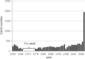
On Yakushima Island, deer have not had a natural enemy, such as wolves, unlike those on Honshu and Hokkaido, where wolves went extinct in the 20th century (Kaji et al., 2010). Deer in Japan were once threatened mainly due to overexploitation. Deer hunting was banned in the 1970s (Fig. 4). After that the deer population has recovered. Nuisance control started 1978, and game hunting of deer restarted in 2007. On Yakushima, however, game hunting is banned in the national forest, which comprises ca. 80% of the island. Kagoshima Prefecture started the Specified Wildlife Conservation and Management Plan for Deer on Yakushima Island in 2012. According to this plan, the estimated deer population on Yakushima is 12,000–16,000, in a total habitat area of 462 km2. In the western part of Yakushima BR, the deer density was >100/km2 (Tsujino et al., 2004), and the natural vegetation was heavily damaged by deer. In summer, deer appeared even in high-altitude areas of Yakushima, while deer habitat in winter is bounded in lower altitude than 300 m (Kagoshima Prefecture, 2012). This suggests deer population has been regulated by hunting for ca. 6000 years after the eruption of a sea volcano. At least during 1950–1969, the deer population was overexploited. Since 1970s, culture of game hunting and harvesting of deer has been lost on the island. Overabundance of deer is the next problem.
The MAB program encourages a sustainable relationship between humanity and nature, including wildlife management. Human control is discouraged in World Natural Heritage Sites. However, deer have a major impact on the natural vegetation in Japanese national parks, including Yakushima and the Odaigahara and Mt. Omine Biosphere Reserves. Neither overhunting nor an overabundance of wildlife is desired. Moderate control and sustainable use of wildlife is needed in the Yakushima World Heritage Site/Biosphere Reserve. In many habitats of deer in Japan, population control of deer was controversial until the end of the 20th century. Now population management programs of deer are enforced in many areas (Kaji et al., 2010).
2. Sea turtles
Every year, loggerhead sea turtles (C. caretta) come to nest on the beautiful white beaches that composed of shaved granite sand on the northwest coast of Yakushima, at Nagata: Maehama, Inaka-hama, and Yotsuse-hama. As these beaches have the greatest number of turtle nests in the north Pacific, they are crucial to the turtle lifecycle. The three beaches, collectively called “Nagatahama,” were designated as protected wetlands under the Ramsar Convention in 2005 (Ministry of the Environment, 2012).
Loggerhead sea turtles visit Nagatahama to lay eggs from May to August. It takes a female about 40 min to dig a hole and lay 100–140 eggs (Ministry of the Environment, 2012). It is estimated that 2000–3000 turtles arrive on the beach to lay eggs every year (Yakushima Umigame-kan, 2013). In the past, sea turtle eggs were an important protein source. On Nagatahama, the residents had the right to gather turtle eggs, and a successful bidder could gather and sell eggs (Kamiyaku Committee for Chronicling Local History, 1984).
Local people set up two conservation groups for the Loggerhead Sea Turtle. In 1985, the Yakushima Sea Turtle Study Group started voluntary ecological survey about sea turtle, which included counting number of sea turtle landing. In 1995, the Nagata Sea Turtle Liaison Council was organized by local community. Former has become a nonprofit organization called “Yakushima Umigame-kan” in 2001. Both of them are engaged in efforts such as monitoring, beach cleanup, nesting patrol and raising public awareness (Ministry of the Environment, 2012).
After that, the number of sea turtles landing decreased. Although, the reason was not clear, Kagoshima Prefecture prohibited the capture of sea turtles and egg gathering in 1988 because global awareness of sea turtle protection increased. In addition, Nagatahama was designated a National Park in 2002, to preserve spawning habitat. As a result, the number of turtles landing and egg production have increased since 2008 (Yakushima Umigame-kan, 2013).
However, the number of visitors going to observe egg laying also increased, and visitor control became a new problem. The Nagatahama Sea Turtle Conservation Association(organizer: the Ministry of the environment), which was composed by the Nagata Sea Turtle Liaison Council, the Yakushima Umigame-kan, Yakshima Town, Kagoshima Prefecture,etc., introduced a set of rules to keep visitors from disturbing spawning sea turtles on this beach in 2009 (Fig. 5). These rules required visitors to join tour groups guided by the local community, and to refrain from using cameras and video equipment. These local rules were devised by many stakeholders including local community.
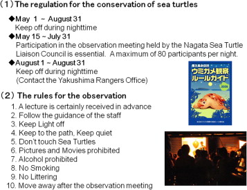
In this way, local people are leading the conservation work for the sea turtle in collaboration with government agencies to promote the protection and wise use of the nesting habitat.
3. Spotted mackerel
In Issou, a small fishing village on the north cast of the island, there are factories that dry mackerel in the traditional time-consuming, handcraft manner. This food is used to make soup with udon and soba noodles. In 2001, the Ministry of the Environment selected this factory area as one of the 100 most aromatic landscapes in Japan (Ministry of the Environment, 2001).
The fishing grounds adjacent to Yakushima are rich in spotted mackerel and bonito. In the Edo era, Yakushima Island was famous for the production of dried bonito, and in 1822, Yakushima Island was ranked as ozeki, the second highest dried bonito ranking for all of Japan. Since 1893, skipjack fishing clippers from Kyushu have operated in the seas adjacent to Yakushima Island. This forced the fishing boats from Yakushima to start catching spotted mackerel, and dried mackerel has been produced on the island since 1898 (Kamiyaku Committee for Chronicling Local History, 1984).
The traditional mackerel-drying process takes 1 year (Fig. 6). Spotted mackerel are caught in the inshore waters of Yakushima Island. The fillets are hand-cut, boiled in ground water, and smoked slowly using wood from broadleaf trees from Yakushima Island. Mold grows on the drying fish naturally, and the sun is the sole source of energy for drying. Stock abundance and catch amount of spotted mackerel in Japanese waters are more stable than chub mackerel (Fisheries Agency of Japan and Fisheries Research Agency, 2012).
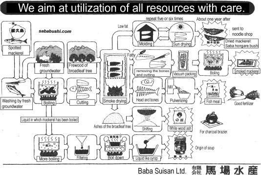
This episode suggests effects of cultural biodiversity on robustness of the community for the following reasons. Although bonitos and spotted mackerels have coexisted, only dried bonito was economically important. However, the fishers can develop a economically valuable products of dried mackerel after the fishing clippers from Kyushu Island exploited bonitos. Spotted mackerel are also exploited in Kyushu and Honshu. Fishers in Yakushima have a skill to make a good dried mackerel that are sold in Kyushu and Honshu.
All of the manufacturing waste is used. The liquid in which the mackerel were boiled is boiled down and sold as soup stock. The heads and bones are powdered and used as manure. The ashes of the wood that was burnt to smoke the mackerel are used as wood ash in charcoal braziers. The heart of the residents, who use all of the resources of Yakushima Island and waste nothing, is expressed in the process of the dried mackerel production.
Spotted mackerel is also sliced and eaten raw. To keep the mackerel fresh, the head of the mackerel is folded immediately after it is caught. For this reason, it is called “head crease mackerel” and is a famous brand.
To conserve and utilize biocultural diversity
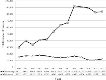
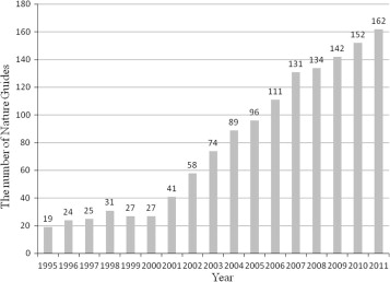
The number of tourists visiting Yakushima Island increased after it was inscribed on the World Heritage List. Jōmon sugi, the oldest yakusugi, is a very popular tourist destination, although it is a 5–6-hour hike each way from the bus stop. In the last 10 years, the number of visitors to Jōmon sugi has increased three-fold (Fig. 7). This boom has led to an increase in the number of nature guides on Yakushima Island (Fig. 8).
The World Heritage designation has created new jobs, and had a large economic effect, as shown above for tourism. Unfortunately, the visitors tend to be concentrated in specific places, like Jōmon sugi, which has had negative effects, such as traffic congestion and the destruction of vegetation. Few tourists visit the lowland villages, and few are interested in the traditional biocultural diversity of Yakushima Island. Consequently, depopulation and ageing increased on Yakushima, and agricultural and fishery production is decreasing, while the economic effects of sightseeing are limited.
To conserve biocultural diversity on Yakushima and to enhance sustainability, we need to devise an integrated plan that enhances local economy based on sustainable use of natural resources and capitals for the entire island, including policy and zoning. It is also very important that the local people rediscover their traditional bioculture and devise their own methods for conserving and utilizing bioculture. Such methods have to incorporate the economics of tourism. The concept of the MAB Program is useful for this purpose.
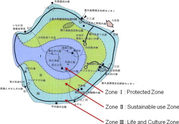
Fortunately, Yakushima Island has a local project called “The Yakushima Environmental Culture Village Concept,” which has adopted concepts similar to those of the Biosphere Reserve. The goal of this project is to enrich lifestyles, while maintaining a balance with nature. This is based on an environmental culture, which is the historical relationship between the splendid nature of Yakushima Island and its people. The Culture Village Concept has divided the island into three zones based on the inhabitants’ view of nature (Fig. 9) and developed conservation and utilization policies for each zone (Table 1).
| Zones | An explanation of each zone in terms of the relationship between humans and nature | The basic policy for utilizing environmental resources |
|---|---|---|
| Zone I Protected Zone |
The core wilderness area on Yakushima island. This zone should be protected not only as a world heritage site, but also as a space for faith and the reverence of local people | Prohibit human impacts and control visitors. Respect the historical relationship between people and nature, based on faith and a reverence for nature |
| Zone II Sustainable use Zone |
The zone where the ecosystem is conserved; limited human activity, including industry, is permitted | For nature conservation, make trails and other facilities to promote contact with nature. Promote sustainable forestry of the native trees and develop a place to experience the forestry industry. Restore degraded environments |
| Zone III Life and Culture Zone |
The zone promotes a rich culture of life harmonized with nature | Realize the benefits of a living environment that harmonizes with nature and develop infrastructure for it. Develop tourist facilities to promote the dispersion of tourists |
In the Yakushima Biosphere Reserve, it is important to secure transition areas, and it might be possible to do this through The Yakushima Environmental Culture Village Concept. In addition, it is important to create activities for sustainable development based on local community efforts in the transition areas. For example, hands-on ecotourism programs include attempts at collaboration with local fisheries and farmers. Presently, the community is conducting walking eco-tours of their villages. This has led to the rediscovery of biodiversity and bioculture in the villages. These ecotourism programs should not only reduce the overuse of popular sightseeing destinations, but also increase agricultural and fishery productions.
The Yakushima World Natural Heritage Site Scientific Council was established in 2009 to provide scientific advice on formulating a management plan and to conduct research and monitoring activities. Currently, the council is debating deer control and visitor management. When the Yakushima Island Biosphere Reserve is extended to the entire island, there should also be a Scientific Council for the entire island because it is difficult to solve both problems by taking measures only inside the World Heritage Site.
Yakushima has a management plan for the World Heritage Site, but not for the Biosphere Reserve. Therefore, a management plan for the Biosphere Reserve should be devised after sufficient discussion among local stakeholders, government, and scientists.
We hope that the biocultural diversity of this island will be passed on to future generations of residents with pride, based on the concept of a Biosphere Reserve.
Acknowledgments
The article on spotted mackerel is based on material from Baba Suisan, a factory that has made dried mackerel since 1907. We thank Baba Suisan and K. Shioya, A. Fujimaki, K. Tetsuka, Y. Higa, and M. Ohsawa, the officers of Yakushima Municipality, Kagoshima Prefecture, the rangers of the Yakushima World Heritage Center, Yakushima Forest Ecosystem Reserve, and the Japanese National Committee for MAB. We also thank anonymous reviewers for valuable comments. This research was conducted as a part of the initiative-based project E0-5 “Creation and Sustainable Governance of New Commons through the Formation of Integrated Local Environmental Knowledge,” at the Research Institute for Humanity and Nature (RIHN).
References
- Davison et al., 2005 Davison A, Chiba S, Barton NH, Clarke B., 2005, Speciation and gene flow between snails of opposite chirality (in English). PLoS Biol. 3 (9, e282).
- Eguchi, 2006 Eguchi, T., 2006. The characteristics of rain at rainy island. In: Osawa, M., Tagawa, H., Yamagiwa, J. (Eds.), World Heritage Yakushima/Nature and Ecosystem at Subtropical, Tokyo, Asakura Publishing Co., Ltd., pp. 5–11 (in Japanese).
- Fisheries Agency of Japan and Fisheries Research Agency, 2012 Fisheries Agency of Japan and Fisheries Research Agency, 2012. Marine Fisheries Stock Assessment and Evaluation for Japanese Waters (Fiscal Year 2011/2012) (in Japanese). Available from: <http://abchan.job.affrc.go.jp/digests24/details/2408.pdf> (accessed on November 7, 2013).
- Hayward and Kuwahara, 2013 P. Hayward, S. Kuwahara Divergent trajectories: environment, heritage and tourism in Tanegashima, Mageshima and Yakushima. J. Mar. Island, Cultures, 2 (1) (2013), pp. 29-38
- Inamoto, 2006 Inamoto, T., 2006. History of the forest management in Yakushima National Forest. In: Osawa, M., Tagawa, H., Yamagiwa, J. (Eds.), World Heritage Yakushima/Nature and Ecosystem at Subtropical, Tokyo, Asakura Publishing Co., Ltd., pp. 199–216 (in Japanese).
- Japan Wildlife Research Center, 1996 Japan Wildlife Research Center, 1996. Yakushima Ecotourism Guide Book, Japan Wildlife Research Center, Tokyo, p. 47 (in Japanese).
- Japanese Coordinating Committee for MAB, 2009 Japanese Coordinating Committee for MAB, 2009. EABRN Biosphere Reserve Atlas Japan. Japanese National Commission for UNESCO, Tokyo, p. 46.
- Kagoshima Prefecture, 1992 Kagoshima Prefecture, 1992. The master plan of the Yakushima Environmental Culture Village. Kagoshima, p. 286 (in Japanese).
- Kagoshima Prefecture, 2012 Kagoshima Prefecture, 2012. The Specified Wildlife Conservation and Management Plans (Yaku sika) (in Japanese) Available from: <http://www.pref.kagoshima.jp/ad04/sangyo-rodo/rinsui/shinrin/syuryo/documents/9118_20121016115707-1.pdf> (accessed on November 7, 2013).
- Kagoshima Prefecture, 2013 Kagoshima Prefecture, 2013. The Overview of Kumage Area (in Japanese).
- Kaji et al., 2010 K. Kaji, T. Saitoh, H. Uno, H. Matsuda, K. Yamamura Adaptive management of a Sika deer population in Hokkaido, Japan: theory and practice. Popul. Ecol., 52 (2010), pp. 373-387
- Kamiyaku Committee for Chronicling Local History, 1984 Kamiyaku Committee for Chronicling Local History, 1984. The chronicles of the local history of Kamiyaku, p. 1018 (in Japanese).
- Ministry of the Environment, 2001 Ministry of the Environment, 2001. The 100 Aromatic Landscape in Japan (in Japanese) Online: <http://www.env.go.jp/air/kaori/pamph/full.pdf> (accessed on November 7, 2013).
- Ministry of the Environment, 2012 Ministry of the Environment, 2012. Ramsar Sites in Japan. Online: <http://www.env.go.jp/en/nature/npr/ramsar_wetland/pamph/ramsarpamphen/yakushima.pdf> (accessed on November 7, 2013).
- Ministry of the Environment, Forest Agency and Agency for Cultural Affairs, 2012 Ministry of the Environment, Forest Agency and Agency for Cultural Affairs, 2012. Yakushima World Heritage Area Management Plan (in Japanese). Available from: <http://kyushu.env.go.jp/pre_2012/data/1001aa.pdf>.
- Ministry of the Environment, 2013 Ministry of the Environment, 2013. World Natural Heritage in Japan. Online: <http://www.env.go.jp/nature/isan/worldheritage/en/yakushima/uiversal/index.html> (accessed November 4, 2013).
- Motomura and Matsuura, 2010 H. Motomura, K. Matsuura (Eds.), Fishes of Yakushima Island, Kagoshima, southern Japan, National Museum of Nature and Science, Tokyo (2010)
- Okano, 2012 T. Okano Japanese activities in biodiversity conservation and biosphere reserves in Japan. Jpn. J. Ecol., 62 (2012), pp. 375-385. (in Japanese)
- Onodera, 1994 H. Onodera A role of zoning on Yakushima Environmental and Cultural Village Plan. Zoen-Zassi, 57 (4) (1994), pp. 356-363. (in Japanese)
- Research Group on ‘Biodiversity Estimation on Biosphere Reserves in Japan, 2007 Research Group on Biodiversity Estimation on Biosphere Reserves in Japan, 2007. Catalogue of UNESCO/MAB Biosphere Reserves in Japan. Jamanese Coordinating Committee for MAB, Yokohama National University, p. 178 (in Japanese with English summary).
- Tanikawa, 1984 Tanikawa, K. (Ed.), 1984. Gods of Japan: shrines and Sacred Sites; 1: Kyuhsu, Hakusui-sha, Tokyo, Japan, p. 472 (in Japanese).
- Tsujino et al., 2004 R. Tsujino, N. Noma, T. Yumoto Growth of the sika deer (Cervus nippon yakushimae) population in the western lowland forests of Yakushima Island, Japan. Mammal Study, 29 (2004), pp. 105-111, 10.3106/mammalstudy.29.105
- UNESCO, 2013 UNESCO, 2013. Final Report of the International Co-ordinating Council of the Man and the Biosphere (MAB) Programme Twenty-fifth session. Available from: <http://www.unesco.org/new/fileadmin/MULTIMEDIA/HQ/SC/pdf/SC-13-CONF-225-11_Final_Report_en.pdf> (accessed 7th November 2013).
- Yakushima Umigame-kan, 2013 Yakushima Umigame-kan, 2013. Research Report 1985–2012 (in Japanese). Online: <www.umigame-kan.org> (accessed on November 4, 2013).