Divergent trajectories: Environment, heritage and tourism in Tanegashima, Mageshima and Yakushima
Southern Cross University, Military Road, Lismore, Australia phayward2010@gmail.com
Kagoshima University, Kagoshima, Japan
Abstract
This article addresses aspects of contemporary heritage orientation of Tanegashima and Yakushima islands in southern Japan in the context of their historical association; the status of adjacent Mageshima island; and the divergent nature of the tourism attractions and related industries that have developed on the islands from the late 20th Century on. The discussion involves two aspects of heritage and heritage protection and exploitation; in the case of Yakushima, one focused on the natural environment and, in the case of Tanegashima, one substantially premised on historical and present-day technological refinements and innovations. As might be expected, these different orientations result in different engagements with issues of environmental protection. The islands’ divergent trajectories illustrate the range of potential developments for small islands and the problem with over-generalistic characterisations of island ‘essences’ and/or predetermined socio-economic destinies.
Keywords
Tanegashima, Yakushima, Mageshima, World heritage, Japanese space program
Introduction
Mageshima, Tanegashima and Yakushima islands, located due south of the southernmost promontory of Kyushu island, are administered by Kagoshima prefecture. While the former is now uninhabited, the latter two have well-established populations and tourism industries. But despite their proximity, and the historical associations discussed below in the pre Meiji era, the modern populations of the islands predominantly associate with – and travel between – their home islands and the prefectural capital, Kagoshima. One of the main issues that has sustained connection and a sense of common purpose between the populations in recent years has been resistance to attempts to locate ‘problematic’ facilities in the region.
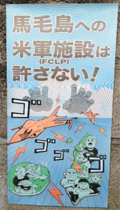
During Summer 2012, posters appeared on lamp-posts and walls around Tanegashima and Yakushima carrying a striking image and stark slogan (Fig. 1). The poster showed a manga-style representation of US jetfighters roaring over Mageshima island, sending soundwaves across the wider region, accompanied by images of the inhabitants of nearby Tanegashima and Yakushima islands shaking their fists in protest at the jets’ incursion into their airspace. The poster positions an onomatapoeic slogan around the airplane image. This phrase (which can be roughly translated into English as ‘whirr, whirr, whirr, whirr’) derives from manga usage and represents both an engine noise and an escalation of menace.1 The poster’s image and slogan refer to a plan, originally mooted in 2007 and subsequently revived in July 2011, to develop a field carrier landing practice (FCLP) airstrip on Mageshima to replace a similar facility at Iwo-To.2 FCLPs are ground-based installations that simulate aircraft carrier landing decks as training facilities for pilots, in this case, those training to join the aircrew of the USS George Washington aircraft carrier, which is permanently stationed in East Asian waters.3 The Japanese Ministry of Defence’s proposal was, in turn, part of the Japanese government’s attempt to facilitate an accelerated reduction of US forces and facilities on Okinawa and to come good on a promise to provide the US military with such a facility made in 2006, during an earlier round of negotiations on the future of US military bases in Japan.
Until 1980, Mageshima, located 12 km to the west of Tanegashima’s port city of Nishinoomote and 40 km northeast of Yakushima, was inhabited by a population that had peaked at over 500 in 1959 but steadily declined over the next two decades until its occupants voluntarily relocated to Tanegashima, seemingly leaving the island’s endangered endemic Mageshika deer to revive their population free from competition with human residents. But the vacation of the island by its human inhabitants also attracted the interest of external organisations interested to use the land area of Japan’s second largest uninhabited island for other purposes. A number of investors began to purchase vacated land on the island in the 1970s and proposed a series of development projects. As McCormack (2012) has identified, initially these involved the establishment of tourism facilities but when these did not eventuate the island was proposed as the location for first a military radar base (1983) and then an oil storage depot (1984). While these proposals met with local opposition and did not progress, development options were explored again in the late 1990s as first the Mageshima Island Development Company and then its successor, the Tasuton Airport company, acquired ownership of close to 100% of the island. After proposing the island as both a nuclear storage facility and as a landing strip for Japan’s space shuttle in the late 1990s, the company decided to develop the island as an airport facility, with a view to leasing or selling its facility to the Japanese or US military. As McCormack has identified, this example of rankaihatsu (literally ‘development gone mad’) was undertaken without prefectural permission and resulted in a situation whereby the Tasuton Company cleared large areas of vegetation and “constructed two runways, 4200 metres south-north and 2400 metres east-west” with the result that the “441 hectare forest that existed in 2002 shrank by approximately four tenths, and an airport of a scale comparable to Tokyo’s Narita or Osaka’s Kansai emerged on the uninhabited island” (2012: online). Having invested heavily in a private facility that has severely damaged the island’s eco-systems the Tasuton company has campaigned hard to get either a Japanese military lease or sale and has fostered strong association with a group of businessmen from Nishinoomote town who formed in 2011 to lobby for the FCLP facility as stimulus to the ailing local economy. These endeavours met with sustained local opposition in the form of petitions and local government lack of co-operation with proposed impact surveys.
The display of inter-island solidarity represented in the anti FCLP movement, dramatically expressed on the 2012 poster, is significant; illustrating the manner in which the Mageshima FCLP proposal has fostered a collaborative initiative that is unusual between two islands with little socio-economic association or mutually perceived social affinities. The intensity of the organised inter-island opposition campaign motivated the Governor of Kagoshima to express strong concern about the proposal to the national Government and to urge the Japanese Defence Minister to fully address local residents’ concerns before proceeding.4 At time of writing (May 2013), this concerted local opposition appears to have stalled the proposed FCLP facility but the company’s lobbying activities continue.
At face value, local opposition seems a predictable response to the incursion of high-tech, high volume aerial technology into a remote island region with distinctive local fauna and low-density population. This scenario suggests a typical ‘culture clash’ and stark division of values and ideologies. Yet this is not a characterisation that sits easily with islands’ history or present, particularly in the case of Tanegashima, where both military and aerial technologies have played a significant role in socio-economic development and have placed Tanegashima in a prominent position in Japan’s military history and in the development of its advanced aerospace industry. In terms of Yakushima’s increasing orientation to natural heritage tourism, the opposition makes more sense but, as subsequent sections detail, this local orientation itself is a recent development in a history in which environmental exploitation was an important feature.
Regional history
Archaeological research has identified that Tanegashima and Yakushima islands sustained populations as early as the mid-Paleolithic period (Ono et al., 2002) (known as the Jmon era in Japan), when the islands were still joined to Kyushu as a result of lower sea levels and lowlands connecting those higher areas that were ‘islanded’ following rising sea levels in the post-glacial period some 15,000 years ago. Research has also shown the islands had active communities in the Yayoi period (approximately 800 BC to 300 AD5), a time of increased stable settlements, when intensive rice cultivation occurred in paddy fields across Japan and there were new and sophisticated styles of bronze and pottery produced. Tanegashima’s terrain, comprising rolling low hills and flatter areas around rivers, allowed for relatively easy clearance of the dense woodlands that dominated the island in the pre-Yayoi period and the cultivation of a number of crops including, most significantly, rice, sweet potatoes and sugarcane. The production of rice, in particular, gave the island’s community an advantage over communities on adjacent islands in which rice production was more difficult due to factors of terrain and/or soil quality. Yakushima, with its narrow coastal fringe and densely forested mountainous interior (rising to 1935 metres) could only produce a limited volume of rice and was therefore dependent on importing supplementary supplies. Other products vital to local sustenance and, later, trade, on both islands included fruit and vegetable production and the seasonal harvest and drying of flying fish (which are abundant in south Japanese waters), tuna, mackerel and other species. Located to the north of the Tokara islands and south of Kyushu, Yakushima and Tanegashima have long been part of the socio-economic, political and cultural sphere of northerly powers and the local dialect, until recent years (when standard Japanese has been promulgated by education and media), was a variant of Kyushu Japanese. Documentation on the medieval history of Yakushima is scant compared to that of Tanegashima. Records of the region made by the Kyushu clans who dominated the region during the 12th Century, for instance, record information on Tanegashima’s agricultural productivity but omit reference to Yakushima altogether, due to its low agricultural output (YECVG, 2000:37). This disinterest on the part of Kyushu based clans resulted in Yakushima becoming effectively a satellite of Tanegashima, dependent on rice supplies from the latter, until the Meiji era, when this dependency loosened. Despite these strong associations and their regional proximity, the islands have experienced markedly different trajectories over the last four centuries, as the following sections detail.
Tanegashima: technology and heritage
The introduction of firearms
The origins of Tanegashima’s key role in 16th Century Japan lay in the confluence of traditional metal work skills on the island and the fortuitous arrival of two westerners with examples of advanced western technologies. In the 16th Century, Japanese contact with European powers beginning to explore and develop economic and military bases in Asia was minimal and Japan, similarly, had little awareness of or access to modern European technologies. At this time, the military forces of Japan’s various feudal chiefs were reliant on swords and bows as their principal weapons and there was a well-established tradition of highly skilled artisans producing weapons valued for their combined aesthetic and functional attributes. While small cannon were introduced into Japan from China in the 13th Century, these were essentially crude devices with limited use in conflict situations and the sword and bow and arrow predominated in the armouries of feudal militias. This situation changed dramatically in the mid-1500s. In 1543 a Chinese junk sought anchorage off Tanegashima during a storm and Tanegashima Tokitaka (the lord of the island) became aware that two westerners were on board. The gaijin (literally ‘aliens’) were two Portuguese adventurers who had in their luggage a type of early rifle known as a ‘snap matchlock’ after its firing mechanism. The snap matchlock had been developed in Europe in the late 1400s and was the predominant form of firearm, used there until the mid 1600s. Tokitaka purchased the weapons, apparently made in the Portuguese colony of Goa some time earlier in the century, and directed local metal workers to produce copies.6 Despite their skills, the metal workers were unable to produce fully functioning copies until the rifle’s mechanism was more fully explained by a subsequent Portuguese traveller, Mendes Pinto, who arrived in 1545. After this, functional copies and refinements of the Portuguese model were produced in numbers, initially in Tanegashima and subsequently more widely across Japan, where it came to be known as the tanegashima, after its local point of origin. Advanced western gun technology arrived on Tanegashima during a period of widespread civil war in Japan. Oda Nobunaga, the daimyo (regional warlord) of Owari province,7 was one of the first leaders to realise its potential and employed it to considerable advantage in consolidating and expanding his sphere of influence. This, in turn, prompted the introduction of the weapon more generally among all combatant factions, with a concomitant rise in the number, profile and value of metal workers to daimyo. This military innovation has been seen as the first step in the modernisation of Japan.8
Tanegashima’s history of gun manufacture is highlighted in the dedicated galleries in the Kaihatsu Sogo Centre in Nishinoomote, constructed in 1983. These galleries give the context for the development of Tanegashima weaponry by exhibiting early Japanese guns alongside earlier Chinese ‘hand-cannons’ and European guns from the 1500s on. The emphasis in the exhibits is on the materiality and artisanal accomplishment of the guns. Building on the association with Portugal forged (however fleetingly) at this time, other exhibits show evidence of various cultural exchanges between individuals and delegations from Portugal and Tanegashima (see Fig. 2).
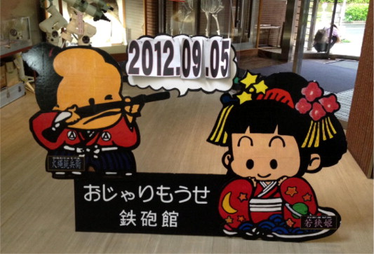
Along with the museum, the island’s gun history is celebrated in an annual festival, entitled the Nanban (‘Portuguese’) parade. This includes a small shrine carried by processioners together with other groups singing, dancing and playing taiko drums. The festival also includes a demonstration of traditional guns being discharged by adults in period clothing. In a similar celebratory vein, the island’s associations with gun culture are represented in public signs that offer comfortable representations of the lethal weaponry the local craftsmen introduced into Japan.
Local aerospace industries
Whatever their awareness of Tanegashima’s association with gun history, visitors arriving by sea at Nishinoomote port are immediately made aware of another island association, that of rocketry. As ferries slip into port the first structure they see on the outer arm of the jetty is a red-painted metal rocket. Embarking from their ferries and proceeding along the access road they encounter another large rocket statue. In terms of locational branding – and notwithstanding the strong role of gun manufacture in the island’s past – Tanegashima is ‘rocket island’ and its modern history is inextricably intertwined with that of Japan’s space endeavours.
Japanese exploration of rocket and satellite technology began one decade after the end of WW2 with the establishment of the National Aerospace Laboratory (NAL) in 19559 to develop aircraft, rockets and related technologies. NAL operated with varying degrees of collaboration with two other organisations, the Institute of Space and Aeronautical Science (ISAS), founded at the University of Tokyo in 1964, consolidating a number of separate research projects underway there since the 1950s, and the National Space Development Agency (NASDA), founded in 1969 to develop rockets and satellites for peaceful purposes under the terms of the National Space Development Agency Law. A decision was taken to house NASDA at a new location, on the south-east coast of Tanegashima. The decision to locate the base in such a sparsely populated area was taken to minimise potential impacts on and/or dangers to Japanese cities. It is significant to note that the low-profile development nature of the original project appeared to raise little concern and/or opposition in Tanegashima in the late 1960s, since Japan had no rockets to actually launch at this stage. Indeed, the facilities’ first launch didn’t occur until 1975, in the form of the engineering test satellite Kiku 1, with launches gradually increasing in frequency in the 1980s as various satellite and rocket technologies were developed, using a mixture of US and Japanese components in the H-I series of rockets.10 In the early 1990s NASDA developed an entirely Japanese made satellite launching rocket, the H-II, that attracted national interest and pride with five successful launches between 1994 and 1999 (when it was replaced by the H-IIA).
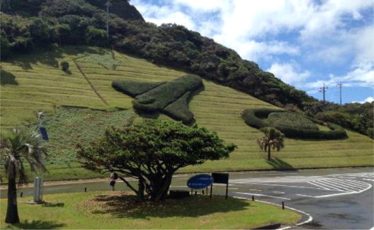
While the scientists and technicians working on the Tanegashima development and launch facility were, without exception, employed from off the island, the centre provided work for islanders in the form of labouring and support personnel and the arrival of a new group of well-paid professionals also stimulated local housing, service industry activities. In 1979 another significant event occurred for the residents of Tanegashima with the opening of a Uchu Tenjikan (‘Space Exhibition Pavilion’) near the NASDA development and launch site, which was extensively renovated and updated in 1997 and renamed the Tanegashima Uchu (‘Space’) Center in 1997.11 The latter upgrade reflected a rise in rocket-related tourism and, as pertinently, NASDA’s desire to gain increased public support and visibility for its activities. The current facilities make the best of the scenic nature of the south eastern coast of the island, comprising a custom-built multi-storey centre located close to the beach and a number of offshore islets. The area around the centre is elegantly landscaped, reminiscent of groomed parklands, and there are various decorative features including a pictorial configuration of plants on a hillside on the entrance road, representing a space shuttle in flight (complete with multi-coloured flowers representing a sparkling jet exhaust) (Fig. 3) and, on the other side, a raised plant display spelling out JAXA, the acronym of the Japan Aerospace Exploration Agency (formed in 2003 with the amalgamation of NASDA, NAL and ISAS). The landscape also includes a large model of NASDA’s successful H-II rocket and, across an area of sand, a tiered viewing platform built into the side of a rocky islet that serves press covering rocket launches from the nearby base and assembled dignitaries. The overall impression the area gives is of well-funded, highly-organised lean and green elegance – an association notably congruent with the lofty aspirations of the Centre itself, as manifest in its displays and promotional material. In keeping with the non-military nature of the Japanese aerospace program, the museum stresses the inspirational nature of the exploration of space, recalling classic 1960s space-race rhetoric and that of the early days of Science Fiction – with slogans such as “Achievements towards the infinite romance of the universe and civilization” recalling the opening narrative oration of the US TV series Star Trek (1966–69): “Space: the final frontier… to explore strange new worlds, to seek out new life and new civilizations, to boldly go where no man has gone before”. Various island tourism enterprises echo such associations in their promotion; the website for Nagareboshi – the ‘Shooting Star’ - guesthouse in Nishinoomote city, for instance,12 opens with the statement that: “Tanegashima can be identified as the closest island to the moon” and identifies that tourists can “visit the most beautiful Space Centre in the world” while staying at it (2012: online).
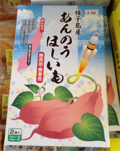
Interest in the latest launch of a H-IIB rocket carrying the Konotori 3 spacecraft on July 23rd 2012 illustrates the continuing tourism draw of the space program for the Japanese public. Conveniently coinciding with school holidays, the demand for travel and accommodation to the island for the launch overwhelmed available accommodation, car rental and transport options to the island. As Tanegashima Tourism Association spokesman Fumitaka Yamano emphasised, “Tanegashima is growing popular thanks to recent successful rocket launches, but it has never gathered such a great number of tourists before” (Unattributed, 2012: online). For Tanegashima then, rocket launches do not represent the unwelcome acoustic and environmental intrusion associated with proposals to establish a FCLP facility on Mageshima rather, they represent a lucrative tourism opportunity valued by the community with little apparent concerns over the dispersal of ignited rocket fuel contaminants in the air, ocean and land surrounding the NASDA launch site. While issues concerning pollution from rocket launch sites are not extensively documented or debated – and no research data around the rocket launch site has been made available to the public - there are major concerns over both the local and atmospheric impact of rocket launches. With regard to the terrestrial and oceanic impact of individual rocket launches from Kennedy Space Centre in the US, for instance, Patel-Predd (2007) has identified that around “23 tons of harmful particulate matter settle around the launch area each liftoff, and nearly 13 tons of hydrochloric acid kill fish and plants within half a mile of the site” (2007: online), an environmental impact from a single launch equivalent to that of New York City over a weekend (ibid). In atmospheric terms, a detailed study by Ross et al. (2009) has also highlighted the uniquely problematic effects of rocket launches on stratospheric ozone (ibid: 52). While Japan’s current program uses liquid fuels, which have less impact than solids, these also have a range of impacts. This aspect of Tanegashima is of course entirely elided in the marketing of its local food products. Perhaps the most striking example of the latter is represented in Fig. 4 above. The product is one of a number of items sold at the museum’s gift shop (along with predictable range of t-shirts and baseball caps and novelty products (such as packets of ‘Space Curry’). The product’s package’s design continues the ‘clean green’ design image of the Centre in the presentation of a classic local food product, a sweet made from the island’s famous kumera (sweet potatoes). Note the manner in which the rocket’s fiery exhaust tale switches colour to green to morph into a winding stalk that appears like a vine emerging from the sweet potato – implicitly fusing the two into an organic whole.
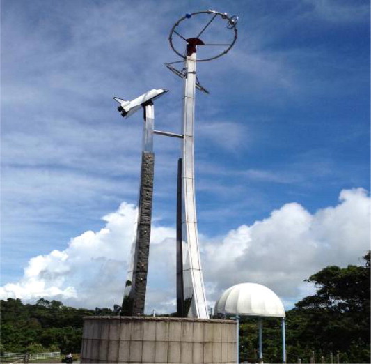
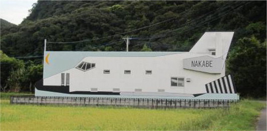
In the absence of any sustained public discussion of such issues, and/or studies in toxicity accumulation in local farmlands and fishing areas, the rocket symbolism common in tourism marketing for the island has also been integrated into symbols of the community that communicate as much to them, as a modern heritage identity, as they do to tourists. Three examples serve to illustrate this. To the south of Minamitane town, on the route taken by drivers en route to the rocket launch area, an impressive steel sculpture crowned by a space shuttle gives the town a definition that is made explicit in its accompanying signage, stating ‘Space Town Minamitane-cho’. While this statue and sign clearly ‘work’ for tourists, they also give an identity and pride-in-modernity to a small, inland town in an agricultural area that has no other obvious distinction from its surrounding communities (Figs. 5 and 6). An even more dramatic image catches the eye in Kukinaga village, closer to the launch site (Fig. 7) in the form of what appears to be a full-size space shuttle set in a field on the outskirts of the village. On closer inspection this turns out to be a community meeting hall designed and decorated so as to resemble a space shuttle. This dramatic, space themed building was designed by a local architect in 1995 at the request of a local town councillor involved in the promotion of a program entitled Uchu Ryugaku (Space Study Abroad) and opened in 1996. The program invites primary school children from main island to visit Kukinaga village during summer holidays in order to learn about space science and technology by visiting space pavilion at Tanegashima Space Center. Thus, the community hall now operates a meeting place for local people and accommodation facility for visiting school. More discretely, and in more miniature form, the space associations also form part of the functional built landscape around Kukinaga village with small stone bollards at crossroads include carved images of rocketry in a medium and style that suggests historical continuity and quiet material inscription very different from the eye-catching roadside steel structure discussed above.
One of the most striking aspects of Tanegashima is the manner in which it juggles various elements in creating a heritage identity for itself: an agricultural landscape with noted local product (such as red rice, and purple sweet potato products) that has almost entirely displaced the island’s earlier forested expanses; a history of weapons development recalled for the skill of its artisans rather than the lethal result of their trade; and a rocket launch and museum complex packaged as ‘clean and green’.
Yakushima’s re-orientation
Over the last five centuries Yakushima’s economy has been heavily dependent on various aspects of the substantial forests that cover around 90% of the island. One particular species, the Cryptomeria Japonicathe, known in Japanese as the sugi, (and often referred to erroneously as the ‘Japanese Cedar’ in English despite belonging to a markedly different genus) has played a key role. By virtue size, girth and gnarled complexity of ancient examples of the species, which have been estimated to be over 2000 years old (with massive stumps of felled trees being probably substantially older), the sugi can be regarded as an example of a form of ‘charismatic mega-flora’ that has impressed different communities for different reasons at different historical periods. Historical records and folklore suggest that prior to the 16th Century large old sugi trees growing at higher altitudes were revered by the local population and not harvested. This situation changed in around 1600 when Jochiku Tomari, a local male who initially trained as a Buddhist monk in Kyoto before travelling further afield and studying Confucianism and Chu-tzu (Mohism) returned to Yakushima, sought communion with the island’s gods and then informed the islanders that they would allow them to harvest some sugis (others being reserved as sacred) (YECF, 2000: 9). This pragmatic divine intervention allowed the islanders to begin to exploit the resource. One of the products they began to produce were hiragi, wooden tiles that – on account of the sugi’s high resin retention and longevity once cut – proved a highly durable roofing material for the islanders. While the Shimazu clan, based in Kyushu who dominated the region in the pre-Meiji era, forbade export of sugi timber from the island (for reasons that are unclear), they accepted the timber as an annual tithe and used it as a construction material and traded it Kyoto and Tokyo (ibid). The off-island control and prohibition over use of the island’s forests intensified in the Meiji era, with the forests being designated as state-owned areas, shutting the islanders out altogether. A series of petitions and suits made by the community to the Meiji and Taisho governments between 1899 and 1920, protesting the economic hardship arising from this prohibition were rebuffed until the central government eventually agreed a series of measures allowing islanders regulated access under what is commonly referred to as the ‘Yakushima Constitution’.
One of the effects of the Meiji prohibitions was to suspend harvesting of sugi for a number of decades but the situation rapidly reversed in the following decades as the islanders began timber exploitation in earnest in a designated area, with another designated as an ‘Academic Reference Forest Reserve’ on scientific grounds in 1924. In 1923 a narrow gauge railway line was constructed to enable old growth sugi and other timber to be easily extracted from the interior and a new village, named Kosugidani, was established to house the growing number of timber workers and their families. The local timber industry grew during the 1930s–1950s but reached its peak volume in the early 1960s, during Japan’s national economic boom, all but clearing old growth sugi from its designated access area. Responding to such concerns, the Government incorporated the reserve area into the Kirishima-yaku National Park in 1964.
Following a period of reduced activity, Yakushima’s timber industry permanently shut down in 1970 and Kosugidani village rapidly became uninhabited and derelict, closing one passage in the island’s history and opening another, the growth of eco-tourism. In 1975 the Government designated areas of the interior that had not been subject to previous logging as a Wilderness Area and followed this up in 1992 by also establishing a Forest Ecosystem Reserve in 1992 in the lead up to an application for World Natural Heritage site listing. The Japanese Government’s application was formulated with specific regard to three key aspects of UNESCO’s ‘Natural Property’ criteria:
- Outstanding examples representing significant ongoing geological processes, and biological evolution (with the island’s distinct vertical vegetation distribution being proposed to comprise an ecologically unique natural process in action)
- Contains unique, rare or superlative natural phenomena, formations or features of exceptional natural beauty (with the island’s ancient, large diameter sugi trees, supporting this characterisation)
- The most important and significant habitats where threatened species of plants and animals still survive (despite tourism and logging sufficient areas of the island’s unique ecosystem survive to the present). (Collated from IUCN, 1993: 1–2)
The International Union for the Conservation of Nature’s assessment of the need for and value of world heritage listing as reported to UNESCO reflected the three main factors related to the Japanese Government nomination crucial to its success: the lack of a single management area and administration; the existence of pristine wilderness pockets; and the impacts of tourism on the latter (IUCN, 1993: 2).
Reflecting the above, UNESCO’s award of world natural heritage status to Yakushima in 1993 specified the island’s attributes in the following terms, which have formed the cornerstone of subsequent eco-tourism to the island:
Located in the interior of Yaku Island, at the meeting-point of the palaearctic and oriental biotic regions, Yakushima exhibits a rich flora, with some 1,900 species and subspecies, including ancient specimens of the sugi (Japanese cedar). It also contains a remnant of a warm-temperate ancient forest that is unique in this region. (UNESCO, 1994: online)
The flora-centric nature of the application and UNESCO summary and, in particular, the identification of the island’s forests and giant cryptomeria trees (known as sugis) as key elements of its natural heritage value have been reflected in subsequent tourism, which has been heavily forest and, particularly, sugi-orientated. Prime amongst the island’s attractions is the Jōmon Sugi. So popular have visits to view the tree become that they might best be regarded as a contemporary secular pilgrimage, with many visitors travelling to the island specifically to hike up the long path to a viewing platform overlooking the tree and photograph it. Indeed such is the demand at peak holiday periods that congestion occurs at key points along the trail leading to it. Other pathways through other areas of the forested interior also allow closer (and less congested) experience of giant sugi (and other) trees. In recent years two large modern exhibition centres have complemented the actual forest-scapes, the Yakushima Environmental Culture Village Centre and the Yakusugi Nature Museum. The former includes a cinema showing a striking IMAX film of the island’s interior and the latter, detailed displays of trees and samples of old timber. Both the facilities are particular welcome additions to the tourist trade given that the island has a heavy annual rainfall and many days on which the interior is shrouded in heavy mist and clouds, rendering viewing problematic; offering visitors an alternative and/or supplement to actual experience of the island’s interior space. Unlike the mountainous interior of Kyushu, for instance, with its numerous hotels, the island’s accommodation options and amenities are distinctly low-key, prioritising the natural experience over luxurious distractions. Tourism now comprises the dominant element in the local economy, with annual visitations rising from around 250,000 in the mid-1990s to a peak of 406,000 in 2007 and is currently around 340,000.13
Along with a change of local attitudes and practices with regard to old growth forest resources, the island’s increasing reorientation towards heritage values and developing heritage tourism also affected its population’s attitude to one of its unique indigenous mammals, the Yakushima macaque monkey (Macaca fuscata yakui), a smaller sub-species of the common macaque endemic to the Japanese main islands of Kyushu, Shikoku and Honshu and a number of smaller islands off their coasts. The Yakushima macaque lives in the broadleaf forests of Yakushima’s interior and has historically been regarded as a pest by islanders at times when climatic conditions – and/or the reduction of volume of broadleaf trees by logging – prompted animals to move down into farmed land areas in search of food where they would damage citrus crops. This prompted islanders to mount annual culls in macaque numbers until the 1980s, when the Japanese Ministry of the Environment intervened by identifying it first as a rare species, in 1991, and then an endangered one, in 1998. This caused islanders, increasingly aware of the natural heritage and related tourism-related value of the island’s natural assets, to drop culling and instead focus on means of peaceful cohabitation with their fellow primates, leading to a resurgence in macaque numbers that led to them being removed from official endangered species lists in 2007.14 The present macaque numbers is estimated to be in excess of 10,000 and is a key – and highly photogenic – element of tourist visitation to the forest areas of the island’s interior, alongside the island’s Yaku deer, birds and butterflies. Yakushima’s successful retention of its macaques contrasts to the experience of Tanegashima, where extensive deforestation in the early-mid 1900s removed the areas of broadleaf forest vital to its indigenous macaque population, resulting in the species’ local extinction around 1955 (Azuma, 1972).15 This event deprived the island of a heritage resource comparable to that of its neighbouring island and is but one instance of the very different 20th Century trajectories of the islands and of the resources they have deployed to entice and gratify tourists.
Conclusion
The divergent trajectories of the three proximous islands profiled in this article over the last two centuries have provided them with diverse assets, opportunities and issues yet both the populated islands share a similarity: both have large charismatic attractions, in Yakushima’s case, its mountains and sugi and in Tanegashima’s, rocket launches. The similarities extend further. Both of these islands’ charismatic attractions invoke and evoke grandiose sentiments and perceptions. In Yakushima’s case, these involve a deeply historic natural history – a narrative of primeval trees that have escaped human interference and stand as witnesses to profound historical change. In the case of Tanegashima, with its more ‘diverse portfolio’ of historical attractions, the most inspiring is the rocket launch facility and museum, framed within a utopian Sci-Fi rhetoric of the peaceful elevation of humanity into galactic spaces. Both are also packaged as ‘green’. In the case of Yakushima’s ancient attractions, this is a given. In the case of Tanegashima’s – and the convenient elision of rocket-associated environmental pollution, it is a conceit. Yet, for both, success brings complications. For Tanegashima, the issue is whether increased rocket launches and increased tourism will imperil the environmental quality of the island. For Yakushima the issue is increasingly one of how to manage the close to 300,000 tourists who visit annually to view the island’s natural heritage assets. For Mageshima the issue is more vexed and concerns a fundamental clash over the fate of an uninhabited island and the local and national groups who have vested interests in very different outcomes. In this regard, none of the islands we discuss has attained stability, all are moving along dynamic trajectories, either exploiting their heritage assets for economic benefit whilst negotiating the new sets of pressures and issues these bring or, in Mageshima’s case, serving as a site of contestation between developers and local populations concerned with environmental issues likely to impact on the tri-island region in general.
Thanks to Henry Johnson for accompanying the authors on fieldwork to Tanegashima Yakushima in 2012 and for his comments and feedback on our early analyses.
Endnotes
References
- Azuma, 1972 Azuma, S., 1972. A case history of the extinction of the Japanese monkey population in Tanegashima Island. JIBP-CTS Research Papers 258–271.
- IUCN, 1993 IUCN, 1993. World Heritage Nomination: IUCN Summary – 662 Yakushima (Yaku-Island) (Japan). IUCN.
- Japanese Minister of Defence Mr Kitazawa, 2011 Japanese Minister of Defence (Mr Kitazawa), 2011. Press Conference (on Mageshima) Transcript. Online at: <www.mod.go.jp/e/pressconf/2011/11/111122.html> (accessed September 6th 2012).
- JAXA, 2012 JAXA, 2012. NASDA History. Online: <www.jaxa.jp/about/history/nasda/index_e.html> (accessed September 8th 2012).
- Linden, 2002 O. Linden Tanegashima: The Arrival of Europe in Japan. Institute of Nordic Studies, Copenhagen (2002)
- McCormack, 2012 McCormack, G., 2012. Mage – Japan’s Island Beyond the Reach of Law. The Asia-Pacific Journal v10 Issue 8 n3, February 20th. Online at: <http://www.japanfocus.org/-Gavan-McCormack/3694> (accessed May 9th 2013).
- Ono et al., 2002 Ono, A., Sato, H., Tsutsumi, T., Kudo, Y., 2002. Radiocarbon dates and archaeology of the late Pleistocene in the Japanese Islands. Radiocarbon v44 n2, 477–494.
- Patel-Predd, 2007 Patel-Predd, P., 2007. A Spaceport for Treehuggers: Can a green building offset the potentially giant impact of spaceflight? Discovery Magazine December. Online at: <http://discovermagazine.com/2007/dec/a-spaceport-for-tree-huggers#.UbueihmfLIo> (accessed September 8th 2012).
- Ross et al., 2009 Ross, M., Toohey, D., Peinemann, M., Ross, P., 2009. Limits on the Space Launch Market Related to Stratospheric Ozone Depletion. Astropolitics: The International Journal of Space Politics & Policy v7n1, 50–82.
- Slavin and Sumida, 2011 Slavin, E., Sumida, C., 2011. Japan offer could end Navy aircraft landings at Iwo To. Stars and Stripes July 8th. Online at: www.stripes.com/mobile/news/pacific/japan/japan-offer-could-end-navy-aircraft-landings-at-iwo-to-1.148659 (accessed September 6th 2012).
- Suzuki and Muroyama, 2010 K. Suzuki, Y. Muroyama Resolution of human-macaque conflicts: changing from top-down to community-based damage management. N. Nakagawa, M. Nakamachi, H. Sugiura (Eds.), Primatology Monographs Volume D: The Japanese Macaque, Springer, Tokyo (2010), pp. 359-374
- Unattributed, 2012 Unattributed, 2012. Tourists flock to Tanegashima for rocket launch. Japan Times Online July 19th. Online at: <http://www.japantimes.co.jp/text/nn20120719a9.html> (accessed September 12th 2012).
- YECF, 2000 YECF Diagram Yakushima (Yakushima Environmental Culture Village Guide. Yakushima Environmental Culture Foundation, Yakushima (2000)