Dusung Agroforestry Systems on Ambon Island, Central Maluku, Indonesia: Sustainable Livelihoods, Land Property Rights, and Poverty Reduction
Abstract
Forest land conversion into rice fields, palm oil, and mining caused unsustainable development, deforestation, local wisdom undermining, and persistent poverty in Maluku, Eastern Indonesia. We describe, redefine, and promote the Dusung agroforestry systems. This indigenous technology of Ambon Island is sustainable, fits the local environment, and is adaptable to community resilience to manage external disruptions. We used a partial least square-structural equational model to examine associations among land property rights, plant biodiversity, productivity, livelihoods, and poverty reduction. We surveyed 139 selected heads of households from four villages through in-depth interviews, field observation, and focus group discussions. Dusung agroforestry systems (DAFs) comprise five interdependent subsystems, from the forest to the coast, driven by embedded local values to avoid excessive land and aquatic resource use. Average annual household income from DAFs was above the poverty line, but the poverty rate was high. Agriculture, fishery, and nonfarm are complementary livelihood strategies to support household income. Per the model, secure land property rights and productivity have high performance to support agricultural income and to reduce poverty. This implies that the DAFs should improve as the guardian of community resilience to maintain sustainable ecology and poverty reduction on small islands.
Keywords
Dusung systems, land property rights, livelihoods, poverty, Ambon island
Introduction
Big islands, flat topography, and fertile land characterize continental regions. A small, short, and narrow land area, hilly topography, and small watersheds characterize small islands. Most small islands are geographically isolated from the market, have limited natural resources, are sensitive to social conflict, and have high specific but limited biodiversity (van Noordwijk, 2016). Small islands are also characterized by dependence; diseconomies of scale (Legarda, 1984); and vulnerability to natural disasters, climate change, and sea level rise (Tutangata, 2000; Asugeni et al., 2017; Hagedoorn et al., 2019).
Maluku is a small island province in eastern Indonesia. Its area 92% covered by the sea; there are 1388 islands, five big islands; and 21.5% is inhabited (BPS, 2021). Small islands have an area that is <2000 km2 but persists during high tide (Retraubun, 2013). Approximately 85% of 1198 villages are coastal (BPS, 2022). Approximately 72,473 households are farmers’ households who manage prime commodities: 44,567 acres, clove; 35,362 acres, nutmeg; and 114,731 acres, coconut (BPS Maluku, 2022). There are 52,568 households of artisanal fishers (Tiven et al., 2018). Fish potential is ~3.05 million tons annually, or 30% of the national fish production. According to the National Government Act 27/2007 and the Ministry of Marine and Fishery No 50/2017 decree, Maluku province is the national fish barn.
The gap between the potential and existing agriculture and fisheries production is substantial: the annual fish and agriculture production was ~20% of its potential (BPS, 2022). The problem is a technological gap and disconnection market among small, medium, and large enterprises. Medium and large enterprises dominate the land and aquatic resources, mainly exporting frozen shrimp, tuna, wood, and spices (BPS, 2022). Moreover, the national rice policy is biased, causing deforestation by forest land conversion into rice fields, extensive private palm oil plantations, forest rights concession (Ducos, 2014), and mining. Additionally, social disputes over land and sea borders among villages, investors, and the state have occurred (Yamazaki et al., 2018; Dharsana et al., 2021). The deforestation rate increased from 1.2% (Matinahoru, 2014) to 12.4% in protection forests, and 41.8% in production forests (Kastanya, 2019). Forest Watch Indonesia (2019) affirmed that deforestation has increased forest loss in the Moluccas by up to 1.3 million ha in the last two decades because of deforestation and mining, ~48% of the total natural forest in the Moluccas. Forest land conversion to rice field is followed by the high use of external chemical inputs that endangers the health of the land, aquatic organisms, and humans (Resosudarmo & Thorbecke, 1998; Resosudarmo, 2008) and promotes global warming. In the last 60 years, air temperature and rainfall in the Moluccas have increased by ~0.7°C–0.9°C and 10.4%–12.2%, respectively (Laimeheriwa, 2022; Laimeheriwa et al., 2019).
The following consequences of the prior and current development approaches on small islands have caused weak land property rights, exacerbated persistent poverty and inequality (Girsang, 2011), hunger vulnerability (Narayan et al., 2022), and food insecurity (Nasrudin et al., 2020). Daily consumption of people in Maluku is still <2100 kilo calories, low desirable dietary pattern, ~71, (BPS, 2023), and still the fourth poorest of Indonesia’s provinces (BPS, 2021); although the number of poor people has declined by 16.23% in 2022. The persistent problem is the urban poverty rate of 5%, but the rural poverty rate is approximately five times higher, 26.6% (BPS, 2021; BPS, 2023). Thus, most rural area residents with a low income are directly affected by the consequences of prior and unsustainable development on small islands. Thus, findings on the sustainable development of the small islands of Maluku might be generalizable to other small island regions.
Dusung systems, a sustainable alternative development model, in the Ambon Islands is adaptable to rural coastal communities and small islands’ environments. The model uses multiple cropping and widely covers islands, but the details are unclear. The concept of the Dusung is promising but under debate, particularly the complex relationship between land property rights, social ecology, and livelihood. Dusung is still debatable concept as a forest garden system (Kaya et al., 2001) and traditional agroforestry (Matinahoru, 2014) to reduce soil erosion and maintain soil fertility in a terrestrial area. Conversely, integrating terrestrial and coastal concepts has been discussed in Wattimena (2003), Wattimena (2016), and Hoshino et al. (2017). Developing conservation of soil, water, and crops has also been investigated (Montambault et al., 2005; Nuddin et al., 2019). However, studying land property rights, livelihoods, and poverty in the Dusung are limited but will provide new insights into promoting an alternative sustainable development approach for small islands.
Chheng and Resosudarmo (2021) find that secure land property rights could guarantee access to financial loans to upgrade technology to improve productivity, income, and household food insecurity in Cambodia. Zainuddin and Wibowo (2021) state land size is the most responsive variable influencing agriculture production and income in Central Java. Supriatna et al. (2022) also find that secure land property rights and extensive land size cause land conversion from forest to paddy fields and agriculture on Kalimantan Island. Although large land conversion increases profits, it creates flood and environmental devastation. Our study examines the concept of the Dusung, and conducts model analysis between secure property rights, productivity, household livelihoods, and poverty reduction.
Our first objective is to examine the narrow concept of the Dusung as traditional agroforestry in the home garden system or traditional agroforestry (Kaya et al. 2001; Matinahoru, 2014); next, we redefine the concept to be broad and comprehensive. This new concept is an alternative development approach for the integrated sustainable socioecological systems on small islands, from the terrestrial to the coastal. This paper comprehensively redefines the concept and status of the Dusung from the views of community, ecology, and economy. The second objective is understanding household income, poverty status, and livelihood strategies. The third objective is to examine the association model among secure land property rights, productivity, livelihoods, and poverty reduction.
Method
Research sites
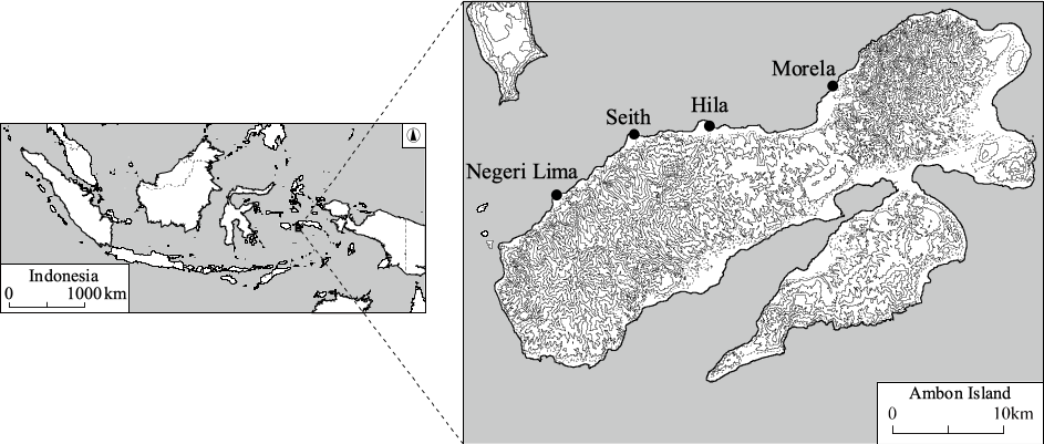
We conducted exploratory research on the Ambon Islands (~762 km2), part of the Central Maluku district, East Indonesia. In the 16th century, Ambon Island was the center of the spices trade (Turner, 2011). Central Maluku district’s population is ~425,813, 24% of the total Moluccas population; ~31% reside on the Ambon Islands. Part of Ambon Island (~360 km2) belongs to the City of Ambon; the remaining 402 km2 belongs to the Central Maluku district. This research was conducted in four villages in Central Maluku district, that is Negeri Lima, Seith, Hila, and Morela villages. These villages are less developed regions ~2 h from a city, and their transportation and communication are improving. Most residents are farmers and a small number of fishermen. (Figure 1).
Data Collection and Variables
a. Respondents
Data were collected from the field by using the following methods: in-depth interviews, household surveys, field observations, and focus group discussions. Seven enumerators were trained to administer the questionnaires. We examined 597 households across four villages. The number of samples was determined based on Yamane (1967): n = N/(N.d2 + 1), where n is a sample, N is the population, and d is a precision error at 0.1 (10%). Based on this formula, the minimum number of respondents was 85 households. However, the total sample was added to 139 heads of households.
b. Data of land property
Table 1 depicts the specific variables or latent constructs and their reflective indicators. Land property rights have three indicators: secure land property status (Supriatna et al. 2022), land size (Zainuddin and Wibowo (2021), and number of land plots or land location distribution. Secure land property rights are the respondent’s perception of the security status of the land property and are measured from very weak to very strong (Chheng and Resosudarmo, 2021). Land size is measured from very small to very large, and number of land plots is measured from low to high. We also used focus group discussion to understand the land property rights.
| Variables | Indicators | |
|---|---|---|
| 1. Land property rights | LPR1 | Secure status of land property rights |
| LPR2 | Size of land | |
| LPR3 | Land location distribution | |
| 2. Plant biodiversity | PB1 | Number of clove (Trees/HH) |
| PB2 | Number of nutmeg (Trees/HH) | |
| PB3 | Number of productive plantations | |
| 3. Plant productivity | PP1 | Clove productivity |
| PP2 | Nutmeg productivity | |
| PP3 | Clove production | |
| PP4 | Nutmeg Production | |
| 4. Agriculture income | AI1 | Plantations income |
| AI2 | Non-plantations income | |
| AI3 | Edible fruits income | |
| 5. Fishery income | FI1 | Production of Tuna Fish |
| FI2 | Fish Price | |
| 6. Nonfarm income | NFI1 | Income from trade |
| NFI2 | Total Nonfarm Income | |
| NFI3 | Income from Services and Salary | |
| 7. Poverty | Pov1 | Total expenditure for food and non-food equals to 320 kg of rice/capita/year |
| Pov2 | Food insecurity = yearly expenditure of 120 kg of rice per capita | |
| Pov4 | Food insecurity = expenditure of 57 g of protein per capita daily | |
c. Data of Plants in the Dusung
Plant biodiversity is the number of plants on the Dusung, particularly cloves, nutmegs, coconut, edible fruits, horticultures, and other food tree crops. We posited that the higher the number of valuable trees, the higher the biodiversity index in the whole system. These plants are cultivated through hierarchical multiple cropping to avoid soil erosion and risks. Plant productivity comprises four indicators: productivity of clove and nutmeg and annual production of clove and nutmeg.
d. Household income, expenditure and poverty data
Agriculture income comprises three indicators: income from plantations, non-plantations (food crops, vegetables, and livestock), and edible fruits. The indicators of fishery income are income from tuna, non-tuna and the fish price. Nonfarm income comprises trades; total nonfarm; and services, including remittances, and civil servants’ wages. Agriculture and NF income are called household income and livelihoods (Girsang, 2011). There are three poverty indicators: total household expenditure equals 320 kg of rice per capita per year, food insecurity status equals 120 kg per year, and protein consumption equals 57 g per day (Sajogyo, 1978).
Data Analysis
We used a qualitative approach to analyze the concept and the structure of the Dusung systems. Livelihoods are household income counted based on the total income of all family members from Agriculture (A), Fisheries (F), and nonfarm (NF) economic activities. We aimed to determine the contribution of agriculture to the total household income. Household poverty status is analyzed based on the Sajogyo poverty line (Sajogyo, 1978), based on a household annual expenditure equivalent to 320 kg of rice per capita in rural areas and divided into four categories: (1) not-poor (>320 kg); (2) poor (240–320 kg); (3) very-poor (180–239 kg); and (4) destitute (<180 kg).
We used the partial least squares-structural equation model (PLS-SEM) to examine the associations among secure land property rights, plant productivity, livelihoods (household income), and poverty. The PLS-SEM model is employed for prediction modeling and used broadly in marketing, management (Richter et al., 2016; Hamid & Anwar, 2019), agriculture (Chakim et al., 2019), and marine ecological systems (Huang et al., 2023). This second-generation multivariate statistical procedure does not impose distribution assumptions on the data (Garson, 2016). The advantages of PLS include the ability to model multiple dependents and independent variables, manage multicollinearity among independents, and have robustness despite data noise and missing data (Sarstedt et al., 2019). PLS-SEM is used as a dialogue between the investigator and the computer and is appropriate for exploratory and confirmatory research (Hair et al., 2017).
The aim of the PLS-SEM model analysis was to determine variance percentage through R-square values, effect size (f2), predictive relevance (Q2), and path coefficients. R square is the quality of the model that describes the influence of exogen variables on endogen variables (Chin, 1998). Effect size describes the size of the effect of exogen variables on endogen variables. The values of f2 are the operational definition of multiple regression (Cohen, 1988; Ghozali, 2021). The effect size values are categorized as big, moderate, and small: 0.35, 0.15, and 0.02, respectively. Path coefficients represent constructs’ predictiveness by using a resampling procedure called bootstrapping to obtain stability of estimation (Ghozali, 2021).
Results and Discussions
a. Concept of the Dusung
The community perceived that the ecology of the Dusung comprised five subsystems: Ewang (forest), Dusung, A'ong, 'K'abong (food crops and vegetables) and Kintal (tree crops), and coastal. The community recognized that small islands are vulnerable to external shocks. Thus, these landscape and seascape subsystems are integrated, interconnected, and interdependent, from the forest to the sea. Deforestation on the terrestrial directly affect the watershed and coastal areas. Figure 2 depicts the ecology of Dusung systems.
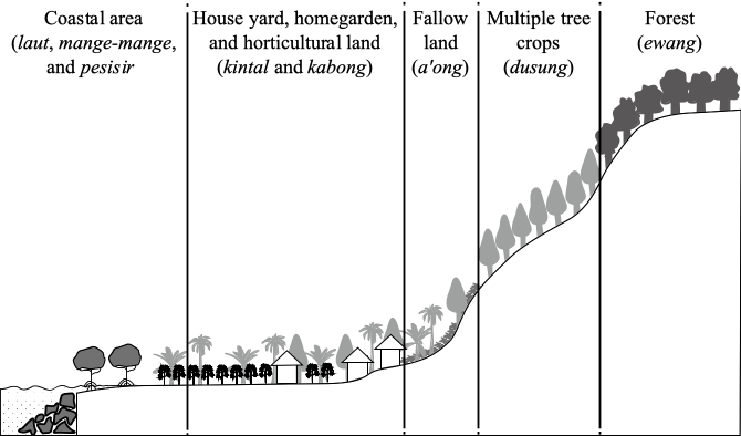
The Ewang subsystem is the first layer, called the protected primary forest at the top of the island, to preserve the environment, biodiversity, soil, and water. The primary protected forest contains essential trees, for example, Agathis (Agathis alba), mangga hutan (Ganua motleyana), and nanari (Cannarium silvetre); the latter two are alternative food sources (Table 2). The Dusung subsystem’s second layer comprises seasonal commercial plantations and edible fruits, the primary source of cash income. Clove, nutmeg, and edible fruit plantations are the land’s primary source of seasonal income. A'ong is the third layer, called the fallow land subsystem, comprising unproductive plants and weeds. 'K'abong and kintal are the fourth and fifth layers, respectively, comprising vegetables and food crops. The last layer, the coastal subsystems, comprises coconut trees, sago palm, mange-mange (mangrove), seagrass, coral reefs, and fish.
Mangroves are protected for biocultural (Buenavista and Purnobasuki, 2023), mud crab habitats, coastal land abrasion, fuelwood, and construction. Coral reefs are protected for fish-breed habitats. Sago palm trees reduce coastal land abrasion and provide starch for household food security and raw construction material. Tuna is the primary source of income from the sea. Sago starch, tubers, and fish, were the foundation of food security in the Ambon and Maluku Islands. Yamamoto (2014) found that breadfruit and tubers were the original foundation staples of food security for the indigenous people on small islands in the Federated States of Micronesia. However, these local foods have been abandoned by the communities, who now use imported rice (Girsang, 2014).
| Dusung systems | Local name | Scientific name | Primary use(s) | |||||
|---|---|---|---|---|---|---|---|---|
| Ewang |
Mangga hutan Nanari |
Ganua motleyana Canarium Silvestre |
Alternative food during difficult times | |||||
| Agathis | Agathis alba | |||||||
| Makilah | Litsa engulata | |||||||
| Dusung | Local name | Scientific name | Main use | HH | Ph | Py | Pp | Po |
| Dusung=Tree crops/Edible fruits | Durian | Durio zibethinus Mur | Fo, Ct | 44 | 11 | 32 | 62 | 7 |
| Aren | Arenga pinnata Merrill | Al, Fo | 5 | 1 | 15 | 85 | 0 | |
| Kenari | Canarium indicum L | Fo, Ct, Fu | 13 | 2 | 30 | 70 | 0 | |
| Kelapa | Cocus nucifera | Fo, Ct, Al | 8 | 4 | 8 | 12 | 1 | |
| Pala | Myristica fragnans | Sp, Fo | 89 | 60 | 33 | 53 | 14 | |
| Cengkeh | Eugenia aromaticum | Sp, Fo | 90 | 57 | 32 | 58 | 10 | |
| Kakao | Theobroma cacao L | Fo | 26 | 47 | 16 | 80 | 4 | |
| Langsa | Lansium domesticum | Fo | 67 | 23 | 29 | 65 | 6 | |
| Manggis | Garcinia mangostana L | Fo | 21 | 5 | 34 | 66 | 0 | |
| Rambutan | Nephelium lappaceum | Fo | 16 | 12 | 66 | 34 | 0 | |
| Duku | Lansium domesticum Correa | Fo | 3 | 24 | 64 | 29 | 7 | |
| Salak | Salacca zallaca var amboniensis Becc | Fo | 5 | 9 | 41 | 59 | 0 | |
| A'ong | Mangga | Mangifera indica | Fo | 7 | 3 | 42 | 57 | 1 |
| Jambu | Syzigium aqueum | Fo | 6 | 2 | 75 | 25 | 0 | |
| Alpukat | Persea Americana | Fo | 1 | 1 | 0 | 100 | 0 | |
| K'abong / Kintal | Pisang | Musa spp | Fo | 17 | 34 | 34 | 59 | 7 |
| Lemon cina | Chinese Lemon | Fo | 1 | 1 | 0 | 100 | 0 | |
| Cabe | Piper retrofractum vahl | Sp | 1 | 1 | 0 | 100 | 0 | |
| Tomat | Solanum lycopersicum L | Fo | 1 | 1 | 0 | 100 | 0 | |
| Kasbi | Manihot esculenta, Ipomea batatas, | Fo; Fe | 6 | 523 | 28 | 72 | 0 | |
| Terong | Solanum melongena | Fo | 1 | 3 | 0 | 77 | 23 | |
| Kacang Panjang | Vigna unguiculata sesquipedalis | Fo | 1 | 90 | 0 | 100 | 0 | |
| Keladi | Taro; Colocasia esculenta | Fo | 1 | 10 | 0 | 100 | 0 | |
| Sukun | Breadfruit | Fo, Fu | 70 | 2 | 3 | 100 | 0 | |
| Coastal | Kalapa | Cocos nucifera | Fo, Ct, Al | 29 | 12 | 28 | 47 | 4 |
| Sagu | Metroxylon sp | Fo, Ct, Fu, Hi | 20 | 50 | 30 | |||
| Mangrove | Rhizopora racemose | Ct, Fe, Hi | 10 | 70 | 20 | |||
| Tarumbu Karang | Coral reefs: Acropora cervicornis | Protected | 90 | 10 | ||||
| Tuna, Kembung | Katsuwonus pelamis, Rastrelliger, | Fo, Hi | Common property | 100 | 85 | 15 | ||
Regarding social ecology, the Dusung systems have high endemic plants but limited the quantity. We found at least 40 types of commodities in DAFs (Table 2). The Dusung systems use good agriculture practices and are eco-friendly because of low external inputs. DAFs maintain islands’ stability and sustainability (Stanton, 1993).
Thus, what is Dusung agroforestry on small islands? It can be viewed from two perspectives. From a partial and narrowed perspective, the concept of Dusung is defined as traditional agroforestry to prevent soil erosion and flood during heavy rain and consists of endemic multiple forest trees and agricultural crops (van Noordwijk, 2016). Dusung is traditional social cultural values (Ayawaila, 1996) to sustain natural resource use. It is a home garden that combines numbers and types of species interacting with forest trees and crops (Somarriba, 1992; Nair, 1998; Kaya et al., 2001; Matinahoru, 2014; Salampessy et al., 2017; Kastanya, 2019) to protect soil fertility, and water security (Neupane and Thapa, 2001), and reduce deforestation (Angelsen & Kaimowitz,2014). A study of the Dusung farmers’ households in the dry region of Kisar small island (Girsang et al., 2018) in Southwest Maluku and villages in Ambon city (Girsang et al., 2019) found that the Dusung is a traditional agroforestry separated from fisheries and NF.
We found that the prior concept of the Dusung is a partial, sectoral, and separate landscape from a seascape and, thus, vulnerable to unsustainable small island development. Based on fieldwork and communities’ perceptions, this study supports Wattimena (2003), Wattimena (2016), and Hoshino et al. (2017), who have stated that the Dusung is a complex system, indigenous technology, and community-based resource management that comprises hierarchical and multiple trees and crops, from the forest landscape to the coastal seascape, to protect small island environment. Thus, the concept of Dusung needs to be reshaped using a holistic, multisector, and political ecology perspective (Brown et al., 2021) to fit the new technology to local ecology and indigenous community, not vice versa. This complex system is called Dusung Agroforestry Systems (DAFs), a holistic, multisector, long-term, sustainability-oriented approach with a broad perspective. DAFs use complex indigenous technology systems, multiple cropping, low external inputs, eco-friendly and sustainable community-based management, and multisectoral, linking and integrating landscape and seascape to promote sustainable ecology and community resilience to climate change and external disruptions. This new concept of the Dusung into DAFs makes possible a comprehensive evaluation of various interactions among agroforestry and its surroundings, from the forest and land to the coastal area. This definition is also relevant to government roles according to Decree No.4/2001, in which forest, mangrove, and coral reef are the integrated domains of the Ministry of Forest and Environment, Ministry of Agriculture, and Ministry of Marine and Fisheries. The next part section supports this concept because DAFs are supported by and embedded with local institutions and household livelihood strategies.
b. Land property rights
Local institutions promote values and rules communities use to control and predict intended social behavior for sustainable small islands. Local institutions have two essential rules: sustainable rules for land tenures and natural resource use, called Sasi. These values, norms, and rules are adopted from their ancestors (Uphoff, 1986; Rugebregt, 2013; Tuhulele, 2013; Matuankotta, 2013). The primary value of local institutions is that forests and land are the mothers of the sea; thus, they are the guardians of food suppliers to the sea. The sea is not a constraint but a bridge to create connectivity between small islands. Thus, forest, plants, land and sea are integrated milieu, and the sum of the DAFs as a holistic system is more important than the sum of its parts (i.e., subsystems).
Secure ownership status of land property rights or land tenures is the foundation of DAFs. The four main types of land ownership status in DAFs are tanah petuanan negeri, tanah pemerintah negeri, tanah dati, and tanah pusaka (Uktolseja, 2013). Tanah petuanan negeri is the whole land and its territorial borders that belong to the village, from the primary forest to the coastal and sea areas; secure village land property rights protected by national law (Hajati et al., 2021). Tanah pemerintah negeri (Dusung negeri) is that the land and its plants belong to the current head of the village. Dusung dati belongs to soa (clan/families). Dati is communal land ownership; yields are shared proportionally among family members. Tanah pusaka is private land that belongs to an individual. Data showed that communal land tends to convert to private land because of a village’s population growth. Almost half the farmer households with private land had a small land size (< 1 ha) with an average land size of approximately 0.68 ha spread over two locations. The remaining farmers had medium (1.56 ha) and large land sizes (2.96 ha): 32% and 18%, respectively (Table 3).
| Land Size (area) | Villages | ||||||||||||||
|---|---|---|---|---|---|---|---|---|---|---|---|---|---|---|---|
| Seith | Morela | Hila | Negeri Lima | Total | |||||||||||
| Avg | % | Plot | Avg | % | Plot | Avg | % | Plot | Avg | % | Plot | Avg | % | Plot | |
| Small | 0.65 | 56 | 2.1 | 0.67 | 37 | 1.6 | 0.71 | 50 | 1.8 | 0.70 | 54 | 2.2 | 0.68 | 50 | 2.0 |
| Medium | 1.57 | 36 | 3.1 | 1.49 | 37 | 2.6 | 1.60 | 28 | 2.4 | 1.60 | 30 | 2.5 | 1.56 | 32 | 2.7 |
| Large | 2.67 | 8 | 3.3 | 3.00 | 26 | 2.9 | 3.00 | 22 | 3.4 | 3.00 | 16 | 3.3 | 2.96 | 18 | 3.2 |
Although land privatization decreases the farm size of land because of new resettlements, rural households continue to practice the Dusung agroforestry systems to maintain social ecology stability. Communal land property rights in the Dusung systems should be sustainable because these lands have no legal land certificate and require agreement from all family members to sell the land, and the buyer must become a citizen of the village. Land privatization did not maintain the Dusung agroforestry systems in urban areas because of excessive urbanization and needs new resettlements. This endangers the biodiversity, coastal, coral reef, and seascape ecology of small island sustainability (Ririhena et al., 2015; Supriatna et al., 2022; Pelasula et al., 2022).
Sasi is fundamental values and a well-known local customary law in rural communities to conserve natural resource stocks, including protected forests, certain plants, animals, mangroves, and coral reefs (Persada et al., 2018; Wattimena, 2003; Wattimena, 2016; Hoshino et al., 2017; Girsang et al., 2019). It is a set of prohibitive values, norms and rules, social and economic ethics, and social behavior regarding natural resource utilization. Kewang is social institution to control Sasi implementation (Figure 3).
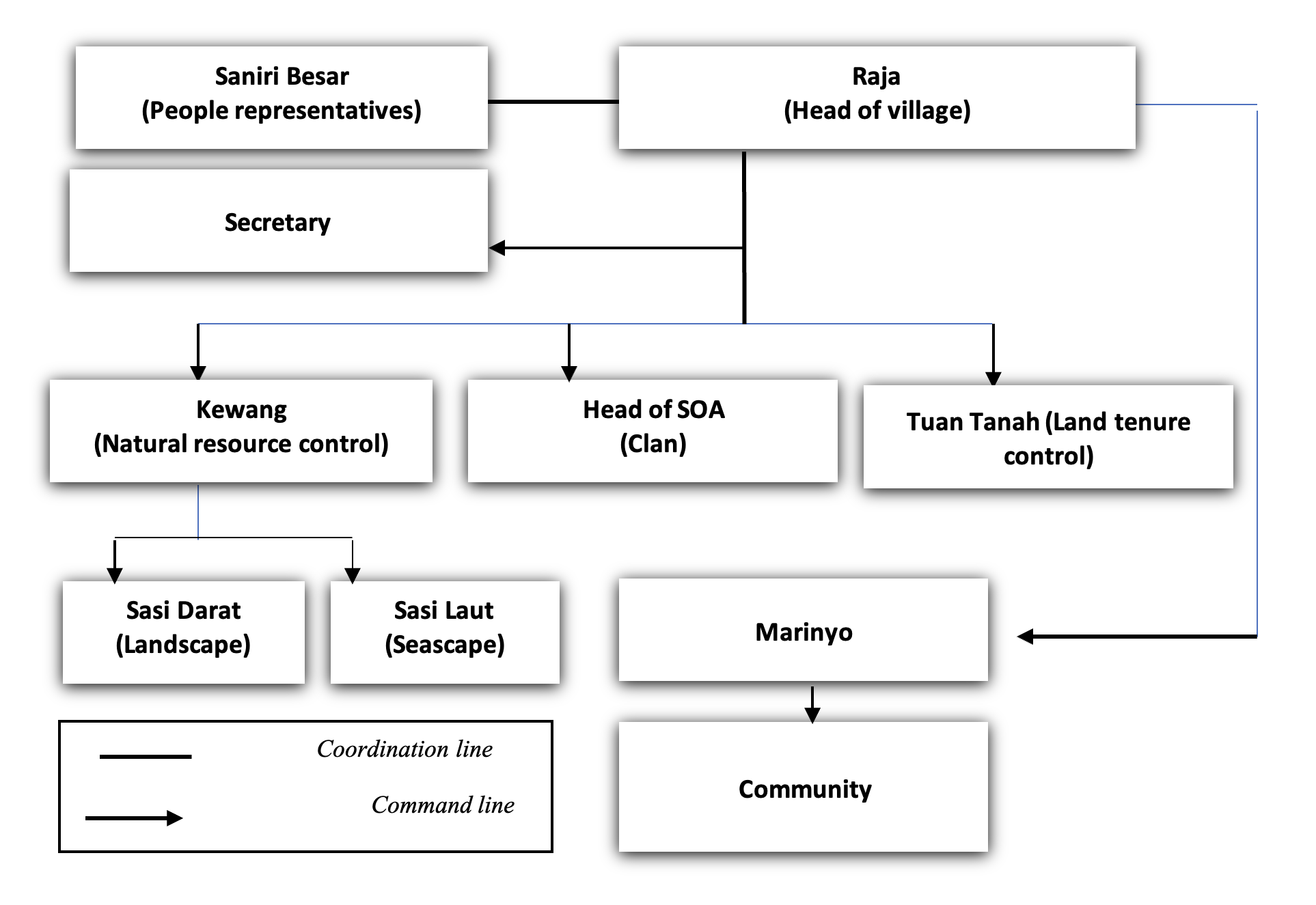
The head of the village, Saniri Negeri (villager’s representative), Tokoh Adat (local customary leaders), and spiritual leader chose the time to close and open Sasi through local institutions. Next, Marinyo (village information matters staff) announces the Sasi time while Kewang (village security) observes and controls the implementation. Sasi is applied by the village government and used by personnel to protect private plant property from theft. The main objectives of Sasi are to avoid excessive natural resource exploitation, social insurance, equality, and preserving the environment. Sasi ikan lompa (Thrissina baelama) and Sasi kelapa (coconut) were found on the Ambon and Lease Islands; Sasi of sea cucumber (Holothuridae spp) and Sasi bia-lola (Trochus niloticus) were found on the Kei Islands.
Based on residents’ perceptions, secure communal land property rights and Sasi in DAFs can incentivize them to manage the ecosystems properly and productively, increasing biodiversity and productivity. Thus, the holistic, multisector approach of DAFs is pivotal in maintaining a connection between the community and securing communal land property rights. This new concept of the Dusung as DAFs makes possible a comprehensive evaluation of various interactions among agroforestry and its surroundings, from the forest and land to the coast.
c. Household livelihoods strategies and poverty
Heads of households in coastal rural areas had two primary occupations: farmer and fisherman. Most farmers had secondary occupations: NF and fisheries. Few fishers had NF jobs. Notably, 96.4% were farmers: 17.3% had primary agricultural jobs; and the remaining individuals, 6.5%, 68.3%, and 4.3%, had secondary occupations in fisheries, NF, fisheries and NF, respectively. Thus, 79.1% of farmers had secondary jobs in agriculture, fisheries, and NF. In summary, 74% of respondents (72.6% farmers and 1.4% fishers) were involved in NF. Most farmers were of older adults and uneducated. Children were more educated than older adults but disliked farm work. Of the educated children, 58.4% were unemployed, 26.4% were farmers, and the remaining individuals worked informally (Table 4).
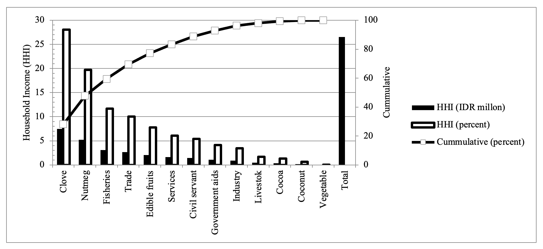
Because farmers and fishers had primary occupations, prime commodities were their primary source of income. Farmer’s prime commodities were clove, nutmeg, and edible fruits. The prime commodities of fishers were tuna (Katsuwonus pelamis) and kembung (Rastrelliger sp). NF jobs are complementary to the primary occupation. As shown in Table 5, agriculture was essential in supporting annual household income, estimated at IDR 26.58 million. Agriculture, NF, and fisheries contributed 59.37%, 29.53%, and 11.10%, respectively. The percentage of agriculture income was approximately five times higher than that of fisheries and twofold higher than that of NF. The highest agriculture income contribution was from clove and nutmeg, followed by edible fruits (Figure 4). The highest contribution of NF was from trade and services. Clove, nutmeg, fisheries, trade, edible fruits, and services are crucial livelihoods because they contributed >80% to household income.
Figure 5 shows the income distribution inequality based on the distinctive source of income from agriculture, fisheries, or both from farm and off-farm (nonfarm). Different from the fishery, the distribution of agricultural income had high inequality because approximately 40% of the lowest incomes received <10.5% of the total agricultural income (Figure 5a).
This was because the bottom 40% of poor households in agriculture relied only on small-size farms, low productivity, and low income from NFs (Table 6). By contrast, fisheries and off-farm had low inequality. Using the poverty Gini index, farmer income inequality in the Dusung systems was 0.34 or low-medium inequality (Figure 5b). This inequality was almost the same as the provincial Gini index, which was 0.343 (BPS, 2019) but lower than that of the national Gini index by 0.381 (BPS, 2021).
| Characteristics | Village (%) | ||||
|---|---|---|---|---|---|
| Seith | Morela | Hila | Negeri Lima | Total | |
| 1. Primary occupations of head of household (HH) | |||||
| a. Farmers/livestock | 17.1 | 10.0 | 30.6 | 10.5 | 17.3 |
| b. Farmer–Fisher | 0.0 | 16.7 | 5.6 | 5.3 | 6.5 |
| c. Farmer–Nonfarm (NF) | 80.0 | 63.3 | 58.3 | 71.1 | 68.3 |
| d. Farmer–Fisher-NF | 0.0 | 3.3 | 5.6 | 7.9 | 4.3 |
| e. Fisher | 2.9 | 3.3 | 0.0 | 2.6 | 2.2 |
| f. Fisher–NF | 0.0 | 3.3 | 0.0 | 2.6 | 1.4 |
| 2. Age of Head of HH | |||||
| a. Young (<40) | 16.7 | 26.7 | 8.3 | 5.3 | 13.6 |
| b. Moderate (40–50) | 25.0 | 13.3 | 27.8 | 21.1 | 22.1 |
| c. Old (>50) | 58.3 | 60.0 | 63.9 | 73.7 | 64.3 |
| 3. Head of HH education | |||||
| a. No school | 0 | 0 | 2.8 | 2.6 | 1.4 |
| b. Elementary | 38.9 | 30 | 36.1 | 52.6 | 40.0 |
| c. Junior high school | 30.6 | 33.3 | 33.3 | 15.8 | 27.9 |
| d. Senior high school | 22.2 | 36.7 | 25.0 | 28.9 | 27.9 |
| e. Academy/Graduate | 8.3 | 0.0 | 2.8 | 0.0 | 2.9 |
| 4. Family dependency (people) | 5.1 | 4.5 | 4.3 | 4.7 | 4.6 |
| 5. No. of children (people) | 3.2 | 2.8 | 2.4 | 2.9 | 2.9 |
| 6. Children’s occupation | |||||
| a. No job (Unemployment) | 71.2 | 52.2 | 61.9 | 48.1 | 58.4 |
| b. Farm | 19.2 | 26.7 | 31.0 | 29.8 | 26.4 |
| c. Nonfarm | 9.6 | 21.1 | 7.1 | 22.1 | 15.2 |
| 7. Children education (age > 15 years) | |||||
| a. No education | 14.4 | 6.7 | 9.5 | 9.6 | 10.2 |
| b. Elementary school | 26.0 | 12.2 | 16.7 | 19.2 | 18.8 |
| c. Junior high school | 13.5 | 25.6 | 20.2 | 10.6 | 17.0 |
| d. Senior high school | 29.8 | 33.3 | 36.9 | 36.5 | 34.0 |
| e. Academy/University | 16.3 | 22.2 | 16.7 | 24.0 | 19.9 |
| No | Livelihoods | IDR million | Agriculture/ Fisheries/Non-farm (%) | Total (%) |
|---|---|---|---|---|
| A | AGRICULTURE | 15.78 | 100 | 59.37 |
| 1 | Plantations | 13.04 | 82.64 | 49.06 |
| a Nutmeg | 5.19 | 32.89 | 19.53 | |
| b Clove | 7.33 | 46.45 | 27.58 | |
| c Coconut | 0.16 | 1.01 | 0.60 | |
| d Cacao | 0.36 | 2.28 | 1.35 | |
| 2 | Edible fruits | 2.03 | 12.86 | 7.64 |
| 3 | Sago and tubers | 0.26 | 1.65 | 0.98 |
| 4 | Vegetables | 0.01 | 0.06 | 0.04 |
| 5 | Livestock | 0.44 | 2.79 | 1.66 |
| B | FISHERIES | 2.95 | 100 | 11.10 |
| C | NONFARM | 7.85 | 100 | 29.53 |
| 1 | Small industries | 0.94 | 11.97 | 3.54 |
| 2 | Trades | 2.78 | 35.41 | 10.46 |
| 3 | Services | 1.55 | 19.75 | 5.83 |
| 4 | Salary (civil servants) | 1.49 | 18.98 | 5.61 |
| 5 | Government aids | 1.09 | 13.89 | 4.10 |
| D | TOTAL | 26.58 | 100 |
As shown in Figure 6, approximately 71.22% were categorized as not-poor, and 28.78% were classified as poor, very-poor, and destitute households (Sajogyo, 1978): 14.39%, 12.23%, and 2.16%, respectively. The size of farmland is the main reason for categorizing poor households (Jerneck and Olson, 2013). Individuals with low incomes and little land are called subsistence peasants. The non-poor with surplus land are called supra-subsistence. Except for the destitute, the very-poor and the poor and non-poor households had applied for multiple livelihoods strategies. Notably, 97.84% of households had multiple occupations; the percentage was higher in non-poor households.
We showed that although most households have multiple occupations, agriculture or fisheries remain the foundation of the household economy. Van Oostenbrugge et al. (2004) found that farmers or fishers have multiple occupations in the Central Maluku Islands because they primary occupations are at high risk, uncertain, and provide insufficient income to fulfill the household basic needs. Thus, most households have no specialization. Further, Babatunde (2013) found that farmers applied for NF jobs to substitute farm income, which is insufficient to support the basic needs of households in developing countries. White (1990) and Girsang (2011) found that NF occupations are complement to farm income. This is supported by Ellis (1998), who found that coping with and withstanding economic shocks depends on choices in terms of capabilities, capital assets (material and social), and activities. Walker et al. (2001) found that rural households organized lifestyle choices, goals and values, and activities influenced by multiple factors, including productivity, political (rules), economic, social (demographics, cultural (beliefs), and psychological components. Thus, in this DAFs study, the multiple occupations found could be built because of local livelihood strategies’ considering a trade-off of limited labor forces of family members among the activities, the limitation of the technology, and low productivity and profitability in agriculture and fisheries. Rice farmers have a legal land certificate as collateral to obtain bank loans (Chheng & Resosudarmo, 2021) to improve technology and productivity (Nuddin et al., 2019; Dumas-Johansen & Thulstrup, 2021), but farmers in the DAFs do not. They do not have financial access to improve technologies and productivity through a multisector partnership.
Notes: Farm = Agriculture, Livestock and Fisheries; Off-farm (Nonfarm) = Industry, trade and services
Suadi et al. (2022) found that artisanal fishers have high livelihood vulnerability to climate change, thus they apply intensification strategy because of limited financial capital and high dependency of fish resources. We identified three essential reasons as rural coastal household livelihood strategies. First is the survival strategy: poor households entered NF and fishery because of insufficient income from agriculture. Second is the consolidation strategy: near-poor households entered NF and fishery because agricultural income is sufficient; however, they had multiple occupations in NF to avoid risks because agriculture or fishery income is uncertain and vulnerable to external shocks such as inflation, fluctuating commodities prices, harvest failure, and climate changes. Third is the accumulation strategy: the non-poor households entered NF and fishery because they had achieved a surplus from agriculture to accumulate capital assets, intensify technology, and expand existing businesses.
d. Model Analysis of DAFs: Land Property Rights, Livelihoods, and Poverty
We have applied qualitative approaches to describe the associations among land property rights, household income (livelihood), and poverty in DAFs. In this section, we discuss the quantitative model analysis using the PLS-SEM. The basic requirements for a good measurement model are reliability and validity. The measurement model is reliable because loading factors are more than 0.7 and composite reliability and Cronbach’s alpha are more than 0.7. The values of the average variance extracted are >0.5. This implies that indicators are reflexive, reliable, and can be used to explain >50% variation values in each latent variable (Table 6).
| Constructs/Indicators | Indicators | Item reliability | |||
|---|---|---|---|---|---|
| Loading | Cronbach's alpha | Composite reliability (rho_a) | Average variance extracted (AVE) | ||
| Agriculture Income | 0.781 | 0.844 | 0.676 | ||
| AI1 | Plantations income | 0.830 | |||
| AI2 | Non-plantations income | 0.795 | |||
| AI3 | Edible fruits income | 0.840 | |||
| Fishery Income | 0.701 | 0.745 | 0.766 | ||
| FI1 | Fish production | 0.914 | |||
| FI2 | Fish value price | 0.835 | |||
| Land Property Rights | 0.821 | 0.932 | 0.736 | ||
| LPR1 | Level of secure land property rights | 0.956 | |||
| LPR2 | The size of the land | 0.896 | |||
| LPR3 | The number of land plots | 0.700 | |||
| Non-farm Income | 0.714 | 0.742 | 0.635 | ||
| NFI1 | Trade income | 0.730 | |||
| NFI2 | Total non-farm income | 0.896 | |||
| NFI3 | Services income | 0.754 | |||
| Plant Biodiversity | 0.754 | 0.772 | 0.671 | ||
| PB1 | Number of cloves | 0.861 | |||
| PB2 | Number of nutmeg | 0.733 | |||
| PB3 | Total plantations | 0.857 | |||
| Plant Productivity | 0.814 | 0.838 | 0.639 | ||
| PP1 | Clove production | 0.815 | |||
| PP2 | Nutmeg production | 0.751 | |||
| PP3 | Production of clove per tree | 0.838 | |||
| PP4 | Production of nutmeg per tree | 0.790 | |||
| Poverty | 0.733 | 0.748 | 0.649 | ||
| POV1 | Annual household expenditure | 0.888 | |||
| POV3 | Level of carbohydrate consumption | 0.774 | |||
| POV4 | Level of protein consumption | 0.749 | |||
The model is also valid because it fulfills discriminant and convergent validity: some AVE values were >0.5 (Table 6); for the Fornell-Larcker Criterion, the root square of the variables was more significant than that of the correlation between constructs; and the value of Heterotrait-Monotrait (HTMT) ratio was <0.9. Thus, we posit that the model fulfilled validity requirements (Table 7).
Next, we examine the model. A model is fit when it has several indicators, including standardized mean root square (SRMR), goodness of fit (GoF) index, robustness (linearity and heterogeneity), and PLS prediction.
| Variables | AI | FI | LPR | NFI | PB | PP | POV |
|---|---|---|---|---|---|---|---|
| Fornell–Larcker criterion | |||||||
| AI | FI | LPR | NFI | PB | PP | POV | |
| AI | 0.822 | ||||||
| FI | −0.291 | 0.875 | |||||
| LPR | 0.497 | −0.103 | 0.858 | ||||
| NFI | −0.231 | −0.155 | 0.017 | 0.797 | |||
| PB | 0.424 | −0.119 | 0.510 | −0.095 | 0.819 | ||
| PP | 0.781 | −0.277 | 0.398 | −0.172 | 0.384 | 0.799 | |
| POV | −0.111 | −0.263 | −0.195 | −0.106 | −0.141 | −0.109 | 0.806 |
| Heterotrait-monotrait ratio (HTMT) - Matrix | |||||||
| AI | FI | LPR | NFI | PB | PP | POV | |
| AI | |||||||
| FI | 0.348 | ||||||
| LPR | 0.569 | 0.180 | |||||
| NFI | 0.287 | 0.216 | 0.084 | ||||
| PB | 0.491 | 0.165 | 0.632 | 0.129 | |||
| PP | 0.870 | 0.369 | 0.415 | 0.248 | 0.455 | ||
| POV | 0.177 | 0.354 | 0.251 | 0.190 | 0.212 | 0.146 | |
The value of SRMR was 0.085, almost the same as the SRMR recommended: <0.08 (Hair et al., 2021) or <0.1 (Karin Schemmeleh et al., 2003). In this study, the GoF for agriculture income and poverty was 0.49 (high) and 0.24 (moderate), respectively. The model is also robust because it fulfilled the linearity and heterogeneity requirements. Linearity is observed from the quadratic effect (QE) values of exogen variables: plant biodiversity, plant productivity, agriculture income, fishery income, NF income, and poverty were >0.05. The model also shows that the data are from the same segment because the heterogeneity test shows that the value of the normed entropy statistic for one segment is zero or more negligible than that of the entropy statistic for two segments.
A model is called fit when it has good prediction. The PLS-SEM model has good prediction when most of the values of the PLS-SEM_RMSE are smaller than the value of the linear model RMSE. Research showed that 11 of 18 dependent variables indicators of RMSEPLS were smaller than RMSELM. Thus, the model has moderate predictive power because most indicators in the PLS-SEM analysis have lower RMSE values than the naïve LM benchmark (Table 8).
| Q²predict | PLS-SEM_RMSE | LM_RMSE | RMSEPLS-RMSELM | |
|---|---|---|---|---|
| AI1 | 0.188 | 3.015 | 2.94 | 0.075 |
| AI2 | 0.066 | 1.758 | 1.77 | −0.012 |
| AI3 | 0.186 | 2.102 | 2.109 | −0.007 |
| FI1 | −0.003 | 440.177 | 465.552 | −25.375 |
| FI2 | 0.004 | 14377.989 | 14711.209 | −333.22 |
| NFI1 | −0.004 | 1.121 | 1.132 | −0.011 |
| NFI2 | −0.013 | 1.673 | 1.692 | −0.019 |
| NFI3 | −0.026 | 1.383 | 1.384 | −0.001 |
| PB1 | 0.155 | 32.599 | 32.127 | 0.472 |
| PB2 | 0.12 | 41.483 | 41.767 | −0.284 |
| PB3 | 0.194 | 53.494 | 52.928 | 0.566 |
| PP1 | 0.085 | 1.647 | 1.568 | 0.079 |
| PP2 | 0.037 | 1.971 | 1.91 | 0.061 |
| PP3 | 0.186 | 2.159 | 2.022 | 0.137 |
| PP4 | 0.021 | 2.327 | 2.281 | 0.046 |
| POV1 | 0.009 | 1.634 | 1.669 | −0.035 |
| POV3 | 0.014 | 1.516 | 1.523 | −0.007 |
| POV4 | 0.006 | 1.057 | .086 | −0.029 |
Figure 7 shows the complete associations between independent and dependent variables whilst the direct and specific indirect effects are depicted in Table 9. We derived seven hypotheses from the model. Hypothesis 1 to 6 were direct effects, and hypothesis 7 was indirect. Hypothesis 1 showed that plant biodiversity was influenced significantly by land property rights. The path coefficient value indicated that land property rights affected plant biodiversity by 0.51, with a value at a 95% confidence interval between 0.399 and 0.616. Thus, an improvement in land property rights will improve 0.51 units of plant biodiversity.
The confidence interval value showed a range of improvement from 0.399 to 0.616 units. This was followed by the variance inflation factors (VIFs), effect size (f2), coefficient of determination (R2), and predictive relevance (Q2): 1.00, 0.351, 0.260, and 0.161, respectively. According to Chin (1998), the value of VIF should be <5. The value of upsilon v is used for the f2 value in the indirect, specific effects. The upsilon v is defined as low, moderate, and high when the values are 0.02, 0.075, and 0.175, respectively. Thus, land property rights have no collinearity, low R2, and low predictive relevance but significantly improve plant biodiversity. This implies that more substantial land property rights, secure communal land ownership, increased land size will significantly improve plant biodiversity with a large effect size in DAFs.
Hypothesis 2 showed that plant productivity was influenced significantly by land property rights and plant biodiversity. The path coefficient value can be improved from 0.2 to 0.4 units, although the effect, R2, and Q2 size were small. When land property rights and plant biodiversity are improved, plant productivity will improve significantly. Focus group interviews and field observations showed that the root problem of coastal rural households was low productivity. Productivity of clove is up to 64 kg/acre or between 1 and 10 kg per tree (average 2.3 kg), and nutmeg productivity is 292 kg per acre, approximately 1 kg and 15 kg per tree, respectively (average 2.9 kg per tree). The number of productive clove and nutmeg trees was low, between 30 and 45 per acre. Similar to plant productivity, fisher’s productivity was low: approximately 141 trips per year, and average production was nine tails of skipjack tuna or 11 kg of kembung fish (Rastrelliger) and layang fish (Decapterus sp) per trip. Farmers require innovation to improve land fertility, control pests and diseases, rejuvenate old-age farmers, regenerate unproductive plants, and apply high-yield seed varieties (Rehatta et al., 2016). Fishers must also rejuvenate old-age fishers and upgrade fishing gear technology. Field observation showed that 74% of fishers used conventional technology: canoe without motor (26%), katinting (37%) used 15 PK, and the remaining 37% used 30 PK semi-modern boat motors.
Hypothesis 3 showed that agriculture income was influenced significantly by plant productivity, land property rights, and plant biodiversity. The path coefficient value of plant productivity was high, followed by large effect size, an almost high coefficient of determination (65.3%), and high predictive relevance (0.376). Low productivity causes low household income. Farmer apply multiple plants to reduce risks, and then save 10-15 kg of clove that will be sold during the difficult time. Besides, fishers apply local wisdom which is called nanaku, that is a time to go fishing by considering sea wave, the time for specific fish to look for feeds on a specific location, and the signs of nature and weather.
The annual household income was approximately IDR 26.58 million (USD 1898.6): approximately IDR 481,522 per capita per month. This income is higher than the Central Maluku district poverty line, approximately IDR 431,512/per capita/month in 2018 (BPS, 2019). The average daily income of research sites was approximately IDR 16,051/capita. By using USD PPP (purchasing power poverty), if USD 1 equals IDR 7500 at the research sites, the daily income per capita is USD 2.14/capita/day. This average income was higher than the poverty line, although 28.78% of rural households were still poor.
Hypothesis 4 showed that agriculture and fishery income significantly influenced NF income; hypothesis 5 showed that agriculture income significantly influenced fishery income. Thus, fishery and NF are complementary to agriculture income. The value of effect size, R square, and Q square was low. This implies that the household has a specialty: agriculture as the prime occupation. Fishery and NF are complementary rather than substitution occupations to agriculture. The reasons of each head household differed regarding entering fishery and NF as secondary occupation.
Hypothesis 6 showed that poverty is influenced significantly by agriculture, fishery, and NF income: the path coefficient was between −0.274, −0.378, and −0.228, although with low effect size, R square, and Q square. Poverty can be reduced by improving agriculture, fishery, and NF income to −0.062, −0.218, and −0.076, respectively. Direct poverty reduction is possible by improving agriculture, fishery, and NF livelihoods.
Hypothesis 7 also showed that secure land property rights indirectly influenced poverty reduction (path coefficient −0.051) by improving plant productivity and agriculture income. Plant productivity also significantly influenced poverty (path coefficient −0.186) by improving agriculture income. A low level of upsilon v (<0.075) shows that secure land property rights and productivity can reduce poverty rate up to −0.007 and −0.043, respectively. This implies that reducing poverty requires simultaneous actions, including to sustain secure land property rights, increase plant productivity, and enhance agriculture, fishery, and NF income.
| Path/Hypothesis | Path Coeff | t Statistic | p values | 2.5% | 97.5% | Sig? | VIF | f2 | R2 | Q2 |
|---|---|---|---|---|---|---|---|---|---|---|
| Direct effects | ||||||||||
| H1. Land Property Rights → Plant Biodiversity | 0.510 | 9.245 | 0.000 | 0.399 | 0.616 | Yes | 1.000 | 0.351 | 0.260 | 0.161 |
| H2. Land Property Rights → Plant Productivity | 0.274 | 3.131 | 0.002 | 0.093 | 0.435 | Yes | 1.351 | 0.070 | 0.203 | 0.111 |
| Plant Biodiversity → Plant Productivity | 0.245 | 2.695 | 0.007 | 0.065 | 0.426 | Yes | 1.351 | 0.056 | ||
| H3. Land Property Rights → Agriculture Income | 0.194 | 2.985 | 0.003 | 0.064 | 0.320 | Yes | 1.445 | 0.075 | 0.653 | 0.376 |
| Plant Biodiversity → Agriculture Income | 0.065 | 0.770 | 0.441 | −0.113 | 0.225 | No | 1.426 | 0.009 | ||
| Plant Productivity → Agriculture Income | 0.679 | 16.325 | 0.000 | 0.598 | 0.762 | Yes | 1.255 | 1.059 | ||
| H4. Agriculture Income → Nonfarm Income | −0.302 | 4.485 | 0.000 | −0.426 | −0.166 | Yes | 1.092 | 0.093 | 0.107 | 0.052 |
| Fishery Income → Non-farm Income | −0.242 | 3.948 | 0.000 | −0.359 | −0.120 | Yes | 1.092 | 0.060 | ||
| H5. Agriculture Income → Fishery Income | −0.291 | 4.529 | 0.000 | −0.405 | −0.156 | Yes | 1.000 | 0.092 | 0.084 | 0.060 |
| H6. Agriculture Income → Poverty | −0.274 | 2.810 | 0.005 | −0.451 | −0.062 | Yes | 1.194 | 0.074 | 0.154 | 0.088 |
| Fishery Income → Poverty | −0.378 | 4.526 | 0.000 | −0.551 | −0.218 | Yes | 1.158 | 0.146 | ||
| Non-farm income → Poverty | −0.228 | 2.961 | 0.003 | −0.378 | −0.076 | Yes | 1.120 | 0.055 | ||
| Specific Indirect Effects | Path | t Statistic | p values | 2.5% | 97.5% | Sig? | Upsilon v |
|---|---|---|---|---|---|---|---|
| H7. Land Property Rights → Plant Productivity → Agriculture Income → Poverty | −0.051 | 2.009 | 0.045 | 0.105 | −0.007 | Yes | 0.003 |
| Plant Productivity → Agriculture Income → Poverty | −0.186 | 2.777 | 0.006 | 0.310 | −0.043 | Yes | 0.035 |
In addition, importance-performance analysis shows that secure land property rights and land size had good performance and importance, whereas plant productivity had high importance but low performance to boost agriculture income and reduce poverty. Nutmeg, clove, and edible fruits had high importance but low performance of agroindustry organization (Siwalette et al., 2018) to increase product added value to farmer income.
Unlike in Babatunde (2013), a significant influence of agricultural income on fisheries and NFs supports the prior argument that fisheries and NFs are complementary occupations for most farmer households. Farmers work for fisheries or NFs because plantation crops are seasonal. They work for fisheries and NFs as secondary occupations while cultivating crops and waiting for harvests. Similarly, fishers maintain fishery equipment and work for NFs as a secondary occupation during the high wave seasons. Although fisheries and NFs are secondary occupations for farmers, these jobs, mainly services, have high importance but low performance in reducing agriculture income inequality. Thus, we posit that Dusung agroforestry systems, as natural guardians, and community resilience will save coastal rural communities from climate change impacts and external shocks (Leal Filho et al., 2021).
Conclusions
The literature has defined Dusung in the small islands as a traditional agroforestry that combines forest trees and agriculture. This definition has a narrow perspective and partially specific land location. It is separated between landscape, seascape, and embedded local customary values. This perspective will create unsustainable development on small islands through an ego-sector approach. For example, deforestation and mining activities by private companies in the landscape will endanger plantation crops, water security, community resettlement, and land tenures, including mangroves and coral reefs in the coastal environment.
We distinguished that the Dusung is beyond traditional agroforestry called DAFs. The Dusung is a broad, multisector, sustainable, and holistic view of a complex system that integrates landscape and seascapes on small islands, from the forest trees to the coral reef. DAFs are indigenous adaptive technology to arrange hierarchical multiple trees cropping to maintain high but limited endemic biodiversity in the island. This community-based management is embedded in local customary institutions’ drive to arrange social behavior by using land and aquatic resources sustainably. The crucial role of DAFs is to maintain integration landscape and seascape connectivity, secure land property rights as the foundation of sustainable livelihoods, and improve household income to alleviate poverty. In particular, DAFs are adaptive indigenous technology to fit plant varieties into the environment, not vice versa. The community-perceived objective of DAFs is to strengthen small island community resilience against climate change, natural disasters, and external economic shocks.
For example, the Maluku Islands have a potential of 64,205 acres of endemic sago palm agroforestry (Metroxylon sp) in DAFs (Bintoro, 2013). The potential production of the sago palm is approximately 500,800 tons of starch per year (a value of USD 385 million) (Girsang, 2018), which can feed approximately 2.7 million people annually. Angelsen and Kaimowitz (2014) found that agroforestry systems reduce deforestation, supported by Sasaoka et al. (2014) because small island communities use sago and coconut trees—to reduce deforestation—for housing, buildings, and bridges. Ishizaki (1997) found that 1 million ha of sago forest would reduce CO2 by approximately 0.08 Giga tons (0.3%). Japanese philanthropist Isao Nagato found that sago palm would save humanity from starvation and Earth's devastation in the 21st century (Stanton, 1993).
This research model supports the hypothesis that secure land property rights influence sustainable household livelihoods to reduce poverty. First, they improve plant biodiversity. Second, secure land property rights and plant biodiversity influence plant productivity. Third, secure land property rights, plant biodiversity, and plant productivity simultaneously and significantly influence agriculture income. Fourth, agriculture and fishery income significantly influence NF income. Fifth, agriculture income affects fishery income. Hypotheses four and five show that fishery and NF are complementary to agriculture as the primary occupation for most coastal rural households. Sixth, agriculture, fishery, and NF income are simultaneous variables directly affecting poverty reduction. Finally, land property rights and productivity significantly and indirectly affect poverty reduction through plant productivity and agriculture income. This implies that secure land property rights and plant productivity are the keys to improving agricultural income and reducing poverty.
Productivity remains low because most farmers and fishers are older aged adults, uneducated, have a limited labor force of family members, and most of their households depend on extensive and conventional technology. Low productivity causes low income, and approximately 28.78% of households remain poor. The poor, near-poor, and non-poor households have different reasons to develop multiple occupations as livelihoods strategies. The reasons of the poor and near-poor is to reduce risks and fulfill insufficient income from agriculture or fisheries. Conversely, the reasons of the non-poor households is to accumulate financial capital assets. Secondary occupations such as fisheries and NF are complementary to agriculture. Thus, a complementary mixture of livelihood strategies has been developed in rural coastal areas. Although the performance of plant productivity and income remain low, DAFs are ecologically stable and sustainable from external shocks.
Generally, secure land property rights should be able to be used as collateral to access financial loans from the bank. Rural households use financial loans to improve technology, increase productivity, improve income, and alleviate poverty. This study does not support Chheng and Resosudarmo (2021) because substantial communal land property rights have no legal certificate from the government. Thus, it could not be used as a bank guarantee for a financial loan. Moreover, this study does not support Supriatna et al. (2022). Although local communities with strong land property rights convert the forest land to farm and resettlements, local customary values do not allow them to cultivate monoculture crops to maximize profit, causing environmental degradation.
Conversely, they apply multiple crops to maintain the sustainability of DAFs. DAFs are crucial in preserving land use systems, plant biodiversity, and conserving social ecology, driven by inherent local customary laws and community-based management. Further, DAFs are the guardians of community resilience to external environmental disruptions. DAFs’ limitation is low productivity performance, exacerbated by the current problem of farm labor scarcity, the small size of farm business land, low plantation intensity, insufficient pest and disease management, and unintended climate change impacts. This suggests that governments, R&D agency, and relevant stakeholders must collaborate to maintain secure land property rights and promote communal land ownership as a guarantee to access financial loans. The primary purpose is to upgrade and intensify conventional and indigenous technology use to improve agriculture productivity, livelihood sustainability, and NF livelihood sustain-agility, and poverty reduction in small island communities.
Acknowledgements
This study is supported by the Dusung Systems Project funded by the Agribusiness Study Program, Postgraduate, Pattimura University in 2018 and 2022. The authors are thanks to the head of villages, local customary leaders, Undergraduate and Postgraduate students, especially Pak Ali Magana, for they valuable support to the project and to gather data in the field.
References
- Angelsen, A., Kaimowitz, D., 2014. Does agroforestry reduce deforestation?, in: Schroth, G, da Fanseca, G.A.B., Harvey, C.A., Gascon, C., Vasconcelos, A., Izac, M.N. (Eds.), Agroforestry and Biodiversity Conservation in Tropical Landscapes. Islands Press, London.
- Asugeni, R., MacLaren, M.R., Asugeni, J., Esau, T., Timothy, F., Massey, P., MacLaren, D., 2017. A community builds a ""bridge"": an example of community-led adaptation to sea-level rise in East Kwaio, Salomon Islands, Climate And Development. Taylor & Francis.
- Ayawaila, J.W., 1996. Tinjauan sosial budaya agroforestry. Unpublish paper. Pusat studi Maluku, Universitas Pattimura. Ambon.
- Babatunde, R.O., 2013. On-farm and off-farm works: complement or substitute? Evidence from rural Nigeria. Conference Paper. Presentation Fourth International Conference, September 22–25, 2013, African Association of Agricultural Economists (AAAE), Hammamet, Tunisia.
- Bintoro, M.H., Amarilis, S., Kemala, D.R., Ahyuni, D., 2013. The forgotten equator green pearl sago. IPB Press, Bogor.
- Biro Pusat Statistik [BPS], 2019. Analisis kemiskinan provinsi Maluku, Tahun 2014–2018. Badan pusat statistik provinsi Maluku. Ambon.
- Biro Pusat Statistik (BPS), 2021. Profil kemiskinan provinsi Maluku 2020. BPS provinsi Maluku. Ambon.
- Biro Pusat Statistik [BPS], 2022. Maluku in figures. Central Board of Statistics and Maluku Regional Development Plan, Ambon.
- Biro Pusat Statistik [BPS], 2023. Maluku in figures. Central Board of Statistics, Ambon. https://maluku.bps.go.id/publication/2023/02/28/5e8944e1ca42a5199c4c577e/provinsi-maluku-dalam-angka-2023.html
- Brown, H., Tompkins, E.L., Hudson, M., Schreckenberg, K., Corbett, J., 2021. Climate and development research in Small Island developing states: the benefits of a political ecology approach, in: Moncada, S., Briguglio, L., Bambrick, H., Kelman, I., Iorns, C., Nurse, L. (Eds.), Small Island Developing States, 9. Springer, Cham: 35–53. doi:10.1007/978-3-030-82774-8_3.
- Buenavista, D., and Purnobasuki, H., 2023. People and mangrove: Biocultural utilization of mangrove forest in Southeast Asia, Journal of Marine and Island Culture, v12n2, https://doi.org/10.21463/jmic.2023.12.2.07
- Chakim, L., Rifin, A., Sanim, B., 2019. The effect of farmer card implementation on the effectiveness distribution of subsidized fertilizers in Kendal Regency, Central Java. J. Pangan 28: 171–182.
- Chheng, K., Resosudarmo, B.P., 2021. Land property rights and food insecurity in rural Cambodia. Region. Sci. Policy Practice 13: 1911–1929.
- Chin, W.W., 1998. The partial least squares approach to structural equation modelling. Mod. Methods Bus. Res. 2: 295–336.
- Cohen, J., 1988. Statistical power analysis for the behavioural sciences. Lawrence Erlbaum Associates, Hillside, NJ.
- Dharsana, I.M.P., Kresnadjaja, I., Pramanditya, I.G.A.J., 2021. Land tenure of Small Islands and coastal areas in economic and defense aspects. Prizren Soc. Sci. J. 5: 46–55.
- Ducos, L., 2014. Importance of the Traditional Land-Use and Land-Tenure Systems of Waraka. Seram Island, Maluku.Working Paper 144. Center for International Forestry Research, Bogor, Indonesia, Periplus Editions, Hongkong, pp.73.
- Dumas-Johansen, M., Thulstrup, A., 2021. Sustainable land use systems in natural resource policies: the role of agroforestry in the Rio conventions for Small Island developing states, in: Moncada, S., Briguglio, L., Bambrick, H., Kelman, I., Iorns, C., Nurse, L. (Eds.), Small Island Developing States, 9. Springer, Cham pp. 113–136.
- Ellis, F., 1998. Household strategies and rural livelihood diversification. Dev. Stud. 35: 1–38.
- Forest watch Indonesia, 2019. Natural Forest and Deforestation in Region of Maluku, Presentation at the International Seminar on Biodiversity in Wallace: Linking Conservation Science and Practice. Unpublished paper. University of Pattimura, Ambon.
- Garson, G.D., 2016. Partial least squares: regression and structural equation models. Statistical Associates Blue Book Series. School of public & international affairs, North Carolina State University. Statistical Associates Publishing, USA.
- Ghozali, I., 2021. Partial Least Squares: Konsep, Teknik dan Aplikasi Menggunakan Program SmartPLS 3.2.9. untuk Penelitian Empiris. Badan Penerbit Universitas Diponegoro, Semarang.
- Girsang, W., 2011. Kemiskinan multidimensional di pulau-pulau kecil. BPFP University of Pattimura, Ambon. http://akademik.faperta.unpatti.ac.id/wp-content/uploads/2016/06/BUKU-KEMISKINAN-W-GIRSANG-PART-1.pdf
- Girsang, W., 2014. Food security system in Indonesia: Challenges and implication to food security in Maluku. Occas. Pap. Kagoshima University Research Centre for the Pacific, Islands, Japan 54.
- Girsang, W., 2018. Feasibility of small-scale sago industries in the Maluku Islands, Indonesia, in: Hirosi, E., Yukio T., Dennis, V.J. (Eds.), Sago Palm: Multiple Contributions to Food Security and Sustainable Livelihoods. Springer, Singapore. https://link.springer.com/chapter/10.1007/978-981-10-5269-9_8
- Girsang, W., Nanere, M.G., Siregar, A., Hamid, 2019. The contribution of sustainable the Dusung farming to household income in small islands: A case in Ambon islands, Indonesia, in: Mulyaningsih, T., Samudro, B.R, Hadiwiyono, V., Handra, H., Pratomo, D., Yusuf, A.A., Resosudarmo, B.P. (Eds.), Strengthening Regional And Local Economy, IRSA Book Series on Regional Development no.17. UNS Press, SOLO.
- Girsang, W., Siregar, A., Laimeheriwa, S., Madubun, E.L., 2018. Farmer's perception, household income, and adaptation strategies regarding climate change in the dry regions, Maluku Islands, Indonesia, in: Tuerah, N., Tulung, J.E., Tasik, H.H.D., Halimatussadiah, A., Hartono, D., Resosudarmo, B.P. (Eds.), Maritime Infrastructure and Regional Development in Indonesia. IRSA Book Series on Regional Development, no.16. University of Brawijaya Press, Malang.
- Hagedoorn, L.C., Brander, L.M., van Beukering, P.J.H., Dijkstra, H.M., Franco, C., Hughes, L., Gilders, I., Segal, B., 2019. Community-Based Adaptation to Climate Change in Small Island Developing States: An Analysis of the Role of Social Capital, Climate, and Development. Taylor and Francis Group, UK.
- Hair, J.F., Hult, G.T.M., Ringle, C.M., 2017. A Primer on Partial Least Squares Structural Equation Modeling (PLS-SEM). Sage, Thousand Oaks, CA.
- Hajati, S., Sekarmadji, A., Sri Winarsi, M., O., 2021. Politik Hukum Pertanahan di Indonesia. Penerbit Kecana, Jakarta.
- Hamid, R.S., dan Anwar, S.M., 2019. Structural Equation Modeling (SEM) Berbasis Varian: konsep dasar dan Aplikasi Dengan Program SmartPLS 3.2.8 Dalam Riset dan Bisnis. PT inkubator penulis Indonesia. Jakarta.
- Hoshino, E., van Putten, E.I., Girsang, W., Resosudarmo, B.P., Yamazaki, S., 2017. Fisher's perceived objectives of community-based coastal resource management in the Kei islands, Indonesia. Front. Mar. Sci. 4: Article 141.
- Huang, J.-F., Chen, C.-T.A., Chen, M.-H., Huang, S.-L., Hsu, P.-Y., 2023. Structural Equation Modeling of the marine Ecological System in Nanwan Bay Using SPSS Amos. Sustainability 15: 11435.
- Ishizaki, A., 1997. Concluding remarks for the 6th International Sago Symposium, Riau-Indonesia, Sago. Communication 8: 22–24.
- Jerneck, A., Olsson, L., 2013. More than trees! Understanding the agroforestry adoption gap in subsistence agriculture: insights from narrative walks in Kenya. J. Rural Stud. 32: 114–125.
- Kastanya, A., 2019. Forest landscape challenges in Wallace, Paper presented at the International Seminar on Biodiversity in Wallacea: Linking-Conservation Science with Practice. Pattimura University-CIFOR and British Columbia University., December 9, 2019.
- Kaya, M., Kammesheidt, L., Weidelt, J., 2001. The forest garden system of Saparua island, Central Maluku, Indonesia, and its role in maintaining tree species diversity. Agrofor. Syst. 54: 225–234.
- Laimeheriwa , S., 2022. Perubahan iklim dan dampaknya terhadap perubahan musim tanam di wilayah Maluku dengan pola hujan bimodal. J. Agrilan 1: 75–84.
- Laimeheriwa, S., Pangaribuan, M., dan Amba, M., 2019. Analisis Fenomena El Nino dan Dampaknya Terhadap Neraca Air Lahan di Pulau Ambon. J. Budidaya Pertanian 15: 111–118.
- Leal Filho, W., Krishnapillai, M., Sidsaph, H., Nagy, G.J., Luetz, J.M., Dyer, J., Otoara Ha'apio, M., Havea, P.H., Raj, K., Singh, P., Rogers, T., Li, C., Boodhan, M.K., Wolf, F., Yayeh Ayal, D., Azadi, H., 2021. Climate change adaptation on Small Island states: an assessment of limits and constraints. J. Mar. Sci. Eng. 9: 602. doi:10.3390/jmse9060602.
- Legarda, B., 1984. Small Island economies. Finance and Development, International Monetary Fund.
- Matinahoru, J.M., 2014. A review on the Dusung as an indigenous agroforestry system practice in Small Island, in: Yamamoto, S., Rahardjo, S. (Eds.), A New Horizon of Island Studies in the Asia-Pacific Region, Occasional Paper no.54, Kagoshima University Research Center for the Pacific Islands, Japan.
- Matuankotta, J. K., (2013). Hak Pengelolaan Atas Tanah-Tanah Adat Di Maluku.. Faculty of Law, Pattimura University. https://fh.unpatti.ac.id/tanah-adat-dan-pemanfaatannya-bagi-pengembangan-investasi-masyarakat-hukum-adat-di-maluku, accessed on 24 April 2023.
- Montambault, J.R., Janaki, R.R., Alavalapati, 2005. Socioeconomic research in agroforestry: a decade [In review]. Agrofor. Syst. 65: 151–161.
- Nair, P.K.R., 1998. Directions in tropical agroforestry research: past, present, and future. Agrofor. Syst. 38: 223–245.
- Narayan, A., Cojocaru, A., Agrawal, S., Bundervoet, T., Davalos, M., Garcia, N., Lakner, C., 2022. COVID-19 and economic inequality: short-term impacts with long-term consequences. Policy Research Working Papers no. 9902, World Bank, Washington, DC. http://hdl.handle.net/10986/36848.
- Nasrudin, R., Resosudarmo, B.P., Yamazaki, S., Girsang, W., 2020. Contribution of cash transfer in moderating household food insecurity in small-island communities: experimental evidence from Indonesia. Mar. Policy. 118: 10.
- Neupane, R.P., Thapa, G.B., 2001. Impact of agroforestry intervention on soil fertility and farm income under the subsistence farming system of the Middle Hills, Nepal. Agric. Ecosyst. Environ. 84: 157–167.
- Nuddin, A., Arsyad, M., Putera, M.I., Nuringsih, N., Teshome, T.T., 2019. Making the case for institutional support in designing agroforestry technology models for rehabilitating critical lands. Forest Soc. 3: 49–63.
- Pelasula, D.D., Manullang, C.Y., Patria, M.P., Wouthuyzen, S., Lekallete, J.D., Malik, S.A., 2022. Destruction level on a coral reef in the Ambon bay. IOP Conf. S. Earth Environ. Sci. 1036: 012077.
- Persada, N.P.R., Mangundjaya, F.M., Tobing, I.S.L., 2018. Sasi sebagai budaya konservasi sumber daya alam di kepulauan Maluku. J. Ilmu Budaya. 41: 6869–6900.
- Rehatta, H., Wattimena, A.Y., Tupamahu, F., 2016. Study on nutmeg productivity Pala (Myristica sp.) in western Kairatu sub-district, western Ceram District. J. Budidaya Pertanian 12: 51–54.
- Resosudarmo, B.P., 2008. The economy-wide impact of integrated pest management in Indonesia. ASEAN Econ. Bull. 25: 316–333.
- Resosudarmo, B.P., Thorbecke, E., 1998. Reducing the number of pesticide related illnesses: the impact on households in Indonesia. Bull. Indones. Econ. Stud. 34: 143–157.
- Retraubun, A.S.W., 2013. Indonesia small island management, Keynote paper presented at International small islands conference at Tual and Langgur, Indonesia, 10–13 July 2013, Ambon.
- Richter, N.F., Cepeda, G., Roldán, J.L., Ringle, C.M., 2016. European management research using partial least squares structural equation modelling (PLS-SEM). Eur. Manag. J. 34: 589–597.
- Ririhena, R.E., Alikodra, H.S., Kusmana, C., Retraubun, A.S.W., 2015. Contribution of Dusung agroforestry to household income on Ambon island, Indonesia. Int. J. Sci. 23: 256–267.
- Rugebregt, R.V., 2013. Kearifan lokal dalam filosofi Penataan lingkungan masyarakat adat di Maluku. https://fh.unpatti.ac.id/tanah-adat-dan-pemanfaatannya-bagi-pengembangan-investasi-masyarakat-hukum-adat-di-maluku, accessed 24 April 2023.
- Sajogyo, 1978. Lapisan masyarakat yang paling lemah di pedesaan Jawa. Prisma, April: 2–14.
- Salampessy, M.L., Febryano, I.G., Bone, I., 2017. Pengetahuan ekologi masyarakat lokal dalam pemilihan pohon pelindung pada system agroforestry tradisional ‘the Dusung’ pala di Ambon. J. Penelitian Sosial Ekon. Kehutanan 14: 135–142.
- Sarstedt, M., Ringle, C.M., Cheah, J.-H., Ting, H., Moisescu, O.I., Radomir, L., 2019. Structural model robustness checks in PLS-SEM, Tourism Economic. SAGE, California.
- Sasaoka, M., Laumonier, Y., Sugimura, K., 2014. Influence of indigenous sago-based agriculture on local forest landscape in Maluku, East Indonesia. J. Trop. Forest Sci. 26: 75–83.
- Siwalette, J., Hidayat, K., Cahyono, E.D., Purnomo, M., 2018. Transformation of production organization of the Dusung-based nutmeg plantation (A case study of industrial and 'farmers' partnership in Hila village, Moluccas Province). Adv. Soc. Sci. Res. J. 5: 23–36.
- Somarriba, E., 1992. Revisiting the past: an essay on agroforestry definition. Agrofor. Syst. 19: 233–240.
- Stanton, W.R., 1993. Perspectives on and prospects for the sago palm. Agric. Syst. 1: 2–7.
- Suadi, Nissa, Z.N.A., Ekantari, N., Husni, A., Trialfhianty, T.I., and Mustafa, M.D., 2022. Vulnerability and livelihood adaptation strategies of small island fishers under environmental change: A case study of the Barrang Caddi, Spermonde islands, Indonesia. Journal of Marine and Island Cultures, v11n2, https://orcid.org/0000-0003-4033-6329
- Supriatna, S., Hashilah, F., Mukhtar, M.K., Wardani, K.K., 2022. Determinant of land use change in Kalimantan: An evidence from Banjarbaru city and Banjar regency. Forest Soc. 6: 422–435.
- Tiven, M., Huliselan, N.V. and Lopulalan, Y., 2018. Efektifitas kebijakan kartu nelayan kota Ambon. J. TRITON 14: 76–87.
- Tuhulele, P., 2013. Kearifan lokal masyarakat adat Maluku dalam perlindungan dan Pengelolaan lingkungan hidup. https://fh.unpatti.ac.id/tanah-adat-dan-pemanfaatannya-bagi-pengembangan-investasi-masyarakat-hukum-adat-di-Maluku, accessed 24 April 2023.
- Turner, J., 2011. Sejarah rempah: dari erotisme sampai imperialisme, Spices history: from Eroticism to Imperialism. Komunitas bambu. Depok.
- Tutangata, T., 2000. Sinking islands, vanishing worlds. Earth Isl. J. 15.
- Uktolseja, N., 2013. Tanah Dati dalam perspektif hukum adat di Maluku. https://fh.unpatti.ac.id/tanah-adat-dan-pemanfaatannya-bagi-pengembangan-investasi-masyarakat-hukum-adat-di-maluku, accessed 24 April 2023.
- Uphoff, N., 1986. Local Institution Development: An Analytical Sourcebook with Cases. Rural Development Committee Cornel University, Ithaca, NY.
- van Noordwijk, M., 2016. Small-island Agroforestry in an Era of Climate Change and Sustainable Development Goals, Keynote Presentation at the Seminar 'Agroforestry, Small Islands, and Climate Change,”. Pattimura University, Ambon-Indonesia, pp. 8-9.
- van Oostenbrugge, J.A.E., van Densen, W.L.T., Machiels, M.A.M., 2004. How the uncertain outcomes associated with aquatic and land resource use affect livelihood strategies in coastal communities in the Central Moluccas, Indonesia. Agric. Syst. 82: 57–91.
- Walker, J., Mitchell, B., Wismer, S., 2001. Livelihood strategy approach to community-based planning and assessment: a case study of Molas, Indonesia. Impact Assess. Proj. Appraisal 19: 297–309.
- Wattimena, G.A., 2003. Contoh-contoh agroforestry di Maluku. In: H. S. Arifin et al. (Eds.), Materi Pelatihan Agroforestry di Indonesia. World Agroforestry Centre, Bogor, pp. 3–11.
- Wattimena, G.A., 2016. Moluccas archipelago agroforestry, keynote presentation in the First International Seminar on Agroforestry (ISA-1). Ambon.
- White, B., 1990. Agroindustri, Industrialisasi Pedesaan dan Transformasi Pedesaan, dalam, in: Tambunan, M. (Ed.), Industrialisasi pedesaan. PSP-LP IPB dan ISEI Jakarta.
- Yamamoto, S., 2014. Food security in small islands: Case Studies in the Federated States of Micronesia, in: Yamamoto, S., Rahardjo, S.H.T. (Eds.), A New Horizon of Island Studies in the Asia-Pacific Region, Occasional Paper no.54. Kagoshima University Research Center for the Pacific, Islands, Japan.
- Yamane, T., 1967. Elementary sampling theory. Prentice-Hall.
- Yamazaki, S., Resosudarmo, B.P., Girsang, W., Hoshino, E., 2018. Intra-village and inter-village resource use conflict in Indonesia: the case of the Kei islands. Ocean and Coastal Management 155: 50–59.
- Zainuddin, A., Wibowo, R., 2021. The impact of farmer card policy on the production and efficiency of rice businesses in Jember regency. J. Pangan 30(2):107-116.