A Historical Study on Sea Routes of the Zhoushan Archipelago in Ancient China
Abstract
The Zhoushan Archipelago occupies an important position on the ancient Maritime Silk Road, as its strategic position along the Coastal China makes it a crucial passageway for vessels travelling southward and eastward, and thus throughout history, the Zhoushan Archipelago has been an important hub for international exchanges, facilitating numerous sea routes to connect China with the rest of the world. All these sea routes have been well-documented in the historical literature. In this paper, the various sea routes of the Zhoushan Archipelago recorded in the historical literature have been reviewed in detail and drawn on the charts to highlight in an explicit and visual way the importance of the Zhoushan Archipelago in the ancient maritime Silk Road and its role in facilitating international exchanges. It can be argued that there are both natural and cultural reasons for the Zhoushan Archipelago to be referred to as the “Maritime Dunhuang” along the Maritime Silk Road. By reviewing and mapping the diverse sea routes of the Zhoushan Archipelago in nncient China, we can gain a better understanding of the historical significance of the Zhoushan Archipelago in international exchanges and recognise the pivotal role it has played in shaping the world we live in today.
Keywords
the Zhoushan Archipelago, sea routes, ancient China, maritime Dunhuang
Introduction
The ancient Chinese Maritime Silk Road mainly has two routes: one is the East China Sea route, from the coastal ports of China to the Korean Peninsula and the Japanese islands; the other is the South China Sea route, from the coastal ports of China to the coastal countries of Southeast Asia, South Asia, Arabia and East Africa. In the age of sailing, monsoons had an important influence on the formation of sea routes. China has a typical continental monsoon climate, with the summer monsoon of East Asia formed in summers and the winter monsoon of East Asia formed in winters. What changes with the seasons is the direction of the ocean currents. There are mainly two southward ocean currents along the coast of China in winters, and four main ocean currents offshore China in summers. The main ocean currents along the coast of southern China are the southwest monsoon drift in the South China Sea and the Taiwan warm current. The Kuroshio Current, also known as the Kuroshio Warm Current, is a powerful ocean current that flows northward from the equator in the North Pacific Ocean. The Kuroshio flows northeast along the eastern part of Taiwan, and has two branches in the East China Sea. The Kuroshio Current and its branches form a huge, high-speed current network in the East China Sea, the Yellow Sea, and the surrounding waters of China. They have continuously provided power for maritime navigation since humans had non-powered vessels. It is also an important reason for the formation of the East China Sea Route of the Maritime Silk Road (Luo & Xu: 2014).
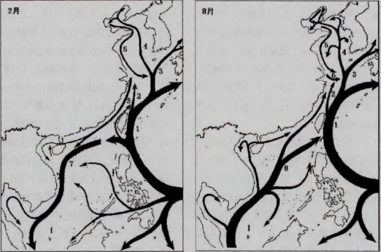
From the “Schematic diagram of ocean current system in China’s coastal waters”, it can been seen clearly that many ocean currents pass through or pass around the Zhoushan Archipelago, which plays an important role in the formation of the Zhoushan Archipelago’s sea routes. Many important shipping routes have been formed in the Zhoushan Archipelago since ancient times. However, there are not many specific records in the literature about the specific routes for sailing at that time. The specific research on the sea routes passing through the Zhoushan Archipelago is also insufficient in the academic circles. Except for the detailed studies of the sea routes of the Zhoushan Archipelago and nearby waters in the Northern Song Dynasty’s The Illustrated Report on the Diplomatic Mission to Goryeo in the Xuanhe Era (宣和奉使高丽图经) (Xia, 2018), there are few studies specifically on the Zhoushan Archipelago. Therefore, this article attempts to find out the relatively complete routes recorded in relevant historical literature so as to have a better understanding of the ancient sea routes of the Zhoushan Archipelago.
The sea route chart of Xu Fu’s voyage to Japan
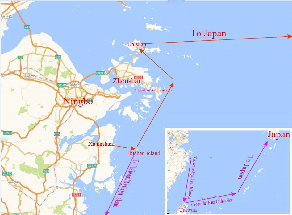
Regarding Xufu (徐福), or Xu Shi, a Chinese alchemist and explorer, there are many studies in the academic circles about records of his travel to sea to seek the elixir of life from immortals. One of the focuses is the departure place in China when Xu Fu left for Japan. According to the latest research results, some scholars believe that it is from Xiangshan (象山), via the Zhoushan Archipelago, Zhejiang, that Xu Fu set sail for Japan (He & Yang, 2018). However, few scholars have discussed Xu Fu’s specific route through the Zhoushan Archipelago in detail, so the paper makes an attempt to address this issue.
According to The Records of the Grand Historian (史记) (Sima, 1959: 247), in the twenty-eighth year of Qin Dynasty (219 BC), Chinese emperor Qin Shihuang (秦始皇) sent Xu Fu to travel eastward to seek the elixir of life from immortals at seas:
Xu Shi, a native of Qi (齐), wrote a letter saying that at seas there are three sacred mountains, named Penglai (蓬莱), Fangzhang(方丈), and Yingzhou (瀛洲), where immortals live. Practice fast and retrieve the elixir of life from the immortals with virgin boys and girls, so Xu Shi is sent with thousands of boys and girls to find immortals at sea.
There are many speculations about the location of the “three sacred mountains”. Some scholars believe that it is Daishan (岱山) in Zhoushan nowadays (Weng, 2016). Si Ming Tu Jing (四明图经), the oldest local chronicle in the eastern Zhejiang recorded, “Penglai Mountain is 450 li1 northeast of Changguo (昌国) County, surrounded by oceans. It is said that Qin Shihuang sent alchemist Xu Fu into the sea to seek the immortals and elixir. He once managed to arrive here.” (Zhang, 2007: 2). Emperor Lizong of the Southern Song Dynasty also referred to Daishan in Ying Gan Miao Feng Ling Ji Hou Zhi (英感庙封灵济侯敕), an edict issued in the ninth year of Chunyou (1249): “I heard that the sacred mountain on the sea is hazy and misty, and it is a place for spirituals. Changguo faces Penglai, and Daishan is also an unusual island.” (Tang, 2007: 449) Afterward, local chronicles of Zhejiang called Daishan Island “Penglai”. This has been confirmed in written records in the earlier time when the Epitaph of Madam Cheng of the Tang Dynasty was unearthed on Qushan (衢山) Island in Zhoushan in 1908:“(Madam. Cheng) was buried in Goushan, Penglai Town, Mao County (鄮县), Mingzhou Prefecture (明州) on the 25th day of the □□month of the year of □□” (Lou, 2017). In the view of people in the Tang Dynasty, Penglai refers to the entire Zhoushan Archipelago or Daishan Island, and “Goushan” clearly refers to the present “Qushan” of Daishan.
Dongfang Shuo (东方朔) (about BC161–BC93?), a famous writer, who was born a few decades later than Xu Fu, described the location of Yingzhou in his The Story of Ten Continents in the Sea (海内十洲记): “Yingzhou is in the East China Sea, four thousand li away, and it is probably opposite Kuaiji (会稽), and it is seven hundred thousand li to the west bank (Dongfang, 2000: 214).” It is pointed out definitely here that the location of Yingzhou is opposite to Kuaiji (present-day Shaoxing), 700,000 li away from the west bank. The opposite island of Kuaiji is the Zhoushan Archipelago, far away from the mainland of Shaoxing. “Dinghai Chronicle” (定海志) recorded: “It is said to be the present Daishan (Shi, et al., 2021: 246).”
Later Xu Fu did not return to the mainland. The Records of the Grand Historian also recorded Xu Fu’s whereabouts very clearly, saying that he came to a place with “flat plains and wide swamps” (平原廣澤) and proclaimed himself king, never to return (Sima, 1959: 3086). The records did not mention the exact location of “Pingyuan Guangze”, and it is generally believed in academic circles that Xu Fu did arrive in Japan. So, how did Xu Fu arrive in Japan? Scholars He Guowei and Yang Xuefeng had a detailed study regarding this issue. They believed that the place for Xu Fu’ retreat from the Qin Dynasty (秦朝) and departure before his eastward journey to Japan was Xiangshan in Ningbo, Zhejiang. The specific route is that his fleet departs from Xiangshan, and first arrives at Jiushan (韭山) Island in the east. Affected by the coastal current from north to south, the fleet then drifts south to the mainland coast that is closer to the north of Taiwan or the Ryukyu Islands, and then turns east and crosses the East China Sea. When entering the inner side of the outer island arc of the mainland, the fleet can go northward with the help of the warm current from southwest to northeast, passing through different islands before reaching Japan.
Judging from the current system in China’s coastal waters introduced at the beginning, this route is justified, that is, to use the coastal current of the Yellow Sea to drift south to the north of Taiwan or the Ryukyu Islands, and then to use the Kuroshio Current or the Tsushima Warm Current to go north along islands to Japan. However, a careful examination of charts will lead to the fact that this route has a large circle to the south, which is actually less convenient and economic. If the present Daishan was Penglai (or one part) at that time, and Xu Fu might have reached the shore at the mouth of Dongsha (东沙) Headland in the northeast of Daishan. Therefore, it is highly likely that there is another route for Xu Fu’s voyage to Japan, that is, to start from Xiangshan to the Jiushan Islands, and turn northeast, and then turn west and disembark at the mouth of Dongsha (东沙) Headland in the northeast of Daishan, and finally arrive in Japan with the help of the Kuroshio Current or the Tsushima Warm Current.
Based on the above analysis, we can describe in a more detailed and specific way the sea route of Xufu’ eastern voyage to Japan, which can ben shown in the figure below (Fig. 2).
The sea route charts of Jianzhen’s voyage across the East China Sea to Japan via the Zhoushan Archipelago
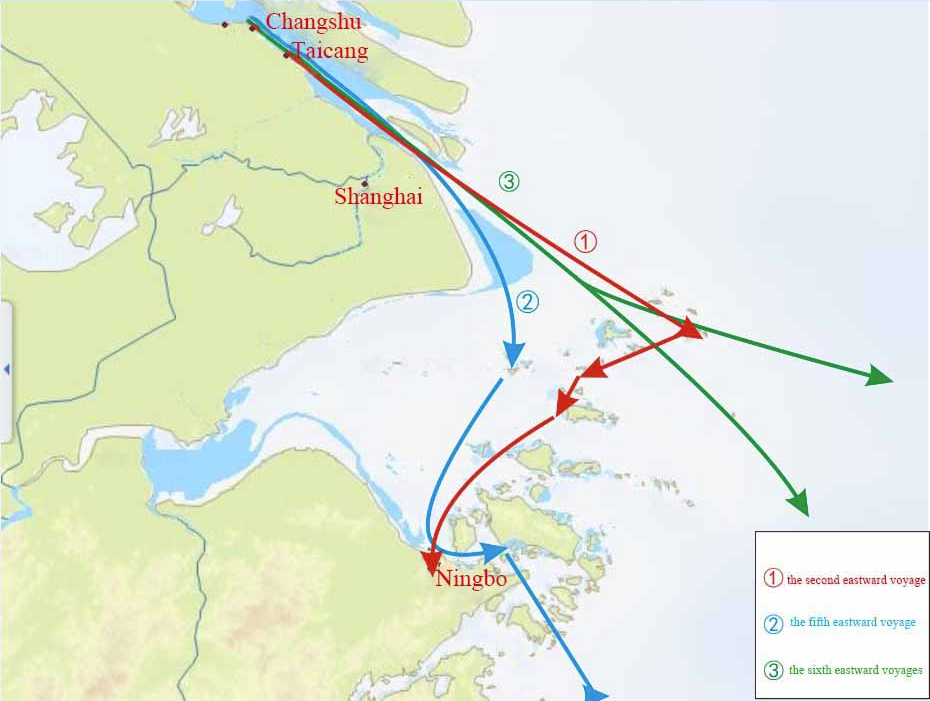
Jianzhen (鉴真) (688–763) was a famous Chinese monk, whose eastward voyages to Japan to spread Buddhism is of great significance in the history of Sino-Japanese cultural exchanges. In the eleven years from 743 to 754, Jianzhen attempted to visit Japan some six times, three of which are related to the Zhoushan Archipelago, namely the second, fifth and sixth visits (Wang, 2017:53–56).
According to The Great Master of the Tang Travels East (唐大和上东征传), Jianzhen’s first eastward journey occurred in Yangzhou (扬州) in the winter of the first year of Tianbao of Tang Dynasty (742), but it failed due to his disciples’ denunciation during the preparation process of shipbuilding (Zhenren, 2000:43–46).
Jianzhen embarked on his second eastern voyage to Japan in December of the second year of Tianbao (743), and he again set out from Yangzhou, accompanied by a total of more than 100 people aboard, among whom 17 monks, including Seng Xiangyan (僧祥彦), Daoxing (道兴), Deqing (德清), Rongrui (荣睿), Puzhao (普照)and Situo (思托), and 85 craftsmen, including jade creators, painters, sandalwood carvers, engravers, casting writers, embroiderers, text repairers, and stele engravers.
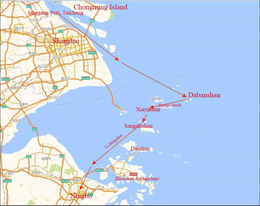
In the twelfth month of the second year of Tianbao (743) they set sail for the East. When they came to Langgoupu (狼沟浦), they met with adverse winds and high waves and the boat was damaged by the attacking breakers. Everybody went ashore, wading up to their waists in the tide. The Great Master was lifted on a reed stack while the others made their way through the water. With the cold winter winds blowing fiercely, [all this] was extremely excruciating. They repaired the boat and went on to Dabanshan [Island] (大坂山), but could not moor the boat there so they continued on to Xiayushan [Island] (下屿山), where they stayed for a month, waiting for good winds. Finally they set sail for Sangshishan [Island] (桑石山) , but because of the strong wind and high waves, the ship could not reach the shore, however hard they tried. In one moment they were swept away from the steep shore, in the next they were thrown back on the rocks again. The boat was damaged and men and ship went ashore. Lacking both rice and water, they suffered from hunger and thirst for three days. When the wind and waves were calm again, some fishermen came to their rescue and brought them water and rice. After another five days had passed, an official on his way back to [Zhen]hai came by and inquired about their situation. They petitioned the Prefect of Mingzhou Prefecture(明州) to provide accommodation, and they were lodged in the Aśoka (阿育王) temple on a mountain in the Mao County(郧县) (Zhenren, 2000:52–53).
During this trip, Jianzhen and his party encountered strong wind and waves, and suffered shipwreck in Langgoupu (present Langgang狼港Port near Liuhekou 浏河口 Estuary, Taicang 太仓) before going to sea. After the boat was repaired, they left the Yangtze River Estuary and arrived at Dabanshan (大板山) (present Dapanshan大盘山 Island, Shengshan 嵊山 Town, Shengsi 嵊泗 County of Zhoushan), but was unable to reach the shore due to winds and waves, and then transferred to Xiayushan (present Xiachuanshan 下川山 Island, Qushan衢山 Town, Daishan County of Zhoushan) to shelter from the wind for one month. Afterwards, Jianzhen’s ship ran aground on a reef while turning to Sangshishan (present Shuangzishan 双子山 Island, Qushan Town, Daishan County), and was taken by local fishermen to the Mingzhou government for resettlement. Although Jianzhen’s second eastward voyage failed again, we can clearly draw a sea route chart for this second eastward voyage in the Zhoushan Archipelago (Fig. 3).
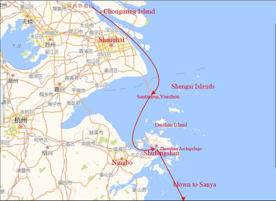
In the spring of the seventh year of Tianbao (748), Japanese monks Ryōei and Fushō once again invited Jianzhen to cross the East China Sea to Japan. On twenty-seventh of the sixth month, Jianzhen led 35 people, including monks, laymen and sailors to set off from Yangzhou for the fifth eastern voyage.
On the seventeenth of the sixth month they left the Chongfu (崇福) Temple and went to Yangzhou’s Xinhe (新河). They went aboard, [and travelled eastward until] they came to Langshan (狼山) on the border to Changzhou Prefecture (常州). There the wind became fierce and the waves high, and they were swept hither and thither between the three mountains. The next day they got a [favorable] wind and reached Santashan (三塔山) Island on the border to Yuezhou Prefecture (越州). There they stayed one month.
In the morning of the sixteenth day of the tenth month,… After a short while the wind rose and they departed, orienting themselves by the mountains along the coast. In the Southeast they saw a mountain, but at noon it was gone and they realized that it was a mirage.
[All] this was in winter, in the eleventh month, but the trees were in full bloom and [some] were bearing fruit and the bamboo was sprouting, it was just like in summer. After spending [another] fourteen days on sea they finally arrived at a shore. They dispatched a few men to look for a place to moor the boat. [They met] four travelling merchants, who showed them the way and left. These four said, “It is because of the Great Master’s [good] karma, that you have met us. In this place, there are cannibals. You should leave immediately!” After that [the seamen] pulled the boat into a small natural harbour.
In the evening there came a man with long, unkempt hair, carrying a knife. All were very scared. They gave him some food and he went away.
They left [the same] night and three days passed [on the sea]. Finally they anchored in the delta of a river in Zhenzhou Prefecture (振州)... (Zhenren, 2000:62–67).
During the fifth voyage, when Jianzhen and his party sailed near Langshan (present Langshan Port, Nantong City, Jiangsu Province) on the boarder of Changzhou Prefecture they saw strong winds and high waves on the surface of the Yangtze River, and the river water revolved around the three islands of Langshan and they rested in a boat nearby. The next day, Jianzhen and his entourage saw that the wind was favorable, so they sailed along the coastline to Santashan in Yuezhou (present Xiaoyangshan 小洋山, Shengsi County, Zhoushan) to rest for a month, and then sailed out of Hangzhou Bay to Shufengshan (暑风山present Xiaofengshan 晓峰山, Dinghai District, Zhoushan City) in the Zhoushan Archipelago. After mooring for a month to rest, on the 16th day of the tenth month, taking the highest peak of the Zhoushan Archipelago in the southeast direction, Ding’anshan (顶岸山) (now Duozhishan 对峙山, Taohua Island, Putuo District, Zhoushan City) as a reference, the ship departed from Xiaofengshan and sailed southeast, intending to turn eastward to Ding’anshan (present Zhushan 珠山 or Zhuyanshann 珠岩山, Xiangshan County, Ningbo, or Zhujiajian (朱家尖) in the south of Putuo Mountain of Zhoushan). During the voyage, the ship encountered strong winds and raging waves, and was blown by the wind and drifted to Zhenzhou on Hainan Island (present Sanya, Hainan). Jianzhen’s fifth eastward voyage departed from Chongfu Temple in Yangzhou, and it still failed after several months. However, the sea route for this eastward voyage via the Zhoushan Archipelago can still be clearly marked in the following chart (Fig. 4).
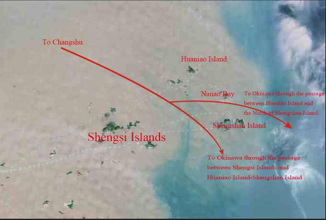
In the twelfth year of Tianbao (753), Jianzhen, who was then blind, together with the Japanese monk Fushō, led an entourage of 24 people to Japan with a large number of scriptures. After going through various obstacles and hardships, they finally boarded in Huangsipu (黄泗浦) (present Huangsi黄泗, Changshu) ships of the 12th Japanese mission to Tang Dynasty which was on the return journey to Japan. Among them, Ambassador Fujiwara Kiyokawa and Abe Nakamaro took the No.1 ship, and Jianzhen took the No. 2 ship. On the twenty-first day of the eleven month of the twelfth year of Tianbao, ships No. 1 and No. 2 met the third ship in Okinawa (Zhenren, 2000:85–91). It can be seen clearly that Jianzhen’s eastward journey undoubtedly passed through the Zhoushan Archipelago, but the specific route of his journey through the Zhoushan Archipelago was not clearly stated, so it is impossible to know. However, judging from the route of the fleet sailing southeast in a straight line from Huangsipu to Okinawa Island, there are almost only two possibilities for Jianzhen and his party to pass through the Zhoushan Archipelago. One is between Shengsi Islands and Huaniao (花鸟) Island-Shengshan Island, and the other is between Huaniao Island and the north of Shengshan Island. The detailed map can been seen as below (Fig. 5).
If we combine the sea routes of the Zhoushan Archipelago for Jianzhen’s second, fifth, and sixth eastward crossings on one map, we can obtain the following diagram (Fig. 6).
The sea routes of the Zhoushan Archipelago in Xu Jing’s Illustrated Report on the Diplomatic Mission to Goryeo in the Xuanhe Era
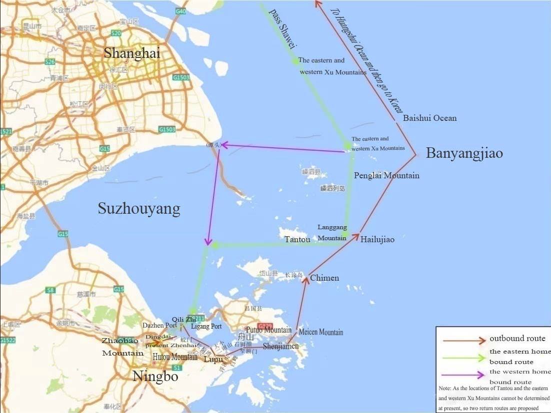
In the fifth year of Xuanhe (宣和) in the Northern Song Dynasty (1123), Emperor Huizong (徽宗) of Song Dynasty sent two officials Yun Di (允迪) and Fu Moqing (傅墨卿) as envoys to Korea from Mingzhou. In the sixth year of Xuanhe (1124), Xu Jing (徐兢), the clerk of the mission, completed The Illustrated Report on the Diplomatic Mission to Goryeo in the Xuanhe Era (宣和奉使高丽图经) in 40 volumes, making it the earliest official document describing the voyage experience in Chinese. This document records in detail more than 40 sea routes from Mingzhou to Goryeo, and records the water conditions along the routes, which is of great significance for us to understand the sea routes of the ancient Zhoushan Archipelago. Relying on this document, we can clearly find out the detailed information of the sea routes of the Zhoushan Archipelago at that time.
The routes mentioned in The Illustrated Report on the Diplomatic Mission to Goryeo in the Xuanhe Era are generally regarded as “Xu Jing’s Sea Routes”. In Volume 34 and Volume 39, the trips to and from the Mingzhou are recorded respectively, and the maritime route of “Xu Jing’s Sea Route” passing through the Zhoushan Archipelago and the nearby waters are studied. Scholar Xia Zhigang in his paper “Textual research on Mingzhou Section of Xu Jing’ s Sea Routes” has closely examined the Mingzhou section of the “Xu Jing’s sea route”.2 He divided it into two parts, namely the outbound ward journey and the homebound journey. The outbound journey was further divided into seven sections: (1) Zhaobao Mountain (招宝山)-Qilishan (七里山); (2) Qilishan (七里山)-Lupu (芦浦); (3) Lupu (芦浦)-Shenjiamen (沈家门); (4) Shenjiamen (沈家门)-Putuo Mountain (普陀山); (5) Putuo Mountain (普陀山)-Hailujiao (海驴焦); (6) Hailujiao (海驴焦)-Penglai Mountain (蓬莱山); (7) Penglai Mountain (蓬莱山)- Banyangjiao (半洋焦). For each section of the specific route, Xia has detailed descriptions in his article by means of maps, so this will not be repeated.
The description of the homebound journey of “Xu Jing’s seat routes” is very brief and is interpreted as follows, with the traditional Chinese time keeping changed into the modern way:
At xinchou (辛丑) (1–3 o’clock in the morning) of the twenty-first day, we crossed Shawei (沙尾). At noon, the second boat’s three mates broke down, and four quarters later in the night (夜漏下四刻), the main one also broke down, so that this boat and the others were in danger. At renyin (壬寅) (3–5 o’clock in the morning) of the twenty-third day, we saw Xiuzhoushan (秀州山) of China. At guimao (癸卯) (5–7 o’clock in the morning) of the twenty-fourth day, we passed the eastern and western Xu Mountains (胥山). At jiachen (甲辰) (7–9 o’clock in the morning) of the twenty-fifth day, we entered Langgangshan (浪港山) and passed Tantou (潭头). At yisi (乙巳) (9–11 o’clock in the morning) of the twenty-sixth day, we crossed the Suzhou Ocean (苏州洋), and at night birthed at Ligang (栗港). On Bingwu (丙午) (11–13 o’clock) of the twenty-seventh day, we passed Jiaomen (蛟门) and could see Zhaobaoshan (招宝山), and arrived at Dinghai (定海) County at noon (午刻). From Koryo to the border of Mingzhou, it took 42 days by sea (Xu, 1985:135).
The place names in this record, such as the eastern and western Xu Mountains and Tantou, are difficult to find their present corresponding landmarks. Xia justified the rationality of the eastern and western routes and drew them on the maps. However, Xia did not describe the overall routes of the “Xu Jing’s sea route” on the map. Therefore, based on Xia’s segmented chart description, the sea routes of the Zhoushan Archipelago for the Diplomatic Mission to Goryeo in the Xuanhe Era could be summarized and illustrated as follows (Fig. 7).
The needle sea routes to Japan via the Zhoushan Archipelago in the Ming Dynasty
Navigation texts dating from the Ming Dynasty in China use a 24-pointed compass with named directions. The direction of navigation determined by the compass needle (针 Zhen) is called “Zhenwei” (针位 the needle position), and the trajectory traveled along the needle position is called “Zhenlu”(针路 the needle sea routes). “Zhenjing” (the needle records) is the abbreviation of “Haidao Zhejing” (海道针经, sea routes and needle records). Historically, there have been more and more sea routes, just like roads on land. People could follow the sea routes, so they began to call them “Haidao” (海道 sea routes). After the invention of the nautical compass, the needle position and trajectory of the sea routes were recorded in books, which can be used for navigation. This kind of books was called “Zhenjing”. In general, “Haidao Zhenjing” is what is called “navigation guide” today.
This could help us to understand the literature about the needle sea routes in the Ming Dynasty, a dynasty when Ningbo was designated as the only port that could carry out overseas trade with Japan because of the overseas trade policy of the Ming government. Therefore, Japanese ships to China had to go to Ningbo for trade. During the Ming Dynasty, the coastal areas of China were also harassed by Japanese pirates for a long time, which greatly hindered the exchanges between China and Japan, and even the normal maritime traffic between China and Japan was seriously damaged. However, the maritime trade between China and Japan has never stopping developing.
During the reign of Emperor Jiajing (嘉靖) in the Ming Dynasty, Wu Pu (吴朴) of Zhangzhou (漳州) in Fujian Province had a thorough study of all known sea routes and wrote a book entitled Equation for Crossing the Seas (渡海方程). The book has been missing, but Zheng Kaiyang’s Miscellany (郑开阳杂著) and A Compilation of Nautical Charts (筹海图编) compiled by Zheng Ruozeng (郑若曾), and A Guide to Japan (日本一鉴) by Zheng Shungong (郑舜功) recorded two needle sea routes between China and Japan, based on Equation for Crossing the Seas, The Needle Sea Routes Records (海道针经) and Guide to the Four Seas (四海指南). One was the route from Taicang to Japan and the other from Fujian to Japan. These two needle sea routes to Japan were newly- started in the Ming Dynasty, of which, the route from Taicang to Japan covered the sea routes in the Zhoushan Archipelago.
The original records could be found in Zheng Ruoceng’s records (Zheng, 1986:549–550), but was written in the traditional Chinese ways to record sailing directions, sailing distances and time, the depth of soundings and the names of the places.
Firstly, the compass used for navigation direction in the Ming Dynasty was the 24-pointed compass (Fig. 8). This technique uses the 4 cardinal directions, 8 heavenly stems and 12 earthly branches. When a single direction is specified, it may be prefaced by the character “單” or “丹” (meaning single). Headings mid-way in-between are compounds as in English. For instance, “癸子” refers to the direction halfway between needle 子 and needle 癸, or 7.5°.
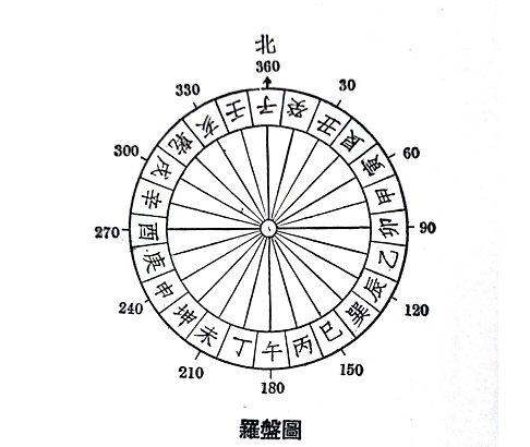
The relationship between the name of the needle, the directions and the angles can be illustrated in the following ways (Table 1).
| Needle Point | Ordinal Name | Angle | Needle Point | Ordinal Name | Angle | Needle Point | Ordinal Name | Angle | Needle Point | Ordinal Name | Angle |
|---|---|---|---|---|---|---|---|---|---|---|---|
| 子 zǐ | north | 0° or 360° | 卯 mǎo | east | 90° | 午 wǔ | south | 180° | 酉 yǒu | west | 270° |
| 癸 guǐ | 15° | 乙 yǐ | 105° | 丁 dīng | 195° | 辛 xīn | 285° | ||||
| 丑 chǒu | 30° | 辰 chén | 120° | 未 wèi | 210° | 戌 xū | 300° | ||||
| 艮 gěn | northeast | 45° | 巽 xùn | southeast | 135° | 坤 kūn | southwest | 225° | 乾 qián | northwest | 315° |
| 寅 yín | 60° | 巳 sì | 150° | 申 shēn | 240° | 亥 hài | 330° | ||||
| 甲 jiǎ | 75° | 丙 bǐng | 165° | 庚 gēng | 255° | 壬 rén | 345° |
Secondly, sailing time or distance, which takes account of the local currents and winds, is expressed in Chinese units of time “geng” (更), which is equivalent to 2.4 hours. The “geng” is also a unit of distance, usually about 16.2 nautical miles, or about 30 kilometers (60 li, or Chinese miles).
Thirdly, sometimes the depth of soundings are also provided in the needle records. “Dashui” (打水, which literally means to beat the water) means to measure the depth of soundings. The unit for the depth of soundings is tuo (托). One tuo is equivalent to about 1.68 meters (Xiang, 2000:6–7).
Fourthly, the location of all places are recorded in a historical way, which can be identified, if possible, as the present names.
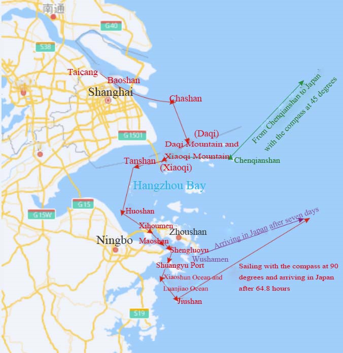
Based on these knowledge, Zheng Ruoceng’s original records could be interpreted and understood as follows.
Sail from Taicang (太仓) Port with the compass in the direction of 105 degrees, it takes about 2.4 hours to arrive at Wusong (吴淞) River; sail from Wusong River with the compass in the direction of 105 degrees and 97.5 degrees, it takes about 2.4 hours to reach Baoshan (宝山); from Baoshan to Nanhizui (南汇嘴) sail with the compass at 112.5 degrees, and it takes about 7.2 hours to arrive at Chashan (茶山) (present Sheshan 佘山 Island, Chongming District, Shanghai); from Chashan, sail with the compass at 232.5 degrees and 202.5 degrees, and it takes about 7.2 hours to arrive at Daqi Mountain and Xiaoqi Moutian (大小七山) (present Dajishan大戢山 and Xiaojishan 小戢山, Yangshan Town, Shengsi County). From Tanshan (滩山) (now Tanhushan (滩浒山) Island in Wangpanyang, Yangshan Town, Shengsi County) sail with the compass in the direction of 195 degrees and 187.5 degrees, it takes about 7.2 hours to reach Huoshan (霍山) (now Xihuoshan Island of the Seven Sisters and Eight Sisters Islands in Daishan County); start from Huoshan and sail with the compass in the direction of 180 degrees to enter Xihoumen (西堠门) (now Xihoumen Waterway in Dinghai District); sail with the compass in the direction of 142.5 degrees, and arrive at Maoshan (茅山) (now Damaoshan 大猫山, Dinghai District) after 7.2 hours. Start from Maoshan, proceed in the direction of Yichen Needle,3 and arrive at Miaozhoumen (庙州门, the exact location can not be identified); pass through Miaozhoumen and arrive at Shengluoyu (升罗屿) (the outermost corner of the Chuanshan (穿山) Peninsula, that is Outer Qitou (岐头), north of Meishan); start from Shengluoyu and travel with the compass in the direction of 202.5 degrees, pass Qitou Mountain, and arrive at Shuangyu Port (双屿港, present Zhangqi Port, Zhonglv Bay and nearby bays in Liuheng Town, Putuo District, Zhoushan); from Shuangyu Port travel with the compass at 172.5 degrees, and arrive at the Xiaoshun Ocean (孝顺洋) and Luanjiao Ocean (乱礁洋) between Liuheng and Xiangshan after 7.2 hours. From Jiushan (九山) (Jiushan Islands (韭山列岛)), travel with the compass in the direction of 90 degrees, cross the ocean and arrive the port of Japan after 64.8 hours.
Or, one can also set out from Wushamen (乌沙门) (South of Zhujiajian) and arrive in Japan in seven days.
If one travels from Chenqianshan (陈钱山) (present Shengshan) to Japan, sail with the compass in the direction of 45 degrees.
The first is the needle sea route from Taicang, Jiangsu Province to the south via the Zhoushan Archipelago, and then to the Jiushan Islands and finally to Japan. The latter two needle sea routes are not separate, but the turning point of the needle position in the needle sea routes is different, resulting in departure from two different harbors, so it can be integrated into the Taicang needle sea route. This needle sea route is only said to be “to Japan”, but judging from the traditional sea route, this needle sea route may sail to Japan’s Goto Islands and then to Hakata (博多), which are part of the traditional sea route (Liu, 2019, 123). According to the above description, we can describe them in detail on the chart as follows (Fig. 9).
The sea routes of Zhoushan Archipelago for Zheng He’s Expeditions to the Western Ocean
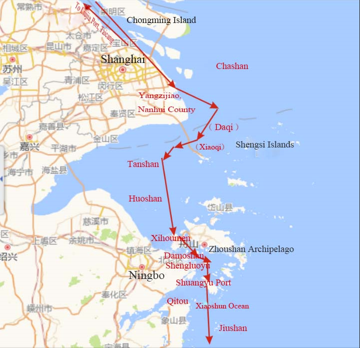
Zheng He’s Expeditions to the Western Ocean is a great feat in the history of the world navigation. During his expeditions, Zheng He used simple surveying, mapping and Chinese landscape painting to describe the features along the navigation and drew a chart called “Sailings of the Treasure Ships from Departing at Longjiang Pass to Arriving at Foreign Countries” (自宝船厂开船从龙江关出水直抵外国诸番图). In the past, people thought this name was too long to remember, so it was shortened to “Zheng He’s Navigation Chart” (郑和航海图). The original chart consists of a total of 24 pages: one page of the preface, 20 pages of the charts, two pages (four pieces) of “Stars Map Crossing the Ocean”(过洋牵星图), and one blank page. It is contained in the 240th volume of The Wubei Zhi (武备志, A Treatise on Armament Technology Treatise on Armament Technology or Records of Armaments and Military Provision) (Mao, 2002:319–330). The preface has only 142 characters, and it is assumed to be written and compiled by the author of the chart Mao Yuanyi (茅元仪1594–1640?), a native of Gui’an (归安)(now Huzhou City) in Zhejiang Province in the Ming Dynasty. The chart probably shows Zheng He’s last voyage to the Western Ocean in the fifth year of Xuande (1430) under the reign of the Emperor Xuanzong Zhu Zhanji (朱瞻基). The voyage and geography on the chart are consistent with a voyage in Xuande Era which was recorded in Previous Records (前闻记) by Zhu Yunming (祝允明). Therefore, the nautical chart in The Wubei Zhi can be assumed to have been handed down in the middle of the fifteenth century (Xiang Da, 2002:4). All the nautical charts are in the book style (it was originally a hand scroll style, but it was changed to a book style after it was included in The Wu Bei Zhi, so it is drawn in a horizontal style from right to left). After leaving the mouth of the Yangtze River, the treasure ships headed south along the coasts of Jiangsu, Zhejiang, Fujian, and Guangdong. This part is understandable. Only the section from Nanjing to the Yangtze River Estuary runs from west to east, because in order to match the sections below the Yangtze River Estuary, the directions from Nanjing to the Yangtze River Estuary are reversed on the chart when drawn and hence the south bank becomes up south and down north. The maps is drawn by this method all the way to the mouth of the Yangtze River, until after the fleet exited the mouth of the Yangtze River, the normal position is restored.
The section from the then Imperial City (Nanjing) to the port of Taicang does not indicate the sea route by the pointed compass system, but the bridges, rivers, ports, mountains, trees, islands, sandbanks, city walls, important buildings, patrol stations (posts) on both sides of the section are described according to the order of the voyage and the distance of the route. From Baoshan to the port of Taicang (Liujia Port 刘家港), the chart not only shows the location and the route along the way, but also describes the navigation in words by the compass needle system. The sailing instructions for both the outbound and homeward voyages between Jiangsu to Zhejiang are given by the means of China’s pointed compass system.4
According to the illustrations and needle records, the route of the treasure ship to the southern waters of the Zhoushan Archipelago is as follows with the traditional Chinese ways to record sailing directions, sailing distances and time, the depth of soundings and the names of the places interpreted in modern ways.
The outbound voyage:
[the treasure ships] headed towards Baoshan (宝山), traveled from NNW west to West, with a heading of 277.5 degrees and a journey of 180 li (or 7.2 hours), and sailed across the Wusong (吴淞) River and arrived at Liujiagang (刘家港), Taicang. Set sail from Liujiagang, Taicang, and travel SSE with a heading of 105 degrees and a journey of 60 li (or 2.4 hours), and the hull was level with the Wusong River. The treasure ships continued to advance from the Wusong River and travelled from SSE to east, with a heading of 97.5 degrees and a journey of 60 li (or 2.4 hours) to arrive at Yangzijiao (杨子角), Nanhui County, and then the treasure ship sails parallelled to Zhaobaoshan (招宝山), Zhenhai, Zhejiang. The treasure ships sailed from SSE to ESE again with a heading of 112.5 degrees and a journey of 180 li (or 7.2 hours). The treasure ships sailed away from the steep rapids of the waterway, and the depth was measured at 1 zhang 6 chi to1 zhang 7 chi5, indicating that the treasure ship was on a normal navigation path. The treasure ships continued to move forward, and saw Chanshan passing by in the northeast. The treasure ships then sailed from southeast to SSE, with the heading of 142.5 degrees and a journey of 240 li (or 9.6 hours) and could have a glimpse of Xiaoqi Mountain and Daqi Mountain (大小七山) (today’s Daji Mountain 大戢山 and Xiaoji Mountain 小戢山, both of which were located in the west of the Shengsi Islands in Zhejiang Province), and the measured water depth was six or seven tuo (between 3 zhang 6 chi and 4 zhang 2 chi). The treasure ships travelled from southwest to WSW, with a heading of 232.5 degrees; then travelled from south to west to southwest, with a heading of 202.5 degrees; after a journey of 180 li (or 7.2 hours) approached towards Tanshan (滩山) (Tanhushan 滩浒山 Island, Zhoushan). The treasure ships continued to sail south, with a heading of 180 degrees and a journey of 180 li (or 7.2 hours), and headed towards Huoshan (霍山) (now East Fushan Island 东福山岛). The heading remained unchanged, and headed south into the Xihoumen (西后门) (now Xihoumen 西堠门); then headed from southeast to SSE, with a heading of 142.5 degrees and a journey of 180 li (or 7.2 hours), and sailed towards Damoshan (大磨山) (now Damaoshan 大猫山 Island). The treasure ships travelled from ESE to east, with a heading of 112.5 degrees and a journey of 60 li (or 2.4 hours), and sailed towards Xiaomoshan (小磨山) (now Xiaomaoshan 小猫山 Island), and then turned to Qitou (now north of Xiangshan Port, east of Chuanshan, known also as Qitou Promontory) and Shengluoyu (the outermost corner of Chuanshan Peninsula, outside of Qitou, north of Meishan 梅山). Sail from SSW to south, with a heading of 202.5 degrees and a journey of 60 li (or 2.4 hours of sailing), and sail out of Shuangyu (双屿) Port (now Zhangqi 涨起 Port, Zonglv 棕榈 Bay and the vicinity of Liuheng Town, Putuo District, Zhoushan. Travel from SSE to south, with a heading of 172.5 degrees and a journey of 60 li (or 2.4 hours), and head towards Xiaoshun (孝顺) Ocean (between Liuheng and Xiangshan), and the water depth measured along the way was 9 tuo (5 zhang and 4 chi). Sail along Jiushan (now Jiushan Islands) and keep a parallel distance with it. Facing the southwest of Jiushan, there was a sunken reef hit by wind and waves, and it emerged from the water from time to time, so be careful when sailing. Then, the treasure ships sailed from south to north to WNW, with a heading of 292.5 degrees (or 277.5 degrees)6, and the ship travelled 120 li (or 4.8 hours). Sail near Tantoushan (檀头山) (in the northeast of Nantian Island, outside Sanmen Bay, Zhejiang Province) and then sailed parallel to it. There was a river reef in the east of the mountain, and Dafotou (大佛头) Mountain in the west (in the west of Tantoushan 檀头山 in Zhejiang Province, near Changguowei 昌国卫). The ships then sailed to the Eastern and Western Qishan (崎山) (120 li north of Dachenshan 大陈山 Island today). The treasure ships travelled from SSE to south, with a heading of 187.5 degrees and a journey of 300 li (or 12 hours) and passed Yangqishan (羊琪山) (south of Tantoushan 檀头山 and north of Dachen Island), Dachenshan 大陈山 (namely, Dachen Island, outside Taizhou Bay, south of Yijiangshan (一江山) Island), Sanmushan (三母山) (today’s Sanqishan 三歧山), and Huangjiaoshan (黄礁山) (south of Dachen Island), and then ahead one could see Zhigushan 直谷山 (west of Shitang 石塘 Island, Wenling) ahead. The treasure ship then headed south-west to southwest-south, with a heading of 202.5 degrees and a journey of 120 li (or 4.8 hours), and the ship sailed near Shitangshan (石塘山)…
The homebound route of the fleet is basically the same as the outbound voyage, which will not be repeated here.
According to this route, we can describe the route of the treasure ship through the Zhoushan Archipelago as shown in the figure below (Fig. 10).7
The sea routes of the Zhoushan Archipelago recorded in Qing Dynasty
Ancient navigators went back and forth in the vast and rough seas, and they had to be acquainted with the distance, direction, weather and climate at sea, currents, tides, depths of waterways, reefs, water depths in mooring places, and seabed conditions. Regarding the records of the mountains and waters during these voyages, it is not known whether there were professional navigation books before the Song and Yuan dynasties of China. In the Ming Dynasty, The Sea Route Records (海道经) collected in Jin Sheng Yu Zhen Ji (金声玉振集) records the situation of transporting grain from Nanjing to Tianjin by the sea routes. In the Qing Dynasty, Huang Shujing (黄叔璥) wrote in his book A Tour of Envoy in the Taiwan Strait (台海使槎录), “Every seaman has a secret copy of each ocean, called Yang Geng (洋更).” “Yang” is the ocean, and “Geng” is the measurement of sailing time and distance, so “Yang Geng” is the traditional navigation book in the ancient China. In addition, there were needle charts and compass books, which, like “Yang Geng”, were equivalent to today’s general book of navigation. The needle charts and compass books of the Ming and Qing Dynasties can be found in various references such as Equation for Crossing the Seas, Haidao Jingshu (海道经书), Guide to the Four Seas (四海指南), Secrets of Sea Navigation (海航秘诀), A Complete Book of Navigation (航海全书), Needle Spectrum (针谱), Navigation Needle Classic (航海针经), Needle Positions (针位篇), Compass Needle Book (罗经针簿) and so on (Xiang, 2000:2–3).
Guides and Rules (指南正法 Zhinan Zhengfa), which was attached to The Ancient Book of Soldiers (兵钤 Bingqian) and compiled by Lu Chengen (卢承恩) and Lu Pan (吕磻) in the early Qing Dynasty, was collected around the early 18th century in the late years of the reign of Emperor Kangxi. Guides and Rules contains roughly three parts. The first part is about meteorological observation methods, such as solar eclipse moments, lunar winds, tide fluctuations, thunder, lightning, star viewing, compass needles and the distance. The second part is the record of mountains and waters of each prefecture. There are a few brief sailing instructions along each route. In the third part, there were detailed records of the return needle sea routes, such as the sunrise, compass direction, distances, hidden reefs, water depth and whether anchorage were possible (Xiang, 2000:4–5).
Guides and Rules has different chapters with detailed descriptions of mountains and waters of the islands in the Eastern and Western Oceans. Among them, Mountains and Waters for Sailing in the East (𩫅8东山形水势) records in detail the conditions of the mountains, islands, and seas of the Zhoushan Archipelago and the surrounding sea areas, in particular the depth of soundings in the different places of the Zhoushan Archipelago (Xiang, 2000:114–115). These lays a good foundation for sailing in the Zhoushan Archipelago.
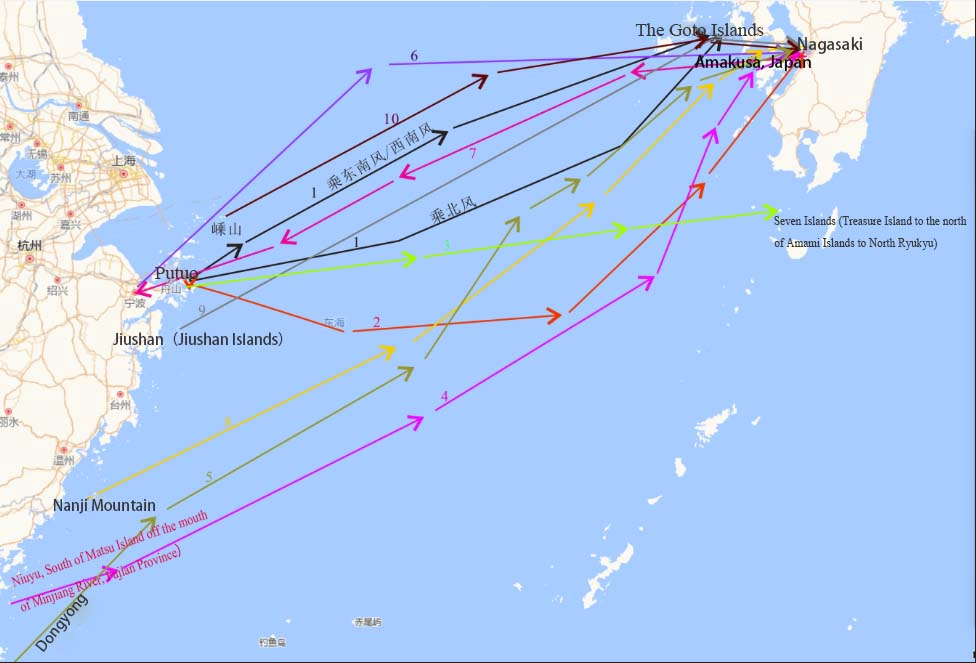
In Guides and Rules, the needle sea routes involving Zhoushan Archipelago mainly include those from Ningbo and Putuo to and from Japan. The specific routes are as follows.
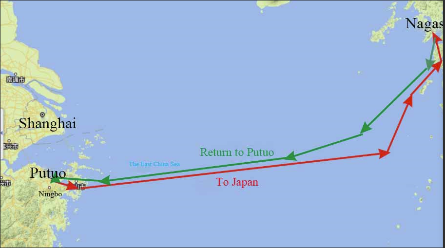
The needle sea routes from Ningbo to Japan:
Set sail from Putuo with the compass at 90 degrees, and after about 33.6 hours, sail with the compass at 90 degrees for 24 hours, and then sail with the compass at 67.5 degrees for 19.2 hours, and then navigate with the compass in the direction of 75 degrees for 19.2 hours to see Paradise (present Amakusa, Japan) and arrive at Nagasaki (Xiang, 2000:168–169).
The homebound voyage to Ningbo from Japan:
sail for 12 hours with the compass at 187.5 degrees to the Paradise, then sail for 31.2 hours with the compass at 247.5 degrees, then sail for 19.2 hours with the compass at 255 degrees, and then sail for 43.2 hours with the compass at 262.5 degrees, and then sail for 24 hours with the compass in the direction of 270 degrees to reach Putuo, that is Ningbo Port (Xiang, 2000:169).
Based on the above description and analysis, we can briefly draw a map of the navigation route between Ningbo (Putuo) and Nagasaki, Japan (Fig. 11).
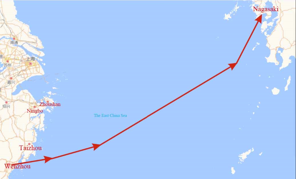
The needle sea route from Wenzhou to Japan (Nagasaki) is recorded as follows.
Sail from Wenzhou with the compass at 75 degrees, and after about 12 hours, sail with the compass at 67.5 degrees for 14.4 hours, then sail with the compass at 60 degrees for 48 hours, and then sail with the compass at 52.5 degrees for 36 hours to reach Japanese Mountain (Xiang, 2000:169).
According to the needle sea routes, the Japanese mountain in the original record probably refers to Nagasaki. Based on this description, the navigation route map from Wenzhou to Japan can be depicted as follows (Fig. 12).
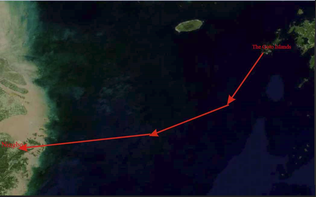
The needle sea route from Japan’s Goto Islands back to Ningbo (Putuo) is recorded as follows.
Sail from Japan’s Goto Islands with the compass at 232.5 degrees for 16.8 hours, then with the compass at 247.5 degrees for 36 hours, and then with the compass at 255 degrees and 262.5 degrees for 60 hours to reach Ningbo (Putuo) (Xiang, 2000:169).
Based on the aforementioned description, the voyage map for returning to Ningbo (Putuo) from Japan’s Goto Islands can be drawn as follows (Fig. 13).
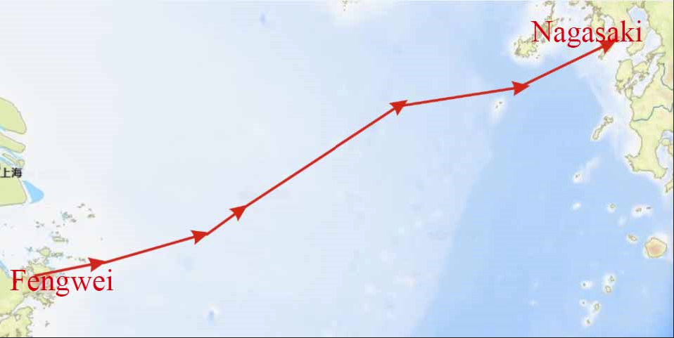
The needle sea route from Fengwei in Luanjiao Ocean in Dinghai to Nagasaki, Japan is as follows.
From Fengwei take the southwest wind and sail at 67.5 degrees for 12 hours, then at 60 degrees for 14.2 hours, at 37.5 degrees for 4.8 hours, and then sail in the direction of 37.5 degrees for 43.2 hours, and then sail in the direction of 60 degrees for 19.2 hours, you can see Lishenma (里慎马) outside Nagasaki Port, Japan, and then sail in the direction of 67.5 degrees for 16.8 hours to enter the Nagasaki Port (Xiang, 2000:175).
In this description, Fengwei is in the south of Dinghai, Zhoushan according to the maps in The Tales of the Sea Country (海国闻见录). Lishenma (里慎马) could be Lishenma (里甚马), which remains unknown, but could not be the Goto Islands as there are distinct differences in pronunciations.
According to this description, we can draw the navigation route from Fengwei to the Nagasaki Port as follows (Fig. 14).
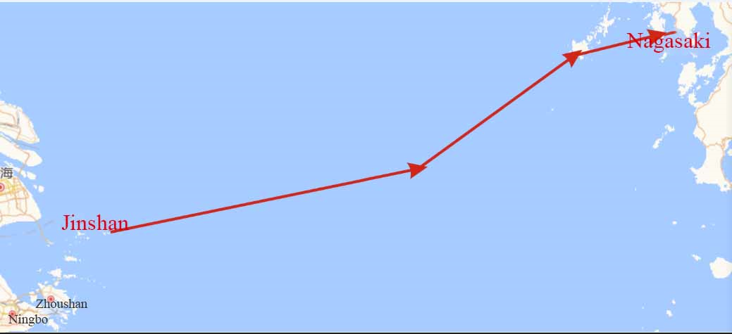
The sea route from Jinshan (尽山) (outside the mouth of the Yangtze River, also known as Chenqian 陈钱 Island, between Ma’anshan 马鞍山 Islands and Shengsi Islands), Zhoushan to Nagasaki, Japan, is as follows.
Leave the port on the north wind, and sail in the direction of 60 degrees for 36 hours and at 45 degrees for 21.6 hours to reach the Goto Islands. Then it takes 12 hours at 60 degrees to enter the Nagasaki Port. (Xiang, 2000:176)
According to the description, the navigation route from Jinshan to the Nagasaki Port can be drawn as follows.
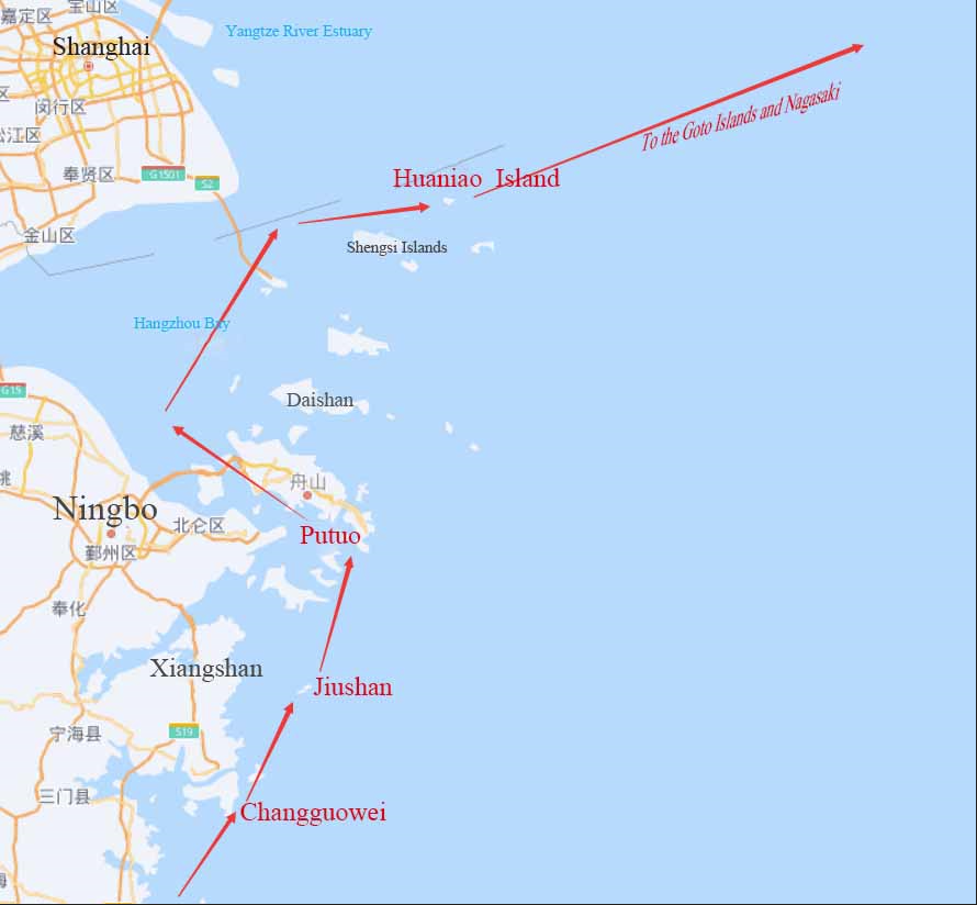
The description of the sea route from Shacheng (沙埕) (Shacheng Port, Fuding County, Fujian Province) to Nagasaki Port, Japan is interpreted as follows.
Starting from Shacheng, it takes 4.8 hours to arrive at Nansong (南松); from Nansong, it takes 4.8 hours to reach Beisong (北松); from Beisong, it takes 4.8 hours to Nanji (南𣏌) (Nanji Mountain 南麂山); from Nanji it takes 4.8 hours to reach Beiji (北𣏌) (Beiji Mountain 北麂山); from Beiji it takes 7.2 hours to Songmen (松门) (Songmen Island, Wenling, Zhejiang); it takes 7.2 hours from Songmen to Changguowei (昌国卫) (East of Sanmen 三门 Bay, Xiangshan); it takes 4.8 hours from Changguowei to Fengwei (凤尾); it takes 4.8 hours from Fengwei to Jiushan 九山 (Jiushan Islands 韭山列岛); it takes 4.8 hours from Jiushan to Beijigu (北积谷) (the exact location is not identified); it takes 7.2 hours from Beijigu to Putuo, where you can see Chashan 茶山 (Sheshan 佘山 Island, Chongming District, Shanghai) and Songjiang (松江) of Shanghai County. It takes 7.2 hours from Putuo to the northwest to Sitangao (思堂澳) (north of Putuo and south of Huaniao 花鸟 Island); 2.4 hours from Sitangao to Huaniao Island; 4.8 hours from Huaniao Island to Qingshan (青山) (the exact location is not identified), and then sail along the northwest wind in the direction of 90 degrees one can see Koryo (Korea); proceed in the direction of 127.5 degrees for 12 hours to the Goto Islands, and then sail in the direction of 60 degrees for 16.8 hours to reach Nagasaki Port (Xiang, 2000:176–177).
According to the aforementioned description, the navigation route from Shacheng to the Nagasaki Port in Japan is as follows (Fig. 16).
The navigation route from Nagasaki Port, Japan is descripted as follows.
Start from Putuo, if one takes the southeast or southwest wind, sail in the direction of 67.5 degrees; if you take the north wind, sail in the direction of 52.5 degrees, and go forward, one can see Lishenma (里甚马) after 76.8 hours, and arrive at the Goto Islands.
If you start from Putuo, take the south wind and sail in the direction of 120 degrees and 9.5 degrees for two days, and then travel in the direction of 82.5 degrees and 67.5 degrees.
If you start from the boundary of Ningbo (probably Putuo)9 and sail in a direction of 82.5 degrees for 110.4 hours, one can see Qidaoshan (七岛山) (Treasure Island to the north of Amami Islands in the North of Ryukyu) and Yegushan (野故山)10 (Nokoshima Island).
If you sail from Niuyu (牛屿) (South of Matsu Island outside the Minjiang Estuary in Fujian) to Nagasaki, you will arrive at Dongyong (东涌) after 12 hours at 67.5 degrees, then 43.2 hours at 45 degrees, 36 hours at 52.5 degrees, and 48 hours at 60 degrees, sail to Paradise (Amakusa, Japan) in the direction of 75 degrees, then sail in the direction of 307.5 degrees for 7.2 hours, and sail in the direction of 7.5 degrees for 12 hours to reach Nagasaki.
If you sail from Tongyong to Nagasaki, sail in the direction of 52.5 degrees for 12 hours, sail in the direction of 45 degrees for 38.4 hours, take the north wind in the direction of 60 degrees for 19.2 hours, sail in the direction of 37.5 degrees for 16.8 hours, and sail in the direction of 52.5 degrees for 19.2 hours, Bingshenma (冰甚马) (the exact location is not identified) can be seen and reachable by sailing in a direction of 52.5 degrees.
If you are sailing from Ningbo to Nagasaki, you should sail in the direction of 82.5 degrees for 24 hours, and sail in the direction of 67.5 degrees for 36 hours to reach Nagasaki.
From Nagasaki back to Ningbo, depart from the port by sailing 16.8 hours in the direction of 240 degrees, 36 hours in the direction of 247.5 degrees, and then 16.8 hours in the direction of 255 degrees and 262.5 degrees to Ningbo.
If you are sailing from Nanji (南𣏌) Mountain to Nagasaki, sail in a direction of 90 degrees for 24 hours, then sail in a direction of 45 degrees for 16.8 hours, and then sail in a direction of 52.5 degrees for 12 hours to see Lishenma (里甚马[女岛]). Proceed in the direction of 52.5 degrees11 to reach Nagasaki Port.
If you start from Jiushan (九山) (Jiushan Islands 韭山列岛) to Nagasaki, sail 76.8 hours in the direction of 52.5 degrees to get close to the Goto Islands, and then sail in the direction of 60 degrees for 12 hours to reach Nagasaki.
If departing from Jinshan (尽山) (Shengshan 嵊山) to Nagasaki, take the north wind and drive 36 hours in the direction of 60 degrees, 21.6 hours in the direction of 52.5 degrees to the Goto Islands, and then drive in the direction of 60 degrees for 12 hours to Nagasaki (Xiang, 2000:177–178).
Based on above description and analysis, these 10 routes to and from Nagasaki via the Zhoushan Archipelago can be depicted in the following map.
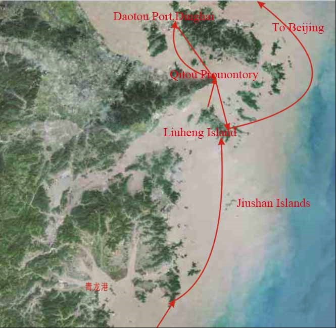
The sea route chart of the Zhoushan Archipelago for Macartney’s mission to China
In 1792, in order to establish the desired trade relationship with the Qing China, the British government sent the Macartney mission to China. Arriving in China’s waters in June 1793, the Macartney mission headed north through the Zhoushan Archipelago, where they stayed for several days, and then sailed out of Zhoushan’s waters on July 12. Sir George Stuanton’s An Historical Account of the Embassy to the Emperor of China records in detail the sea routes of the Macartney mission in Zhoushan (Staunton, 1797:206–209).
On the first of July they observed a cluster of islands, called the Quee-san. On the second of July, the squadron advanced near them and anchored in nine fathoms water.
…
The highest and most southerly of these, called by the English, Patchcock, bore north by west four miles. It is situated in latitude twenty nine degrees twenty two minutes north, longitude, by chronometer, a hundred and twenty one degrees fifty two minutes east.
…
On the third of July the squadron weighed anchor, and stood in, not without difficulty, nearer to Chu-san. a pilot was procured by the Hindustan. He conducted her off Tree-a-top island, and anchored her four miles to the southward of it; but the Lion and Jackall stood in, and came to between the Plough-man and Buffalo’s Nose.”
…
The Clarence, in her passage to Chu-san harbour, anchored, the first evening, a little to the southward of Kee-to-point, in seven teen fathoms water;
In this description, Chusan is the present Zhoushan; Patchcock is the passage between the present Meishan Island and Fodu Island); Tree-a-top island is present Liuheng Island; Buffalo’s Nose and the Plough-man are present Dongyushan and Xiyushan.
After the mission stayed more than ten days in Zhoushan, the Clarence returned to meet with the Lion via Liuheng Island, and weighed anchor on July 8. The fleet passed through the ocean, once anchored in the sea near Mount Putuo, and sailed out of Zhoushan waters on July 12.
According to the above description, the Macartney Mission’s voyage to Beijing via the Zhoushan Archipelago can be illustrated as follows (Fig. 18).
Conclusion
Many scholars believe that the rice cultivation of the Hemudu culture was spread to Japan through the Zhoushan Archipelago,12 while some scholars believe that Xu Fu set sail to Japan from Zhejiang, but from Zhejiang’s Xiangshan, not Zhejiang’s Zhoushan. Although these studies can hardly be the definitive final conclusions, we can at least explicitly identify numerous sea routes of the ancient Zhoushan Archipelago since Jianzhen’s eastward journey to Japan. The paper has successfully identified many sea routes which are documented historically, but it is impossible for this paper to cover all the sea routes of the Zhoushan Archipelago in ancient China. In fact, there are many other famous voyages through the Zhoushan Archipelago, but due to the limitations of relevant literature, they cannot be clearly described, interpreted and charted on the map. For example, when the eminent Japanese monk Huie was on the way back to Japan with the Buddhas he had retrieved from the Mount Wutai in China, he sailed past the Putuo Mountain of the Zhoushan Archipelago and accidentally started the Guanyin Buddhism culture because the Goddess of Guanyin (the goddess of Mercy) “refused to go” to Japan. This event is of great significance to the Chinese Buddhist culture and the cultural exchanges between China and Japan, yet we do not know the specific sea route Monk Huier took to and from Mount Putuo. There are many similar cases, but nonetheless, this does not fundamentally affect our overall understanding of the sea routes of the ancient Zhoushan Archipelago. From the review of the sea routes of the ancient Zhoushan Archipelago, it can be clearly seen that no matter in the East China Sea route or the South China Sea, along the Maritime Silk Road, the sea routes are not only numerous, but they have been very busy since the very early time. It also demonstrates the important position of the Zhoushan Archipelago in the ancient Chinese Maritime Silk Road, and is a well-deserved “maritime Dunhuang”.13
There is an inevitable reason why the Zhoushan Archipelago has transformed into the “maritime Dunhuang” on China’s Maritime Silk Road. As mentioned in the introduction of this paper, the unique monsoon climate in the East Asia and the unique ocean currents in the East China Sea create together the Zhoushan Archipelago’s unique geographical position on the Maritime Silk Road. It is exactly because of the unique monsoon climate here that passing ships (especially those traveling to the east) usually “stand for the wind and wait for the tide” in the Zhoushan Archipelago, waiting for the right time and favourable wind to set sail. This is also an important reason why the Zhoushan Archipelago have become the “maritime Dunhuang”. Since Mount Putuo became the Avalokitesvara Bodhisattva during the reign of Emperor Xuanzong of the Tang Dynasty, the passing vessels that waited for the wind and tide in the Zhoushan Archipelago went to the Avalokitesvara Bodhisattva to worship the Buddha, praying for safety and good luck during the long course of sailing, which was a hearted-rooted attitude of people in ancient times when their understanding of the ocean was far less than today. Praying for safety and good luck at sea is not only an important reason for the Zhoushan Archipelago to become the “Maritime Dunhuang”, but also adds a stronger cultural connotation to the “Maritime Dunhuang”.
Acknowledgements
The researchers would like to extend their genuine gratitude to the different organizations that have helped make this research possible: the National Social Science Fund of China for funding the research projects “British Writings from the Sea Voyages to China in the 17th-19th Centuries” (No.22BTQ011) and “Research on Maritime History of the Ancient Zhoushan Archipelago” (No.20FZSB042), the Federation of Philosophies, Humanities and Social Sciences of Zhejiang Province for funding the research project “Coastal China in 16th-19th English Literature” (No.21NDJC090YB) and China Scholarship Council.
Endnotes
References
- Dongfang, S, 2000.The Story of Ten Continents in the Sea, annotated by Xiong Xianguang. Chongqing: Chongqing Publishing House.
- He, G. &Yang, X. 2018. Analysis of Xu Fu’s Dongdu Crossing in the Qin Dynasty’s Navigation and Shipbuilding Technology. Research on the History of Maritime Communications, (2):86–95.
- Liu, Y., 2019. The Ancient Chinese Maritime Silk Road. Shenzhen: Haitian Publishing House.
- Lou, Z., 2017. Textual Examinations and Explanations of the Book Rubbings of Madam Cheng’s Epitaph in the Tang Dynasty Collected by Tang Jun. Journal of Zhejiang Ocean University (Humanities Edition), 34(6):68–76.
- Luo, H. & Xu M., 2014. Research on East Asian Monsoon Currents and the East China Sea Route of the Maritime Silk Road—Also on the Relationship between Zhoushan and the East China Sea Route of the Maritime Silk Road. Journal of Zhejiang International Maritime Vocational and Technical College, 10(4):37–43.
- Mao, Y., 2002. The Wu Bei Zhi (Volume 240), Edited by the Editing Committee of “the Revised Complete Library of the Four Treasures of Knowledge” (续修四库全书), in Volume 966 of The Revised Complete Library of the Four Treasures of Knowledge (续修四库全书). Shanghai: Shanghai Ancient Books Publishing House.
- Shi, Z., Huang, Y., et al. 2011. Guangxu’s “Dinghai Chronicle”, annotated and punctuated by Liu Heyong and Zhan Yayuan. Shanghai: Shanghai Ancient Books Publishing House.
- Sima, Q., 1959. The Records of the Grand Historian. Beijing: Zhonghua Book Company.
- Staunton, G., 1797. An Historical Account of the Embassy to the Emperor of China. London: J. Stockdale.
- Tang, J., 2007. Daishan Town Records (Volume 20). Yi Wen Ying Gan Miao Feng Ling Ji Hou Zhi, Zhoushan Ancient Records in Song, Yuan and Ming Dynasties, annotated by Ling Jinzuo. Zhoushan: Zhoushan Archives.
- Wang, J. (Eds.), 2017. Research and Interpretation of Place Names in the Zhejiang Section of the Maritime Silk Road. Hangzhou: Zhejiang Ancient Books Publishing House.
- Weng, Z., 2016. “The Historical Origin of Xu Fu and Dongsha” (http://dsnews.zjol.com.cn/dsnews/system/2016/01/27/020145392.shtml)
- Xia, Z., 2018. Textual Research on Mingzhou Section of Xu Jing’ Sea Routes. Journal of Zhejiang Ocean University (Humanities Edition), 35(4):69–75,81.
- Xiang, D., 2000. Zheng He’s Nautical Chart. Beijing: Zhonghua Book Company.
- Xiang, D., 2000. Two Kinds of Haidao Zhenjing. Beijing: Zhonghua Book Company.
- Zhang, J., 2007. Changguo County in Volume 7 of Qiandao’s “Si Ming Tu Jing”, Zhoushan Ancient Records in Song, Yuan and Ming Dynasties, annotated by Ling Jinzuo. Zhoushan: Zhoushan Archives
- Zhenren, Y. (おうみのみふね), 2000. The Great Master of the Tang Travels East. Annotated by Wang Xiangrong, Beijing: Zhonghua Book Company.
- Zheng, R., 1986. Zheng Kaiyang’s Miscellany, photocopy of Wenyuange Siku Quanshu (Volume 584). Taibei: Taiwan Commercial Press.