No Island is an Island: Understanding the Geo-social Interaction of Small Islands in the Philippine Archipelagoscape
Abstract
Studies that focus on archipelagos and the interaction between and among islands in an archipelago are lacking. This study aims to contribute to this emerging discussion by determining the geo-social interactions of small islands in the Naranjo Group of Islands, Philippines. Using Social Network Analysis (SNA), descriptive network connectivity statistics — degree centrality, geographical centrality, and network density indices were generated. The geo-social interaction intensity (GSII) index was also calculated to assess the degree of geo-social interactions of the small islands. The geo-social interaction between and among islands in the Naranjo Group of Islands involves access or exchange of resources, goods, and services. The degree of geo-social interaction in the archipelagoscape was influenced by the islanders’ need to access resources, resource availability, distance, weather, transport, and sea condition. The degree of linkages between and among islands in an archipelagoscape serves as a safeguard during a disturbance by promoting resilience against challenges by ensuring continued access to resources or constraining its spread. The study recommends a strengthened geo-social interaction to ensure a continued flow of goods and services necessary for island existence, survival, and well-being. Further research on the relationship between island resilience and connectivity from an archipelagic perspective is also suggested.
Keywords
archipelago, archipelagoscape, connectivity, geo-social interaction, small island
1. Introduction
Islands are generally characterized as remote, marginal (O’Connor, 2019), and isolated (Fernandes & Pinho, 2017; O’Connor, 2019; Ratter, 2018), but their existence is determined by their connection with the sea, the mainland, and other islands (Ratter, 2018). The island’s topological relations are categorized in island studies into three (3): land and sea, island and mainland, and island and island (Stratford et al., 2011). The first island relation focuses on the island’s singularity, isolation, and uniqueness (Stratford et al., 2011). An island is traditionally defined as “a piece of land surrounded by water” (Royle, 1989). The second island relation focuses on the relationship (Baldacchino, 2006) and differences between islands and the mainland in terms of “size, presence/absence, sufficiency/insufficiency, positivity/negativity, completeness/lack” (Gibson-Graham, 1998; as cited in the study of Stratford et al., 2011). The third topological relation focuses on the interactions between and among islands in an archipelago (Stratford et al., 2011).
Yet, there are limited studies on archipelagos (Lewis & Wigen, 1997) and archipelagic relations (Stratford et al., 2011). Stratford and her associates (2011) called for the development of archipelago studies to understand its concept. They envisioned the archipelago as seas studded with islands or a chain of islands that relate to one another. The works of a few authors support this archipelagic perspective. Hau’ofa (1993) reconceptualized the Pacific Islands as a sea of islands in contrast to the idea of looking at them as isolated islands. DeLoughrey (2001) argues that no island is an isolated island, for the islands in an archipelago have a fluctuating relationship with their surrounding seas, islands, and continents. Hofman et al. (2007) used the concept of island rhythms to express the dynamics of inter-community exchange relationships across the archipelago through time. Hayward (2012) coined the term aquapelago and defined it as an “assemblage of the marine and land spaces of a group of islands and their adjacent waters.” Pugh (2013) suggests the island-island movement as a way of thinking archipelagically.
Stratford et al. (2011) stated that knowing how the islander views or experiences disconnection, connection, and entanglement between and among islands is essential in understanding the archipelagos. Using social network models, Hage and Harary (1996) illustrated the islands’ connectivity in the Pacific to other island societies in the past through kinship and marriage relationships, trade, tribute practices, languages, and histories. Hofman et al. (2007) studied the precolonial Caribbean islandscape and the intercommunity exchange relationships in the Lesser Antillean archipelago. Using Social Network Analysis, Hidalgo, Ther, Saavedra, and Diaz (2015) identified the economic and socio-spatial links between islanders and islands of the Quinchao archipelago, Chile. Hofman et al. (2007) stated that the exchange or reciprocal movement of materials, goods, persons, valuables, and knowledge through human interaction in an archipelago is a complex web of symbiotic social relationships and meanings that produces intricate networks.
Moreover, Dawson (2012) and Petzold (2017) pointed out that archipelagic studies must explicitly include the sea in studying archipelagic relations (Dawson, 2012; Petzold, 2017), for it serves as the source of connectedness (Erlandson, 2008; Mehmood, 2009; Dawson, 2012) and isolation (Dawson, 2012) of islands. The dynamics of interaction between and among islands are influenced by maritime conditions (Grydehøj & Casagrande, 2019), the motivation of the people to travel depending on their social and economic needs (Surya, 2015), distance, and the availability of transport (Grydehøj & Casagrande, 2019; Surya, 2015). The geo-social interaction in an archipelago shapes the resourcefulness and resilience of small islands (Cross, 1996), for it facilitates the flow of products, people, services, or information (Hau’ofa, 1993; Lazrus, 2012) that are critical for survival (Ratter, 2018), especially for archipelagic countries like the Bahamas, Fiji, Grenada, and the Philippines, identified to be the most adversely affected by extreme weather events (Eckstein et al., 2019).
This study aims to contribute to this emerging discussion by looking at an archipelago from a landscape perspective to understand how geographical and social factors influence the interactions of islands (Lape, 2004). Dakos et al. (2015) stated that the idea of connectivity in the context of a spatially explicit landscape extends to every system that can be conceptualized as a sum of individual components. Connectivity describes the degree of interactions between entities in a socio-ecological system (Dakos et al., 2015). Connectivity facilitates the flow of energy, material, or information necessary for the resilience (Nyström et al., 2001) of small islands in an archipelago. In this study, an island group is viewed as an archipelagoscape, a mosaic of a group of spatially heterogeneous interacting islands whose interrelationships are defined by the spatial and social connectivity between and among islands in terms of availability and access or exchange of resources, goods, services, information, and other social interactions influenced by the interconnectivity of waters surrounding them. The geo-social interaction between and among small islands in the Naranjo Group of Islands, Philippines, was determined. The purpose, mode, and frequency of travel of households in the island group were asked. Results were analyzed using social network analysis (SNA) to illustrate the geo-social interactions in the Naranjo Group of Islands, Philippines. The degree centrality, geographical centrality, network density, and geo-social interaction intensity index were calculated.
2. Study
2.1 Study Site
The Philippines is an archipelagic country located in Southeast Asia. It is an elongated, fragmented, terraqueous, and poorly connected state (Boquet, 2017), consisting of 7,641 (National Mapping and Resource Information Authority, 2017) islands with a total land area of approximately 300,000 km2 and 36,289 km. of coastline (National Mapping and Resource Information Authority, 2012). The country consists of three main island groups — Luzon, Visayas, and Mindanao (Republic of the Philippines National Government Portal, n.d.). The study was conducted in the Visayas, specifically in San Vicente, Northern Samar (Fig. 1 Location Map of San Vicente, Northern Samar, Philippines). The municipality was purposively selected for the area is an archipelagoscape that consists of seven (7) small islands (Destacado, Aguada, Darsena, Escarpada, and San Andres, Rasa, and Medio) collectively called the Naranjo Group of Islands (San Vicente, Northern Samar Comprehensive Development Plan, 2019–2023).
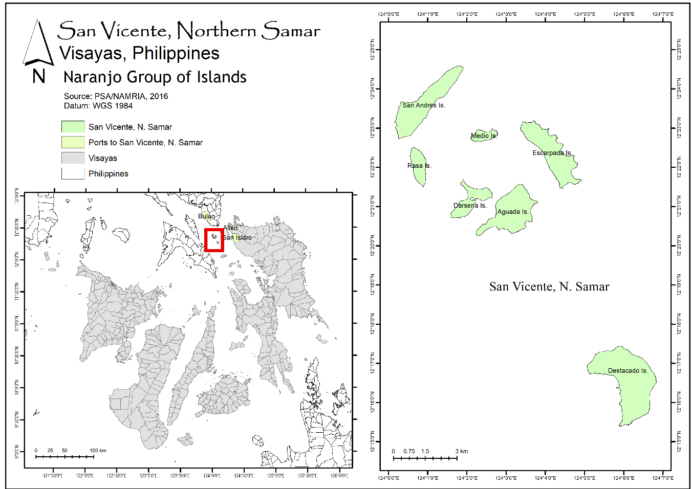
The island group lies between 12º15’ to 12º24’ north latitude and 124º0’ to 124º7’ east longitude and is only accessible by sea. The island group covers a total land area of about 1,860 hectares (San Vicente, Northern Samar Municipal Profile, 2017). San Vicente, Northern Samar, was created into a municipality in 1966 under the Republic Act 4761 (An Act Creating the Municipality of San Vicente in the Province of Samar). It comprises seven barangays. Three (3) are in Destacado Island, where the población (municipal center, Romani, 1956) is, Destacado, Punta, and Mongolbongol. The other four island barangays are Barangay Tarnate (Aguada Island), Barangay Sila (Darsena Island), Barangay Sangputan (Escarpada Island), and Barangay Maragat (compose of San Andres, Rasa, and Medio Island) (Republic Act 4761). It is a sixth (6th) class municipality (Philippine Statistics Authority, 2019) wherein farming and fishing are the two main livelihoods (San Vicente, Northern Samar Comprehensive Development Plan, 2019–2023).
2.2. Geo-social Interactions of Small Islands
The study aims to determine the geo-social interaction of the small islands in the Naranjo Group of Islands using Social Network Analysis. In this study, geo-social interaction refers to the spatial and social interaction between and among islands in a group regarding the availability, access, or exchange of resources, goods, services, information, and other social interactions. Social Network Analysis (SNA) is a powerful and relatively new tool that can be used to assess networks (Jaja, Dawson, & Gaudet, 2017). The degree centrality, geographical centrality, network density, and the Geo-social Interaction Intensity (GSII) Index were calculated.
The respondents (household heads or, in their absence, any household member who is 18 years old and above) were asked about their geo-social interaction with the Naranjo Group of Islands in terms of purpose, frequency of travel, and transport using an interview schedule. About 79% (1333) of the island group’s households participated in the study and were considered to represent the entire population (Cassidy & Barnes, 2012). The study aimed for a complete enumeration, but it was unfeasible for some were unavailable, refused, incapable (e.g., deaf), and failed to complete the survey. Moreover, Destacado, Aguada, Darsena, and Escarpada Island were considered geo-social units. Since San Andres, Rasa, and Medio Island belong to one political unit — Barangay Maragat, and only a few households reside in Rasa (<30) and Medio (<10) Island, they were considered one geo-social unit. The study was conducted between mid-December 2018 and March 2019. Transport availability, safety to travel, and weather conditions were considered during the study.
The data obtained from the survey was encoded in Microsoft Excel to create connectivity matrices and describe the households’ geo-social interactions with other islands in the group. Each household was represented as a node in the network analysis. Weighted matrices were used to describe the geo-social interactions in terms of the flow of goods and services. The household names were removed and coded (e.g., d1, d2, d3, dn for Destacado Island) to maintain confidentiality. The connectivity matrices were then transposed to generate a place-to-place adjacency matrix. Transposing the data was done by switching its rows with its columns (Borgatti, Everett, and Johnson, 2009). The matrices were imported into the Gephi software (Bastian, Heyman, & Jacomy, 2009) to generate descriptive network connectivity statistics.
Degree centrality indices
Degree centrality measures the number of direct ties a node has with others in the network (De Nooy, Mrvar, and Batagejl, 2018). A high degree means a well-connected island. A low degree could result in disconnection or isolation from the other islands in the island group. There are two (2) degree centrality measures: in-degree and out-degree centrality. In-degree centrality refers to the number of coming-in connections. Out-degree refers to the number of going-out links from a node in a network (Mohammadfam et al., 2015). In this study, in-degree centrality implies the importance of an island to other islands in the group. Out-degree implies an island’s dependence on other islands in the group for resources necessary for their existence, survival, and resilience. The weighted in-degree and out-degree centrality indices were computed to determine the interactions of the small island using the formula below:
$$ {Cd}_i (i)= { {\sum_j^n I_{ji(w_{ft})} } \over N} $$
where the \(Cd_i(i)\) is the in-degree centrality of small island \(i\), \(I_{ji}\) is the number of households who depart from small island \(j\) to the small island \(i\), \(w_{ft}\) is the weight for the frequency of travel (\(w_{ft}\)) of households in small island \(j\) to \(i\), \(n\) is the total number of small islands in the Naranjo Group of Islands, and \(N\) is the total number of households in the island group.
$$ {Cd}_o (i)= { {\sum_j^n I_{ij(w_{ft})} } \over N} $$
where the \(Cd_o(i)\) is the out-degree centrality of small island \(i\), \(I_{ij}\) is the number of households who departs from small island \(i\) to small island \(j\), \(w_{ft}\) is the weight for the frequency of travel (\(w_{ft}\)) of households in the small island \(i\) to \(j\), \(n\) is the total number of small islands in the Naranjo Group of Islands, and \(N\) is the total number of households in the island group.
Geographical Centrality Index
In this study, the geographical centrality index refers to an island’s closeness to all islands in the Naranjo Group of Islands, wherein a higher value implies a closer connection. The geographical centrality index was calculated by the inverse of the sum of all the spatial distances from small island i to every island in the island group. The closer the distance to other islands in the group, the higher the islanders’ spatial interaction to access resources crucial to their survival and resilience.
The formula for measuring the Geographical Centrality Index is:
$$ G_c (i)= {1\over{\sum_j^n\,d_{ij}}} $$
where \(d_{ij}\) is the spatial distance between \(i\) and \(j\).
Network density
The network density index was calculated to determine the interconnectedness of the small islands in the group. The network density refers to the total number of direct relations between nodes in a network divided by the number of possible relations (Katharina, 2018; Han & Liu, 2018). This measure has values between 0 and 1. A score of 1 implies that all network nodes are connected, while 0 indicates that the nodes are entirely disconnected (Mohammadfam et al., 2015).
2.2.1. Geo-Social Interaction Intensity Index (GSII)
Zwier et al. (1995) stated that the degree of insularity and connectedness could be described as the extent of linkage between islands in space and time. The intensity of the geo-social interaction of small islands in the island group was determined by modifying the formula used in the study of Han and Liu (2018):
$$ GSII_{ij}=\left[ {\sum(I_{ij} w_{ft}) \over N_i} + {\sum(I_{ji} w_{ft}) \over N_j} \right]/2 $$
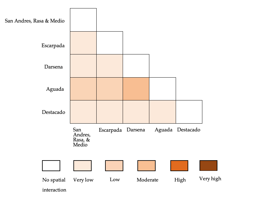
where \(GSII_{(i,j)}\) is the interaction intensity between small island \(i\) and \(j\), \(I_{ij}\) is the household from small island \(i\) that travels to island \(j\), and \(I_{ji}\) is the household from small island \(j\) who travels to the small island \(i\). \(N\) refers to the total number of households on an island. The highest frequency of travel of each household was used as a weight to determine the degree of interaction between islands \(i\) and \(j\). The weights for the frequency of travel (\(w_{ft}\)) were as follows: 7 for traveling several times a week, 6 for once a week, 5 for several times a month, 4 for once a month, 3 for several times a year, 2 for once a year, 1 for rare or occasional travel, and 0 for never. These weights were normalized to have comparable values. The intensity of geo-social interaction between island and island were classified as very high (.81 to 1.00), high (.61 to .80), moderate (.41 to .60), low (.21 to .40), very low (.01 to .20), and no spatial interaction (0).
3. Results and Discussions
3.1 Geo-social Interaction of Small Islands in the Island Group
The geo-social interaction between and among islands in the Naranjo Group of Islands involves access or exchange of resources, goods, and services. The connections between and among islands in San Vicente, Northern Samar, are essential in obtaining food, satisfying basic needs (Ratter, 2018), and enhancing social relations. The islanders travel from one island to another within the island group either by using their boat, borrowing a boat from their friends, relatives, neighbors, or renting a boat. Nearly half of the households in Destacado (40%) and Escarpada (45%) Island own a boat/pump boat. A higher percentage of households in Aguada (58%), Darsena (53%), and San Andres, Rasa, and Medio (54%) Island own a boat/pump boat. The boat rental fee from Destacado Island to other islands and vice versa may range from Php800 to Php2500 depending on the weather, size of the vehicle, number of islands to be visited, and the number of passengers. The islanders from Destacado Island can ride in a public passenger vehicle that travels from their island going to Bulan, Sorsogon on Mondays and picks up passengers at Aguada and Escarpada Island. Also, the islanders from Aguada, Darsena, Escarpada, San Andres, Rasa, and Medio Island can ride in this public passenger vehicle on its return trip to Destacado Island on Tuesdays. The passengers can also wait at the shore for boatmen from the other islands for a free ride or a minimal fee. The availability of transport facilitates the connectivity of small islands in the archipelagoscape.
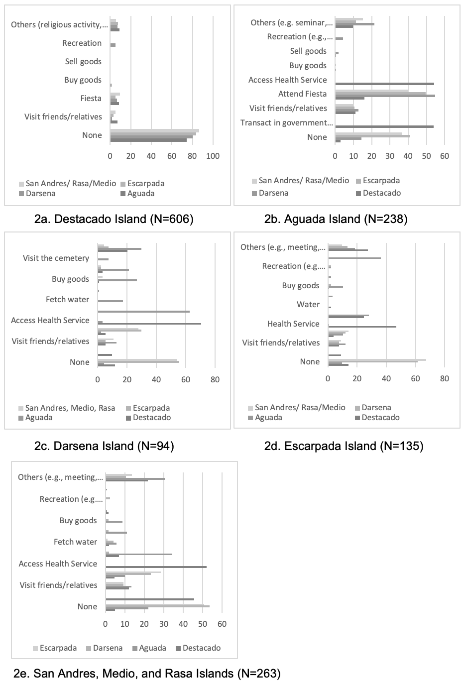
Destacado Island is the población of San Vicente, Northern Samar, wherein government, health, education, water, electricity, and many business establishments are available. Destacado Island is visited by many households from other islands occasionally (Fig. 3), mostly to access health services and to transact in government offices (Fig. 2). The households in Escarpada (24%) and San Andres, Rasa, and Medio (7%) Island travel to Destacado Island to access education. San Vicente, Northern Samar, has five (5) elementary schools located in Destacado, Aguada, Darsena, Escarpada, and San Andres Island, and two secondary schools in Aguada and Destacado Island (San Vicente, Northern Samar Comprehensive Development Plan, 2019–2023).
Because of the availability of goods and services on Destacado Island, only about 25% (Fig. 2a) of its households travel to the other islands in the group to visit friends and relatives, attend fiestas, buy and sell goods, recreation, and other activities, e.g., religious and school activities. A fiesta is a religious festival held to honor a patron saint (Boquet, 2017) wherein the locals prepare food in their houses and invite people to visit and dine with them. Parades, variety shows, games, and other colorful activities are also part of the celebration, enabling the community to socialize, have fun, and celebrate each year’s blessings. The households also from other islands travel to other islands in the group to visit their relatives or friends, attend fiestas, and others, e.g., meetings, religious fellowship, and school activities (Fig. 2). The result signifies the importance of family and kinship in the island group. According to Hofmann & Lübken (2015), family relations of clans and kin lines in inter-island networks serve as a lifeline and insurance system during calamities. It facilitates the exchange of resources, e.g., donations of food, seedlings, or provision of temporary sanctuary that helps to alleviate the impact of disasters. When disaster diminishes the food supply and threatens the survival of an island population, the people may take refuge or seek assistance from neighboring islands with which they maintain ties of reciprocity (Alkire, 1965).
Darsena Island is occasionally visited for recreation purposes (Fig. 2), e.g., picnic and swimming, by the households from other islands. San Vicente, Northern Samar, is an eco-tourism zone under Republic Act No. 9458 (2007), wherein Darsena Island is known for its pink beaches. The sustainability of small islands is influenced by tourism resources (Kelman, 2019). Tourism is a development strategy (Polnyotee & Thadaniti, 2015), especially for a group of small islands with limited economic resources. The products produced in the island group, e.g., dried fish, can be sold to tourists locally. Promoting tourism activities on Darsena Island will boost the island group’s local economy and economic relations by creating other economic opportunities for the island group (e.g., transport of tourists, accommodation of tourists in nearby islands, marketing of local products).
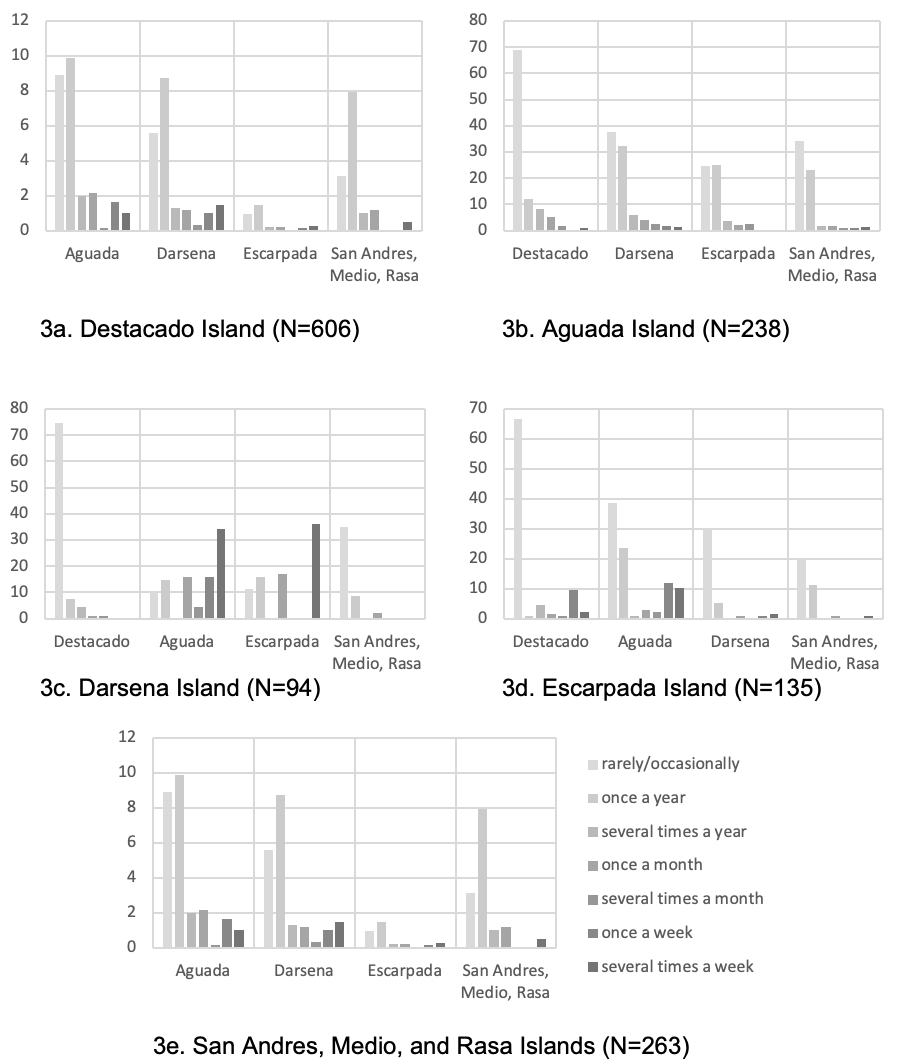
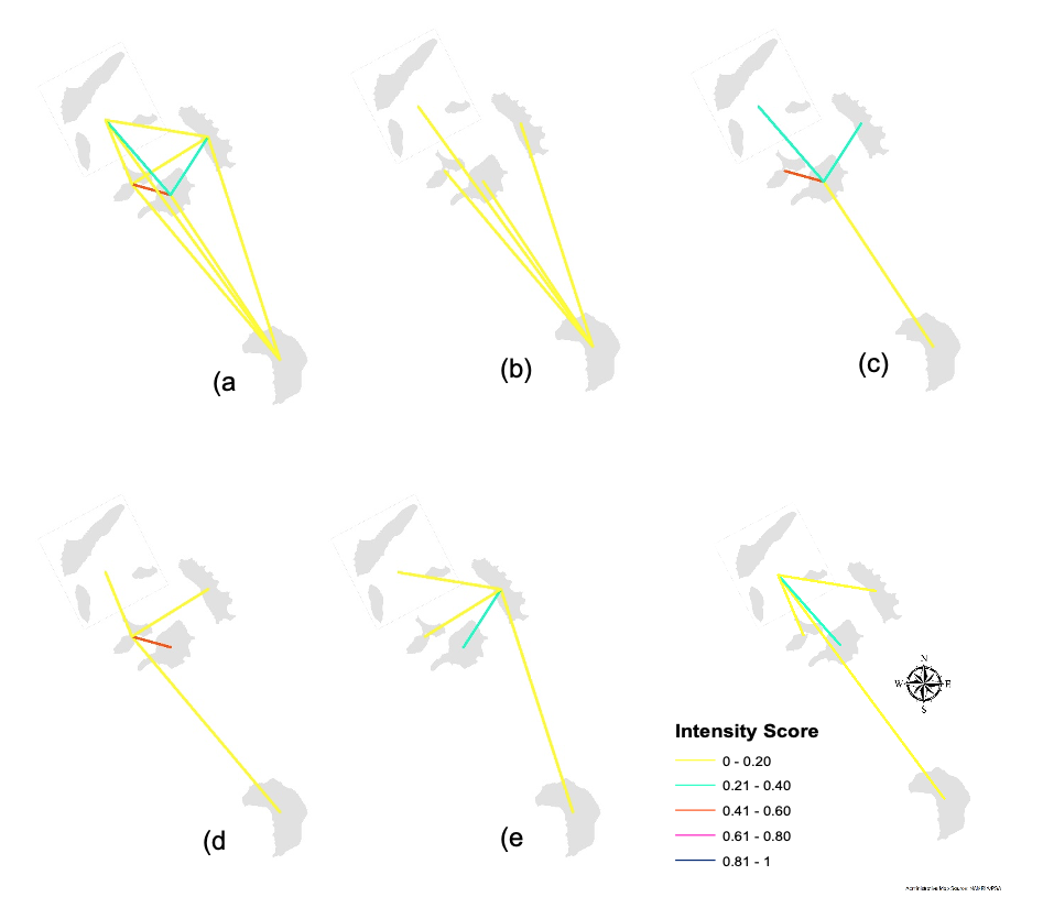
Darsena, Escarpada, San Andres, Medio, and Rasa Islands depend most on Aguada Island for goods and services. Almost all households in Darsena Island (96%) travel to Aguada Island, wherein about 34% visit the Island several times a week, about 16% visit once a week, and about 16% once a month (Fig. 3c). Most households (90%) in Escarpada island travel to Aguada Island, wherein about 10% of the households visit the island several times a week while about 12% travel to the island once a week (Fig. 3d). The majority (78%) of the households in San Andres, Rasa, and Medio Island travel to Aguada Island, wherein 12% of the households visit the island several times a week and about 29% visit once a week. About 18% travel to Aguada Island rarely or occasionally, and about 7% travel once a year (Fig.3e). The households from these islands travel to Aguada Island to access education, buy goods, sell goods, and visit the cemetery (Fig. 2c, 2d, & 2e).
Moreover, water is one of the limited resources on the island. The households in Darsena (17%) and San Andres, Medio, and Rasa (6%) Island travel to Aguada Island to access water (Fig. 2b). Aguada Island has a Level II water system sourced from its natural springs in Sitio Ka-Uhing and Sitio Dao. Level II (communal faucet system or stand posts) refers to “a system composed of source, a reservoir, piped distribution network and communal faucets, located no more than 25 meters from the farthest house” (Department of Health Administrative Order No. 2007-0012). Moreover, a few households in Escarpada (2%) and San Andres, Medio, and Rasa (2%) Island access water on Destacado Island (Fig.2a). Water sources of small islands are highly vulnerable to climate change due to their limited size, availability, and physical characteristics (Máñez et al., 2012). The Philippines is particularly vulnerable to climate change impacts due to its location, archipelagic formation in the tropical Pacific, and population distribution (Philippine Climate Change Commission, 2011). Water resource management through the involvement of all stakeholders in the island group is critical to conserving the resource adequately.
3.2 Degree Centrality Indices
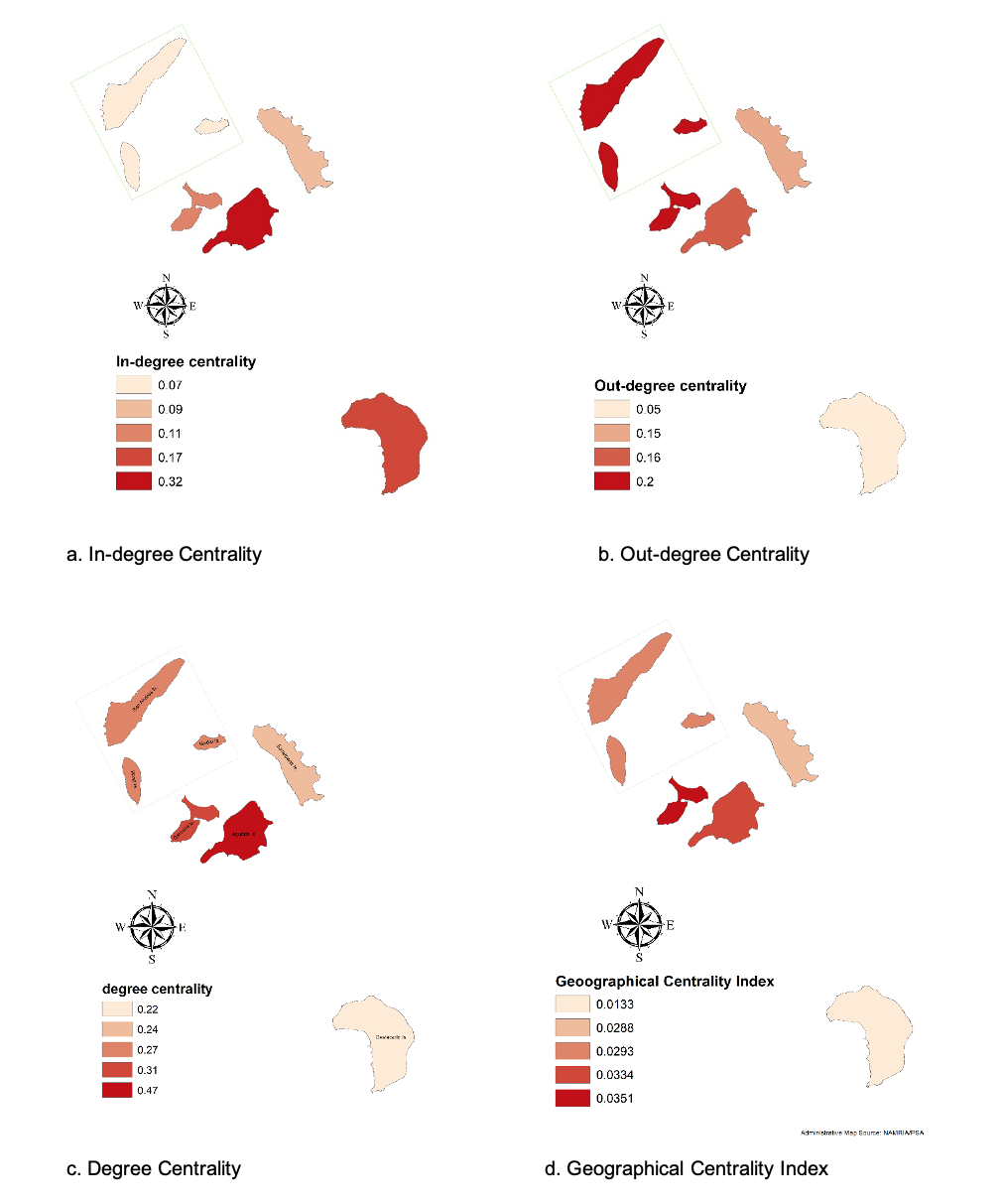
Degree centrality is the number of links an island has (Borgatti, Everett, & Johnson, 2009). A high degree centrality score indicates that the island is well-connected. On the other hand, a low degree centrality could result in isolation from the other islands in the group. There are two types of degree centrality — the in-degree and out-degree. Fig. 4a shows the in-degree of the Naranjo Group of Islands. In-degree centrality refers to the number of coming-in connections (Mohammadfam et al., 2015). In this study, in-degree centrality implies the importance of an island to other islands in the group.
The results showed that Aguada and Destacado Island obtained the highest weighted in-degree centrality index of 0.32 and 0.17, respectively. The results imply that Aguada Island is one of the most crucial islands in the Naranjo Group of Islands, where the islanders could depend on resources. On the other hand, Destacado Island is politically significant for it serves as the población of San Vicente, Northern Samar. Government, education, and health services are primarily available on Destacado Island. The accessibility of these two islands, especially during calamities, is critical for the survival of the other islands dependent on them. The dependence of small islands on their neighboring islands in the group fills their shortage of goods and other resources, whether due to their characteristics or the effects of a disaster. The geo-social relations between and among islands allow wider economic goods distribution, resulting in a greater resource base than that available to any single island (Alkire, 1965). However, the access of other islands, especially to natural resources, e.g., water, puts additional pressure and, if left unchecked, may not be sustained over time (Chand, 2001). Managing and conserving these natural resources is crucial for their continued enjoyment and utilization.
Figure 4b shows the out-degree centrality of the Naranjo Group of Islands. Out-degree centrality refers to the number of outgoing connections (Mohammadfam et al., 2015). Darsena, San Andres, Rasa, and Medio Islands obtained the highest weighted out-degree centrality index score of 0.20. The out-degree centrality could imply islands’ ability to access resources beyond their shores necessary for their existence, survival, and resilience or dependence of one island on other islands for resources. Small islands have limited resources (Deschenes & Chertow, 2004), and the island communities’ ability to access goods and services is indicative of resilience (Langridge, Christian-Smith, & Lohse, 2006; Spilanis, Kezos & Petsiote, 2012) and sustainability (Spilanis, Kezos, & Petsiote, 2012). Island communities with high and diverse sources can be considered more socially connected and less isolated (Peterson, 2015). However, during calamities, small islands that are heavily dependent on other islands are most likely to be adversely affected, for the interactions of islands during these trying times are most likely to be disrupted. Thus, small island communities need to optimize their limited available resources to reduce their vulnerabilities to disasters, maintain nature’s life support functions (Staff of Christian Aid et al., 2011) and sustain island life.
The out-degree centrality scores further showed that Destacado Island obtained the lowest out-degree centrality score of 0.05, implying that Destacado Island has the slightest interaction with the other islands in the Naranjo Group of Islands. Fitzpatrick and Anderson (2008) stated that not all island societies maintain connections beyond their shores. Cross and Nutley (1999) explained that resource availability reduces the islands’ dependence on other islands. As mentioned earlier, Destacado Island is the población of San Vicente, Northern Samar, wherein essential services are available. In addition, public transport services to the mainland, which provide markets for islanders’ products and other services (Tacoli, 1998), are available on Destacado Island, thus reducing Destacado island’s interaction and the need to interact with other islands in the group.
The overall degree centrality score is shown in Figure 4c. Aguada Island has the highest weighted degree centrality score of .47, followed by Darsena Island with a weighted degree centrality score of 0.31. San Andres, Rasa, and Medio Island have a weighted degree centrality score of 0.27, while Escarpada Island has a weighted degree centrality score of 0.24. Destacado Island has the lowest degree centrality score of 0.22 (Fig. 4a). The geo-social interaction between and among islands shapes their resourcefulness and resilience (Cross, 1996) as it facilitates the flow of products, people, services, or information (Hau’ofa, 1993; Lazrus, 2012) that are critical for survival (Ratter, 2018).
3.3. Geographical Centrality Index
The geographical centrality index refers to a node’s nearness to all the other nodes in a network, wherein a higher value implies a closer connection. The closer the distance to other islands in the group, the higher the islanders’ spatial interaction to access resources crucial to their survival and resilience. Figure 4d showed that Aguada (0.058) Island has the highest geographical centrality index scores. The island is at the center, thus the closest to all islands in the Naranjo Group of Islands. Moreover, Aguada Island is the most accessed island. Darsena, Escarpada and San Andres, Rasa, and Medio Island have geographical centrality index scores of 0.049, 0.043 and 0.051, respectively, while Destacado Island obtained the lowest geographical index score of 0.013, the farthest island in the group. The results imply that islanders prefer accessing resources in areas that require less time, money, and energy (Donnges, 2003).
The results can be further explained by Tobler’s ‘first law of geography,’ wherein “everything is related to everything else, but near things are more related than distant things” (Tobler, 1970). Zwier et al. (1995) stated that distance is the central variable that reflects an area or a group of people’s isolation. However, some authors argue that distance alone does not say much about an island’s isolation, remoteness, or disconnectedness (Fernandes & Pinho, 2017; Ratter, 2018). The dynamics of interaction between and among islands are also affected by the availability of transport (Grydehøj & Casagrande, 2019; Surya, 2015), the motivation of the people to travel depending on their social and economic needs (Surya, 2015), and sea conditions (Grydehøj & Casagrande, 2019). Regardless of distance, interisland transport availability improves islands’ connectivity and the transport of goods and services (Asian Development Bank, 2012). The absence of public inter-island transport in the Naranjo Group of Islands limits the islanders’ movement to access goods and services.
3.4 Network Density Index and Geo-social Interaction Intensity (GSII) Index
The network density was calculated to determine the small islands’ connectivity in the Naranjo Group of Islands. The network density indicates the general level of relations of a network (Furht, 2010;13) (e.g., island group), wherein the score of 1 implies that all nodes in the network are connected, while a 0 score indicates that the nodes are entirely disconnected (Mohammadfan et al., 2015). A score of 1 was obtained, suggesting that the small islands are interconnected. The primary geo-social interaction of small islands in the Naranjo Group of Islands includes access to goods and services, e.g., education and health.
The degree of interaction was calculated to analyze further the small islands’ geo-social interaction in an archipelagoscape (Figures 5 and 6). Darsena, Escarpada, San Andres, Rasa, and Medio Island have a higher geo-social interaction with Aguada Island. Darsena Island and Aguada Island have moderate geo-social interaction with an intensity score of 0.45. Darsena Island is the nearest island to Aguada Island. On the other hand, Destacado Island, the farthest island in the group, has very low connectivity with Aguada, Darsena, and Escarpada Island, with an intensity score of 0.17, 0.12, and 0.16, respectively. The Geo-Social Interaction Intensity (GSII) Index score between Darsena and Aguada Island is the highest in the island group due to more frequent trips (Fig. 3) influenced by the need to access resources. Their socio-spatial characteristics influence the degree of interaction of small islands in the Naranjo Group of Islands. The heterogeneity of resources in the island group influenced the islanders to interact with other islands (Allen, 1996; Lape, 2004) for their survival, existence, and well-being. For example, the islanders in Darsena Island travel to Aguada Island to sell their catch, fetch water and study high school. Darsena Island, on the other hand, is visited for its pink sand beaches.
Geo-social interaction in the Naranjo Group of Islands is critical for small islands are challenged by limited available resources, weak resource security, and limited natural carrying capacity (Deschenes & Chertow, 2004). The exchange or reciprocal movement of materials and other resources in an archipelago is an intricate web of symbiotic relationships (Hofman et al., 2007) facilitating the flow of energy, material, or information (Nyström et al. 2001) that sustain island life. However, not all island societies maintain connections beyond their shores (Fitzpatrick & Anderson, 2008). The degree of interaction of islands in an archipelagoscape is influenced by their need to access resources, availability of resources, distance, weather, transport, and maritime condition.
The strength and structure of these islands’ connectivity may safeguard against a disturbance by facilitating recovery (Dakos et al., 2005; Nyström et al., 2001) or constraining the spread of disturbance (Nyström et al., 2001). According to Thaman (2008), the strength of these linkages serves as a lifeline that promotes resilience against local challenges to resource access, especially during emergencies. Small islands’ survival strategies, especially those remotely situated, are intimately connected with the ability to source and obtain resources (Baldacchino, 2006; Ratter, 2018) from other islands. Moreover, the sea is the source of connectedness (Erlandson, 2008; Mehmood, 2009; Dawson, 2012) of these small islands, and if the sea conditions are hostile (e.g., due to weather conditions), regardless of nearness or distance, the island is inaccessible (Di Piazza, Di Piazza, and Pearthree, 2007), resulting to their isolation (Dawson, 2012). Sea travel in the Philippines is prohibited when the weather and maritime conditions are not favorable (Philippine Coast Guard Memorandum Circular No. 01–09, s.2014). The study suggests a strengthened geo-social interaction to ensure a continued flow of goods and services necessary for island existence, survival, and well-being.
4. Conclusions
This study aims to contribute to the emerging studies that focus on archipelagos and the interaction between and among islands by determining the geo-social interactions of small islands in the Naranjo Group of Islands, Philippines. The geo-social interactions of the small islands were determined using Social Network Analysis (SNA). Descriptive network connectivity statistics (degree centrality, geographical centrality, and network density indices) were generated. The geo-social interaction intensity (GSII) index was also calculated to assess the degree of geo-social interactions of the small islands.
The small islands in the Naranjo Group of Islands were linked by political, economic, and social ties. The islanders travel from one island to another within the island group either by using their boat, borrowing a boat from their friends, relatives, neighbors, renting a boat, or occasionally riding in public transport. The geo-social relations between and among small islands promote island communities’ existence, survival, and well-being. These relations promote the local economy and strengthen social ties and kinships in the island group. The interaction between and among islands fills the shortage of goods and resources of other islands. However, these geo-social relations may put additional pressure on islands where these resources are accessed. A landscape approach to managing natural resources is crucial for the island communities’ continued enjoyment and utilization.
The degree of geo-social interaction in an archipelagoscape is influenced by the islanders’ need to access resources, resource availability, distance, weather, transport, and sea condition. The degree of linkages between and among islands in the island group serves as a safeguard during a disturbance by promoting resilience against challenges by ensuring continued access to resources or constraining its spread. However, resource access to other islands is most likely disrupted during calamities, especially for areas prone to hazards and disasters. Small island communities need to optimize their limited available resources to sustain their island life. The study recommends a strengthened geo-social interaction to ensure a continued flow of goods and services necessary for island existence, survival, and well-being. Further research on the relationship between island resilience and connectivity from an archipelagic perspective is also suggested.
Acknowledgments
The Philippine Commission on Higher Education (CHED) funded the research through its dissertation grant under the CHED-K12 scholarship program.
References
- Allen, M.S., 1996. Patterns of interaction in Southern Cook Island prehistory. Bulletin of the Indo-Pacific Prehistory Association, 15, pp.13–21.
- Alkire, W.H., 1965. Lamotrek Atoll and inter-island socioeconomic ties. University of Illinois at Urbana-Champaign.
- Asian Development Bank., 2012. Philippines: Transport Sector Assessment, Strategy, and Road Map. Mandaluyong City, Philippines
- Baldacchino, G., 2006. Islands, island studies, island studies journal. Island Studies Journal, 1(1), 3–18.
- Bastian, M., Heymann, S., Jacomy, M., 2009, March. Gephi: an open source software for exploring and manipulating networks. In Third international AAAI conference on weblogs and social media.
- Boquet, Y., 2017. The Philippine Archipelago (p. 321). Cham: Springer.
- Borgatti, S. P., Everett, M. G., Johnson, J. C., 2013. Analyzing social networks. Thousand Oaks, CA: SAGE Publications Ltd.
- Cassidy, L., Barnes, G. D., 2012. Understanding household connectivity and resilience in marginal rural communities through social network analysis in the village of Habu, Botswana. Ecology and Society, 17(4).
- Chand, S., 2001. Managing natural resources in the Pacific Islands. Resource Management in Asia Pacific Developing Countries.
- Cross, M. D., 1996. Service Availability and Development among Ireland’s Island Communities—the Implications for Population Stability. Irish Geography, 29(1), 13–26.
- Cross, M., S. Nutley. 1999. Insularity and Accessibility: The Small Island Communities of Western Ireland. Journal of Rural Studies, Vol. 15, No. 3, pp. 317–330.
- Dakos et al., 2005. Principle 2 — Manage connectivity. In: Principles for Building Resilience: Sustaining Ecosystem Services in Social-Ecological Systems, eds R. Biggs, M. Schlüter and M. L. Schoon. Published by Cambridge University Press. Author 1, A.; Author 2, B. Book Title, 3rd ed.; Publisher: Publisher Location, Country, 2008; pp. 154–196.
- Dawson, H., 2012. Archaeology, aquapelagos and island studies. Shima: The International Journal of Research into Island Cultures, 6(1), 17–24.
- Department of Health Administrative Order No. 2007-0012., Philippine National Standards for Drinking Water 2007. Available online: http://spsissuances.da.gov.ph/attachments/article/891/ao2007-0012.pdf (accessed on 10 December 2019).
- Deschenes, P. J., Chertow, M., 2004. An island approach to industrial ecology: towards sustainability in the island context. Journal of Environmental Planning and Management, 47(2), 201–217.
- Di Piazza, A., Di Piazza, P., & Pearthree, E. (2007). Sailing virtual canoes across Oceania: Revisiting island accessibility. Journal of Archaeological Science, 34(8), 1219–1225.
- DeLoughrey, E., 2001. The litany of islands, the rosary of archipelagoes: Caribbean and Pacific archipelagraphy. Ariel: A Review of International English Literature, 32(1), 21–51.
- De Nooy, W., Mrvar, A., & Batagelj, V., 2018. Exploratory social network analysis with Pajek: Revised and expanded edition for updated software (Vol. 46). Cambridge University Press.
- Donnges, C., 2003. Improving Access in Rural Areas. ILO. https://www.ilo.org/wcmsp5/groups/public/---asia/---ro-bangkok/documents/publication/wcms_100025.pdf
- Eckstein, D., Künzel, V., Schäfer, L., Winges, M., 2019. Global Climate Risk Index 2020. Bonn: Germanwatch.
- Erlandson, J. M., 2008. Isolation, interaction, and island archaeology. The Journal of Island and Coastal Archaeology, 3(1), 83–86.
- Fernandes, R., & Pinho, P., 2017. The distinctive nature of spatial development on small islands. Progress in Planning, 112, 1–18.
- Fitzpatrick, S., & Anderson, A., 2008. Islands of isolation: archaeology and the power of aquatic perimeters. The Journal of Island and Coastal Archaeology, 3(1), 4-16.
- Furht, B., 2010. Handbook of social network technologies and applications. FL: Atlantic University, New York: Springer, pp. 13.
- Katharina, A. Z., 2018. Network Analysis Literacy: A Practical Approach to the Analysis of Networks. Springer Verlag GMBH.
- Grydehøj, A., Casagrande, M., 2019. Islands of connectivity: Archipelago relationality and transport infrastructure in Venice Lagoon. Area. GEBCO Compilation Group (2019) GEBCO 2019 Grid (doi:10.5285/836f016a-33be-6ddc-e053-6c86abc0788e).
- Hage, P., Harary, F., 1996. Island networks: communication, kinship, and classification structures in Oceania (No. 11). Cambridge University Press.
- Han, J., & Liu, J., 2018. Urban spatial interaction analysis using inter-city transport big data: a case study of the Yangtze River Delta urban agglomeration of China. Sustainability, 10(12), 4459.
- Hau’ofa, E., 1993. Our sea of islands. In E. Waddell, V. Naidu & E. Hau’ofa (Eds.) A new Oceania: Rediscovering our sea of islands (pp. 2–16). Suva, Fiji: University of the South Pacific.
- Hayward, P., 2012. Aquapelagos and aquapelagic assemblages. Shims: The International Journal of Research into Island Cultures, 6(1), 1.
- Hidalgo, C., Ther, F., Saavedra, G., Díaz, A., 2015. Affordance of landscapes and economic socio-spatial networks in the Quinchao archipelago, Chile: a contribution to landscape research and island studies. Island Studies Journal, 10(1).
- Hofman, C. L., Bright, A. J., Boomert, A., Knippenberg, S. 2007. Island rhythms: the web of social relationships and interaction networks in the Lesser Antillean archipelago between 400 BC and AD 1492. Latin American Antiquity, 18(3), 243–268.
- Hofmann, R. and Lübken, U., 2015. Introduction: Special Issue ‘Small Islands and Natural Hazards’. Global Environment, 8(1), pp.4–15.
- Gibson-Graham, J.K., 1998. Islands: Culture, Economy, Environment. Second Joint Conference of the Institute of Australian Geographers and New Zealand Geographical Society, January 28–31, Hobart, New Zealand Geographical Society Conference Series No. 19.
- Jaja, J., Dawson, J., Gaudet, J., 2017. Using Social Network Analysis to examine the role that institutional integration plays in community-based adaptive capacity to climate change in Caribbean small island communities. Local Environment, 22(4), 424–442.
- Kelman, I., 2019. Critiques of island sustainability in tourism. Tourism Geographies.
- Lazrus, H., 2012. Sea change: island communities and climate change. Annual Review of Anthropology, 41.
- Langridge, R., Christian-Smith, J., & Lohse, K. A. (2006). Access and resilience: analyzing the construction of social resilience to the threat of water scarcity. Ecology and Society, 11(2).
- Lape, P.V., 2004. The isolation metaphor in island archaeology. Voyages of discovery: the archaeology of islands, pp.223–232.
- Lewis, M.W., Wigen, K.E., 1997. The Myth of Continents: A Critique of Metageography, Berkeley CA, University of California Press.
- Máñez, K.S., Husain, S., Ferse, S.C., Costa, M.M., 2012. Water scarcity in the Spermonde Archipelago, Sulawesi, Indonesia: past, present and future. environmental science & policy, 23, pp.74–84.
- Mehmood, A., 2009. Understanding spatial development and interactions in small islands. Proceedings of Annual Regional Studies Association Conference. Understanding and shaping regions: spatial, social, economic futures, April 6–8, 2009 Leuven, Belgium, 1–22.
- Mohammadfam, I., Bastani, S., Golmohamadi, R., Saei, A., Es-Haghi, M., 2015. Applying social network analysis to evaluate preparedness through coordination and trust in emergency management. Environmental Hazards, 14(4), 329–340.
- National Mapping and Resource Information Authority., 2017. News and Events. Available online, http://www.namria.gov.ph/list.php?id=1032&alias=administrator-tiangcowelcomes-2017&Archive=1. (Accessed 19 August 2019).
- National Mapping and Resource Information Authority., 2012. UN Committee of Experts on Global Geospatial Information Management Country Report of the Philippines August 1315, 2012. Available online https://ggim.un.org/country-reports/documents/Philippines-2012-country-report.pdf. (Accessed 12 October 2020).
- Nyström, M., & Folke, C., 2001. Spatial resilience of coral reefs. Ecosystems, 4(5), 406–417.
- O’Connor, S., Mahirta, Kealy, S., Boulanger, C., Maloney, T., Hawkins, S., ... Ririmasse, M., 2019. Kisar and the archaeology of small islands in the Wallacean Archipelago. The Journal of Island and Coastal Archaeology, 14(2), 198–225.
- Peterson, E. J., 2015. Insularity and Adaptation: Investigating the Role of Exchange and Inter-island Interaction in the Banda Islands, Indonesia (Doctoral dissertation, University of Washington Libraries).
- Petzold, J., 2017. Social Capital, Resilience and Adaptation on Small Islands: Climate Change on the Isles of Scilly. Springer.
- Philippine Climate Change Commission., 2011. National Climate Change Action Plan 2011–2018. Accessed 17 May 2017, http://extwprlegs1.fao.org/docs/pdf/phi152934.pdf.
- Philippine Coast Guard Memorandum Circular No. 01-09, s. 2014., Guidelines on Movement of Vessels During Heavy Weather. Available online: https://coastguard.gov.ph/index.php/memorandums/12-mc/133-memorandum-circular-no-01-09-guidelines-on-movement-of-vessels-during-heavy-weather (accessed on 28 April 2014).
- Philippine Statistics Authority (PSA)., 2019. Philippine Standard Geographic Code (PSGC). Available online: https://psa.gov.ph/classification/psgc/?q=psgc/municipalities&page=41 (Accessed on 28 March 2020).
- Polnyotee, M., Thadaniti, S., 2015. Community-based tourism: A strategy for sustainable tourism development of Patong Beach, Phuket Island, Thailand. Asian Social Science, 11(27), p.90.
- Pugh, J., 2013. Island movements: thinking with the archipelago. Island Studies Journal, 8(1), 9–24.
- Ratter, B., 2018. Geography of Small Islands Outposts of Globalisation. Switzerland: Springer International Publishing AG.
- Republic Act No. 4761., An Act Creating the Municipality of San Vicente in the Province of Samar. Available online: https://www.lawphil.net/statutes/repacts/ra1966/ra_4761_1966.html (accessed on 10 December 2019).
- Republic Act No. 9458., An Act Declaring the Island-towns of Biri, Capul, San Antonio and San Vicente, all in the Province of Northern Samar as Eco-tourism Zones. Available online: https://mirror.officialgazette.gov.ph/2007/05/15/republic-act-no-9458/ (accessed on 10 December 2019).
- Republic of the Philippines National Government Portal., n.d. About the Philippines. Retrieved 10 May 2020, from https://www.gov.ph/about-the-philippines.
- Romani, J. H., 1956. The Philippine Barrio. The Journal of Asian Studies, 15(2), pp.229–237.
- Royle, S. A. 1989, ‘A human geography of islands,’ Geography, vol. 74, no. 1, pp. 106–16.
- San Vicente, Northern Samar Comprehensive Development Plan, 2019–2023.
- San Vicente, Northern Samar., 2017. Municipal Profile of San Vicente, Northern Samar.
- Staff of Christian Aid, Coastal Core Sorsogon (CCS), Marinduque Council for Environmental Concerns (Macec), Social Action Center Northern Quezon (SAC-Northern Quezon)., 2011. A Voyage to Disaster Resilience in Small Islands: A Guide for Local Leaders. Quezon City, Philippines: Christian Aid Philippine Office, p. 1–3.
- Stratford, E., Baldacchino, G., McMahon, E., Farbotko, C., Harwood, A., 2011. Envisioning the archipelago. Island Studies Journal, 6(2), 113–130.
- Spilanis, I., T. Kezos, P. Petsiote., 2012. Accessibility of Peripheral Regions: Evidence from Aegean Islands (Greece). Island Studies Journal, Vol. 7, No. 2, 2012, pp. 199–214.
- Surya, B., 2015. Spatial Interaction Pattern and the Process of City Activity Formation System (Case Study, Ternate, Tidore Archipelago and Sofifi City of North of Maluku). Research Journal of Applied Sciences, 10(12), 880–892.
- Tacoli, C., 1998. Rural-urban interactions: a guide to the literature. Environment and urbanization, 10(1), pp.147–166.
- Thaman, R., 2008. Pacific Island agrobiodiversity and ethnobiodiversity: A foundation for sustainable Pacific Island life. Biodiversity, 9(1–2), 102–110.
- Tobler, W. R., 1970. A computer movie simulating urban growth in the Detroit region. Economic geography, 46(sup1), 234–240.
- Zwier, R., Nijkamp, P., Hiemstra, F., Van Montfort, K., 1995. Connectivity and isolation in transport networks: a policy scenario experiment for the Greek island economy. In Overcoming isolation (pp. 205–234). Springer, Berlin, Heidelberg.