Small Island Spatial Accessibility: The Case of San Vicente, Northern Samar, Philippines
Abstract
The spatial accessibility serves as a lifeline that sustains the existence and survival of small island communities with limited resources. Yet, there is a lack of studies that focus on transport availability and characteristics as measures of small island spatial accessibility. A Small Island Spatial Accessibility Index (SISAI) was created to determine the spatial accessibility of San Vicente, Northern Samar, an archipelagic municipality consisting of seven small islands. The indicators used include distance (km), number of public vehicles available, one-day return trip (presence/absence), number of vehicles that travel per week, number of trips per week, total vehicle passenger capacity per week, and transport connectivity. The distance and transport characteristics are essential in measuring the small island's spatial accessibility. Environmental factors, e.g., extreme weather events, also affect the accessibility of small islands.
Additionally, to understand further the accessibility situation in the island group, the accessibility problems of the islanders were determined using focus groups and surveys. A Spatial Accessibility Problem Confrontation Index (SAPCI) was developed, which showed that disruption of the spatial accessibility of the islands due to big waves, bad weather, unsafe conditions of the vehicles, and unfollowed schedules were the four main problems that concern households. Thus, the stacking of goods, the government's provision of a storage facility, and support of the business sector are critical in sustaining the needs of island communities, especially during calamities. Moreover, the study recommends the conduct of a transportation feasibility study to improve the spatial accessibility of the area.
Keywords
problem confrontation, resilience, small island, spatial accessibility
Introduction
The spatial accessibility of small islands is geographically constrained by their insularity, remoteness, and vulnerability to external factors and environmental threats, e.g., extreme weather events (United Nations, 2014). Small islands are separated from the mainland by the physical barrier of water (Cross, 1996), making them one of the least accessible areas (Spilanis, Kezos, & Petsiote, 2012). These geographic characteristics of small islands reduce their relationship with the mainland and, with it, the interchange of goods and services vital to their survival (Pungetti 2012). The cost, seasonal tides, wind directions, sea conditions at different times of the year (Eurisles, 1996), and the degree of accessibility provided by transport facilities (Cross & Nutley, 1999) restrict the spatial accessibility of small islands. These conditions of small islands translate into high transport costs, low connectivity, infrequent and delayed transport services (Kostopoulou, 1995; United Nations, 2014). Thus, reducing the opportunities for economic (Kostopoulou, 1995; Pungetti, 2012) and social activities and limiting the ease of access (Kostopoulou, 1995; Spilanis, Kezos, & Petsiote, 2012; Pungetti, 2012) which are essential (Lazrus, 2012; Karampela, Kizos, & Spilanis, 2014) in building the resilience and sustainability of small islands.
Spatial accessibility is one of the challenges faced by archipelagic countries like the Philippines (Staff of Christian Aid et al., 2011; Boquet, 2017) identified to be adversely affected by extreme weather events (Eckstein, Künzel, & Schäfer, 2017). The Philippines is prone to typhoons wherein an average of 19.4 tropical cyclones enter the Philippine Area of Responsibility (PAR) every year (based on the 1951-2013 tropical cyclone data). Nine of these tropical cyclones cross the country (Cinco et al., 2016), and five to seven of these are potentially destructive (Bowen, 2015). When strong typhoons strike, small islands are isolated (Staff of Christian Aid et al. 2011), and the communities are left to survive with a few resources that they can recover. Small islands have limited resources (Deschenes & Chertow, 2004) to maintain their resilience and the demands of the islanders that live on them.
The spatial accessibility of small islands plays a crucial role in facilitating response (Forni et al., 2017) to disasters. The continued transport of resources to the islands, such as food and raw materials, is crucial in the recovery process (Cross & Nutley, 1999; Forni et al., 2017) and sustaining the community's needs (Cross & Nutley, 1999). The spatial accessibility of small islands serves as a lifeline that sustains survival (United Nations, 2014), resilience, resourcefulness (Cross, 1996), and the capacity to adapt to change (Lazrus, 2012). The spatial accessibility serves as the foundation for social and economic development (Forni et al., 2017), especially for small islands dependent on the mainland for goods and services.
Determining the spatial accessibility of the small islands and the problems experienced by the islanders are significant for policymaking. It can be used to improve their welfare, reduce poverty, and enable cost-efficient transport of goods and services (Asian Development Bank, 2012). However, there is no universal measure that can be used in quantifying the spatial accessibility of small islands. Spatial accessibility is a complex concept, not readily packaged into a one-size-fits-all indicator or index (Karampela, Kizos, & Spilanis, 2014). There is social as well as spatial variation in the accessibility (Curl, 2018) of places.
Cross and Nutley (1999) stated that any composite index that concentrates on the means of crossing the water barrier could be used to measure island accessibility. Distance was found as an essential component of spatial accessibility (Spilanis, Kezos, & Petsiote, 2012; Sunarti, 2018), for it reflects the isolation of an area (Kostopoulou, 1995) and the need for transport. However, Karampela, Kizos, and Spilanis (2014) stated that transportation availability in the area is a better determining factor of accessibility than geographical distance. The daily accessibility (Cross & Nutley, 1999; Luis, 2002; Royle, 2001; Spilanis, Kezos, & Petsiote, 2012) of transport, the number of vehicles that travel per week, and the availability of one-day return trips (Cross & Nutley, 1999; Luis, 2002; Royle, 2001; Spilanis, Kezos, & Petsiote. 2012) were also used as determinants of small island spatial accessibility. Luis (2002) explained that the absence of a return trip within the day increases the cost, e.g., staying in a hotel for a night and losing part of the next working day. Zwier et al. (1995) considered environmental factors, e.g., climate/weather conditions (seagoing capabilities). Other components of spatial accessibility include the number of trips (Cross & Nutley, 1999; Farrington, 2007; Karampela, Kizos, & Spilanis; 2014; Makkonen, Salonen, & Kajander, 2013), the number of public vehicles available (Kavroudakis, Ioakeim, Phaedon, & Thanassis, 2019), and the total vehicle passenger capacity (Makkonen, Salonen, & Kajander, 2013; Spilanis, Kezos, & Petsiote. 2012). According to Luis (2002), the higher the number of trips and ship capacity, the greater the accessibility. Travel cost (Luis, 2002) was also considered an indicator of small islands' spatial accessibility, but other studies disregarded it due to its seasonal variability (Karampela, Kizos, & Spilanis, 2014; Kavroudakis, Ioakeim, Phaedon, & Thanassis, 2019).
However, Karampela, Kizos, and Spilanis (2014) observed the lack of studies that captured the reality of small island spatial accessibility and emphasized the need to refocus on transport availability and characteristics as determinants of island's spatial accessibility. Curl (2018) and Spilanis et al. (2012) also stressed the need to consider the spatial aspect of accessibility and its social aspect to understand the accessibility situation better. In the words of Farrington (2007; p.320), "a place is not just more or less accessible, but accessible relative to people in all their different circumstances." Moreover, a limited study focuses on the spatial accessibility of small islands and the challenges faced by the islanders in the Philippine context.
Thus, this study aims to contribute to this field by developing the Small Island Spatial Accessibility (SISA) and Spatial Accessibility Problem Confrontation (SAPC) indices to determine the spatial accessibility of small islands and the spatial accessibility problems faced by the islanders in San Vicente, Northern Samar, Philippines. The study results can serve as bases for the development of policies to improve their access to goods and services and sustain their survival and resilience.
Materials and Methods
Study Area
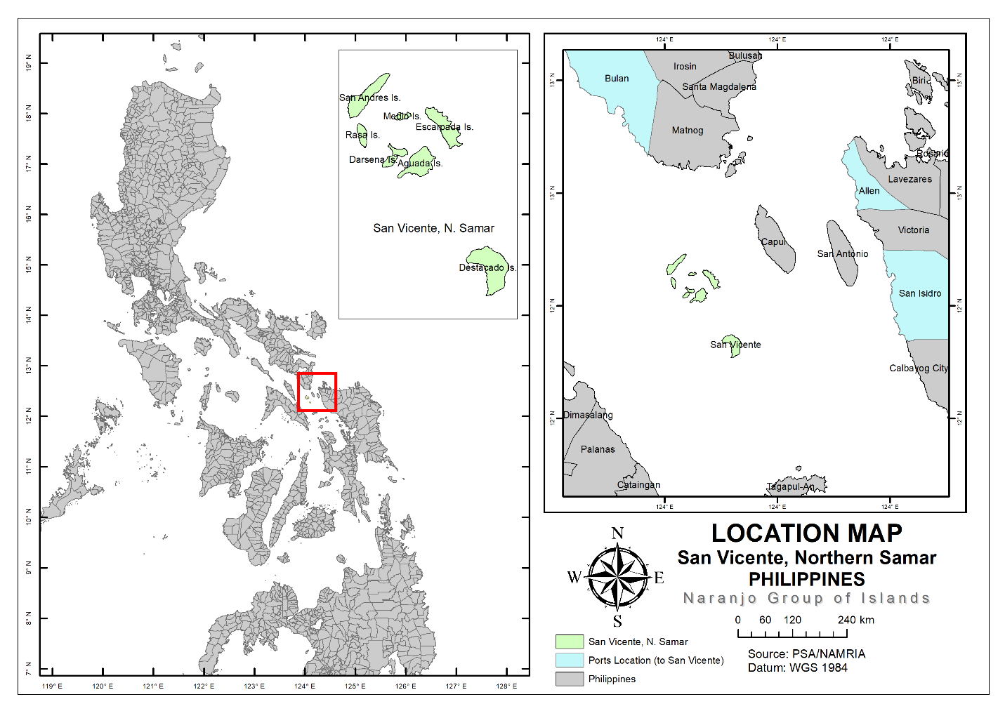
San Vicente, Northern Samar, an archipelagic municipality in Eastern Visayas, Philippines, is located between 12⁰15' to 12⁰24' north latitude and 124⁰0' to 124⁰7' east longitude (Figure 1). It covers a total land area of approximately 1,860 hectares (Municipality of San Vicente, Northern Samar Municipal Profile, 2017). The municipality consists of seven (7) small islands. Destacado Island is composed of three barangays, namely, Mongolbongol, Destacado, and Punta. Aguada, Darsena, and Escarpada Islands are political territories of Barangay Tarnate, Sila, and Sangputan, respectively. San Andres, Rasa, and Medio islands are part of Barangay Maragat (Municipality of San Vicente, Northern Samar Municipal Profile, 2017). The islands in San Vicente, Northern Samar, are collectively called the Naranjo Group of Islands. The island group is accessible from the ports of San Isidro, Northern Samar, Allen, Northern Samar, and Bulan, Sorsogon, wherein sea transportation is the only means of going to and coming from San Vicente, Northern Samar. Fishing and farming are the main livelihoods in San Vicente. The municipality has a fertile fishing ground for sardines, blue marlin, oriental bonito, and mackerel, among others. The municipality of San Vicente holds Panagat (a Cebuano and Waray-Waray term for fishing) Festival yearly to celebrate its bountiful sea harvest. Coconut is the predominant crop in the island group. Food and other resources in the island group are limited, making the municipality dependent on the mainland for the supply of food and other resources (Municipality of San Vicente, Northern Samar Comprehensive Development Plan, 2019-2023).
Construction of Small Island Spatial Accessibility Index (SISAI)
In this study, spatial accessibility generally refers to the "capacity of a location to be reached by or to reach different locations" (Rodrigue, 2013:304). Based on island accessibility studies, the following indicators were used to create a composite index of a small island's spatial accessibility: distance (Sunarti, 2018); the number of public vehicles available (Kavroudakis, Ioakeim, Phaedon, & Thanassis, 2019); one-day return trip (Cross & Nutley, 1999; Luis, 2002; Royle, 2001; Spilanis, Kezos, & Petsiote. 2012); daily accessibility (Cross & Nutley, 1999; Luis, 2002; Royle, 2001; Spilanis, Kezos, & Petsiote. 2012) (number of vehicles that travel per week). The number of trips (Cross & Nutley, 1999; Farrington, 2007; Karampela, Kezos, & Spilanis; 2014; Makkonen, Salonen, & Kajander, 2013) per week; total vehicle passenger capacity (Makkonen, Salonen, & Kajander, 2013; Spilanis, Kezos, & Petsiote, 2012) per week; and transport connectivity (Makkonen, Salonen, & Kajander, 2013; Spilanis, Kezos, & Petsiote, 2012) were also considered in measuring the spatial accessibility of San Vicente, Northern Samar. The 2018 transportation data from the Maritime Industry Authority (MARINA)-Region 8 was used in the study.
Distance could be measured by a straight line between the origin and the destination or its travel time (Makkonen, Salonen, & Kajander, 2013; Karampela, Kizos, & Spilanis, 2014.). In this study, the distances (km) were measured by drawing a straight line from an island's mass centroid to the mainland on a map (Köchy & Rydin, 1997; Weigelt & Kreft, 2013) using the proximity analysis in ArcGIS 10.5 software (Environmental Systems Research Institute, Redlands, California, CA, USA). The transport connectivity parameter represents the presence or absence of a direct transit from the point of origin to the destination (Mamun et al., 2013). Thus, the connectivity parameter takes the value of 1 if the transit directly connects origin i to destination j, 0.5 if it stops at other islands to pick up passengers, and 0 for islands not covered. Travel costs were not included in the index because of their variability through time (Karampela, Kizos, & Spilanis, 2014; Kavroudakis, Ioakeim, Phaedon, & Thanassis, 2019).
The spatial accessibility of the small islands with every mainland where they have spatial interaction was calculated. The scores were normalized between 0 and 1 to have comparative values (Han & Liu, 2018), wherein a score of zero signifies very low spatial accessibility, and 1 indicates very high spatial accessibility. The total spatial accessibility of the small islands was determined by calculating the average spatial accessibility index scores. Moreover, the island group is prone to extreme weather events. Under Article VI (G) of the Philippine Coast Guard Memorandum Circular (MC) No. 01-09 (A & C), series of 2014 Guidelines on Movement of Vessels During Heavy Weather, "vessels shall not sail when its point of origin or route or point of destination is within an applicable PSWS Sector where it is not allowed to sail based on the latest PAGASA weather bulletin." Thus, the weather condition was considered an external variable that affects the small islands' spatial accessibility. When there is an extreme weather event, the spatial accessibility score is multiplied by 0 and 1 if there is none.
Construction of Spatial Accessibility Problem Confrontation Index (SAPCI)
Problem confrontation refers to the assessment of the problems, constraints, or barriers (Ndamani & Watanabe, 2015) on the spatial accessibility of small islands. Focus groups and surveys were conducted to determine the spatial accessibility problems in the island group. About ten (10) to fifteen (15) islanders from each island barangay were asked to participate in the focus group. The results were transcribed verbatim, validated (Birt et al., 2016; Rudestam & Newton, 2014), and translated to English (Bailey, 2008; Fujita, 2009).
The focus group results (Mazur & Bennett, 2008) and related literature were used in constructing the survey instrument. A four-point Likert scale was used to measure the spatial accessibility problem of San Vicente, Northern Samar. The respondents were asked to grade their perceived spatial accessibility problems based on a 0–3 Likert scale wherein 0 means "not a problem," while 3 means "highly problematic." The formula (Uddin, Bokelmann, & Entsminger, 2014; Ndamani, 2016) for the computation of the Spatial Accessibility Problem Confrontation Index (SAPCI) is shown below:
$$ SAPCI = (P_h \times 3) + (P_m \times 2) + (P_l \times 1) + (P_n \times 0) $$
…where \(P_h\) is the number of respondents that confronted the problem as high, \(P_m\) is the number of respondents that confronted the problem as a moderate, \(P_l\) is the number of respondents that confronted the problem as low, and \(P_n\) is the number of respondents that confronted the problem as not at all. Moreover, the SAPCI scores were aggregated and normalized, wherein a score of zero signifies very low spatial accessibility problem confrontation, and 1 indicates very high spatial accessibility problem confrontation. Also, the frequency and purpose of travel to the mainland were asked during the survey.
The interview schedule was conducted between mid-December 2018 and March 2019, influenced by weather conditions, travel safety, and transport availability. Each island in San Vicente, Northern Samar, was considered one study area except for San Andres, Rasa, and Medio Island, which belong to one political unit – Barangay Maragat, thus were considered one study area. About 1333 households comprising 79% of the total household population were surveyed. The study initially intended a complete enumeration. However, it was logistically unfeasible due to the unavailability, refusal, incapacity to participate, e.g., deaf, or failure of the respondents to complete the survey.
Results and Discussion
Transport Availability and Characteristics
Sea transport is the only means of transport in the Naranjo Group of Islands. The accessibility of islands is commonly restricted by a boat as a mode of transport wherein the travel is less frequent and restricted by cost, tide, and weather conditions (Cross, 1996). The Naranjo Group of Islands is accessible in Bulan, Sorsogon, San Isidro, and Allen, Northern Samar, on schedule. Two registered passenger vehicles sail to Bulan, Sorsogon. Every Monday, one public vehicle leaves from Destacado Island and stops at Aguada and Escarpada Island to pick up passengers. Passengers from Darsena and San Andres, Rasa, and Medio need to travel to Aguada or Escarpada Island. The other passenger vehicle directly travels from Destacado Island to Bulan, Sorsogon, without stopping in any other islands in the group on Saturdays. Passengers from other islands who want to travel on Saturday to Bulan, Sorsogon, need to travel to Destacado Island or meet the vehicle in the sea.
Three passenger vehicles travel alternately to San Isidro, Northern Samar, from Monday to Saturday and return to Destacado Island on the same day (Table 1). The vehicle scheduled to travel to San Isidro does not travel to the other islands to pick up passengers. The islanders from Aguada, Darsena, Escarpada, San Andres, Rasa, and Medio Islands need to go to Destacado Island or occasionally ride with the fish buyer or hire a boatman for a special trip to Allen or San Isidro, Northern Samar. The three (3) passenger vehicles can accommodate about 219 passengers per week. It leaves Destacado Island at around 7:00 a.m. and leaves San Isidro, Northern Samar, around 2:00 p.m. Moreover, two (2) passenger vehicles travel once a week from Destacado Island to Allen, Northern Samar, and return to the island on the same day and can accommodate about 68 passengers per week.
| Island | Mainland | Distance to the mainland (km) | No. of public vehicles available | One day return trip (yes = 1, No = 0) | Daily accessibility (No. of vehicle/week) | No. of trips per week | Transport connectivity | Total vehicle carrying capacity/week | Distance to the nearest pick-up point (km) |
|---|---|---|---|---|---|---|---|---|---|
| Destacado | Bulan, Sorsogon | 48.99 | 2 | 0 | 2 | 2 | 1 | 55 | 0 |
| Aguada | 39.64 | 1 | 0 | 1 | 1 | 0.5 | 35 | 0 | |
| Darsena | 38.53 | 0 | 0 | 0 | 0 | 0 | 0 | 1.97 | |
| Escarpada | 37.78 | 1 | 0 | 1 | 1 | 0.5 | 35 | 0 | |
| San Andres, Rasa, and Medio | 35.22 | 0 | 0 | 0 | 0 | 0 | 0 | 5.02 | |
| Destacado | Allen, Northern Samar | 33.94 | 2 | 1 | 2 | 2 | 1 | 68 | 0 |
| Aguada | 32.56 | 0 | 0 | 0 | 0 | 0 | 0 | 9.57 | |
| Darsena | 33.87 | 0 | 0 | 0 | 0 | 0 | 0 | 11.13 | |
| Escarpada | 29.5 | 0 | 0 | 0 | 0 | 0 | 0 | 11.26 | |
| San Andres, Rasa, and Medio | 33.55 | 0 | 0 | 0 | 0 | 0 | 0 | 14.43 | |
| Destacado | San Isidro, Northern Samar | 32.97 | 3 | 1 | 6 | 6 | 1 | 219 | 0 |
| Aguada | 35.52 | 0 | 0 | 0 | 0 | 0 | 0 | 9.57 | |
| Darsena | 37.29 | 0 | 0 | 0 | 0 | 0 | 0 | 11.13 | |
| Escarpada | 39.19 | 0 | 0 | 0 | 0 | 0 | 0 | 11.26 | |
| San Andres, Rasa, and Medio | 40.64 | 0 | 0 | 0 | 0 | 0 | 0 | 14.43 | |
Distance
Aguada and Escarpada Island are approximately 40 and 38 kilometers far from Bulan, Sorsogon, respectively. Darsena and San Andres Island are approximately 39 and 34 kilometers far from Bulan, Sorsogon, respectively. Darsena Island is approximately 1.97 kilometers far from Aguada, while San Andres is approximately 6.49-kilometer distant. Aguada Island is approximately 9.57 kilometers away from Destacado Island, while San Andres is about 16.05 kilometers. Darsena and Escarpada Island are approximately 11 kilometers far from Destacado Island (Table 1). The travel time from Destacado Island to Bulan, Sorsogon, and vice-versa is approximately three (3) hours (MARINA-Region 8, 2018). The passengers to Bulan who intend to travel back need to stay in lodging houses or on the vessel for a night in Bulan, Sorsogon because their transport travels back only on the next day. Luis (2002) stated that the absence of a return trip within the day increases the cost, e.g., staying in a hotel for a night and losing part of the next working day. Also, the islanders can occasionally ride with the fish buyers or hire a boatman for a special trip going to Bulan, Sorsogon. The travel time from Destacado Island to Allen and San Isidro, Northern Samar, and vice versa is approximately two (2) to three (3) hours (MARINA-Region 8, 2018). The study suggests that the vehicle leaves the island earlier than its current schedule, especially for those with transactions and must travel to other municipalities, provinces, or regions.
Small Island Spatial Accessibility Index
Based on the spatial accessibility characteristics of the small islands, the spatial accessibility index of the small islands was calculated (Table 2). The total spatial accessibility index score showed that Destacado Island is the most accessible island in the group, with an index score of 0.744. The availability of public transport on Destacado Island made the island the most accessible island in the group and gave its residents more travel destination preferences (Fig. 2a). Escarpada Island has a spatial accessibility index score of 0.222, while Aguada Island has an index score of 0.217. Their distance to the mainland influences the slight difference in the index score between Aguada Island and Escarpada Island. Darsena Island has a spatial accessibility index score of .095, while San Andres, Rasa, and Medio Island have the lowest score of .045. Darsena and San Andres, Rasa, and Medio Island ranked the lowest because of the unavailability of public transport in their areas.
| Island | Spatial Accessibility | Spatial Accessibility Composite Index | ||
|---|---|---|---|---|
| Bulan | Allen | San Isidro | ||
| Destacado | 0.571 | 0.696 | 0.964 | 0.744 |
| Aguada | 0.446 | 0.081 | 0.126 | 0.217 |
| Darsena | 0.171 | 0.0312 | 0.083 | 0.095 |
| Escarpada | 0.462 | 0.150 | 0.051 | 0.222 |
| San Andres, Rasa, and Medio | 0.125 | 0.011 | 0.000 | 0.045 |
The results showed that both the distance and availability of public transport are significant in assessing island accessibility. Karampela, Kizos, and Spilanis (2014) stated that geographical distance is not determining accessibility; however, Taglioni (2011) stated that distance is necessary to understand remoteness, and it signifies the need for transportation. Surya (2015) also found distance and transportation availability significant in determining how islanders' demands for goods and services are satisfied. The distance from the mainland and islands where the vehicles are available reflects the isolation (Kostopoulou, 1995) of the islands and the need for transport. A similar condition was found by Hidalgo et al. (2015) in Achao, one of the islands in the Quinchao Archipelago System in Chile, wherein traveling to and from Achao Island is strongly influenced, among others, by the availability of transport in the area. Furthermore, the mainland's attractiveness also influences the travel of the islanders. Bulan, Sorsogon is a first-class municipality (PSA, 2019a), while San Isidro, Northern Samar, and Allen, Northern Samar, are classified as fourth- and fifth-class municipalities, respectively (PSA, 2019b).
Moreover, environmental factors, e.g., extreme weather events, affect the spatial accessibility of small islands for sea vessels in the Philippines are "not allowed to sail when its point of origin or route or point of destination is within an applicable Public Storm Warning Signal (PSWS) Sector where it is not allowed to sail based on the latest Philippine Atmospheric, Geophysical, and Astronomical Services Administration (PAGASA) weather bulletin (Philippine Coast Guard Memorandum Circular (MC) No. 01-09 (A & C), Article VI (G), s. 2014)." Data from PAGASA – Catarman, Northern Samar (2011-2018) show that the province of Northern Samar, of where the island group is a part, is affected by an average number of two (2) tropical cyclones (center within 200 km. from Catarman) per year. About three (3) typhoons pass Sorsogon every two years (Mias-Mamonong & Flores, 2010). Di Piazza, Di Piazza, and Pearthree (2007) stated that if the sea conditions are unfavorable, the island is inaccessible no matter how short the distance. The sea serves as the source of the islands' connectedness (Mehmood, 2009) and, at the same time, is a significant barrier to accessing services, especially during extreme weather events. The FGD showed that when there is an extreme weather event, the island group is inaccessible for a week or may even take a month (P5Fg3, P2FG6). The spatial accessibility of small islands is significantly affected by extreme weather events, which may disrupt the transport of essential goods and services to and from island communities (Mendas, 2015).
Frequency of Travel to Mainland
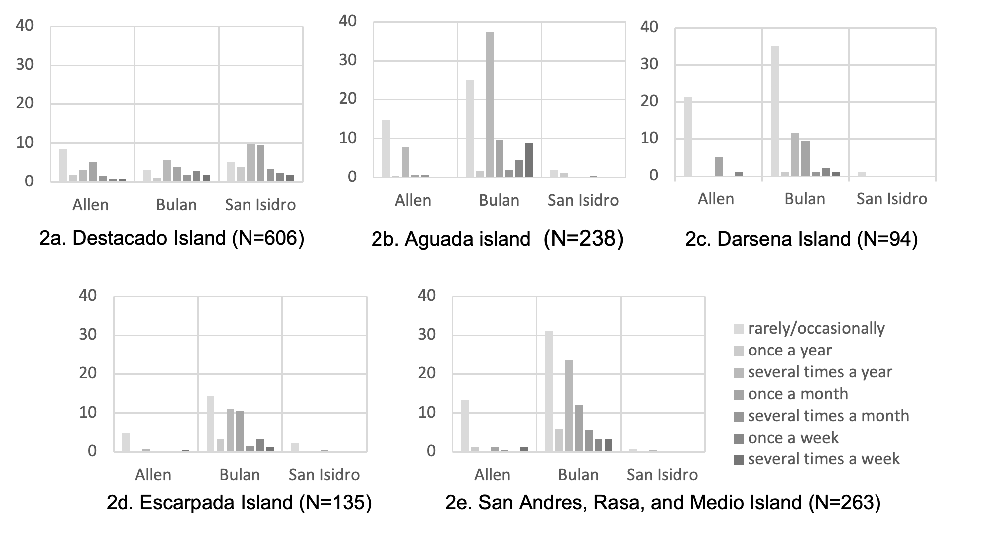
The households in Destacado Island (2a) travel the most to San Isidro, Northern Samar (36%), wherein about 15% travel to San Isidro from several times a week to once a month. About 26% of the households who travel to San Isidro buy goods, and about 12% sell their products (e.g., fish and copra). Moreover, the households in Destacado Island frequently travel to Allen, Northern Samar, compared with other households in the island group, wherein about 8% travel from several times a week to once a month. About 20% of households who travel to Allen, Northern Samar, buy things they need, and about 8% sell their catch or copra.
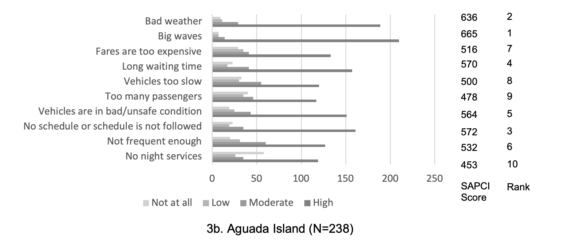
Most of the households in Aguada (90%), Darsena (54%), Escarpada (86%), San Andres, Rasa, and Medio Island (92%) prefer to travel to Bulan to buy goods and sell their products The households in Aguada Island (25%) frequently travels to Bulan Sorsogon from several times a week to once a month, followed by the households in San Andres, Rasa, and Medio Islands (24%), and Escarpada Island (17%). Despite the low accessibility of San Andres, Rasa, and Medio, the households from these islands travel more to Bulan, Sorsogon than the households in Escarpada and Darsena Island. The households from these islands prefer to travel to Bulan, Sorsogon due to the availability of transport near or within their area (Fig. 2b, 2c, 2d, 2e), distance, and the availability of desired goods and services.
Hope (2008) stated that travel demand is primarily a derived demand for other goods and services from the mainland. The households in the island group travel to the mainland to access goods, health services, and education. Moreover, the farmers, copra buyers, and fish buyers in the island group sell their products on the mainland.
Problem Confrontation
Spatial inaccessibility is one of the islanders' central problems (Cross, 1996). Problem confrontation is the assessment of the problems, constraints, or barriers of the small islands' spatial accessibility. According to participant P2Fg2, transportation is a big problem because they live on an island and need to travel by sea. The islanders expressed their concerns about the spatial accessibility of the Naranjo Group of Islands, for sea transport is the only means that connects the island group with the mainland, and their vehicles are limited.
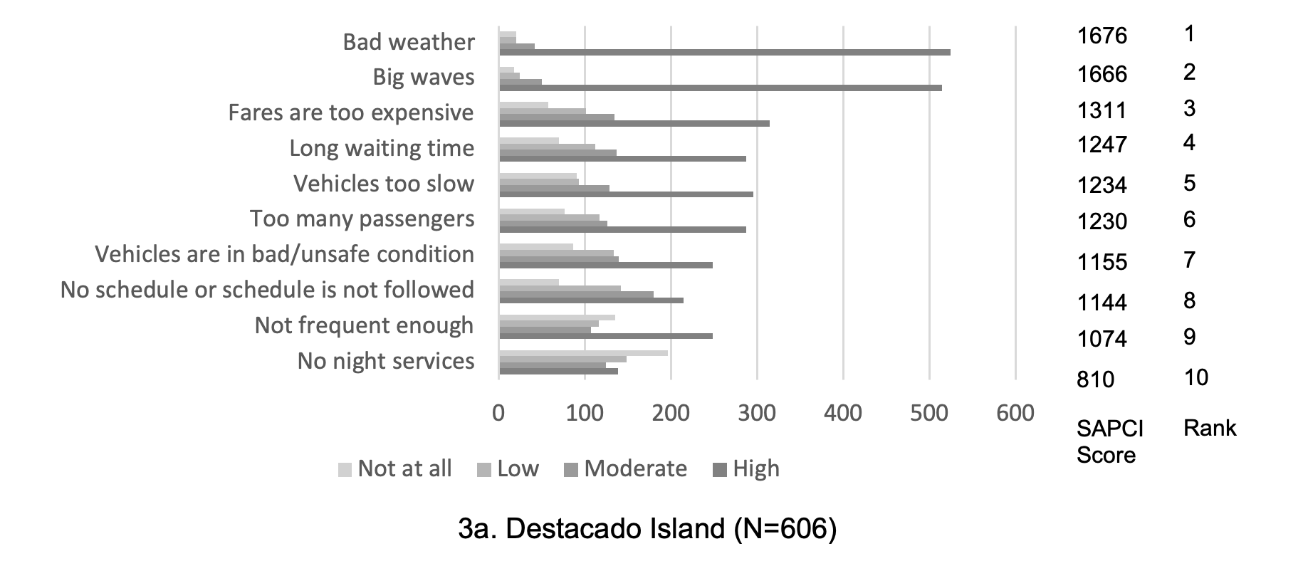
All respondents considered the big waves and bad weather their first two main spatial accessibility problems in the Naranjo Group of Island (Fig. 3). Bad weather and rough seas make the accessibility problem worse (Spilanis, Kondili, & Gryllaki, 2003). Extreme weather events can damage or destroy transport (Burholt, Scharf, & Walsh, 2013; Food and Agriculture Organization of the United Nations, 2008) and the delivery of essential goods and services to and from island communities (Burholt, Scharf, & Walsh, 2013; Mendas, 2015). Many dangers lurk in the Philippine seas, e.g., typhoons, storm surges, and others, but the sea is a significant element of Filipinos' life. Thus, they must live with the threats coming from sea waters (Bouquet, 2017). The Naranjo Group of Islands lies within the end portion of the San Bernardino Strait (United States Government, 2017).
Some FGD participants recalled their near-death experiences and their household members' when traveling by sea to other places and back to the island.
"We were on our way to Manila. We encountered huge waves, so big that they almost covered our boat. Yolanda! That was Typhoon Yolanda. It was approaching on November 8. We nearly sank. We were going to Allen. The vessel was swaying (P2Fg3)."
"We can sometimes experience that upon arriving in Bulan, and there is low pressure. Occasionally, we are caught by big waves in the middle of the sea, and there is a tendency for the tarps to be flipped. It is difficult when you are caught in a squall because it was my worst experience of going to Bulan. Sometimes the waves are big, even bigger than a house. When I was studying in college, I experienced waves that were bigger than a house (P9Fg4)."
"When I was studying in Bulan, and when the waves were big, they tied me up. For example, if we sank, I will not be carried far from the boat because I am tied to it (P3Fg4)."
When sea travel is not favorable, transportation to the mainland is most likely to be disrupted. A gale warning, a meteorological message, is issued to warn about the occurrence or expected occurrence of an average wind speed ranging from 34 to 47 knots or a wind force of 8 or 9 on the Beaufort scale (World Meteorological Organization, 2005). According to the focus group participants, there is no transport when there is a gale warning (P1Fg3; P11Fg7; P13Fg7). Moreover, when the Philippine Atmospheric, Geophysical, and Astronomical Services Administration (PAGASA) issues a Public Storm Warning Signal (PSWS), vessels are prohibited from sailing if the said warning and prohibition cover their point of origin or point of destination (Article VI, Philippine Coast Guard Memorandum Circular (MC) No. 01-09, series of 2014).
The participants warned that islanders would be asked to return when they travel despite the advisory immediately.
"Now, if there is a signal number one, do not insist on going to the mainland because you will be sent back immediately (P1Fg3)."
"There is no transport here when there is a typhoon. Even if the typhoon is just approaching, and some will insist on going to the mainland, they will be sent back without any cargo. Not all are aware of this, but some are. That is why we have a stock of food (P13Fg7)."
Disruption of transport in the island group would mean isolation, food shortage, depletion of goods, loss of income, and hunger, among others. The Food and Agriculture Organization of the United Nations (2008) stated that food availability and people's accessibility to food are among the first to be affected by extreme weather events, especially in island communities.
Some of the participants narrated the effect of transport disruption on the island.
"If there is no transportation, the effect is hunger because we do not have products. It took several days that we did not have transport because of a typhoon – weeks (P4Fg2)."
"The transportation on the island is disrupted during extreme weather events from 7 to 14 days or even nearly a month (P5Fg3)."
During calamities, the basic needs and primary commodities are most likely to be depleted due to transport disruption. Some participants stated that the island group runs out of food and other resources if there is no transportation for several days due to bad weather and big waves (P13Fg1, P2FG6).
"I could not buy rice anymore because we ran out of local supplies. I did not know what to do because my mother was sickly. Since there was sticky rice for sale, that was the one that I cooked as porridge. I wanted to buy sugar, but there was no more sugar to buy. When the waves are strong for a week, there is no more rice for sale, no more food (P13Fg1)."
The continued transport of resources such as food and other resources is vital (Cross & Nutley, 1999; Forni et al., 2017) to sustain the existence and survival of small island communities with limited resources. The stacking of food and other goods is critical in supporting the islanders' needs until it is safe again to access resources from the mainland. The island group has a limited agricultural area for food production for copra is its primary agricultural product. Food stacking was practiced in Rapu-Rapu Island, Albay, Philippines, wherein the local government built a warehouse to ensure that goods could be stockpiled safely in preparation against extreme weather events and travel disruption (Staff of Christian Aid et al. 2011). The construction of a boat shelter in the island group is also critical to protect the vessels from being destroyed during extreme weather and ensure transport continuity.
The study further recommends the government's support for small businesses in the island group to increase capital and the number of businesses on the island to sustain the food supply, reduce travel to the mainland to obtain goods, and increase the islanders' financial capacity. Many of the businesses in the island group are sari-sari stores (Business Permit and Licensing Office, San Vicente, Northern Samar, 2019). A sari-sari store is a small-scale store prevalent in the Philippines that provides daily necessities, food, and drinks (Funahashi, 2013). McReynolds (2014) stated that stores could make more significant economic contributions to island communities. The availability of local stores on the island is crucial to sustaining the residents' needs and minimizing travel and dependence on the mainland for food and other supplies (Cross & Nutley, 1999).
The transport to the mainland from Darsena, Aguada, Escarpada, San Andres, Medio, and Rasa Islands is infrequent, but the schedule is rarely unfollowed. The households from Darsena (Fig. 3c) and Escarpada (Fig.3) ranked them as their fourth and fifth spatial accessibility problems, respectively. The households in Aguada (Fig. 3b) and San Andres, Rasa, and Medio Island (Fig. 3e) consider infrequent transport as their fifth and third problem, respectively, and the irregularity of schedule their sixth problem.
The FGD participants from the island group stated that the transportation going to Bulan, Sorsogon, is sometimes not followed due to bad weather, unsafe condition of the vehicle, and other similar circumstances. One participant lamented the need for daily transport to the mainland, not just on Destacado Island.
"For me, there must be daily transportation. The first reason is the food, those who are sick, those with important transactions in Tacloban or Catarman, especially Catarman and Tacloban, because we are under Northern Samar (P4Fg7)."
Vehicles in bad and unsafe conditions were considered as the third problem by the respondents in Darsena (Fig. 3c), Escarpada (Fig. 3d), and San Andres, Rasa, and Medio Island (Fig. 3e) for it denote the absence of transportation or difficulty in traveling. One participant shared how terrified she was when the outrigger of their boat loosened.
"It was scary. The waves were big. We encountered big waves during our travel. I thought I was going to die in the middle of the sea. The outrigger was loosened (P5Fg1)."
Households from Destacado Island (3a) and San Andres, Rasa, and Medio Island (3e) consider the fares as their third and fourth spatial accessibility problems, respectively. The one-way fare to the mainland (from San Vicente to Allen and San Isidro, Northern Samar, and Bulan, Sorsogon, and vice versa) ranges from 120 to 200 pesos. Hope (2008) suggested that transport must be affordable, wherein the fare must be within reach of the average islander. If the fares are expensive, the islanders' travel to access services may be lessened. The absence of enough transportation made the islanders sometimes hire private boats in traveling to the mainland, which is costly. Transport is the most expensive for islands, especially for those not served with public transport. During emergencies, the islanders are forced to hire a boat to the mainland. The cost of transportation may leave islands isolated to some degree (Deschenes & Chertow, 2004). Spilanis et al. (2012) stated that when a service is unavailable on the island, the cost and the time required to access it is disproportionally high.
The availability of fast and efficient transport to the mainland during emergencies is critical, especially for small islands with limited healthcare services. P9Fg5, a midwife, narrated that they refer their patients to the mainland, which is far. This made them clamor for a better and faster mode of transport and emphasized the need for a sea ambulance in the island barangays that can be used during emergencies. During the conduct of the study, only Barangay Maragat has a sea ambulance.
"…we refer patients, especially when there is a pregnant woman with a breech presentation inside the womb, that we have to travel in the early morning or at night to Allen or Bulan or other places. But our direct referral is Allen, and it is far (P9Fg5)."
Moreover, the availability of fast and efficient transport to improve the accessibility of the islands is necessary to ensure timely access to healthcare services on the mainland. Kavroudakis and Penteridou (2017) found a similar finding wherein the availability of fast transport in remote and peripheral islands of the Aegean Sea was vital in accessing specialized hospitals in mainland Greece, especially during emergency cases. Cross and Nutley (1999) also found that during emergency cases and expectant mothers, the small island communities of Western Ireland require transport to mainland hospitals.
Small Island Problem Confrontation Index (SAPCI)
Based on the problem confrontation of the households in San Vicente, Northern Samar, the small island problem confrontation index was calculated. As shown in Figure 4, the households in the island group were primarily concerned about the big waves, bad weather, unsafe conditions of the vehicles, and unfollowed schedule, with an index score of 1.0, 0.96, 0.55, 0.49, respectively. The households in the island group were also concerned about the long waiting time (0.46) and infrequent travel (0.45). However, none of them was worried about the absence of night travel, except during emergencies. The results imply that the households in the island group were mainly concerned about travel disruption to the mainland, especially when there is an extreme weather event. Disruption of travel may result in isolation, food shortage, goods depletion, hunger, loss of income, or loss of life, especially for those that cannot access health services on time during emergencies. The availability and access of all islanders to public transport is critical in safeguarding their continued access to goods and services that are vital to their existence, survival, and well-being.
Furthermore, the households on Destacado Island confronted the spatial accessibility as moderately problematic, with an average SAPCI score of 0.51 despite being the most accessible island in the group. On the other hand, San Andres, Rasa, and Medio Island have very low spatial accessibility, but their households confront the spatial accessibility problem low, with an average SAPCI score of 0.40. The availability of private boats in San Andres, Rasa, and Medio Island that travel to the mainland to deliver and access goods and services improves the spatial accessibility of the area. Moreover, the availability of stores and close social networks where households can ask their friends, relatives, neighbors, and boatmen to buy goods on the mainland for free or for a minimal fee may lessen the need for households to travel to the mainland. The results support the thesis that the accessibility of small islands has a spatial as well as a social aspect. The study suggests further research on the social facet of small islands' accessibility and how the social and spatial aspects of island accessibility intertwine.
The policymakers can use the study results in their transport planning and as bases for conducting a transportation feasibility study to improve the spatial accessibility of the island group. The provision of transport services in small islands is expected to play a vital role in shaping the island economy and quality of life (Cross & Nutley, 1999). Spatial accessibility promotes island communities' development by reducing isolation and facilitating access to employment, healthcare, education, and social activities (Currie & Falconer, 2014). Cost-effective sea transport is a prerequisite for islands' social and economic development (Spilanis, Kondili, & Gryllaki, 2003).
Conclusion and Recommendation
Spatial accessibility is crucial to small island communities' resilience as it serves as their lifeline that sustains their existence and survival. However, studies that focus on the transport availability and characteristics as measures of the spatial accessibility of small islands are lacking. A Small Island Spatial Accessibility Index (SISAI) was developed to determine the level of spatial accessibility of the small islands in the Philippines, wherein the distance (km) and public transport characteristics were considered. The number of public vehicles available, availability of one-day return trip (presence/absence), number of vehicles that travel per week, number of trips per week, total vehicle passenger capacity per week, and transport connectivity were used as indicators. Destacado Island was the most accessible island primarily due to transport availability in the area. Darsena and San Andres, Rasa, and Medio Island ranked the lowest due to the absence of public transport in their area. Distance and transport availability were both found critical in measuring spatial accessibility. Distance reflects the isolation and transport needs, while the transport characteristics describe the condition and availability of transport in the area.
Moreover, a Spatial Accessibility Problem Confrontation Index (SAPCI) was constructed to determine the spatial accessibility problems of the islanders. Results showed that disruption of the spatial accessibility of the island group due to big waves, bad weather, unsafe condition of the vehicles, and unfollowed schedule were the four main problems that concern households. Thus, stacking food and providing a storage facility or warehouse is critical to ensure that goods are stored safely to sustain the community's needs, especially when extreme weather and travel disruption are expected. The government's support for small businesses is also essential to increase capital, the number of businesses on the island to sustain the food supply, reduce travel to the mainland to obtain goods, and increase the islanders' financial capacity. The study also recommends the provision of a sea ambulance that can be used during emergencies. The availability of sea ambulances on the island is essential to ensure the safety and timely access to health services of the islanders on the mainland. The construction of a boat shelter in the island group is also critical to protect the vessels during extreme weather and ensure transport continuity. Policymakers can use the results of SAPCI in their transport planning and the conduct of transportation feasibility studies to enable the economical transport of people, goods, and services and ensure that all islands in the group have access to transport. Moreover, the study recommends further studies on the relationship between small island spatial accessibility and resilience and how the spatial and social aspects of small island accessibility intertwine.
Acknowledgments
The authors are grateful to the Philippine Commission on Higher Education for the dissertation grant and the Philippine Maritime Industry Authority (Region 8) for providing the transportation data. The authors also wish to express heartfelt thanks to the reviewers for their helpful comments and suggestions.
References
- Asian Development Bank., 2012. Philippines: Transport sector assessment, strategy, and road map. Mandaluyong City, Philippines: Asian Development Bank, 2012. Available online: https://www.adb.org/sites/default/files/institutional-document/33700/files/philippines-transport-assessment.pdf. (Accessed 7 April 2019).
- Bailey, J., 2008. First steps in qualitative data analysis: transcribing. Family practice, 25(2), 127-131.
- Boquet, Y., 2017. The Philippine Archipelago (p. 321). Cham: Springer.
- Business Permit and Licensing Office, San Vicente, Northern Samar. 2019. Registered Businesses in San Vicente, Northern Samar.
- Birt, L., Scott, S., Cavers, D., Campbell, C., Walter, F. M., 2016. Member checking: a tool to enhance trustworthiness or merely a nod to validation? Qualitative Health Research. DOI: 10.1177/1049732316654870.
- Bowen, T., 2015. Social protection and disaster risk management in the Philippines: the case of typhoon Yolanda (Haiyan). The World Bank.
- Burholt, V., Scharf, T., Walsh, K., 2013. Imagery and imaginary of islander identity: Older people and migration in Irish small-island communities. Journal of Rural Studies, 31, 1-12.
- Cinco, T.A., de Guzman, R.G., Ortiz, A.M.D., Delfino, R.J.P., Lasco, R.D., Hilario, F.D., Juanillo, E.L., Barba, R., Ares, E.D., 2016. Observed trends and impacts of tropical cyclones in the Philippines. International Journal of Climatology, 36(14), pp.4638-4650.
- Cross, M. D., 1996. Service Availability and Development among Ireland's Island Communities—the Implications for Population Stability. Irish Geography, 29(1), 13-26.
- Cross, M., Nutley, S., 1999. Insularity and Accessibility: The Small Island Communities of Western Ireland. Journal of Rural Studies, Vol. 15, No. 3, pp. 317-330.
- Curl, A., 2018. The importance of understanding perceptions of accessibility when addressing transport equity. Journal of Transport and Land Use, 11(1), 1147-1162.
- Currie, C., Falconer, P., 2014. Maintaining sustainable island destinations in Scotland: The role of the transport–tourism relationship. Journal of Destination Marketing & Management, 3(3), 162-172.
- Deschenes, P. J., Chertow, M., 2004. An island approach to industrial ecology: towards sustainability in the island context. Journal of Environmental Planning and Management, 47(2), 201-217.
- Di Piazza, A., Di Piazza, P., Pearthree, E., 2007. Sailing virtual canoes across Oceania: Revisiting island accessibility. Journal of Archaeological Science, 34(8), 1219-1225.
- Eckstein, D., Künzel, V., Schäfer, L., 2017. Global Climate Risk Index 2018. Germanwatch. Available online: https://germanwatch.org/sites/germanwatch.org/files/publication/20432.pdf. (Accessed 28 November 2018).
- Eurisles, 1996. Systems of transport in the islands. Paris, L'Harmattan.
- Farrington, J. H., 2007. The new narrative of accessibility: Its potential contribution to discourses in (transport) geography. Journal of Transport Geography, 15, 319–330.
- Food and Agriculture Organizations of the United Nations., 2008. Climate Change and Food Security In Pacific Island Countries. Available online: http://www.fao.org/3/i0530e/i0530e.pdf (Accessed 15 May 2020).
- Forni, M S., Bennett, C.R., Dos Anjos Ribeiro Cordeiro, M.J., Michaels, S.D., Rozenberg, J., Pedroso, F. F. F., 2017. Climate and disaster resilient transport in small island developing states: a call for action (English). Washington, D.C. World Bank Group. Available online: http://documents.worldbank.org/curated/en/879491510323939763/Climate-and-disaster-resilient-transport-in-small-island-developing-states-a-call-for-action (Accessed 7 April 2019).
- Fujita, Y., 2009. Cultural migrants from Japan: Youth, media, and migration in New York and London. Lexington Books.
- Funahashi, T., 2013. Distribution and consumption in the base of the pyramid (BoP) market: The case of sari-sari stores in the Philippines. 経営論集, 60(4), 211-223.
- Han, J., Liu, J., 2018. Urban spatial interaction analysis using inter-city transport big data: a case study of the Yangtze River Delta urban agglomeration of China. Sustainability, 10(12), 4459.
- Hidalgo, C., Ther, F., Saavedra, G., & Díaz, A., 2015. Affordance of landscapes and economic socio-spatial networks in the Quinchao archipelago, Chile: a contribution to landscape research and island studies. Island Studies Journal, 10(1).
- Hope, K., 2008. The Inter-Island Transport System. 40th Annual Monetary Studies Conference Eastern Caribbean Central Bank 11-14 November 2008. Available online: https://www.researchgate.net/publication/322100902_The_Inter-Island_Transport_System (Accessed 6 April 2019).
- Karampela, S., Kizos, T., Spilanis, I., 2014. Accessibility of islands: towards a new geography based on transportation modes and choices. Island Studies Journal, 9(2).
- Kavroudakis, D., Penteridou, Z. M., 2017. Geographical Analysis of Emergency Evacuations in the Aegean Sea: Towards the Utilization of Big Data Analytics. In Smart Cities in the Mediterranean (pp. 313-331). Springer, Cham.
- Kavroudakis, D., Polydoropoulos, I., Kyriakidis, P., Kizos, T., 2019. Spatial patterns of accessibility between islands of the North and South Aegean regions and Attica. In The Practice of Spatial Analysis (pp. 85-115). Springer, Cham.
- Kostopoulou, S., 1995. Transport Networks and Insular Isolation. In Overcoming Isolation (pp. 235-253). Springer, Berlin, Heidelberg.
- Köchy, M., Rydin, H., 1997. Biogeography of vascular plants on habitat islands, peninsulas and mainlands in an eascentral Swedish agricultural landscape. Nordic Journal of Botany, 17(2), 215-223.
- Lazrus, H., 2012. Sea Change: Island Communities and Climate Change. Annual Review of Anthropology. DOI. 10.1146/annurev-anthro-092611-145730.
- Luis, J., 2002. Temporal accessibility in archipelagos: inter-island shipping in the Canary Islands, Journal of Transport Geography, Volume 10, Issue 3, 2002, Pages 231-239, https://doi.org/10.1016/S0966-6923(02)00014-5.
- Makkonen, T., Salonen, M., Kajander, S., 2013. Island accessibility challenges: Rural transport in the Finnish archipelago. European Journal of Transport and Infrastructure Research, 13(4).
- Mamun, S. A., Lownes, N. E., Osleeb, J. P., Bertolaccini, K., 2013. A method to define public transit opportunity space. Journal of Transport Geography, 28, 144-154.
- Maritime Industry Authority (MARINA) - Region 8. 2018. Transportation Data. Tacloban City, Philippines.
- Mazur, K., Bennett, J. W., 2008. Using focus groups to design a choice modelling questionnaire for estimating natural resource management benefits in NSW (No. 448-2016-33931).
- McReynolds, S. A., 2014. Community sustainability in the year-round islands of Maine. Island Studies Journal, 9(1), 79-102.
- Mehmood, Α., 2009. Understanding spatial development and interactions in small islands. Proceedings of Annual Regional Studies Association Conference. Understanding and shaping regions: spatial, social, economic futures, April 6-8, 2009, Leuven, Belgium, 1-22.
- Mendas, Z., 2015. Tracing socio-economic impact of ferry provision in Zadar Island archipelago. Journal of Marine and Island Cultures, 4(1), 10-26.
- Mias-Mamonong, A., Flores, Y., 2010. Sorsogon city climate change vulnerability assessment. United Nations Human Settlements Programme (UNHABITAT) Philippines.
- Municipality of San Vicente, Northern Samar., 2019-2023. Comprehensive Development Plan.
- Municipality of San Vicente, Northern Samar., 2017. Municipal Profile of San Vicente, Northern Samar.
- Ndamani, F., Watanabe, T., 2015. Farmers' perceptions about adaptation practices to climate change and barriers to adaptation: A micro-level study in Ghana. Water, 7(9), 4593-4604.
- Ndamani, F., 2016. Climate Change Perceptions and Adaptation in Agriculture: a Study of Rural Ghana modulation. Doctoral dissertation: Graduate School of Engineering Kochi University of Technology. Available online: https://www.kochi-tech.ac.jp/english/admission/img/4_Climate%20Change%20Perceptions%20and%20Adaptaion%20in%20Agriculture%20a%20Study%20of%20Rural%20Ghana%20modulation.pdf. (Accessed 7 April 2019).
- Philippine Atmospheric, Geophysical, and Astronomical Services Administration (PAGASA) – Catarman, Northern Samar. Tropical Cyclones Affecting Northern Samar (center within 200 km. from Catarman)., 1970 – 2018.
- Philippine Coast Guard Memorandum Circular No. 01-09, s. 2014., 2014. Guidelines on Movement of Vessels During Heavy Weather. Available online: http://www.coastguard.gov.ph/index.php/memorandums/12-mc/133-memorandum-circular-no-01-09-guidelines-on-movement-of-vessels-during-heavy-weather (Accessed 28 April 2014).
- Philippine Statistics Authority (PSA)., 2019a. Philippine Standard Geographic Code (PSGC). Available online: https://psa.gov.ph/classification/psgc/?q=psgc/citimuni/056200000. (Accessed on 28 March 2020).
- Philippine Statistics Authority (PSA)., 2019b. Philippine Standard Geographic Code (PSGC). Available online: https://psa.gov.ph/classification/psgc/?q=psgc/municipalities&page=41. (Accessed on 28 March 2020).
- Pungetti, G., 2012. Islands, culture, landscape and seascape. Journal of Marine and Island Cultures, 1(2), 51-54.
- Republic Act No. 9458., 2007. An Act Declaring the Island-Towns Of Biri, Capul, San Antonio and San Vicente, All In The Province Of Northern Samar As Eco-Tourism Zones. Available online https://www.officialgazette.gov.ph/2007/05/15/republic-act-no-9458/ (Accessed 24 May 2019).
- Royle, S.A., 2001. A Geography of Islands: Small Island Insularity, London, Routledge.
- Rodrigue, J., 2013. The Geography of Transport Systems. 3rd ed. New York: Routledge.
- Rudestam, K. E., Newton, R. R., 2014. Surviving your dissertation: A comprehensive guide to content and process. Sage Publications.
- Spilanis, I., Kondili, J., Gryllaki, S., 2003, November. Measuring the attractiveness of small islands. A tool for sustainability. In International conference on sustainability indicators. Available online https://www.researchgate.net/profile/Ioannis_Spilanis/publication/239533264_MEASURING_THE_ATTRACTIVENESS_OF_SMALL_ISLANDS_A_TOOL_FOR_SUSTAINABILITY/links/02e7e529746b273cf1000000/MEASURING-THE-ATTRACTIVENESS-OF-SMALL-ISLANDS-A-TOOL-FOR-SUSTAINABILITY.pdf (Accessed 6 June 2020).
- Spilanis, I., T. Kezos, Petsiote, P., 2012. Accessibility of Peripheral Regions: Evidence from Aegean Islands (Greece). Island Studies Journal, Vol. 7, No. 2, 2012, pp. 199-214.
- Staff of Christian Aid, Coastal Core Sorsogon (CCS), Marinduque Council for Environmental Concerns (Macec), Social Action Center Northern Quezon (SAC-Northern Quezon)., 2011. A Voyage to Disaster Resilience in Small Islands: A Guide for Local Leaders. Quezon City, Philippines: Christian Aid Philippine Office, p. 1-3.
- Sunarti, S. 2018, February. Transportation Limitation Access to the Small Islands (Case Study: Banggai Laut Regency). In IOP Conference Series: Earth and Environmental Science (Vol. 123, No. 1, p. 012018). IOP Publishing.
- Surya, B., 2015. Spatial Interaction Pattern and the Process of City Activity Formation System (Case Study, Ternate, Tidore Archipelago and Sofifi City of North of Maluku). Research Journal of Applied Sciences, 10(12), 880-892.
- Taglioni, F., 2011. Insularity, political status and small insular spaces. Available online:https://hal.archives-ouvertes.fr/hal-00686053/file/f._Taglioni_Shima_v5n2_45-67.pdf. (Accessed 22 June 2020).
- Uddin, M. N., Bokelmann, W., Entsminger, J. S., 2014. Factors affecting farmers' adaptation strategies to environmental degradation and climate change effects: A farm level study in Bangladesh. Climate, 2(4), 223-241.
- United Nations., 2014. Closing The Distance Partnerships for sustainable and resilient transport systems in SIDS. Available online:
https://sustainabledevelopment.un.org/content/documents/2295(UNCTAD,%202015)%20Closing%20the%20Distance%20-%20partnerships%20for%20sustainable%20and%20resilient%20Transport%20system%20in%20SIDS.pdf (Accessed 7 April 2019). - United States Government., 2017. Sailing Directions (Enroute) for the Philippines. 12th ed. Springfield, Virginia: National Geospatial-Intelligence Agency.
- Weigelt, P., Kreft, H., 2013. Quantifying island isolation–insights from global patterns of insular plant species richness. Ecography, 36(4), 417-429.
- World Meteorological Organization., 2005. World Meteorological Organization Technical Document, Tropical Cyclone Programme, Report No. TCP-23, Typhoon Committee Operational Manual, Meteorological Component, 2005 Edition. Available online: https://severeweather.wmo.int/tc/wnp/acronyms.html (Accessed 28 Afpril 2019).
- Zwier, R., Nijkamp, P., Hiemstra, F., Van Montfort, K., 1995., Connectivity and isolation in transport networks: a policy scenario experiment for the Greek island economy. In Overcoming isolation (pp. 205-234). Springer, Berlin, Heidelberg.