Tintagel Island as a rhetorical construct, disputed heritage asset and bridged peninsula
Abstract
The location in Cornwall (UK) known as Tintagel Island is, in fact, a peninsula of a type that has been referred to as an ‘almost island’ by virtue of having many island-like characteristics. Tintagel is best known as an ancient heritage site and, in the modern era at least, access from the adjacent cliff lines has been difficult, requiring a steep descent to a low, narrow isthmus and a steep ascent at the other side. In 2015 the English Heritage (EH) organisation announced a competition to design a bridge between the cliffs and the Tintagel site in an effort to modernise and maximise its appeal and ease of pedestrian access. This announcement mobilised contrasting discourses between Cornish heritage advocates and EH that centred on both the almost islandness of the locale (and the degree to which that would be compromised by bridging) and its essential heritage profile. These debates, the successful bridge design and its opening are analysed with particular regard to the cultural disruptions arising from the site’s modification.
Keywords
Bridged islands, ‘almost islands’, heritage, Tintagel, Cornwall
Introduction
Islands have become the world’s favourite location for remoteness not because they are distant but because they necessitate the spatial practices that create a sense of remoteness... in an age when distance is so easily transcended, simply going far is insufficient. It is now necessary to travel through time as well as space, for contemporary remoteness is as much associated with a sense of pastness as with physical distance. (John Gillis, 2004: 154)
‘Islandness’ — the quality of being a terrestrial isolate surrounded by water — has, unsurprisingly, been both a key topic within Island Studies and within work addressed to the lure of islands in the modern era. But, at the same time, the basis of islandness has been interrogated and problematised by various critical endeavours. Two critical-investigative approaches are particularly germane to the topic of this article. The first is the analysis of the effects of bridging (and other fixed links) upon islands, and second is the manner in which particular peninsular locations can be considered as ‘almost islands.’ The seminal contribution to the former topic is Baldacchino’s edited anthology Bridging Islands (2007). The volume’s value derives from both its case studies of the impact of fixed links on islands and the more general reflections on the issues involved in such bridgings. Baldacchino’s introduction emphasises that bridges “make sense in progressively reinforcing connections, in improving communications” rather than “summarily establishing them.” (2007: 34). The logic behind this characterisation is clear but the proposal and planning of any bridge necessarily rests on the assumption/perception that reinforcement and improvement of connections and communications are automatically desirable (and, conversely, that insularity/isolation is undesirable). The logic is — as Baldacchino points out — congruent with and reflective of the modern era and its techno-utopian orientation. The latter aspect underlies his characterisation that bridges can be seen as “typical examples of evolving and intensifying connectedness, icons of the unstoppable pressure of capitalist expansion and space time compression” (2007:3). Approaching this issue from another perspective, Cosgrove’s contribution to Baldacchino’s anthology identifies that: “divisions over the merits of fixed links between island communities and their mainlands seem consistently to form along the fracture between progress and nostalgia” (2007: 24). As subsequent discussions will identify, this is a particularly significant duality. Equally, Steinberg provides an important point in that “material bridges may do more than just connect two bodies of land” (2007: 123). they may be attractions in their own right and may offer structures and pathways that are relatively complete in themselves and/or by virtue of the perspectives they provide.
The second critical-analytical strand within contemporary Island Studies of particularly relevance to this article concerns the manner in which certain peninsular locations can be considered as ‘almost islands” — as in the French term for such locations, presqu’iles. This topic was explored in a special issue of the journal Shima in 2014 (v10 n1) that explored the manner in which particular insular peninsular locations (such as Gibraltar, Baja California or Sakurajima) blur the distinction between island-as-entity and island-as-metaphor. Referring to the journal’s title as a pretext for the discussion, the theme issue took its starting point from Suwa’s characterisation that the Japanese word shima refers to both an island as a geographical feature and “a small but densely cultured territory (or other community that is also conceived as insular)” (2007:6) Drawing on this, the theme issue explored various ways in which peninsulas might be considered as “mimeses of islands” that are as much “works of imagination” as they are geographical features, with the two mirroring each other (Suwa, 2007:6). One of the focal essays, written by Fleury and Raoulx (2016), explored these concepts with particular attention to uses of the French terms péninsule and presqu'île to refer to different types of peninsula, with the latter indicating their perception as particularly ‘islandish’. Reflecting on a number of examples, the authors identified three determinants for identifying certain peninsulas as presqu'îles:
- Official — and somewhat arbitrary — cartographic definitions made in uninhabited locations (such as the Kerguelen Islands);
- Combinations of “historical depth and a cultural relation to the landscape” in established areas, leading to senses of presqu'îléité; and
- As “an artefact for promoting particular identities for areas of cities, built on the appeal of an island and its adjacent waters [in which case] the presqu'île is a sort of oxymoron: within the city, accessible, but associated with the sea and with the rêverie of being on an island” (2016:19).
Drawing on Fleury and Raoulx, Hayward and Fleury (2020) provide a discussion of how Cornwall has been represented as a peninsular ‘almost island’ in 20th and early 21st century media and marketing. Such characterisations of ‘almost islandness’ have been based on the manner in which the Tamar River provides a distinct watery break between Cornwall and the county of Devon along over 85% of the border between them. As the authors relate, the necessity of bridging this river at various points to ensure road and rail transit across it has not so much undermined as underlined the key role of the riverine break between the two counties (at least, for Cornish autonomy activists and tourism agencies). Using the Tamar as a symbolic delineation of a cultural difference from Devon/England most manifest in Cornish language heritage and the county’s stannary (tin-mining) heritage, Cornish activists have undertaken variety of forms of political action to assert their calls for increased Cornish autonomy. This chapter complements Hayward and Fleury’s macro-level analysis of assertions of Cornish ‘almost islandness’ with a study of a related case in which a small peninsular ‘almost island’ — Tintagel — has been the subject of dispute between English national agencies and Cornish cultural activists. As subsequent discussions reveal, in this case, bridging has been vehemently opposed by activists.
Tintagel Island
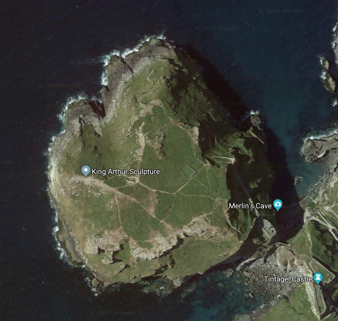
The area (now) known as Tintagel Island is a small, uninhabited, roughly circular peninsula on the north coast of Cornwall that is attached to the adjacent coastal cliffs by a narrow, low isthmus (Figure 1). The peninsula and adjacent cliff area are a (single) national heritage site on account of the presence of ruins of a 11th Century castle and remains of earlier settlements in both areas. Archaeological research suggests that the earliest ruins are those of a citadel that was first developed during the Roman occupation of the British Isles (between 43BC-410AD) and which flourished in the post-Roman period, (c410-700 AD) (Barrowman, Batey and Morris, 2007). The coastal castle site — referred to today as Arthur’s Castle — has been identified as a more recent construction, dating back to around 1230, commissioned by Earl Richard of Cornwall, probably influenced by Geoffrey of Monmouth’s popular De gestis Britonum (better known as History of the Kings of Britain) (1136), which identified Tintagel Island as King Arthur’s birthplace and the location of his famous court. Indeed, Orange and Laviolette have characterised the early 13th century site as effectively a “medieval folly or theme park” (2010:89). Sometime after its construction, and possibly in the 14th or 15th centuries, the castle site was abandoned, and its buildings decayed as a result of their exposure to the elements.
One aspect that remains unclear is the state of the isthmus in the Roman, immediately post-Roman and 13th Century periods. One of the main sources of perception on this topic is that of Monmouth’s aforementioned De gestis Britonum. Chapter 19 of Monmouth’s work describes Tintagel as “situated upon the sea, and on every side surrounded by it; and there is but one entrance into it, and that through a straight rock, which three men shall be able to defend against the whole power of the kingdom.” (2019: 142). This account stresses the narrowness and “almost-islandness” of the isthmus (through its description of it being surrounded by sea on “every side”) while also identifying the access point to it as “through a straight rock,” suggesting a cave, crevice or hewn passage (rather than a narrow neck of land between the two). As Ditmas (1973) has elaborated, aside from the considerable historical distance at which Monmouth’s account was written, there is no evidence that the author had any first-hand knowledge of Cornwall and/or access to reliable sources to inform his account1 and this description is, therefore, a slender basis upon which to build a perception of the peninsula’s linkage to the coast in this period. The presence of what appears to have been similar period constructions on both the cliffs and peninsula in the Roman and immediate post-Roman period has led some researchers to assume that the isthmus was once at a similar height to the cliffs on the grounds that it is implausible that settlements would have been erected in both locations without a far more convenient access point between them than the steep depression that current sits between the two. But as persuasive as this point might be, plausibility is significantly different from proof and the nature of the isthmus in the periods of previously discussed construction and use is still open to dispute.
The history of the Tintagel site between the 12th and 19th Centuries is unclear since the area largely disappeared from recorded history until the Victorian era when Tennyson re-popularised Arthurian legendry in his poem ‘Morte d’Arthur,’ written in 1842 (and subsequently included in his expanded work ‘Idylls of the King,’ published in various versions over the following decades). Tennyson’s work imbued the area with mythic/historical associations that were exploited by the development of local Arthurian-themed tourism, particularly following the introduction of rail services to Cornwall that reached the nearby town of Camelford, seven kilometres to the south-east of Tintagel village, in 1893. Some indication of early destination branding for the area can be gleaned from the names of the Duke class 4-40 steam locomotives serving the route (such as Excalibur, Guinevere, King Arthur, Merlin and Sir Lancelot). Within a few years, visitors conveyed from Camelford to Tintagel were accommodated at Arthurian-themed establishments such as King Arthur’s Castle Hotel, constructed on the clifftop overlooking Tintagel Island in 1899.2
Period accounts suggest that in the late 1800s the isthmus was closely similar to its present-day condition, requiring steep descent from the clifftop to a low rock isthmus and subsequent steep ascent to the top of the peninsula. At this time two significant toponymic changes occurred. The first concerned an extension of the place name Tintagel. Prior to the mid-1800s the name Tintagel was applied to the peninsular and adjacent cliff areas discussed above. While the origins of the name remain unclear, one commonly cited interpretation is that the name derives from the Cornish word din/tin (meaning fort) and tagel (meaning a constriction or choke and suggesting an isthmus in this context). Despite this interpretation, from the mid-1800s on the area referred to by the name Tintagel expanded to encompass the village formerly known as Trevena.3 The second toponymic shift was that the peninsular became referred to as Tintagel Island (perhaps to distinguish it from the newly re-named village). (NB there is no evidence that that the term 'Tintagel Island' or any Cornish language equivalent to it was used prior to the mid 1800s, although the possibility of some usage of this type cannot be entirely ruled out4). From the Victorian period onwards, visitors had to scramble down and across the low isthmus in order to access the island before wooden steps were installed in 1975. Despite locals’ and tourists’ experiential knowledge of there being a physical passageway between the coast and the peninsula, the designation of the latter as an island has persisted in the 20th and 21st centuries in local place-naming, in tourism promotion and in official and academic literature.5 Reflecting this, Malcolm Reading Consultants (MRC), employed by English Heritage to manage the bridge project discussed in detail below, have characterised the coastal site in the following terms:
The Island’s Dark-Age connections with the Byzantine world prompt myriad, fascinating questions… Its cultural legacy dates back more than a thousand years to earlier Cornish legends and tantalizingly suggests that folk memories of an earlier, illustrious epoch may have survived — if the historical record did not. Even to call it Island is to succumb to its romance. More accurately, it is a headland attached to a peninsula. But somehow, Tintagel creates a charmed atmosphere. Though it’s not physically distant, it creates the impression of being removed. Though it adapts to the age, it allows us to suspend time. The defining feature of Tintagel for much of its history was its natural land-bridge, a slender isthmus, linking the headland to the mainland… This physical connection — a tenuous rocky link much eroded over the centuries — is the source of its traditions and astonishing cultural resonance. (2015)
The phrasing of the MRC’s statement is significant in problematising the location’s status as an island (with regard to its connecting isthmus) while at the same time emphasising its island-ish qualities. Discussing the “allusive richness” of the term presqu'île, Fleury and Raoulx (2104: 19) have stated that scale is a significant factor in that, “the smaller the island is the more ‘island’ it appears (îleité in French — ‘islandness’)” and, similarly, “the presqu’île is more a presqu’île when it is smaller (presqu'îléité).” This emphasis is pertinent with regard to Tintagel Island in that its size, the narrowness of its isthmus and its historical associations all combine to make it so ‘almost’ an island that it can easily bear designation as an island. The perception of the location and its mode of access were however subject to significant alteration in the period 2016-2019 when the English Heritage organisation issued a call for design submissions to construct a footbridge between Tintagel’s coastal clifftop site and the top of Tintagel Island and subsequently by the bridge’s erection and opening in Summer 2019. The following section examines the factors at work in this process, its contestation and the modification of Tintagel Island’s identity that resulted.
English Heritage
Organised national initiatives to preserve Britain’s ancient historical sites and buildings of significance from various eras date back to 1882, with the passing of the (first) Ancient Monuments Protection Act, which was specifically addressed to 68 ancient monument sites that were perceived to be threatened by developers (including Stonehenge, Avebury and Silbury Hill). A complex history followed. A second version of the Act in 1900 allowed the government’s Office of Works6 (OoW) to add further sites and a third revision in 1910 allowed the OoW to receive and subsequently manage sites gifted to it and also established penalties for damage to listed sites. The number of protected locations grew to over 3000 shortly before the passing of the 1931 Ancient Monuments Act, which empowered the OoW to impose preservation schemes on areas around listed sites, and to ensure public access and provide facilities for visitors. During World War Two the OoW was subsumed by the Department of Works (DoW), which coordinated the construction of official buildings. In the late 1940s the DoW expanded the OoW’s earlier frames of reference by acquiring more modern buildings and assembling a “national collection” of ancient and more contemporary sites. The next significant revision arose in 1983 with the National Heritage Act, which shifted the protection of England’s registered heritage collection to a new body, initially referred to as the Historic Buildings and Monuments Commission (HBMC) but renamed English Heritage later in the year. In 2015 English Heritage was split into two organisations. One, Historic England, was dedicated to preserving traditional landscapes and environments (and running the Historic England Archive) while the other, which retained the name English Heritage (and is henceforth referred to as EH), took over management of ancient sites and historic buildings.
Established as a registered charity (with an 80 million pound start-up grant), EH’s founding model specified that the organisation would:
embark on an ambitious eight year programme to enhance and improve the Collection [that would] enable the charity to continue to grow its income and be a more resilient organisation, in control of its finances, able to plan more effectively for the long term… free to develop its business in the best way it sees fit… conserving the best of our historic environment and promoting its position at the heart of sustainable growth. (Vaizey, 2013: 4)
As the above statement suggests, the rhetoric informing the revised EH went far beyond preservation and maintenance and stressed (however ambiguously) “enhancement” of its assets and “sustained growth” in terms of income and overall scale of operation.
Even prior to EH’s redesign, its powers and activities attracted criticism from particular sectional and/or regional interest groups. One area of dissent relevant to this article concerns EH’s activities and profile in Cornwall. Following a revival of interest in traditional Cornish (Celtic-Brythonic) language and culture and related senses of the subsumption of Cornish identity and autonomy within an anglophone nation-state — in the late 1800s and early-mid 1900s, several activist organisations arose to prosecute the cause. Along with the Mebyon Kernow party, the revived Seneth Stenegow Kernow (SSK) has also been a significant actor in local politics. The SSK was conceived in 1974 as a modern successor to the ancient Stannary Parliament that was established in 1508 by English monarchy to give autonomy to those involved in the mining and related trading of tin and which last met in 1753. The modern SSK interpreted their predecessor’s powers as relevant to a range of contemporary issues and have claimed all mineral rights in Cornwall, exemption from UK taxes and UK laws. While many of their claims have been rhetorical, the SSK attracted national press coverage for what was represented as a ‘guerrilla’ campaign against EH in 2000. The SSK’s grievance against EH concerned their perception of the manner in which Cornwall’s distinct heritage was being subsumed and misrepresented by EH and its branding of Cornish sites as English heritage assets. Following EH’s refusal to respond to a written petition on the issue in 1999, a group of eight SSK members began to remove EH signs from sites such as Chysauster, Tintagel and Pendennis Castle in 2001, leading to their prosecution for criminal damage at trial in Truro in 2002 (where they were acquitted after they agreed to return the signs and pay financial compensation for damage caused). Despite the cessation of the SSK’s campaign against EH, the issue arose again in a different form in 2011 when George Eustice, the Conservative Party MP for the UK parliamentary constituency of Camborne and Redruth, attracted national media attention by calling for Cornish heritage sites to be devolved to a separate body named Cornish Heritage following a disagreement with EH over the development of Hayle’s South Quay area. Attention returned to Tintagel in 2015 when there was local opposition to the carving of an image of Merlin above the entrance of a cave near the waterline popularly known as Merlin’s Cave in 2016. As Williams (2016) has detailed, the figure’s face was subsequently being damaged by chiselling in a consciously iconoclastic act. EH’s announcement of plans to install an eight-foot high statue inspired by Arthur on the top of Tavistock Island met with similar criticism, with the Cornish Association of Local Historians publicly criticising what it perceived to be an attempt to turn the island into a “fairytale theme park” (Morris, 2016). In what might be perceived to be a tacit acknowledgement of the previous dispute over the Merlin’s Cave rock carving, the (very-Arthur like) eight-foot high bronze statue, by Rubin Eynon, was eventually named ‘Gallos’ (supposedly after the Cornish language name for ‘power’ but more accurately translating as ‘capability’ [Cornwall Net, 2016]) rather than ‘Arthur’. Despite its title, the work remains controversial.
The latest in the series of disputes over EH’s management and development of the Tintagel site overlapped with the statue controversy. It commenced in 2015 when EH announced plans for a bridge between the Tintagel site’s coastal clifftop and the upper area of Tintagel Island. EH employed the architectural consultants Malcolm Reading (MRC) to formulate and publicise a call for bridge designs. Tintagel’s ‘almost islandness’ was central to MRC’s perception of place and their (aforementioned) characterisation that “a tenuous rocky link” between Tintagel Island and the coast “is the source of its traditions and astonishing cultural resonance,” is notable but immediately attracts attention within the context of a document and scheme intended to supersede the link so central to the (almost) island’s long-established identity. The MRC document emphasises the rationale for the bridge in terms of customer convenience, reflecting English Heritage’s apparent perception that existing place identity is less important than maximising ease-of-access for tourists. Opening with a confident statement of its design competition’s rationale, MRC’s website claimed that:
Certainly, a new bridge is needed. The existing approach is perceived by some non-visitors as demanding and although many visitors enjoy the experience some can find it a challenge. The current single track pathway is narrow, and on peak days can get congested and cause queues on and off the Island. This single point of entry is also leading to wear and tear on some parts of the path, and encourages a circulation route that results in many visitors bypassing the castle’s outer ward and gateway, thereby remaining unaware of this important section of the monument.
While the general characterisation of the existing walkway is accurate (and could also have mentioned the the slipperiness of sections of the wooden steps on wet days), its arguments — “certainly a new bridge is needed” — are hardly conclusive. Whatever impediments there are to accessing Tintagel Island, crossing over is hardly comparable, for instance, to the rigours of hiking to Peru’s Machu Picchu site, which attracted over 1.5 million visitors in 2018 (sunflower, 2019).
The competition’s (2015) brief conveyed a very different concept of the envisaged visitor experience to both the site, as it is currently experienced, and of the bridge (as a thing-in-itself), contrasting MRC’s vision of the bridge’s modernity to the natural and built heritage elements of the locale:
Twenty-eight metres higher than the current crossing, 72 metres in span and roughly 2.4 metres wide… the bridge will transform the visitor experience, opening up exhilarating views of the Island, coastline and Atlantic seascape. It will also create a direct route to the Island, relinking the castle with its original entrance … More than just a practical passage, the bridge should exemplify design at its most assured. English Heritage envisages an elegant, even structurally daring, concept, both beautiful in its own right and sensitively balanced with the landscape and exceptional surroundings…
The emphasis on the bridge being “sensitively balanced” reflects EH’s raison d’etre and the particular protection designations of the Tintagel site. The coastal castle ruins and the whole island are a scheduled site protected by 1979 Ancient Monuments and Archaeological Areas Act and this scheduled area nested within a group of intersecting designations of the broader coastal stretch, including as Cornish areas of Outstanding Natural Beauty and Great Historic Value.
Unlike more traditional approaches to conservational stewardship, EH’s self-declared purpose is to “capture the nation’s imagination with a handful of high-profile, memorable new visitor experiences” (English Heritage, n.d.) and the Tintagel bridge project exemplifies this approach. As the call for proposals detailed, the central element of the redeveloped site was a proposed footbridge that EH envisaged as “running along the line of original land-bridge into the castle entrance,” with the aim of allowing “today’s visitors to experience the drama of the original (now eroded) higher level crossing” (English Heritage, n.d.). More than historical recreation, the project was intended to “create thrilling new viewpoints of the Island, coastline and the Atlantic seascape,” while noting that, “at the same time, careful consideration will need to be given to the impact of the bridge on the integrity of the monument, the long views of the bridge along the coast and the impact of the profile of the bridge itself on views on approaching the Island” (English Heritage, n.d.).
A number of Cornish activists objected to the project from its earliest stages and made representations to Cornwall County Council (CCC) when the winning design was submitted for approval. The project proved divisive with local bodies such as CCC’s planning officers and Highways Department, Tintagel Parish Council, Visit Cornwall, Cornish Buildings Group and (somewhat surprisingly) Cornwall Archaeological Society lining up behind EH and Historic England to support the proposal; while other pro-autonomy groups, such as Gorsedh Kernow and Kernow Matters To Us lined up with the Cornwall Geoconservation Group and Cornwall’s Area of Outstanding Natural Beauty Unit to oppose it. Indeed, so concerned were the latter over CCC’s approval of the bridge that they referred the Council’s decision to the Secretary of State for Housing, Communities and Local Government in Autumn 2017 seeking a review and revised decision. (Becquart, 2017). Their request was declined and work on the bridge commenced in October 2018, with the site closed for the period of construction.
The winning entry in the MRC administered competition was by Belgian bridge designers Ney & Partners and UK architects William Matthews Associates and comprised two cantilevered sections with a small (40 cm wide) gap at the mid-point, creating a 72 metre-long (broken) span. In their presentation to the architectural jury assembled by MRC, the team’s presenters explained the rationale for their design in the following terms:
The narrow gap between the cantilevers represents the transition between the mainland and the island, here and there, the present and the past, the known and the unknown, reality and legend; all the things that make Tintagel so special and fascinating… using local slate for the bridge’s decking and contrasting weathered and non-weathered steel to create finishes which allow sunlight to play on the structure… also give it an ephemeral quality, allowing the bridge to harmonize with the coastal landscape. (Testado, 2016)
While jury chair Graham Morrison reported that “the jury was persuaded as much by the technical assurance of Ney’s proposal, and its buildability, as its aesthetics and sensitivity to the exceptional setting” Testado, 2016), the latter aspects are clearly significant for the perceptions and issues explored in this article. One of the images used by Ney & Partners and UK architects William Matthews Associates as part of their project pitch (Figure 2) merits discussion. While accurate in documenting the intended (and realised) positioning of the new bridge over the low isthmus area, it also neatly crystallises a number of the concepts central to the bridge designers’ vision and the support this received from EH and CCC. There are two principal vectors in the image that emanate from a shared departure point at the mid-bottom left of the image (a point on the clifftop immediately opposite Tintagel Island). The top vector arrows in to a point on the upper portion of the island along the receding perspective line of the bridge. It is illuminated along its entire length by sunlight and represents a direct route to the island that suggests smooth, unfettered access along a gleaming metallic pathway. By contrast, the wooden steps that depart from the same point descend vertiginously, twisting and rambling into shadowy darkness to a point with no obvious path to the island’s peak. If the first vector connotes airiness and modernity, the second one suggests toil and history (the Dark Ages and beyond). The former is seen to soar over the latter, representing progress, suggesting the old route as redundant and implicitly validating the experience of crossing the bridge over those of negotiating the steps, removing the sense (and tired muscle memory) of slopes negotiated in favour of an almost effortless stroll across a suspended pleasure path.

Conclusion
Upon its completion, Kate Mavor, EH’s CEO summarised her organisation’s official position with the succinct — but nonetheless highly problematic — characterisation that “Tintagel Castle has been made whole again” (Mitchell, 2019). The bridge was formally opened to the public, after a protracted delay, on July 23rd 2020 by the Duke and Duchess of Cornwall with a predictable combination of promotional hoopla and sympathetic media coverage that ignored the critical counter discourse of Cornish activists and held the EH line. Subsequent patterns of site usage, perception, representation and reflection will determine the manner in which the bridge’s occupation of space and sightlines and its impact on the location’s previous almost-islandness will ‘over-write’ earlier perceptions and inscriptions of the island. The 40cm gap between the two cantilevered spans may be a minor symbolic detail but does represent a tacit acknowledgment that the bridge modifies the site and the overall sense of space in the locale. In terms of the characterisations of bridging discussed in the introduction to this article, the new bridge clearly represents modernity, improves access to Tintagel Island (thereby embodies notions of progress in a practical-mechanical sense) and constitutes an attraction-in-itself. Viewed in this light, opposition to it can be seen to represent nostalgia and with opponents clinging to pre-modernity as an ideal. But viewed in another light, the bridging can be seen to represent a significant modification of a specific entity — a peninsular ‘almost island’ whose status has such has been key to experience of it. In a manner akin to John Gillis’s quotation that prefaced this article, the “spatial practices” formerly involved in access to it can be understood to have created a sense of temporal ‘remoteness’ that activated the ‘pastness’ of the place. It is the loss of these aspects (within a broader concern about the over-commercialisation of the site) that raised the ire of Cornish activists who regarded the modification as part of an ongoing indifference to/erasure of Cornish identity by both EH and institutions of the UK nation-state in general. Of course (at present, at least) Tintagel Island can still be accessed by the steps but any such experience is now one that has to be consciously undertaken in preference to an easier path. In addition, the steps now run underneath a soaring reminder of the site’s modern connection to the coastal mainland, with the path and its wooden steps increasingly a relic of earlier modes of access. Within spatial-conceptual terms, Tintagel Island is now doubly connected to the coast by fixed links — its low, rocky isthmus and high, metallic bridge — rendering it even less viably an ‘island’ in anything but a metaphorical sense that primarily reflects historic perception and usage. In this manner, EH has transformed (rather than “enhanced”) Tintagel Island, erasing the “inconvenience” of its dipping isthmus in favour of a seamless integration to the coastal cliffs by means of a linear, fixed link that exemplifies modernity and metropolitan nationalist agendas and decision-making processes.
Endnotes
References
- Alfred Lord Tennyson. 1838. ‘Morte d’Arthur.’ URL: https://www.poetryfoundation.org/poems/45370/morte-darthur
- Baldacchino, G. (ed). 2007. Bridging Islands: the impact of fixed links. Charlottetown: Acorn Press.
- Baldacchino, G. 2007. Introduction: Bridges and Islands: A Strained Relationship. In Baldacchino, G. (ed), Bridging Islands: the impact of fixed links. Charlottetown: Acorn Press: 1-14.
- Barrowman, R., Batey, C. and Morris, C. 2007. Excavations at Tintagel Castle, Cornwall, 1990-1999. London: Report of the Research Committee of the Society of Antiquaries.
- Becquart, C. 2017. This is what the Government has said about overruling Cornwall Council’s decision on Tintagel Bridge. Cornwall Live 18th November. URL: https://www.cornwalllive.com/news/cornwall-news/tintagel-bridge-planning-decision-cornwall-796894
- Cosgrove, D. 2007. Island Passages. In Baldacchino, G (ed) Bridging Islands: the impact of fixed links. Charlottetown: Acorn Press: 15-28.
- Ditmas, E.M.R. 1973. A Reappraisal of Geoffrey of Monmouth's Allusions to Cornwall. Speculum 48 (3): 510-524.
- Fleury, C. and Raoulx, B. 2016. Toponymy, Taxonomy and Place: Explicating the French concepts of presqu’île and péninsule. Shima: The International Journal of Research into island Cultures 10(1): 8-20.
- Geoffrey of Monmouth. 2019. De gestis Britonum (modern English translation by Aaron Thompson and J.A. Giles as History of the Kings of Britain). URL: https://en.wikisource.org/wiki/History_of_the_Kings_of_Britain
- Hayward, P. and Fleury, C. 2020. Bounded by Heritage and The Tamar: Cornwall as ‘almost an island’. Island Studies Journal 15(1): 223-236.
- Malcolm Reading Consultants (for English Heritage). 2015. Tintagel Castle: Bridge Design Competition. URL: https://competitions.malcolmreading.co.uk/tintagel/
- Mitchell, B. 2019. English Heritage has unveiled the Tintagel Castle Bridge in Cornwall: The new footbridge doesn’t quite meet in the middle, but links the remains of Tintagel Castle. Blooloop 12th August. URL: https://blooloop.com/news/tintagel-castle-bridge/
- Morris, S. 2016. English Heritage turning Tintagel into fairytale theme park. The Guardian 22nd March. URL: https://www.theguardian.com/uk-news/2016/mar/22/english-heritage-turning-tintagel-into-fairytale-theme-park
- Orange, H. and Laviolette, P (2010). A Disgruntled Tourist in King Arthur's Court: Archaeology and Identity at Tintagel, Cornwall. Public Archaeology 9(2): 85-107.
- Steinberg, P. 2007. Bridging the Florida Keys. In Baldacchino, G (ed), Bridging Islands: the impact of fixed links. Charlottetown: Acorn Press: 128-138.
- Sunflower. 2019. How many tourists visited Machu Picchu in 2018. Peru Telegraph 19th March. URL: https://www.perutelegraph.com/news/peru-travel/how-many-tourists-visited-machu-picchu-in-2018?fbclid=IwAR33tjxDJCfvHTcGdUETtHNOyU_8o_bRzRuu59XvsOAGiif4gG0zMeR-fsM
- Suwa, J. 2007. The Space of Shima. Shima: The International Journal of Research into Island Cultures 1(1): 6-14.
- Testado, J. 2016. Ney & Partners + William Matthews Associates to redesign Tintagel Bridge. Architect News 30th March. URL: https://archinect.com/news/bustler/4794/ney-partners-william-matthews-associates-to-redesign-tintagel-bridge
- Vaizey, E. 2013. Foreword. Department for Culture, Media and Sport, English Heritage New Model — Consultation. URL: https://assets.publishing.service.gov.uk/government/uploads/system/uploads/attachment_data/file/263943/1291-B_English_Heritage_Accessible__1_.pdf
- Williams, L. 2016. Iconoclasm: Cultural Identity Through Image: An evaluation of the vandalism of the Merlin Sculpture, Tintagel Castle. Nottingham Trent University.