An overview of small island management and biodiversity protection in Albania
Abstract
While tourism has become the key to the economic prosperity and development of Albania, most islands located in the marine and non-marine environment are now facing immediate and significant problems. Regardless of their size, Albanian islands are facing various conservation and management challenges today due to local environmental problems that are associated with tourism development. There is significant potential for a more sustainable tourism across the country. The aim of this paper is to give a framework and overview on the management of protected areas in small islands in Albania with particular focus on those located in coastal areas. Frameworks for conservation development and coastal zone management are suggested taking into account the nature of the surrounding coastal or littoral environment. The conservation approach primarily looks at the plastic-free area and waste management, issues of great concern that have been featuring in the last three decades of the country’s transition from collective to market economy. In order that biodiversity richness to continue to provide opportunities for responsible tourism, it is argued that such frameworks should be adaptable and implemented for sustainable development.
Keywords
marine environment, island, coastal zone management, marine and coastal tourism, sustainable tourism development
Introduction: State and challenges dominated by lack of waste management
The Mediterranean Basin constitutes the second largest hotspot on a global scale and its European part is one of the world’s major centers of biodiversity (Natopanou and Panitsa, 2020; Blonde et al., 2010) due to an ensemble of highly heterogeneous habitats with diverse topographies, soil types, and microclimates related to altitude, slope exposure, and precipitation (Médail and Quézel, 1997). For a long time globally, islands have been branded long before the concept found its way into management practices (Baldacchino, 2012; Calado et al., 2014), while the small ones are now, unwittingly, the objects of what may be the most lavish, global and consistent branding exercise in human history (Baum et al., 2000; Baldigara et al., 2012; Starc and Stubbs, 2014; Baldacchino, 2012, Gamberožić, 2021). Further on the island ecosystems have always played a leading role in conservation biology (Nogué et al., 2017). They are often described as natural laboratories, providing model systems for the testing of evolutionary, ecological and biogeographic theories (Vitousek, 2002). Even small, nowadays the Albanian islands are facing various conservation and management challenges due to local environmental problems that are associated with tourism development and lack of planning. As a part of Mediterranean Sea, they are broadly considered one of the most threatened environments in the world, since it is a subject to ubiquitous plastic pollution, while it is widely known that plastic contributes heavily to the degradation of the environment and is a massive contributor to climate change (Chisholm Hatfield, 2019). As a result of high population densities, lack of consistent waste-management schemes, and large influxes of tourists and strategic merchant navigation, this environment is under significant pressure. The total plastic accumulated in the Mediterranean Sea is estimated in the order of magnitude of 1,178,000 tones, with a possible range from 53,500 to 3,546,700 tones (Boucher and Bilard, 2020). This has adverse impacts on the health of ocean ecosystems, the integrity of food supplies and people’s livelihoods. Plastic pollution is a design, production, consumption, and disposal challenge that must be tackled across plastic’s entire lifecycle. Most efforts to minimize and mitigate the impacts of plastic pollution are focused on the mainland, particularly rivers and coastal areas. To date, not much attention has been paid to islands.
Increasingly the policymakers are appealing for more encompassing limitations on the production and consumption of single-use plastics and for improved post-use management (UNEP, 2020). The United Nations Environment Assembly, at its first, second, third and fourth sessions, in 2014, 2016, 2017 and 2019 respectively, adopted resolutions 1/6, 2/11, 3/7, 4/6 and 4/9 to address the environmental impacts of marine plastic litter and pollution from single-use plastic products. According to UNEP (2020), stressing the importance of the long-term elimination of the discharge of litter and microplastics into the oceans, the resolutions call on States Members to develop national actions to address the environmental impacts of single-use plastics. Resolution 4/9 also encourages States Members to develop and implement national or regional actions, as appropriate, to address the environmental impact of single-use plastic products, to take comprehensive action with regard to single-use plastic products in addressing related waste through, where appropriate, legislation and to take other actions to promote alternatives to single-use plastics, improve waste management and develop sustainable consumption patterns.
Further on the policymakers are also urging all actors to step up actions to achieve Sustainable Development Goal 14, which is, by 2025, to prevent and significantly reduce marine pollution of all kinds, from land-based activities, including marine debris and nutrient pollution (United Nations, 2015). This guide, therefore, aims to help States that are developing national legislation on plastic, including single-use plastics, in response to these resolutions.
The state and quality of the environment in a particular ecosystem, both natural and man-made, is essential to tourism, particularly for those countries such as Albania that strive after (or to achieve) rapid economic development and prosperity. Meanwhile, the relationship of tourism with the environment is complex and in many instances contradictory. It involves many activities that can have adverse environmental effects. Many of these impacts are linked with the construction of general infrastructure such as roads and paths, and of tourism facilities, including hotels, restaurants, shops and marinas. The negative impacts of tourism development can gradually deteriorate the environmental resources on which it depends.
On the other hand, tourism has the potential to create beneficial effects on the environment by contributing to environmental protection and conservation. It is a way to raise awareness of environmental values and it can serve as a tool to finance the protection of natural areas and increase their economic importance.
Islands Description, Location and Boundaries
The Albanides represent the assemblage of the geological structures in the territory of Albania, and together with Dinarides at the North and Hellenides at their South form the southern branch of the Mediterranean Alpine Belt, (Aubouen 1973,Frasheri et al. 2009, I.G.S. 1985). Two major paleogeographic domains form the Albanides: the Internal Albanides in the eastern part and the External Albanides in the western part of Albanides.
In different approaches, the Albanian islands are characterized as a natural rarity for research concerning species diversity while their habitats have a complex geological history that varies among their geographic locations (Tomàs-Vives, 2014.). The combination of different factors of variable intensity and duration time drives patterns of its impressive biodiversity richness.
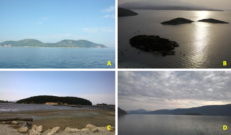
Sazani Island: The Island of Sazan is the largest island in Albania that is located between the Strait of Otranto in the north of Karaburuni Peninsula, forming the border between the Adriatic and Ionian Sea (Figure 1A; Figure 2). The island has its own length of 4.8 km and width of 2.7 km, with a total surface of 5700 ha. Its specific features of climate, hydrology and geological conditions are the base for characterization of the island itself as unique for its vegetation and biodiversity. Sazani Island is composed of limestone rocks of the Cretaceous period and in the eastern part partially of terrigenic and cleistogenic deposits (Kashta et al., 2011). The western coast is fragmented and steep, with high cliffs up to 40 meters deep cut by a number of gorges, caves, and small bays, such as the Bay of Paradise (Gjiri i Parajses) and the Devil Gorge (Gryka e Djallit). In the east, the coast has gentle slopes with St. Nicholas Bay (Ggjiri i Shënkollit), where the harbor and military facilities are, as an important geomorphological feature, and more to the south-west slanted folds of limestone that plunge into the sea. The island has a rugged topography, with two main hills, at an altitude of 334 (northern hill) and 307 meters (southern hill) (Tomàs-Vives, 2014). Further, the same author emphasizes that the island of Sazani is characterized by very diverse vegetation, forming a mosaic of many different plant communities in a relatively small area (570 hectares).
Kune Island: The Island of Kune is situated in the area of Kune-Vain Lagoon at the Albanian Adriatic coast. It lies in the Delta of old River Drini and has a surface of 1.4 km2. The area is distinguished by diverse habitats and species, including Mediterranean shrubs, ash and willow forests. Following the recent bird winter observation (Bino, T., 2021), the island hosts more than 70 different bird species. Further on there are recorded 22 species of reptiles, 6 species of amphibians and numerous representatives of mammals.
Malësori Island: Among the other features Buna River is distinguished for the lowland flow and isles presence. With its area of 40 hectares the Island of Malësori is situated within the River Buna in vicinity of Shkodra a city in northern Albania. Several villages are situated around the island; the nearest is Darragjat situated at a distance of less than 5 km from Lake Scadar/Shkodra, one of the largest lakes in Southern Europe.
Zverneci Island: The Islands of Zvërnec consist of two islands with a total surface of 10 hectares, the larger Zvërnec Island 8.7 hectares and the small Zvërnec Island with 1.3 hectares. They are located in the Narta Lagoon, southern Albania. The wooded island is characterized by pine trees and is connected to the mainland by a 207 meters long bridge. It has a length of 430 m and a width of 300 m. Zvërnec is also a main tourist attraction in southern Albania, where is situated well-preserved 13th century Byzantine, Zvërnec Monastery. Zverneci islet in the south of the Narta lagoon is covered with an evergreen forest of Cupressus sempervirens. The woody layer is dominated by Cupressus sempervirens and on a low scale by the species of Qurcus ilex, Quercus pubescent and Pinus spp. The vegetation cover is very dense. The shrub layer is dominated by the species of Myrtus communis, Pistacia lentiscus, Laurus nobilis, Rubus spp., Phillyrea angustifolia, Olea olaster, etc. The herb layer is rarer and the most frequent species are: Chrysopogon gryllus, Asparagus acutifolius, Dactylis glomerata, Desmazieria rigida etc. Under this zone, dominated by Cupressus sempervirens the cliffs (soft rock) support a plant community dominated by halophylic species such as: Suaeda maritima, Limonium oleifolium, Limonium vulgare, Arthrocnemum glaucum, Halimione portulacoides, Elymus pycnanthus, characteristic species of the association Suaedetum maritimae.

Shurdhah Island: The cascade reservoirs installed in 70' of last century along the River Drini created grounds for new isles as well. Shurdhah is located in the Vau i Dejës Reservoir drained by the River Drini in northern Albania, having a surface of 7.5 hectares. Ruins of an ancient Roman castle can be found within the island. Today, only the ruins of a medieval church are present.
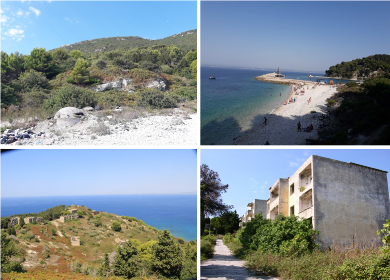
Ksamili Island: The Ksamili Islets are four small islands located in southern Albania, along the Albanian Riviera having a surface area of 9 hectares (Figure 3). The islands are remote and can only be accessed by boat. The village of Ksamil, after whom the islands are named, is located to the east of the islands. During the last three decades the elands were facing serious interventions affecting their natural integrity.
Maligrad Island: The Island of Maligrad is situated within the Lake Prespa, forming a part of the Prespa National Park in eastern Albania. It has a surface area of 5 hectares. The island hosts many caves suitable for wildlife and a circular cliff. Assessed threats to freshwater habitats of standing water – habitats type 3150 Natural eutrophic lakes with Magnopotamion or Hydrocharition – type, shores, also the protected plant species: Aldrovanda vesiculosa L. and Lindernia procumbens L., fauna species Otter (Lutralutra), Prespa Spined Loach (Cobitis meridionalis), Prespa Minnow (Pelasgus prespensis), Prespa Roach (Rutilus prespensis), and Prespa Trout (Salmo peristericus), Dice Snake (Natrix tesseleata), Macedonian Crested Newt (Triturus macedonicus), and Birds Directive species: Pygmy Cormorant (Microcarbo pygmaeus), Dalmatian Pelican (Pelecanus crispus), Little Egret (Egretta garzetta), Great Egret (Ardea alba), Squacco Heron (Ardeola ralloides), Black-winged Stilt (Himantopus himantopus), Common Kingfisher (Alcedo atthis), and the wintering water bird populations.
Tongo Island: The small island is located within the Albanian Ionian coast in southern Albania. It is a rocky island, and its waters are rich in aquatic life. The island is situated about 300 m far from the Greek coast. It has a surface area of 2.5 hectares.
Stillo Island: Stillo is a small, rocky and sparsely island located near the Cape of Stillo, Vlorë, and southern Albania. During the communist regime, the island was used as a military zone in 1992 and access was prohibited. Although not the most southern point of Albania, it consists of the southernmost tip of the entire coastline of Albania. Its total area is 0.7 hectares, with an approximate length of 80 m and a width of 100 m.
Paqe Island: The Islet of Paqe is located within the Koman Lake in northern Albania, near the Albanian Alps and Fierzë. It is found in one of the lake's river canyons. Paqe Island is only 160 m long, having a surface of 0.3 hectares. The islet is small with many trees on top of it. There are many islands within the Fierza Lake as well as in Koman Lake, that are much larger and stonier textured than Paqe Islands’ sandy ground.
Current Legal Status and challenges for integrating development into conservation practices
The Government of Albania has approved a System of Environmentally Protected Areas. Currently, the area of the Network of Protected Areas of Albania reaches 504,826.3ha, over 17.56% of the total area of the country. Of the total area, the Coastal and Marine Protected Areas constitute 119,224.7ha, or 23.6% of the total surface of the country's protected area system, of which 13,261.2ha is only marine area. Also, 98,180.6ha, are with the status of Ramsar areas, which cover 3.42% of the total area of the country (MoTE, 2019).
| Name of the Island | Current Status of Protection |
|---|---|
| Sazani |
|
| Kune |
|
| Zvërnec |
|
| Malësori |
|
| Franc Jozeph |
|
| Maligrad |
|
| Ksamil |
|
The basis of this system consists mainly of: 2 Strict Nature Reserves (4,800ha); 14 National Park (230,707.20ha); 721 units with the status of Natural Monument (1,970.0ha); 24 Managed Nature Reserves / Nature Park (151,770.40ha); 6 Protected Landscape (97,333.60ha) and 4 Protected Area of Managed Resources (18,245.00ha).Based on the Strategic Policy Paper for Biodiversity Protection (MoTE, 2016), the Ministry of Tourism and Environment (MoTM) and the National Agency for Protected Areas (NAPA) are committed that by the end of 2020, the surface of the protected areas network reach over 20% of the territory of the country.
Until the beginning of 2015, the management of protected areas was the responsibility of the Ministry of Environment (MoE) and was included in the structure and tasks of the Forest Service Directorates (DFS) in the districts. With the creation of the National Agency of Protected Areas (NAPA) on February 4, 2015, the management of the protected areas system took a whole new approach. NAPA and structures at the local level have a great responsibility and challenge to face the current situation and the perspective, where to take the protected areas and their management. This is also due to the fact that protected areas, in Albania, are evidenced in various forms and sizes (land, water, sea, local and cross-border); in public, municipal and private ownership; in 6 categories of administration; Ramsar wetland area of international importance; Biosphere Reserve (RB) and as UNESCO World Heritage Sites (United Nations Educational, Scientific and Cultural Organization), i.e. a complexity and natural heritage that should be clearly reflected in the national environmental program.
Regarding the administration and management of the Marine Protected Area, the Decision of the Council of Ministers no. 289 establishes that measures for ensuring the protection, monitoring and development of submarine ecotourism in the National Park Karaburun-Sazan will be taken by the Ministry of Environment in cooperation with the Ministry of Tourism, the Ministry of Defense and scientific and coastal institutions. The Decision assigns the management of Karaburun-Sazan National Park to the administration of the existing Protected Area Llogara-Karaburun, which is the Forestry Service Directorate.
| Agreements and policies | Year of accession or ratification by Albania | Relevance to management of PA |
|---|---|---|
| Convention on Biological Diversity (CBD 1992) | 1994 | Aims to conserve biological diversity, sustainable use of its components and fair and equitable sharing of benefits arising from genetic resources. |
| CBD Aichi targets (to be met by 2020) Target 11 Target 12 |
2010 | Target 11. Include 17% of terrestrial and inland water, and 10% of coastal and marine areas in systems of protected areas Target 12. Prevent extinction of threatened species and improve their conservation status |
| Barcelona Convention for the Protection of the Marine Environment and the Coastal Region of the Mediterranean (1975, amended in 1995) | 1990/2001 | Aims to protect the Mediterranean marine and coastal environment while boosting regional and national plans to achieve sustainable development |
| Protocol Concerning Specially Protected Areas and Biological Diversity in the Mediterranean (1995) | 2001 | Aims to promote the conservation and sustainable management of marine and coastal areas with natural or cultural values and to promote the conservation of endangered or threatened species |
| Bern Convention on the conservation of European wildlife and natural habitats (1979) | 1999 | Aims to conserve wild flora and fauna and their natural habitats and to promote European cooperation |
| Bonn Convention On the Conservation of Migratory Species of Wild Animals (1979) | 2001 | Aims to conserve terrestrial, aquatic and avian migratory species throughout their range |
| Eurobats: Agreement on the Conservation of Populations of European Bats (1991) | 2001 | Aims to protect all European bat species through legislation, education, conservation measures and international cooperation |
| United Nations Convention to Combat Desertification (1994) | 2000 | Aims to reverse and prevent desertification/land degradation and to mitigate the effects of drought in affected areas in order to support poverty reduction and environmental sustainability |
Evaluation of the islands’ integrity and institutional framework
Small islands’ particular characteristics (isolation, limited physical space and natural resources, history of development and evolution, closed systems, endemism, and terrestrial/marine ecosystems linkages) add specific problems in terms of habitats and species conservation. Given the fact of size and particularities of small islands, the Millennium Ecosystem Assessment (2005) addresses the environmental problems that are in line with current problems facing Albanian islands:
- Limited and highly vulnerable water resources: freshwater sources are limited to surface reservoirs and groundwater aquifers, highly dependent on rainfall, varying with the geographic location and the climate of the island. Following Calado et al. (2014) this scarcity and increasing demand make these resources more vulnerable to sea-level changes, problems of over pumping of ground water (and consequent salination) and contamination through leaching of soil residues, pesticides and fertilizers;
- Vulnerable and endemic species: high number of endemic species, species with low competitive ability, limited distribution and small populations, with lower adaptive capacity and consequent tendency to extinction phenomena;
- Invasive and alien species: invasive species may compete directly or indirectly with native species and alter ecological processes, faster and in a more pronounced way than in mainland territories, thus causing serious ecological and economic damage, with high social costs. In addition to these issues, economic and social particularities create other pressures on the ecosystems. The distribution and spread of the alien species as Atlantic blue crab (Callinectes sapidus) are reported from marine, transitional and freshwater environments along the coasts of the Adriatic Sea including small coastal islands of Albania. The damage caused by non-native crab expansion is already documented and a problem that fishers face primarily. The rapid expansion of C. sapidus in the coastal and transitional water may cause severe impacts on local biodiversity and economic activities since the invading lagoons in the region support commercial fisheries and aquaculture activities. Mancinelli et al. (2017) showed that the blue crab can interact, by competition or predation, with a wide spectrum of native crab and fish species resulting in potentially high ecological impacts. The fishers repeatedly report damage to nets, catch fish on nets, consumption of bivalves, and many other unknown biota components. Further on a wide presence of a serpulidpolychaete (Ficopomatus enigmaticus) has been recorded in the large drainage channels in the wider project area due to drainage works. Ficopomatus enigmaticus, originally named Mercierella enigmatica, is a serpulidpolychaete worm that builds and inhabits white calcareous tubes that vary from 1.85 to 2 mm in mouth diameter and 20 to 40 mm in length. Colonies were firstly identified for other Albanian coastal areas (Shumka et al., 2013).
The climate variations can also be responsible for the invasion of unusual species in lagoon and jellyfish Aurelia aurita and Rhizostoma pulmo. In the year 2015 presence of Rhizostoma pulmo has been recorded in the vicinity of Zverneci Island. The increased abundance may affect fishing activities or even have an effect on the fish commercial value (Molinero et al., 2009).
Further to the above concerns during the last three decades, the use of plastic materials in Albania has shown a significant increase along with economic and demographic developments. This is easily identified by the large quantities of plastic materials consumed and from the increased demand for plastic material from the recycling industry. The vast majority of raw materials for recycling is imported. Following Liço et al. (2015) for the period of years 2009-2014 the quantity of imported plastic materials (raw materials, products and generated after consumption) is assessed to reach an amount of 57000 to 60300 tones/year.
The other economic and social particularities create other pressures on these complex ecosystems. On most of Albanian islands, fishing has always represented an important source of income generation being an important local economic activity. Similar patterns are observed in other areas of the Mediterranean where the increased demand has been associated with new fishing techniques that put into question the sustainability of this activity and the maintenance of stocks, already threatened by natural hazards and pollution (Calado et al., 2014).
As pointed above the protected areas play a key role in the conservation of threatened natural and cultural heritage. Meanwhile, the management of the protected areas entails a difficult balance between different objectives, where the major one is integration of development practices into conservation approaches. Following Calado et al. (2014), protecting the natural values while ensuring opportunities for socio-economic development can be even more complex in island systems, where space is extremely limited and natural resources cannot be separated from human activities. Integration of local communities’ interests remains a consistent challenge. Following the IUCN Guidelines for management planning of protected areas (Thomas & Middleton, 2003) the main benefits of involving stakeholders in management planning are linked to an increased sense of ownership, greater public involvement in decision-making and closer links between conservation and development.
The institutional framework is complex. On one side, some of the sites, such as Sazani, currently have military status and require the agreement of a shared vision and compromise, which can only be a reality under a strong commitment and a full coordination effort between the different institutions concerned: the Ministries of Defense and of Environment, the National Coastal Agency, the Regional and Local Authorities, and national and local stakeholders (Tomàs-Vives, 2014).
Current territorial reform was placing Islands in different municipalities, while some of them (see Table 1) are part of the national protected system and administrated by NAPA. This development should be seen as a positive one that might facilitate reaching a consensus among all the relevant institutions on the future status of the island and on considering its high natural, historical and cultural values as an added value to the whole local and Albanian society (Tomàs-Vives, 2014). Further, the role of the Regional and Local Authorities, NGOs, etc. is very important, as they can play the leading role in the promotion of more sustainable socio-economic activities in the region/municipality that can accelerate clean Islands and plastic free ones.
Conclusions
All Albanian islands along with the high touristic attractions have numerous added ecological values. Due to their high habitat and species diversity, interest in the flora and vegetation, and geographical locations, they are a crossroads between different destinations, and between the eastern and the western Mediterranean. Following current tourism development in coastal areas of Albania, it can be clearly stated that there is an urgent need for sustainable planning and integration of development practices into conservation approaches.
In this context, the key component for securing intended sustainable tourism, the key actors involved in the tourism development of isles are the local communities. To that fact, there is a need for setting clear development objectives, accommodating local interest and prosperity, while considering nature conservation approaches.
Further research is required that focuses on the types of tourism that would be more appropriate for the Albanian islands’ development, the importance of traditional knowledge and implications to local economic development scenarios.
References
- Auboin, I., 1973. Overthrust tectonic and their signification in the relation to geophysical models: on example of Dinarides, paleotectonic, past-tectonic, neo-tectonic. B.S.G.F. (7th), 1, XIX, Paris.
- Baldacchino, G., 2012. The lure of the island: A spatial analysis of power relations. Journal of Marine and Island Culture. 1: 55–62. 10.1016/j.imic.2012.11.003
- Baldigara, T., Pagliuca, M., Rosciano, M., 2012. A., 2012. Comparative Study of Italy’s and Croatia’s Inbound Tourism Statistics, in: Tourism and Hospitality Management 2012, Conference Proceedings, Opatija: Faculty of Tourism and Hospitality Management, pp. 215–227.
- Baum, T.G., Hagen-Grant, L., Jolliffe, L., Lambert, S., Sigurjonsson, B., 2000. Tourism and cold water islands on the North Atlantic. In: Baldacchino, G., Milne, D. (Eds.), Lessons in the Political Economy of Small Islands: The Resourcefulness of Jurisdiction. Macmillan, Basingstoke, pp. 214–229.
- Beccaluva, L., Coltorti, M., Premti, I., Sacanni, E., Siena, F., Zeda, O., Bernoulli, D., Laubscher H., 1994. Mid-ocean ridge and supra-subduction affinities in ophiolitic belts from Albania. Ofioliti, 19 (1):77–96.
- Bino, T., 2021. Mid-winter bird census in Albania. NAPA, report pp. 86.
- Blondel, J., Aronson, J., Bodiou, J.Y., Bœuf, G., 2010. The Mediterranean Region: Biological Diversity in Space and Time, 2nd ed.; Oxford University Press: Oxford, UK.
- Boucher, J., Bilard, G., 2020. The Mediterranean: Mare plasticum. Gland, Switzerland: IUCN. x+62 pp.
- Calado, H., Fonseca, C., Vergílio, M., Costa, A., Moniz, F., Gil, A., Dias, J.A., 2014. Small Islands Conservation and Protected Areas. Journal of Integrated Coastal Zone Management 14(2):167–174. 10.5894/rgci523
- Chisholm Hatfield, S. 2019. Plastic Suffocation: Climate Change Threatens Indigenous Populations and Traditional Ecological Knowledge. Journal of Marine and Island Cultures, v8n2:1–2. 10.21463/jmic.2021.08.2.01
- Gamberožić, J.Z., 2021. The Development of Tourism on Large Croatian Islands: e Case of Hvar Town on the Island of Hvar. J. of Mar. Isl. Culture. 10: 1–24. 10.21463/jmic.2021.10.1.01
- EU, 2021. EU Action Plan: “Towards a Zero Pollution for Air, water and Soil”. European — a key deliverable of the European Green Deal. COM (2021) 400. Brussels, 12.5.2021
- Frasheri, A., Bushati, S., Bare, V., 2009.Geophysical outlook on structure of the Albanides. Journal of the Balkan Geophysical Society, 12 (1):9–30.
- Gjata, K., Kodra, A. 2000. Diversity of Mirditaophiolitec. Alternative for their formation. 8th Albanian Congress of Geosciences Tirana 2000 “Position of Albanides in Alpine Mediterranean Folded System”.
- I.S.P.GJ., I.GJ.N., F.GJ.M., 1985. The Tectonic Map of Republic of Albania at scale 1:200,000.
- Institute of Geological Studies, Polytechnic University of Tirana.
- Kane, I., Tsokas, G.N., Kondopoulou, D., Bushati, S., 1999. The structure of the ophiolitic belt in Albania interfered from geomagnetic anomalies. Second Congress of the Balkan Geophysical Society, July 5–9, 1999, Istanbul, Turkey.
- Kashta, L., Beqiraj, S., Tilot, V., Zuna, V., Dodbiba, E., 2011. The first MPA in Albania, Sazani Island — Karaburuni Peninsula, as a regional priority conservation area for marine biodiversity. VarstvoNarave, Supl. 1: 139–158.
- Kantopanou, A., Panitsa, M. 2020. Elevational Gradient of Chasmophytic Diversity, Endemism, Phytogeographical Patterns and need for Monitoring and Conservation. Diversity 2020, 12(1), 33. 10.3390/d12010033
- Liço, E., Voto, S., Boci, I., Marku, J., 2015. Situation of plastic waste management in Albania problems and solutions according to European directive. Journal of international academic research for multidisciplinary, 3 (2).
- Mancinelli, G., Glamuzinam, B., Petrić, M., Carrozzo, L., Glamuzina, L., Zotti, M., Raho, D., Vizzini, S. 2016. The trophic position of the Atlantic blue crab Callinectes sapidus Rathbun 1896 in the food web of Parila lagoon (South Eastern Adriatic, Croatia): a first assessment using stable isotopes. Mediterranean Marine Science 17: 634–643. 10.12681/mms.1724
- Médail, F., Quézel, P., 1997. Hot-spots analysis for conservation of plant biodiversity in the Mediterranean Basin. Ann. Mo. Bot. Gard. 1997, 84, 112–127.
- Molinero, J.C., Buecher, E., Lučić, D., Malej, A. & Miloslavić, M. 2009. Climate and Mediterranean Jellyfish: Assessing the effect of temperature regimes on jellyfish outbreak dynamics. Annales, Series Historia Naturalis, 19: 1–8.
- MoTE, 2016. Strategic Policy Paper for Biodiversity Protection in Albania. Approved with DKM, No. 31, date, 20.01.2016.
- MoTE, 2019. Study for the re-evaluation of the system of protected areas network in Albania (1990–2019), December 2019. p. 312.
- Nogué, S., Nascimento, L., Froyd, C., Wilmshurst, J., de Boer, E., Coffey, E., Whittaker, R., Fernández-Palacios, J., Willis, K., 2017. Island biodiversity conservation needs palaeoecology. Nature Ecology & Evolution (1): 1–10. 10.38/s41559-017-0181
- Shumka, S., Kashta, L., Cake, A (2013): Occurrence of the nonindigenous tubeworm Ficopomatusenigmaticus (Fauvel, 1923) (Polychaeta: Serpulidae) on the Albanian coast of the Adriatic Sea. Turkish Journal of Zoology, 38: 519–521. 10.3906/zoo-1303-14
- Starc, N., Stubbs, P., 2014. No island is an island: Participatory development planning on the Croatian islands. Inter. J. Sustain. Development Planning, 2: 158–176.
- Valbona, U., Misha, V.,1987. Some problems on the determination of the margin between their belts and chains based on surface surveys and other data of the complex. (In Albanian with abstract in English). Bulletin of Oil and Gas, No. 1: 3–14.
- Thomas, L., Middleton, J., 2003. Guidelines for Management Planning of Protected Areas. 79p., IUCN, Gland, Switzerland / Cambridge, UK. ISBN: 2831706734.
- Tomàs-Vives, P., 2014. Management Plan for Sazani Island, Albania. PIM Initiative. Report to the Conservatoire du littoral. pp. 99.
- UN, 2018. Our planet is drowning in plastic pollution—it's time for change! Report published on World Environment Day June (https://www.unenvironment.org/interactive/beat-plastic-pollution/)
- UNEP, 2020. Tackling plastic pollution: Legislative Guide for the Regulation of Single-Use Plastic Products. ISBN No: 978-92-807-3853-7.
- Velaj, T., 1999. The effect of the evaporite tectonic in the structural model of the Berati belt of Albanides. Second Congress of the Balkan Geophysical Society, July 5–9, 1999, Istanbul, Turkey.
- Vitousek, P. M., 2002. Oceanic islands as model systems for ecological studies. J. Biogeogr. 29, 573–582. 10.1046/j.1365-2699.2002.00707.x
- WEF, 2016. The New Plastics Economy Rethinking the future of plastics. REF 080116.