Maritime Jurisdiction and Sea Boundary Delimitation around Small Offshore Islands: A Case Study of the Sasu-do Waters between Jeju Special Self-Governing Province and Wando County, Korea
Abstract
The Sasudo sea area, located between Wando-gun in Jeollanam-do and Jeju Special Self-Governing Province, consists of a small island and its surrounding waters long used as a key coastal fishery ground. The Constitutional Court’s 2005Hun-Ra11 decision confirmed Jeju’s administrative jurisdiction over the island itself but expressly left unresolved the question of jurisdiction over the broader adjacent waters. This created a structural legal vacuum in which the island’s affiliation is clear, but maritime jurisdiction remains undetermined—a vacuum that has resurfaced amid recent offshore wind and renewable energy development, generating renewed conflict between Wando and Jeju. This article provides a normative analysis of Korea’s maritime boundary disputes using Sasudo as a focal case and proposes principled standards for intra-state maritime delimitation through comparison with domestic law and international jurisprudence. It reviews Korea’s legal framework and major Constitutional Court cases—2005Hun-Ra11, 2015Hun-Ra7, and 2022Hun-Ra1—highlighting the emerging three-step domestic approach: statutory rules, unwritten customary boundaries based on long-term practice and opinio juris, and equitable delimitation when neither exists. It also synthesizes the International Court of Justice (ICJ) and International Tribunal for the Law of the Sea (ITLOS) methodology of provisional equidistance, adjustment for relevant circumstances, and disproportionality review, together with their consistent limitation of the effect of small or uninhabited islands. Applying these standards to Sasudo suggests that island sovereignty (Jeju) should be analytically separated from maritime allocation, and that equity, proportionality, geographic continuity with Wando, and long-standing fisheries and administrative practices support attributing much of the disputed sea area to Wando. The article concludes by proposing reforms to Korea’s maritime-boundary regime, including clearer rules on the limited effect of small islands, equity-based criteria for delimitation, and joint-management and benefit-sharing mechanisms in areas where offshore wind development intersects with traditional fisheries.
Keywords
Sasudo, maritime boundary, competence dispute, small islands, ICJ, ITLOS, public waters, Jeju Special Self-Governing Province, Wando-gun
1. Introduction
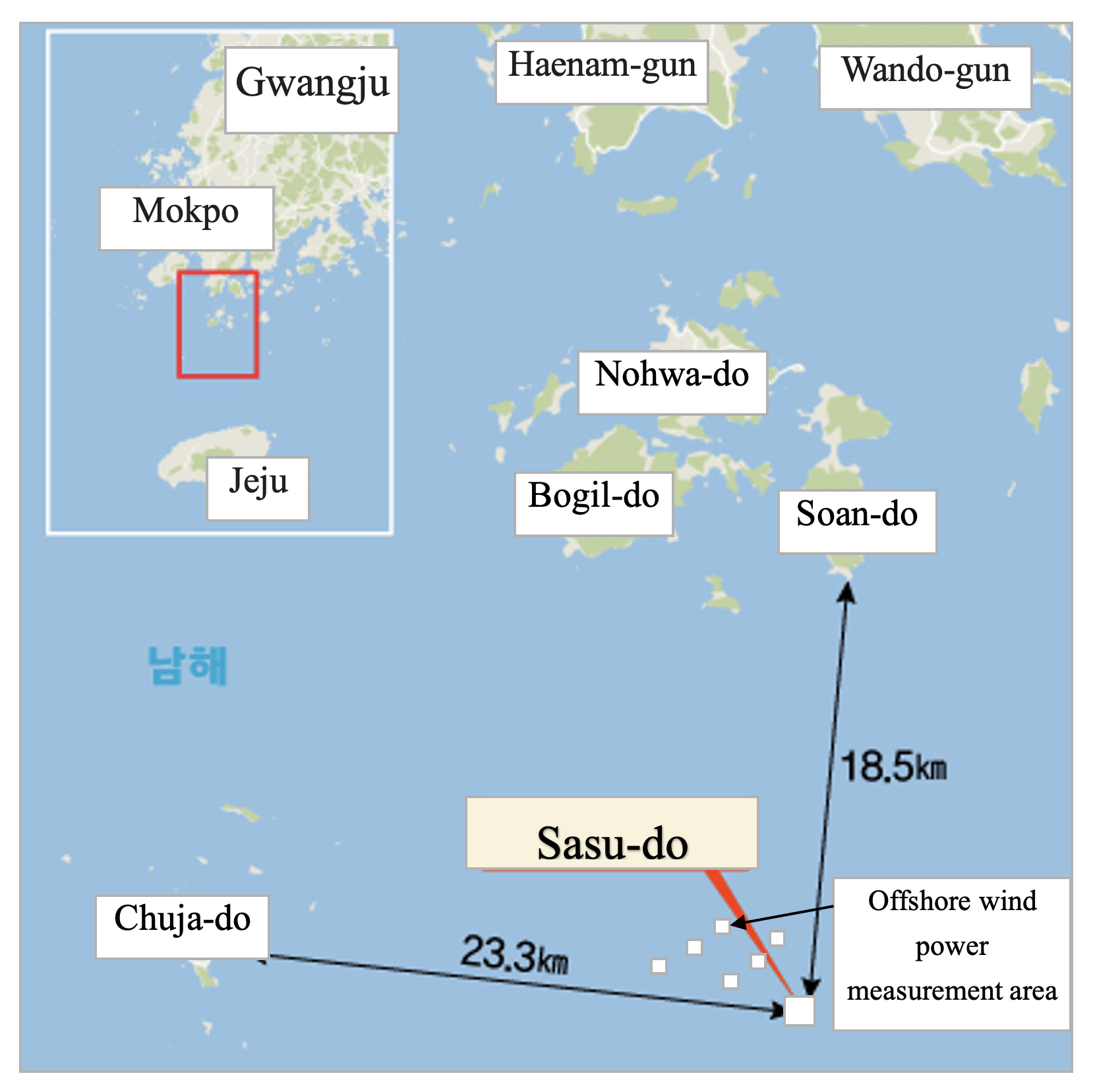
Maritime boundary disputes arise where the interests of nation-states or local governments intersect with the development of new marine industries. In Korea as well, conflicts over maritime boundary delimitation between local governments have been continuously raised; as of 2024, dozens of jurisdictional disputes have been filed or are still ongoing nationwide (Park & Park, 2025). At the same time, the emergence of large-scale marine industries—such as offshore wind power and submarine cable infrastructure—driven by climate-change mitigation has significantly altered both the nature and stakes of these disputes. Conflicts over offshore wind development between Tongyeong–Namhae (Gyeongnam Province) and the Gochang–Buan region (Jeonbuk Province), as well as jurisdictional clashes between Incheon’s Ongjin County and Taean County of Chungnam over marine aggregate extraction sites, are prominent examples. The Sasu-do waters, the focus of this study, lie between Wando County in Jeollanam-do and Jeju Special Self-Governing Province. Although it is a small island and its adjacent waters are limited in area, this region has long served as a key fishing ground for coastal small-scale fisheries. While previously considered a low-interest zone, the rapid rise of offshore wind development and other renewable-energy projects has significantly increased both its economic value and strategic importance. As a result, the legal dispute between Wando County and Jeju Province regarding jurisdiction over the Sasu-do maritime area has re-emerged with renewed intensity. In 2005, the Constitutional Court, in decision 2005Hun-Ra11, ruled that the island of Sasu-do itself belonged administratively to Jeju Province, based on cadastral records, forest ledgers, and land registers dating from around 1948. However, the Court expressly refrained from deciding the jurisdiction of the broader surrounding waters beyond a narrow 150-meter coastal strip (see Constitutional Court of Korea, Decision 2005Hun-Ra11, Oct. 27, 2005). This created a legal vacuum in which “the island belongs to Jeju, but the maritime boundaries remain undetermined,” an ambiguity now central to the current jurisdictional dispute linked to offshore wind development.
The aim of this study is to use the Sasu-do maritime dispute as a case to normatively analyze the structural characteristics of maritime boundary conflicts in Korea and, through comparative examination with international jurisprudence, propose rational criteria for maritime boundary delimitation. The research is guided by the following questions: the first, how do current laws and Constitutional Court precedents address the delimitation of waters surrounding small islands?, the second, how have the International Court of Justice (ICJ) and the International Tribunal for the Law of the Sea (ITLOS) delimited maritime boundaries in cases involving small islands or uninhabited islets?, the third, when these international standards are applied to the Sasu-do waters, which of the competing claims—Wando County or Jeju Province—possesses greater legal persuasiveness?
The scope of analysis includes: (1) Constitutional Court precedents, particularly the 2005Hun-Ra11 decision; (2) the facts and legal issues raised in the recent jurisdictional dispute concerning offshore wind development around Sasu-do; and (3) international case law (ICJ and ITLOS) on maritime delimitation and the effect of small islands. The methodology combines statutory interpretation, case analysis of Constitutional Court jurisdictional-dispute decisions, and comparative analysis of relevant international jurisprudence. Through this integrated approach, the study seeks to clarify the legal structure of the Sasu-do maritime dispute and identify pathways for improving Korea’s maritime boundary governance.
2. Overview of the Maritime Dispute and Structure of Key Issues
2.1. Geographical and Historical Characteristics of the Sasu-do Waters
Sasu-do is a small offshore island located between Soan-myeon of Wando County (Jeollanam-do) and Chuja-myeon of Jeju Province. Although limited in size, its surrounding waters have long served as important coastal fishing grounds. In recent years, expected demand for offshore wind and other renewable-energy projects has heightened intergovernmental tensions over the area. The maritime zone exhibits strong geographical and livelihood-based continuity with the Wando coastline, and local fishers’ daily practices, economic activities, and cultural perceptions demonstrate close ties to Wando. Meanwhile, although terrestrial administrative boundaries between local governments are clearly established, maritime boundaries frequently remain undefined, contributing to recurring conflicts such as those seen in this region.
2.2. The Hun-Ra11 Decision and Its Implications
In the 2005Hun-Ra11 decision, the Constitutional Court recognized the administrative affiliation of the island of Sasu-do with Jeju Province, relying on cadastral maps, forest ledgers, and registry records from around 1948[1]. The Court, however, explicitly limited its judgment to the “land portion” of the island and stated that the broader maritime area beyond approximately 150 meters from the shoreline remained outside the scope of review. Thus, although the decision clarified the jurisdiction over the island itself, it did notdetermine the jurisdiction over the surrounding maritime areas. It is therefore important to emphasize that the ruling did not confer comprehensive maritime jurisdiction around Sasu-do to Jeju Province.
2.3. Recent Jurisdictional Disputes Related to Offshore Wind Development
In 2023, Wando County granted permission for the use of public waters near Sasu-do for offshore wind power development. Jeju Province subsequently filed a constitutional jurisdictional dispute, claiming that the waters concerned fall under Jeju’s maritime jurisdiction and that Wando’s administrative action infringed Jeju’s authority. This case brought to the forefront the unresolved maritime jurisdictional vacuum left by the 2005Hun-Ra11 decision. The core issue is whether the administrative affiliation of Sasu-do with Jeju automatically implies that all surrounding waters belong to Jeju, or whether the island and its adjacent maritime space must be evaluated separately. Jeju Province argues its claim based on (1) maritime boundary markings in national base maps (e.g., 1973), (2) historical instances of administrative authority exercised in areas around Sasu-do, and (3) the purported intent of the 2005Hun-Ra11 decision. However, recent jurisprudence and administrative interpretations clarify that markings on national base maps do notautomatically possess legal binding force; only when long-term and consistent administrative practice is coupled with a legal conviction (opinio juris) may customary maritime boundaries be recognized. Wando County counters by asserting that (1) the 2005Hun-Ra11 ruling was limited solely to the island itself and did not determine jurisdiction over the surrounding waters; (2) national base maps have experienced changes, inconsistencies, and errors in maritime boundary depiction; and (3) the Sasu-do maritime area exhibits strong geographical and livelihood continuity with Wando, where fishing, licensing, and enforcement practices have been consistently carried out over an extended period. The fundamental dispute is therefore not about the existence of a map boundary, but whether actual administrative practice based on such maps has accumulated sufficiently to establish a customary maritime boundary.
3. Principles from International Jurisprudence on Maritime Boundary Delimitation
3.1. The Basic Framework of ICJ Jurisprudence
Modern international law on maritime boundary delimitation begins, above all, with the jurisprudence of the International Court of Justice (ICJ). Over several decades, the ICJ has played a central role in shaping the contemporary legal framework, progressively developing a methodology that harmonizes geometric equidistance with the overarching goal of equity[2]. This line of cases includes the landmark North Sea Continental Shelfjudgment (1969) and later decisions such as Qatar v. Bahrain (2001). In the North Sea Continental Shelf cases, the Court held that ‘the equidistance rule’ was not, at that time, a mandatory norm of customary international law. Rather, the objective of delimitation is to achieve “an equitable result.”[3] The Court clarified that equidistance is not an automatic rule but merely one technique, and that equitable principles play a significant role in maritime boundary delimitation (Tanaka, 2019).[4]Subsequent cases—including Qatar v. Bahrain (2001) and Cameroon v. Nigeria (2002)—refined the Court’s approach. The ICJ increasingly used equidistance as the starting point in practice, but affirmed that the final delimitation must still be evaluated against the standard of equity[5]. This jurisprudential trajectory culminated in the Maritime Delimitation in the Black Sea (Romania v. Ukraine, 2009), where the Court formally articulated the now well-established three-stage approach.[6] According to this three-stage approach: first, the Court constructs a ‘provisional equidistance line’. This requires identifying the relevant coasts of the parties, selecting appropriate ‘base points’, and drawing a line that connects points equidistant from both states. This provisional line is not the final boundary but serves as an objective geometric baseline. Second, the Court adjusts the provisional equidistance line in light of ‘relevant circumstances’. These include concavity or convexity of the coastline, the presence and location of small islands or rocks, the relative lengths of coastlines, and long-standing fishing or resource-extraction practices. Small islands and uninhabited islets are often given reduced effect, since applying full effect may push a state’s maritime jurisdiction disproportionately seaward or “cut off” the opposite state’s coastal projection[7]. Third, the Court conducts a ‘test of disproportionality’. This final review compares the ratio of relevant coastline lengths with the ratio of allocated maritime areas to ensure that the boundary line does not result in a “gross disproportionality.” This is not a mathematical requirement of strict proportionality; rather, it functions as a safeguard against distortions caused by specific geographic features[8].
These principles can be observed in the ICJ’s treatment of Serpents’ Island in the Black Sea case. Although Ukraine’s sovereignty over the island was recognized, the Court limited its effect in EEZ and continental shelf delimitation to essentially a 12-nautical-mile territorial sea, given its small size, limited population, and minimal economic or social function[9]. In Nicaragua v. Colombia (2012), the Court similarly distinguished between sovereignty over small islands—which it attributed to Colombia—and their limited effect on delimitation, allocating substantial maritime areas to Nicaragua in light of the geographical circumstances (Riesenberg, 2012)[10]. These cases collectively demonstrate that the ICJ may recognize sovereignty over an island while limiting its influence on maritime boundaries—separating titlefrom weight.
Thus, ICJ jurisprudence clearly establishes: the three-stage approach (provisional equidistance → adjustment for relevant circumstances → disproportionality test); the consistent trend of limiting the effect of small or uninhabited islands; and the prioritization of geographical continuity, coastal projection, and proportionality (Pranav & Laia, 2023)[11]. These principles have been widely adopted by other international tribunals, including ITLOS, and provide an essential analytical foundation for assessing maritime zones surrounding small islands such as Sasu-do.
3.2. Complementary Perspectives from ITLOS Jurisprudence
The International Tribunal for the Law of the Sea (ITLOS), established under Annex VI of the 1982 United Nations Convention on the Law of the Sea (UNCLOS), adjudicates disputes related to the law of the sea, including maritime boundary delimitation[12]. ITLOS generally follows the ICJ’s three-stage approach[13] but often incorporates a more explicit emphasis on patterns of actual maritime use and on environmental and resource-management considerations[14].
The Bangladesh/Myanmar (Bay of Bengal, 2012) case is illustrative (Alam, 2012)[15]. After identifying the relevant coasts and drawing a provisional equidistance line, the Tribunal examined whether the highly concave shape of the Bangladeshi coastline would produce a “cut-off effect,” effectively wedging Bangladesh into a severely restricted maritime space[16]. Concluding that retaining a strict equidistance line would be inequitable, the Tribunal adjusted the boundary to mitigate this structural disadvantage[17]. A second important precedent is the Ghana/Côte d’Ivoire (2017) case. Here, the Special Chamber examined not only geographic factors but also the long-term practice of petroleum exploration and development by the two states. The Chamber found that, prior to the dispute, the parties had effectively operated under a de facto equidistance-based boundary, and adopted a final adjusted equidistance line that maintained the stability of existing resource-management patterns[18]. These cases reveal several distinctive features of ITLOS jurisprudence: first, active modification of equidistancewhere structural disadvantages (such as coastal concavity) would otherwise produce inequitable outcomes. Scond, recognition of long-standing fisheries, resource extraction, and administrative practicesas relevant circumstances. Third, integration of UNCLOS principles on environmental protection and sustainable resource management, thereby framing maritime boundaries not merely as distributions of rights but also as allocations of responsibilities.
Applied to the Sasu-do dispute, these principles suggest that the Tribunal would examine; which local government has exercised sustained administrative authority (fishing regulation, licensing, enforcement); whether the area demonstrates geographical and functional continuity with Wando; and whether the small-island nature of Sasu-do warrants limiting its effect on the broader maritime area. Given these considerations, ITLOS jurisprudence supports treating the jurisdictional significance of Sasu-do separately from its sovereignty and assigning limited maritime effect to the island.
3.3. The Principle of Limited Effect of Small Islands and Its Application to Sasu-do
One of the clearest trends across both ICJ and ITLOS jurisprudence is the principle that small islands or uninhabited islets—particularly those lacking population or an independent socioeconomic base—should be given limited effectin maritime boundary delimitation[19]. This reflects the conceptual separation between the existence of an islandand the extent of its effecton delimitation.[20] In the Black Sea case, the ICJ recognized Ukraine’s title to Serpents’ Island but limited its maritime effect to a territorial sea, excluding it from influencing EEZ and continental shelf boundaries. Similarly, in Nicaragua v. Colombia, while the Court awarded sovereignty over numerous small Caribbean islands to Colombia[21], it allocated a substantial portion of the maritime area to Nicaragua based on coastal geography and proportionality, minimizing the influence of small insular features[22].
ITLOS has applied the same logic. In the Bangladesh/Myanmarcase, the Tribunal adjusted the provisional equidistance line to prevent Bangladesh from being structurally disadvantaged by the concavity of its coast. In Ghana/Côte d’Ivoire[23], the Tribunal analyzed long-standing petroleum development patterns and avoided giving disproportionate effect to small islands or underwater features[24]. Applied to Sasu-do, several points emerge: first, Sasu-do is a small island without a resident population or independent socioeconomic functions. In this respect, it resembles Serpents’ Island and other uninhabited islets whose maritime effect has been limited in ICJ and ITLOS cases. Georaphical continuity strongly favors Wando. The contested waters lie closer to the Wando coast, and the area has long served as a primary fishing ground for Wando’s fishers. Administrative practice historically centers on Wando. Public-water permits, fisheries oversight, and enforcement activities have often been exercised by Wando County[25], whereas Jeju’s administrative activities have largely concerned the island itself and its immediate coastal belt (with more active involvement only after 2015)[26]. Second, the Constitutional Court’s 2005Hun-Ra11 decision in 2005 determined only the administrative affiliation of the island of Sasu-do itself, without reaching any explicit conclusion regarding the jurisdiction over the surrounding maritime areas as a whole[27].In other words, the Constitutional Court institutionally separated the question of the island’s affiliation from that of the surrounding waters, a structure that parallels the approach taken in ICJ and ITLOS jurisprudence, which distinguishes between the sovereignty of an island and its effect on maritime delimitation. Therefore, the mere fact that “Sasu-do belongs to Jeju Province” does not automatically lead to the conclusion that “the broad maritime areas around Sasu-do must also fall under Jeju’s jurisdiction.” Rather, when viewed in light of trends in both international law and domestic precedent, it is more logically consistent to recognize the island’s affiliation with Jeju while delimiting the surrounding maritime jurisdiction on the basis of independent criteria. Third, from the perspective of proportionality and equity, assigning most of the disputed maritime area to Jeju solely on the basis of Sasu-do would likely create a serious imbalance between the ratio of coastline lengths and the ratio of maritime areas allocated.Considering the length of the Wando–Jeonnam coastline, the associated population and economic scale, and the extremely small and uninhabited nature of Sasu-do, the result could be evaluated as “gross disproportionality” under the ICJ’s proportionality test. This implies that limiting the effect of a small island in maritime boundary delimitation—and prioritizing geographical continuity, livelihood patterns, and economic linkages with the Wando coast—is consistent with international jurisprudence. Taken together, a reasonable interpretation of jurisdiction over the Sasu-do maritime area can be summarized as follows. First, for Sasu-do itself and a narrow belt of adjacent waters (e.g., a territorial-sea-scale zone such as 12 nautical miles or smaller), Jeju’s jurisdiction should be recognized in accordance with the 2005Hun-Ra11 decision. Second, for the broader disputed maritime area located at some distance from the island, the provisional equidistance line between Wando and Jeju should serve as a baseline, but should be adjusted in favor of Wando by considering relevant circumstances such as Sasu-do’s small and uninhabited character, the geographical continuity with the Wando coast, and the long-standing fishing practices of Wando fishers. Third, in core areas where offshore wind development overlaps with traditional fisheries, it is necessary to adopt a joint-management and benefit-sharing model involving both local governments and relevant stakeholders—consistent with ITLOS jurisprudence—in order to mitigate substantive conflicts independently of the jurisdictional dispute itself.
4. Domestic Legal Framework and Constitutional Court Decisions on Maritime Boundary Conflicts in Korea
4.1. Structure and Limitations of the Legal Framework Governing Maritime Boundaries
The current Local Autonomy Actstipulates that the names and jurisdictions of local governments shall “remain as previously designated,” while their alteration, abolition, establishment, or consolidation must be determined by statute (Local Autonomy Act, art. 5). This provision declares that the jurisdictional boundaries of local governments are, in principle, determined by law, but it focuses primarily on land boundaries and does not provide explicit criteria for maritime boundaries, including those involving public waters[28]. Meanwhile, the Act on Management and Reclamation of Public Waters aims to conserve and manage public waters and regulate the ownership and use of reclaimed land, and it contains provisions determining whether reclaimed areas belong to the state or local governments[29]. However, this statute primarily governs the ownership and management of reclaimed land afterreclamation has occurred, rather than providing advance criteria for delimiting jurisdiction over existing public waters (Cho, 2016)[30].
Since the 2010s, amendments to the Local Autonomy Act have partially institutionalized issues related to public-water boundaries and the jurisdiction over reclaimed land. Under the revised framework, authority over determining the jurisdiction of reclaimed land is vested in the Supreme Court, while the authority to set boundaries of public waters is divided between the Minister of the Interior and Safety and the Constitutional Court through jurisdictional dispute procedures (Cho, 2016). Nevertheless, despite these institutional changes, concrete and generalizable criteria for allocating existing maritime areas (public waters) among local governments remain insufficient. As a result, when maritime boundary disputes arise, the Minister of the Interior and Safety’s boundary decisions, the Supreme Court’s rulings, and the Constitutional Court’s jurisdictional-dispute judgments generally address the issues on a case-by-case and ex post factobasis[31]. In summary, while Korean law contains relatively detailed provisions regarding the jurisdiction and ownership of reclaimed land, criteria governing the boundaries of existingpublic waters remain abstract. This legal gap functions as a structural cause of recurring maritime boundary conflicts among local governments.
4.2. Constitutional Court Jurisprudence on Jurisdictional Disputes Concerning Public Waters and Maritime Boundaries
This section examines two significant jurisdictional-dispute decisions involving local governments and maritime boundaries: the Gyeongsangnam-do v. Jeollanam-docase (2015Hun-Ra7) and the Namhae-gun v. Tongyeong-sicase (2022Hun-Ra1). The two decisions stand in contrast: the former recognized an unwritten customary maritime boundary based on long-standing administrative practice, whereas the latter found no such customary boundary and independently delimited a maritime boundary based on equity.
The 2015Hun-Ra7dispute—widely known as the contest over the “golden anchovy fishing grounds” off Namhae (Gyeongnam) and Yeosu (Jeonnam)—involved conflicting jurisdictional claims between Gyeongsangnam-do and Namhae-gun on one side, and Jeollanam-do and Yeosu-si on the other[32]. The claimants argued that the maritime boundary depicted in the 1973 national base map could not serve as a legal criterion for determining the jurisdiction between local governments, and that the disputed waters historically fell under their authority. Jeollanam-do and Yeosu-si, by contrast, asserted jurisdiction based on the national base map and the long-standing administrative, fisheries, and enforcement practices associated with it[33]. On February 25, 2021, the Constitutional Court unanimously dismissed the claims and upheld the existing maritime boundary[34]. The Court articulated the following three-step legal framework for determining jurisdiction over public waters: (1)If an express statutory provision defines the jurisdictional boundary between local governments in public waters, that provision controls. (2)If no such statute exists, an unwritten customary maritime boundary may be recognized if there is long-standing and consistent administrative practice combined with opinio juris (a legal conviction that such practice constitutes law). (3)If neither an express statutory boundary nor a customary boundary exists, the Constitutional Court must itself delimit the maritime boundary based on principles of equity, because a jurisdictional “vacuum” between local governments cannot be permitted[35].
In this case, the Court held that although the national base map alone does not automatically create a boundary, the decades-long reliance by central and local authorities, fisheries agencies, and maritime police on the 1973 boundary line—combined with widespread recognition of that line as the operative jurisdictional boundary—gave rise to an unwritten customary maritime boundary. Thus, it was not the map itself that created the boundary; rather, the long-standing administrative practices based on the map, coupled with legal conviction, collectively formed a customary maritime boundary[36]. This decision is significant because it confirms that (1) public waters fall within the scope of local autonomous authority, (2) maritime boundaries on national base maps may gain legal effect under certain conditions through customary practice, and (3) the Constitutional Court is reluctant to alter boundaries that have been relied upon for decades (reflecting legal stability and protection of legitimate expectations).
By contrast, the 2022Hun-Ra1dispute between Namhae-gun and Tongyeong-si concerned a maritime boundary between basic-level municipalities within Gyeongsangnam-do. The conflict arose in the public waters east of Yokjido Island (around Gudolseo), involving fisheries operations and offshore wind development[37]. Tongyeong-si granted shrimp-trawl fishing permits and public-water use authorizations in the disputed area based on its assumption of jurisdiction, prompting Namhae-gun to challenge these actions before the Constitutional Court. On August 29, 2024, in a 5–4 decision, the Court upheld Namhae-gun’s claim[38]. The majority held: First, the national base map does not have automatic legal effect; maritime lines drawn for cartographic convenience do not, by themselves, create jurisdictional boundaries between local governments[39]. Second, no unwritten customary maritime boundary existed. The Court found insufficient evidence of long-standing, exclusive administrative practice—such as fisheries licensing, public-water permits, or enforcement—combined with reciprocal acceptance (opinio juris) that would indicate recognition of a customary boundary between Namhae and Tongyeong (Seung, 2025)[40]. Third, the Court directly delimited the maritime boundary based on equity. In the absence of statutory or customary boundaries, the Court determined that it must delineate the boundary itself. It adopted an equidistance/midline approach, using the uninhabited islet Gudolseo (part of Namhae-gun) as an “important uninhabited island,” along with Tongyeong’s inhabited islands (Dumido, Yokjido), as base points[41]. The Court then drew an equidistant line and adopted it as the final boundary. The Court emphasized that uninhabited islands that are geographically and functionally significant in a disputed maritime area may also be considered in equitable delimitation. Four justices dissented, arguing that granting an uninhabited islet such as Gudolseo the same weight as inhabited islands violated equity. They proposed a weighted equidistance line, applying a 1:3 ratio between inhabited and uninhabited islands to limit the influence of the latter. The dissenters contended that this approach better reflected “specific equity.”
This decision is important because it (1) expressly denies any automatic legal effect to national base-map maritime lines, (2) sets a high threshold for recognizing unwritten customary maritime boundaries (requiring long-term practice plus opinio juris) (Seung, 2025), and (3) demonstrates that, where these conditions are not met, the Constitutional Court may effectively act as a domestic maritime-boundary tribunal, directly delimiting boundaries based on equity.
4.3. Comparison of the Two Cases and Their Implications
A comparison between the Gyeongnam–Jeonnam case (2015Hun-Ra7) and the Namhae–Tongyeong case (2022Hun-Ra1) shows that the Constitutional Court’s jurisprudence on maritime boundaries has evolved from an approach emphasizing “stability based on the national base map and administrative practice” to one that places greater emphasis on “strict requirements for practice and opinio jurisand direct delimitation based on equity.” In the 2015Hun-Ra7 case, decades of accumulated administrative and judicial practice by central and local governments, as well as fisheries and maritime police authorities, had relied on the maritime boundary depicted in the national base map. Based on this long-standing practice, the Court recognized the existence of an unwritten customary maritime boundary and upheld the existing boundary. In the 2022Hun-Ra1 case, however, the Court found that no such long-term and consistent practice existed. Rejecting reliance on the national base map and fragmentary administrative practices, the Court directly delimited the maritime boundary by itself, drawing an equidistance/midline line and taking into account the effect of an “important uninhabited island.” This jurisprudential trend suggests that in future disputes involving jurisdiction over the waters surrounding small islands or uninhabited islets—such as the Sasu-do maritime area—boundaries cannot be justified solely by reference to the national base map or isolated administrative practices. In the absence of long-standing and consistent practice supported by opinio juris, the Constitutional Court is likely to delimit maritime boundaries directly according to the principle of equity. In doing so, it may actively draw upon international jurisprudence (ICJ and ITLOS), including the equidistance/relevant circumstances/disproportionality methodology and the doctrine of limiting the effect of small islands.
5. Conclusion
This study examined the Sasu-do maritime dispute by synthesizing relevant international jurisprudence (ICJ and ITLOS) and domestic Constitutional Court decisions concerning competence disputes over maritime boundaries. The implications of these legal frameworks were then applied to the question of jurisdiction over the Sasu-do waters. The main conclusions and policy and academic implications are as follows.
First, from an international-law perspective, the ICJ and ITLOS consistently employ a shared three-stage methodology—provisional equidistance, adjustment for relevant circumstances, and a disproportionality test—while limiting the effect of small islands and uninhabited islets. As demonstrated in cases involving Serpents’ Island and small Caribbean islands, the courts often grant only a territorial-sea–level effect to islands lacking population or independent socioeconomic functions, or exclude them from influencing EEZ and continental shelf boundaries altogether. In this view, the decisive elements in maritime delimitation are not the mere presence of an island as a “point,” but the overall configuration of the coastline, relative population and economic scale of the hinterland, long-term usage and administrative practice, and the rationality of outcomes confirmed through proportionality review.
Second, the evolution of domestic law and Constitutional Court jurisprudence shows substantial convergence with international case law rather than divergence. Although the Local Autonomy Actand the Act on the Management and Reclamation of Public Watersdo not provide sufficiently explicit standards for maritime boundaries, the Constitutional Court—through cases such as the Cheonsu Bay dispute, the Gyeongnam–Jeonnam case, and the Namhae–Tongyeong case—has recognized the autonomous authority of local governments over public waters and articulated a three-step review framework: statutory provisions, unwritten customary maritime boundaries (long-term practice + opinio juris), and, in the absence of both, direct equitable delimitation by the Court. In particular, in the recent Namhae–Tongyeong case, the Court rejected the automatic legal effect of the national base map and, finding no long-standing practice or opinio juris, directly delimited the maritime boundary based on equidistance and geographical and functional considerations, effectively acting as a “domestic maritime boundary tribunal.”
Third, applying these international and domestic jurisprudential trends to the Sasu-do dispute makes it clear that the affiliation of the island and the jurisdiction over the surrounding waters must be evaluated separately. The 2005Hun-Ra11 decision recognized Jeju’s administrative jurisdiction over Sasu-do itself but expressly refrained from deciding the jurisdiction over the broader disputed waters. Since international case law permits separating island sovereignty from maritime boundary effects, and domestic jurisprudence also treats islands and public waters independently, the fact that “Sasu-do = Jeju” does not logically lead to “the surrounding waters = Jeju.” Rather, considering Sasu-do’s uninhabited and economically limited character, its geographical proximity and functional continuity with the Wando coast, the long-standing fishing patterns of Wando fishers, and Wando County’s administrative practices, it is more consistent with both international and domestic jurisprudence to regard much of the disputed area as falling under Wando’s jurisdiction.
Fourth, from a policy perspective, the Sasu-do dispute signals that maritime boundary conflicts will likely increase as competition over ocean space intensifies—particularly due to offshore wind development, marine tourism, and marine protected area designations. Because the current legal framework does not provide sufficiently general or systematic criteria for maritime boundary-setting, it is necessary to institutionalize such standards through amendments to the Local Autonomy Actor through a dedicated “Special Act on Maritime Boundaries and Marine Spatial Governance.” Such a law should establish clear criteria for delimitation among local governments (equidistance, relevant circumstances, proportionality), principles for limiting the effect of small islands, procedures for mediation and arbitration, and frameworks for joint management and benefit sharing. In areas like Sasu-do—where traditional fisheries overlap with offshore wind development—mechanisms for joint management and profit-sharing should be implemented alongside jurisdictional determinations to mitigate conflict and promote the sustainable use of marine space.
Fifth, academically, the Sasu-do dispute provides a valuable interdisciplinary research arena that spans international maritime law, domestic autonomy law, marine spatial planning, and regional policy studies. While this article has focused primarily on normative legal analysis, future research should incorporate GIS-based geomorphological analysis, economic assessments using fisheries, tourism, and energy data, and qualitative and quantitative field studies involving residents, fishers, and local governments. Furthermore, once the Constitutional Court issues its final ruling on the Sasu-do case, follow-up research should evaluate its implications for Korea’s maritime-boundary regime and for future offshore wind development policies. Ultimately, the Sasu-do maritime dispute serves as an important test case for determining how the relationship between small islands and surrounding waters should be regulated; how marine-space development can be harmonized with traditional fisheries and environmental protection; and how authority should be allocated between central and local governments and among local governments themselves. It is hoped that the international and domestic jurisprudential analysis and legal assessment presented in this study will serve as a foundation for establishing more rational and equitable maritime-boundary standards and marine spatial-governance models in the future.
Acknowledgments
This research was supported by Glocal University Project of Mokpo National University, 2025.
Endnotes
[1] The Constitutional Court, in the 2005Heon-Ra11 case, recognized only the administrative affiliation of the island of Sasu-do itself with Jeju Province, while expressly reserving judgment on the jurisdiction over the broader surrounding waters beyond a narrow coastal belt of approximately 150 meters from the shoreline.
[2] International Court of Justice, North Sea Continental Shelf (Federal Republic of Germany/Denmark; Federal Republic of Germany/Netherlands), Judgment of 20 February 1969, I.C.J. Reports 1969, p.3.; International Court of Justice, Maritime Delimitation and Territorial Questions between Qatar and Bahrain (Qatar v. Bahrain), Merits, Judgment of 16 March 2001, I.C.J. Reports 2001, p.40.
[3] International Court of Justice, 1969, op.cit, p.3..
[4] Yoshifumi Tanaka, The International Law of the Sea, 3rd ed., Cambridge University Press, 2019, pp.232~241.
[5] International Court of Justice, 2001, op.cit., p.40.; International Court of Justice, 2002, op.cit.; Yoshifumi Tanaka, op.cit.
[6] International Court of Justice, Maritime Delimitation in the Black Sea (Romania v. Ukraine), Judgment of 3 February 2009, I.C.J. Reports 2009, p.61.; Yoshifumi Tanaka, op.cit.
[7] ibid.
[8] ibid.
[9] International Court of Justice, Territorial and Maritime Dispute (Nicaragua v. Colombia), Judgment of 19 November 2012, I.C.J. Reports 2012, p.624.
[10] Riesenberg, D.P., 2012. Territorial and Maritime Dispute (Nicaragua v. Colombia), ICJ Introductory Note, International Legal Materials 52(1), pp.1~71
[11] Pranav, G. , Laia R. G, 2023, The ICJ judgment on Nicaragua v Colombia (2022): applying an established jurisdictional test or a problematic invention?, Journal of International Dispute Settlement, Vol.14(3), pp.1~16.
[12] United Nations, United Nations Convention on the Law of the Sea, 1982, Annex VI (Statute of the International Tribunal for the Law of the Sea).
[13] International Tribunal for the Law of the Sea (ITLOS), Delimitation of the Maritime Boundary in the Bay of Bengal (Bangladesh/Myanmar), Judgment, 14 March 2012, ITLOS Reports 2012, p.4.
[14] Yoshifumi Tanaka, op.cit.
[15] M. Khurshid Alam, “Delimitation of Maritime Boundary between Bangladesh and Myanmar in the Bay of Bengal,” Northern University Journal of Law, 2012.
[16] ibid.
[17] ITLOS, Dispute concerning Delimitation of the Maritime Boundary between Ghana and Côte d’Ivoire in the Atlantic Ocean (Ghana/Côte d’Ivoire), Judgment, 23 September 2017, ITLOS Case No. 23.
[18] International Court of Justice, 2009, op.cit., p.61.
[19] International Court of Justice, 2009, op.cit., p.61.
[20] International Tribunal for the Law of the Sea (ITLOS), op.cit., p.4.
[21] International Court of Justice, Territorial and Maritime Dispute (Nicaragua v. Colombia), Judgment of 19 November 2012, I.C.J. Reports 2012, p. 624.
[22] International Tribunal for the Law of the Sea (ITLOS), Dispute concerning Delimitation of the Maritime Boundary between Ghana and Côte d’Ivoire in the Atlantic Ocean (Ghana/Côte d’Ivoire), Judgment, 23 September 2017, ITLOS Case No. 23.
[23] International Tribunal for the Law of the Sea (ITLOS), 2012, op.cit.
[24] International Tribunal for the Law of the Sea (ITLOS. 2017, op.cit.
[25] “Jeju Province also appears to have exercised certain oversight and enforcement in the area, and has done so more actively since 2015 following the Constitutional Court’s ruling.” (personal communication)
[26] Yoshifumi Tanaka, op.cit.
[27] Constitutional Court of Korea, Decision 2005Hun-Ra11, Oct. 27, 2005, Sasu-do Jurisdictional Dispute
[28] Ministry of Government Legislation, “Types and Jurisdictions of Local Governments,” 2020. (Korean)
[29] “The Act on the Management and Reclamation of Public Waters and its Enforcement Decree and Administrative Regulations (particularly the provisions on the ownership and management of reclaimed land).”
[30] Cho, Jae-Hyun, 「A study on the binding effect of the decision on competence dispute by the Constitutional Court in amendment of the Local Government Act - focus on the decision of the Constitutional Court over the jurisdiction on the boundary of public waters -」, 『Journal of Constitutional Justice』, 2016., pp.27~55.
[31] “See news reports on the Pyeongtaek–Dangjin Port reclamation dispute (e.g., The Hankyoreh; Pyeongtaek Citizen Newspaper) and summaries of the Supreme Court decision and amendments to the Local Autonomy Act.” (Korean)
[32] Constitutional Court of Korea, Press Release, “2015Hun-Ra7: Competence Dispute between Gyeongsangnam-do et al. and Jeollanam-do et al.,” February 25, 2021. (Korean)
[33] The Law Times, “Jeonnam Prevails in the ‘Gyeongnam Namhae–Jeonnam Yeosu Anchovy Fishery Dispute,’” February 25, 2021.(Korean)
[34] Constitutional Court of Korea, Decision 2022Hun-Ra1, “Competence Dispute between Namhae-gun and Tongyeong-si of Gyeongsangnam-do,” delivered on August 29, 2024 (decision text and press release).
[35] Constitutional Court of Korea, Decision 2015Hun-Ra7, “Competence Dispute between Gyeongsangnam-do et al. and Jeollanam-do et al.,” Summary of Decision and Holdings, February 25, 2021.
[36] Kim & Chang Law Firm, “The First Case Recognizing an Unwritten Maritime Boundary—Rather Than the Equidistance/Midline or Equity Principle—in a Competence Dispute between Local Governments,” Newsletter, March 4, 2021.
[37] Constitutional Court of Korea, Decision 2022Hun-Ra1, “Competence Dispute between Namhae-gun and Tongyeong-si of Gyeongsangnam-do,” delivered on August 29, 2024 (decision text and press release).
[38] The Korea Economic Daily, “Namhae-gun Effectively Wins Maritime Boundary Lawsuit against Tongyeong-si… Secures Its Golden Fishing Grounds,” September 2, 2024.
[39] Constitutional Court of Korea, Decision 2022Hun-Ra1 (August 29, 2024)
[40] Seung, Lee-Do, The Dispute over Maritime Delimitation and the Adjustment of island influence- focusing of Constitutional Court Decision 2022Hun-Ra1 (August 29, 2024), Public Land Law Review, 2025. pp.79~112..
[41] The Korea Economic Daily, “Namhae-gun Effectively Wins Maritime Boundary Lawsuit against Tongyeong-si… Secures Its Golden Fishing Grounds,” September 2, 2024.
References
- Alam, M. K., 2012. Delimitation of Maritime Boundary between Bangladesh and Myanmar in the Bay of Bengal, Northern University Journal of Law.
- Cho, J.-H., 2016. A study on the binding effect of the decision on competence dispute by the Constitutional Court in amendment of the Local Government Act - focus on the decision of the Constitutional Court over the jurisdiction on the boundary of public waters -, Journal of Constitutional Justice, 3(1): 27-55.
- Constitutional Court of Korea. 2025. Decision 2005Hun-Ra11 (Sasu-do Competence Dispute). Delivered October 27, 2005.
- Constitutional Court of Korea. 2024. Decision 2022Hun-Ra1, “Competence Dispute between Namhae-gun and Tongyeong-si of Gyeongsangnam-do.”Delivered August 29, 2024 (decision text and press release).
- Constitutional Court of Korea. 2021. Press Release, 2021. “2015Hun-Ra7: Competence Dispute between Gyeongsangnam-do et al. and Jeollanam-do et al.”February 25, 2021.
- Constitutional Court of Korea. 2021. Decision 2015Hun-Ra7, “Competence Dispute between Gyeongsangnam-do et al. and Jeollanam-do et al.”Summary of Decision and Holdings, February 25, 2021.
- International Court of Justice, 1969. North Sea Continental Shelf (Federal Republic of Germany/Denmark; Federal Republic of Germany/Netherlands), Judgment of 20 February 1969, I.C.J. Reports 1969, p.3
- International Court of Justice, 2001. Maritime Delimitation and Territorial Questions between Qatar and Bahrain (Qatar v. Bahrain), Merits, Judgment of 16 March 2001, I.C.J. Reports, p. 40.
- International Court of Justice, 2009. Maritime Delimitation in the Black Sea (Romania v. Ukraine), Judgment of 3 February 2009, I.C.J. Reports 2009, p.61.
- International Court of Justice, 2012. Territorial and Maritime Dispute (Nicaragua v. Colombia), Judgment of 19 November 2012, I.C.J. Reports, p.62.
- International Tribunal for the Law of the Sea (ITLOS), 2017. Dispute concerning Delimitation of the Maritime Boundary between Ghana and Côte d’Ivoire in the Atlantic Ocean (Ghana/Côte d’Ivoire), Judgment, 23 September 2017, ITLOS Case No.23.
- International Tribunal for the Law of the Sea (ITLOS), 2012. Delimitation of the Maritime Boundary in the Bay of Bengal (Bangladesh/Myanmar), Judgment, 14 March 2012, ITLOS Reports 2012, p.4.
- ITLOS, 2017. Dispute concerning Delimitation of the Maritime Boundary between Ghana and Côte d’Ivoire in the Atlantic Ocean (Ghana/Côte d’Ivoire), Judgment, 23 September 2017, ITLOS Case No. 23.
- Local Autonomy Act, Article 5 (“Names and Jurisdictions of Local Governments”)
- Ministry of Government Legislation. 2020. Types and Jurisdictions of Local Governments. MOLEG Knowledge Archive.
- Park, S.-H., Park, J.-I., 2025. From Uncertainty to Conflict: A Transaction Cost Perspective on Maritime Boundary Disputes Among Local Govern, Journal of The Korean Cadastre Information Association, 27(2): 126-141.
- Pranav, G. , Laia R. G, 2023, The ICJ judgment on Nicaragua v Colombia (2022): applying an established jurisdictional test or a problematic invention?, Journal of International Dispute Settlement, 14(3): 1-16.
- Riesenberg, D.P., 2012. Territorial and Maritime Dispute (Nicaragua v. Colombia), ICJ Introductory Note, International Legal Materials, 52(1): 1-71.
- Seung, L.-D., 2025. The Dispute over Maritime Delimitation and the Adjustment of island influence- focusing of Constitutional Court Decision 2022hun-ra1 (August 29, 2024). Public Land Law Review, pp.79-112.
- Tanaka, Y., 2019. The International Law of the Sea (3rd ed.), Cambridge University Press, pp.232-241.
- United Nations, 1982. United Nations Convention on the Law of the Sea, Annex VI (Statute of the International Tribunal for the Law of the Sea).
- Youn, Y.-M., 2018. An Analysis of ITLOS Judgment on the Dispute Concerning Delimitation of the Maritime Boundary between Ghana and Côte D'ivoire in the Atlantic Ocean and It's Implications. Maritime Law Review, 30(3):1-24.
Newspaper and other communications
- Act on the Management and Reclamation of Public Waters, its Enforcement Decree, and related Administrative Regulations (particularly provisions on the ownership and management of reclaimed land).
- Kim & Chang Law Firm. 2021. The First Case Recognizing an Unwritten Maritime Boundary—Rather Than the Equidistance/Midline or Equity Principle—in a Competence Dispute between Local Governments. Newsletter, March 4, 2021.
- News reports on the jurisdictional dispute over the reclaimed land at Pyeongtaek–Dangjin Port (e.g., The Hankyoreh; Pyeongtaek Citizen Newspaper), and articles summarizing the Supreme Court ruling and legislative developments concerning amendments to the Local Autonomy Act.
- The Korea Economic Daily. 2024. Namhae-gun Effectively Wins Maritime Boundary Lawsuit against Tongyeong-si… Secures Its Golden Fishing Grounds. September 2, 2024.
- The Law Times. 2021. Jeonnam Prevails in the ‘Gyeongnam Namhae–Jeonnam Yeosu Anchovy Fishery Dispute.’ February 25, 2021.